Browse Listings
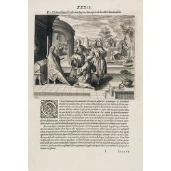
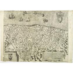
Funeral in China.
A scene of a funeral in China from Linschoten's famous voyages to the East of 1583-92 here published by De Bry the year after they first appeared as a separate book. From...
Place & Date: Frankfurt, 1599

XV. Ratio Homines Ex Uno Loco In alium gestandi.
Scene in the kingdom of Pegu, now Myanmar, showing elephant, ships and locals.Theodore de Bry, a German engraver and book dealer, began a compilation of early voyages in ...
Place & Date: Frankfurt, 1599

Geometria, from The Seven Liberal Arts.
A female figure with a castle on her head measures a globe with a compass; representing geometry. Engraving by Johann Sadeler I after M. de Vos.
Place & Date: Antwerp, 1570 - 1600
![Le Roy de Navarra venant à Paris recheut le coup de cousteau au visaige par ung Pierre Chastel, lequel par quatre chevaulx fut tiré en pièces, faict le 27 de Decemb[re] l'an 1594.](/uploads/cache/38548-250x250.jpg)
Le Roy de Navarra venant à Paris recheut le coup de cousteau au visaige par ung Pierre Chastel, lequel par quatre chevaulx fut tiré en pièces, faict le 27 de Decemb[re] l'an 1594.
Engraved news-sheet with text in German and French. Pictorial reportage on the failed assassination attempt on King Henri IV of France by Jean Châtel (here identified as...
Place & Date: Cologne, ca. 1600
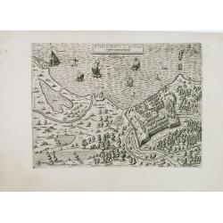
Il vero ritratto di Nettvno al presente oaupato da gl'imperiali.
Rare and early town-plan of Nettuno, in the province of Rome, which is nowadays a touristic harbor.Issued by Joannes Orlandi who acquired many Lafreri plates, which he re...
Place & Date: Rome, 1557 / 1602
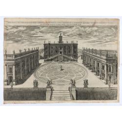
Capitolii sciographia ex ipso exemplari Michaelis Angeli Bonaroti a Stephano Duperac Parisiensi accurate delineata…
View of the Roman Capitol as re-designed by Michelangelo, from "Speculum Romanae Magnificentiae", first published in 1569, this example edited by Giovanni Orlan...
Place & Date: Rome, Orlandi, 1602
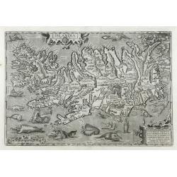
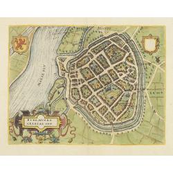
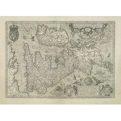
Islandia.
Perhaps the most famous map of Iceland. On the south side of the island a collection of all possible sea monsters is depicted. Polar bears on ice flows and volcanoes in t...
Place & Date: Antwerp, 1603
![[Title page] Perspective die hooch-gheroemde conste..](/uploads/cache/25554-250x250.jpg)
[Title page] Perspective die hooch-gheroemde conste..
Title page from Perspective, Dat is, de hooch-gheroemde conste eens schijnende in oft door-siende ooghen-ghesichtespunt ... (&c.) by Hans, or Johannes Vredeman de Vri...
Place & Date: Leiden, 1604
La marca d'Ancona. Marchia Anconitana Picaenum olim dicta. . . Romae apud Joannem Orlandini formis Rome 1604.
A re-issue of the plate by Vicentium Luchinù of 1564 now with the address of Orlandini and the dates 1602 / 1604.Collector's item. A unique opportunity to acquire a fine...
Place & Date: Rome, 1604
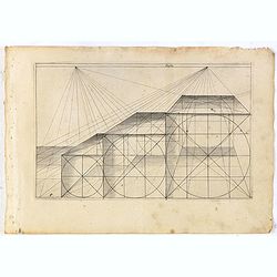
Perspective print by Vredeman de Vries. 5
Engraving from Perspective, c'est a dire, le tresrenomme art du poinct oculaire d'une veue dedans ou travers regardante, estant sur une muraille unie, sur un tableau, ou ...
Place & Date: The Hague, 1604 - 1605
![[Title page] Geographiae libri octo Graeco-Latini . . .](/uploads/cache/47936-250x250.jpg)
[Title page] Geographiae libri octo Graeco-Latini . . .
Fine decorative titlepage from the 1605 edition of Ptolemy. The plate is adorned with allegorical figures, fruits and architectural motifs. This 1605 edition was based on...
Place & Date: Amsterdam, 1605
Perspective print by Vredeman de Vries.
Engraving from Les cinq rangs de l'architecture, a savoir, Tuscane, dorique, ionique, corinthiaque et composée avec l'instruction fondamentale. by Paul Vredeman de Vries...
Place & Date: The Hague, 1606
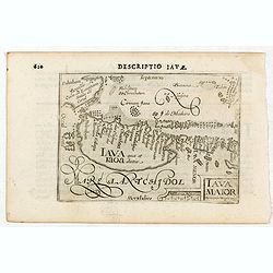
Iava Maior.
Very fine miniature map of Java, engraved by Benjamin Wright (1575-1613). This early map contains detailed geography and nomenclature around the northern coastline of the...
Place & Date: Amsterdam, Cornelis Claes, 1606
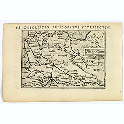
Ultrajectum.
An original early 17th century copper engraved miniature antique map of the Dutch province of Utrecht by Petrus Bertius, that was published in Amsterdam at the beginning ...
Place & Date: Amsterdam, 1606
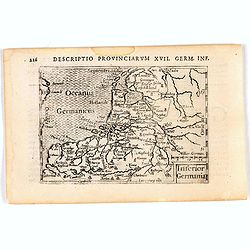
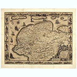
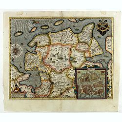
Inferior Germania.
A rare miniature map of present-day The Netherlands and Belgium. Strap-work title cartouche in the lower right corner with scale. Expertly engraved by Petrus Kaerius, the...
Place & Date: Amsterdam, 1606
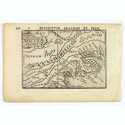
Aracam.
A rare miniature map of Thailand and Burma. Title cartouche on the upper left corner. First published in 1598 in his 'Caert-Thresoor', the plates were executed by the mos...
Place & Date: Amsterdam, 1606
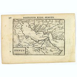
Ormus
A lovely map of miniature map the Kingdom of Ormus, published by Petrus Bertius, and published in Amsterdam at the beginning of the seventeenth century. With an attractiv...
Place & Date: Amsterdam, 1606
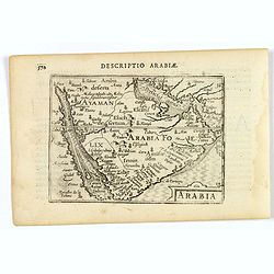
Arabia
A lovely miniature map the Arabian Peninsular, published by Petrus Bertius, and published in Amsterdam at the beginning of the seventeenth century. With an attractive s...
Place & Date: Amsterdam, 1606

Perspective print by Vredeman de Vries.
Engraving from Les cinq rangs de l'architecture, a savoir, Tuscane, dorique, ionique, corinthiaque et composée avec l'instruction fondamentale. by Paul Vredeman de Vries...
Place & Date: The Hague, 1606
![[Perspective print after J. Vredeman de Vries. ]](/uploads/cache/26445-250x250.jpg)
[Perspective print after J. Vredeman de Vries. ]
Engraving depicting the use of the vanishing point. From Les cinq rangs de l'architecture, a savoir, Tuscane, dorique, ionique, corinthiaque et composée avec l'instructi...
Place & Date: The Hague, 1606
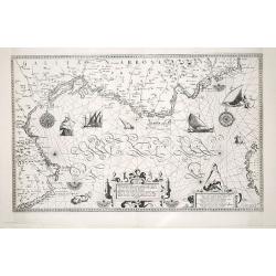
(Sea-chart of Catalunia, Languedoc, Provence, Cote d'Azur, Riviera, Corsica with Marseille, Cannes, Nice, Monaco.)
This very rare chart is important as the first printed sea chart of France's Mediterranean coast, also depicting Catalunya's northern coast, the Italian Cote d'Azur till ...
Place & Date: Amsterdam, 1607
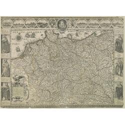
Germania.
Second state of this rare "carte à figures"- map of Germany, The Netherlands, Poland and central Europe. Bordered on three sides with portraits and views. In t...
Place & Date: Amsterdam, 1607

Polus Arcticus cum vicinis regionibus.
Map of the North Pole regions from the 1608 second edition of Jodocus Hondius' Atlas Minor.A reduction of the 1606 Mercator-Hondius folio map (which is a later state of t...
Place & Date: Amsterdam, 1608
![[Title page for] Atlas Minor de Guerard Mercator. . .](/uploads/cache/47933-250x250.jpg)
[Title page for] Atlas Minor de Guerard Mercator. . .
Title page from a 1608 French edition of the Atlas Minor (351:11). The title page is similar to that in the Latin edition of 1607, but a slip of paper with the engraved t...
Place & Date: Amsterdam, 1608

Delineatio Civitatis et Castelli Amboinae.
Early view of Ambon, with 6 Dutch vessels offshore.Theodore de Bry, a German engraver and book dealer, began a compilation of early voyages in 1590 and had published six ...
Place & Date: Frankfurt, 1609
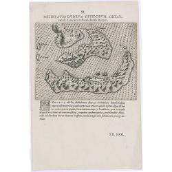
Delineatio Duorum Oppidorum, Ortat.
Early map of the Banda Islands.Theodore de Bry, a German engraver and book dealer, began a compilation of early voyages in 1590 and had published six parts at the time of...
Place & Date: Frankfurt, 1609
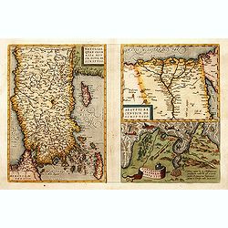
1) Natoliae,.. 2) Aegypti recentior.. 3) Carthaginis..
To the left a map of Turkey. Oriented with west at bottom. Right side of sheet contains a map of northern Egypt showing the Nile River delta, and a map the vicinity of Tu...
Place & Date: Antwerp, 1570-1609
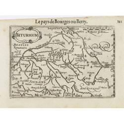
Biturigum.
A miniature map of the Berry. Fine cartouche in the upper left corner.First published in 1598 in his Caert-Thresoor, the plates were executed by the most famous engravers...
Place & Date: Amsterdam/Frankfurt 1609
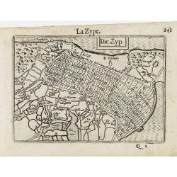
Die Zyp / La Zype.
A miniature map showing the polder of De Zype. Title cartouche in the upper side.First published in 1598 in his Caert-Thresoor, the plates were executed by the most famou...
Place & Date: Amsterdam / Frankfurt, 1609
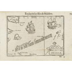
Maldivae Insulae.
Very fine early miniature map of Maldives Islands. East is at the top. Title cartouche on the lower right corner. A dolphin and two ships are depicted.First published in ...
Place & Date: Amsterdam / Frankfurt, 1609
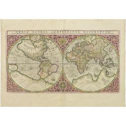
Orbis Terrae Compendiosa Descriptio.
Gerard Mercator's great world map of 1569 was condensed into double hemispherical form by his son Rumold. It first appeared in 1587 in Casaubon's edition of Strabo's Geog...
Place & Date: Amsterdam, 1595-1609
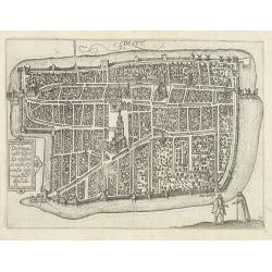
![[Bantam].](/uploads/cache/37970-250x250.jpg)
[Bantam].
Text engravings from "Premier livre de l'histoire de la navigation aux Indes Orientales, par les hollandois, et des choses a eux advenues . . . ", being the cla...
Place & Date: Amsterdam, Cornille Nicolas, 1609
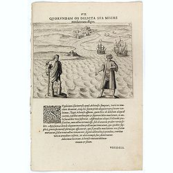
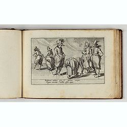
VII. Quorundam ob Delicta sua misere mutilatorum effigies.
This shows Sebald van de Weert, the Dutch sailor who emerged from the Magellan Straits in 1600 and spotted the rocky islands off the coast of South America. For most of t...
Place & Date: Frankfurt, 1609
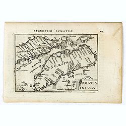
Sumatra Insula.
A miniature map of Sumatra and the Malay Peninsula, including Singapore and the various islands directly south of it. Containing detailed geography and nomenclature aroun...
Place & Date: Amsterdam, 1609
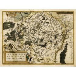
Lutzenburgensis Ducatus veriss descript.
Prepared by Jacob Surhon who made a manuscript map of Luxembourg for which he received 500 Livres from Charles V in 1551. For security reasons the map was not published. ...
Place & Date: Antwerp, 1609
Limburgensis Ducatus Tabula Nova.
Map of Limburg, prepared by the Antwerp expert in law and mathematics Aegidius Martini. After 1600 Jan Baptist Vrients acquired the stock and the plates of Ortelius' Thea...
Place & Date: Antwerp, 1606-1612
Cruydt-Boeck van Remberus Dodonaeus. . .
Scarce, the last edition of Dodoens' Cruydt-Boeck, one of the most influential and important botanical works of the 16th and 17th centuries. With richly engraved frontisp...
Place & Date: Leyden, 1612
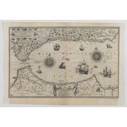
Hydrograhica descriptio
This very rare chart is important as the first printed sea chart of the Mediterranean coast of Spain, Gibraltar, also depicting the northern coast of Marocco.Willem Bar...
Place & Date: Amsterdam, W.Blaeu, 1612
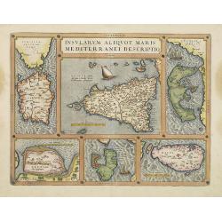
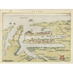
Sardinia / Sicilia.. / Corfu / Zerbi.. / Elba / Malta. . .
Six very fine and early maps on one sheet. Including the islands of Sicily, Corfu, Sardinia, Zerbi (Djerba), Elba and Malta.The map of Malta has a sinking ship at Cala di...
Place & Date: Antwerp, 1570-1612
Ruremunda Gelriae opp.
A bird's eye town-plan of the town of Roermond. From the first Dutch translation of Guicciardini's description of the Netherlands.
Place & Date: Amsterdam, 1612
DELFT. Delphium urbs Hollandiae cultissima. . .
A bird's-eye view of the town of Delft. From the first Dutch translation of Guicciardini's description of the Netherlands. In this town-plan, three buildings, still domin...
Place & Date: Amsterdam, 1612
![[Title page colored by Georg Mack Jr. to : Hortus Eystettensis, Sive Diligens et Accurata Omnium Plantarum, Florum, Stirpium,. . .]](/uploads/cache/39343-250x250.jpg)
[Title page colored by Georg Mack Jr. to : Hortus Eystettensis, Sive Diligens et Accurata Omnium Plantarum, Florum, Stirpium,. . .]
Title page to the first edition, one of about 300 copies printed, from one of the largest and most magnificent of the great flower books, depicting more than 1000 flowers...
Place & Date: Nuremberg, ca 1613
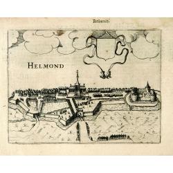
Helmond.
A panoramic view of the Helmond, seen from the Kromme Steenweg .
Place & Date: Arnhem, 1613
Nieuw Nederlandtsch Caertboeck. Waer in volkomentlijcker als oyt te voren vertoont werden de XVII. Nederlanden.
Rare first edition of this atlas of the provinces of the Netherlands, Belgium and Luxemburg. Engraved title page, with : "Gedruckt t' Amsterdam by Abraham Goos Plaet...
Place & Date: Amsterdam, 1616
Deliciae Batavicae.
It is a charming book illustrated with portraits of Willem of Orange and Prince Maurits and eight engraved armorial plates. Followed by 30 engraved views or scenes of ...
Place & Date: Amsterdam, Johannes Janssonius, 1618
Frisia occidentalis.
A rare separately published carte-a-figures of Friesland by Geelkercken in its first state. The title and the coats of arms of the eleven Frisian towns appear in the cent...
Place & Date: [Leeuwarden], Dierick Albertsen, 1618
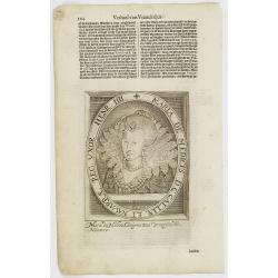
Maria De Medices D. G Galliae et Navarrae Reg. Uxor Henr. IIII.
The engraving depicts a half length oval portrait of Marie de' Medici, queen consort of France .Nicolaes de Clerck (de Klerc) was active as engraver and publisher in Delf...
Place & Date: Amsterdam, Cloppenburch, 1621
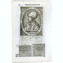
Solimannus Turcarum Imperator X. Ex Stirpe Ottomannicae.
The engraving depicts a half length oval portrait of "Solimannus Turcarum Imperator X", signed lower right corner N. de Cleck". Nicolaes de Clerck (de kler...
Place & Date: Amsterdam, Cloppenburch, 1621
Angliae, Scotiae, et Hiberniae, sive Britannicar : Insularum descriptio.
A rare and ornate map with inset portraits of James First, Henry Prince of Wales Princess Anne of Denmark.Janssonius acquired the copperplate of van den Keere's 1604 Brit...
Place & Date: Amsterdam, 1621
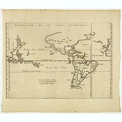
Descripcion de las Yndias Ocidentalis.
Rare early general map of America, the Pacific Ocean and the Eastern part of Asia. Showing "Meridiano de la demarcacion porla parte oscidental" - and "... ...
Place & Date: Amsterdam, Michel Colin, 1622
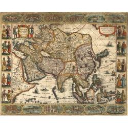
Asia recens summa cura delineata.
This is the rare early issue with decorative paneled borders of four sides. It is surrounded by elaborate borders incorporating twelve bird's eye views of cities and te...
Place & Date: Amsterdam, H.Hondius,1623
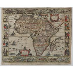
Africae nova Tabula.
A second state of this very rare "carte à figures"- map. Decorated with the four decorative borders by Jodocus Hondius Jr.This remarkable map of Africa was fir...
Place & Date: Amsterdam, 1623

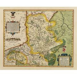
Marchionatus Sacri Romani Imperii.
Plan of the city of Antwerp in Belgium, by Claes Janszoon Visscher and first published by his son. The map is surrounded by 3 city views and 10 building vignettes and inc...
Place & Date: Amsterdam 1624
Typus Frisiae Orientalis à Dullarto
One of the most decorative maps of East Frisia and its important shipping center of Emden and the Watten Islands, from the cartography of Ubbo Emmius, a local cartographe...
Place & Date: Amsterdam, ca. 1624
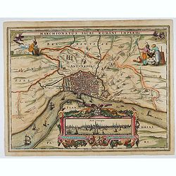
Marchionatus Sacri Romani Imperii.
A wonderfully decorative map showing in the middle of the image a town plan from Antwerp and in the lower part an inset with a panoramic view of the city and harbour of A...
Place & Date: Amsterdam, 1617- 1624
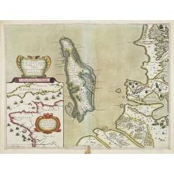
Malta.
Attractive birds-eye town-view of Valetta on Malta. With coat of arms lower right. With page number 398 in top. Latin text on verso.From "Nova et accurate Italiae ho...
Place & Date: Amsterdam, 1626
![Summa philosophiae quadripartita, de rebus dialecticis, moralibus et metaphysicis . . [ With unrecorded world map ]](/uploads/cache/28639-250x250.jpg)
Summa philosophiae quadripartita, de rebus dialecticis, moralibus et metaphysicis . . [ With unrecorded world map ]
On page 107 a finely copper engraved world map (88x84mm.) Paradigma Terrae Plagas 4.ac 12. Ventorum situm indicans., centered on Europe and Africa, with parts of America,...
Place & Date: Leiden, Peter Rigaud, 1626
Carte de la Coste de La Rochelle a Brouaige et de l'Isle d'Oleron Observee par le S.r de Chattillon ingenieur du Roy.
Map of the island of Oléron, with an inset in lower left corner showing the route of an English fleet to La Rochelle. At the time of mapping the area was a stronghold of...
Place & Date: Paris, 1627
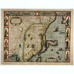
The Kingdome of China.
A most sought-after map of China. Decorative border vignettes including views of the cities of Quinzay and Macao along the top border with the wheeled wind machines and p...
Place & Date: London, G. Humble, 1627
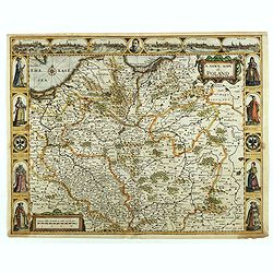
A Newe mape of Poland Done into English by I.Speede.
A wonderful map of Poland. Incorporated into Speed's 'Prospect Of The Most Famous Parts Of The World.' Includes birds-eye views of Cracow, Dantzick, Posna, Crossen, Sando...
Place & Date: London, 1627

A Newe mape of Poland Done into English by I.Speede.
A wonderful map of Poland. Incorporated into Speed's 'Prospect Of The Most Famous Parts Of The World'. Includes birds-eye views of Cracow, Dantzick, Posna, Crossen, Sando...
Place & Date: London, 1627
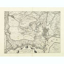
Kaerte van Bergen op Zoom, Steenbergen ende de nieuwe fortificatien gemaeckt tot bevrÿdinge van 't landt van ter Tolen in tjaar 1628.
Very detailed and scarce map showing Bergen Op Zoom, Steenbergen and its surrounding countryside. North to the left side.
Place & Date: Amsterdam, after 1628
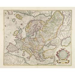
Europa, ad magnae Europae Gerardi Mercatoris. . .
General map of Europe, as well as Americae Pars, Greenland, Iceland, a Polar landmass, along with the mythical islands of Frisland, Drogeo, and Bradain. A large strapwor...
Place & Date: Amsterdam, 1628
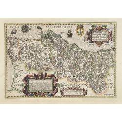
Portugalliae que olim Lusitania..
The best-known map of Portugal, after Alvares Secco (1560), orientated west to the top of the sheet. Secco's map was copied by many mapmakers and publishers for upwards o...
Place & Date: Amsterdam, 1628
Set of four continents.
Fine set of 4 continents prepared by Gerard Mercator. The general map of Europe, as well as Americae Pars, Greenland, Iceland, a Polar landmass, along with the mythical i...
Place & Date: Amsterdam, 1628
![Figure 38 troisieme partie. [Hors riding]](/uploads/cache/14164-250x250.jpg)
Figure 38 troisieme partie. [Hors riding]
This fabulous illustration depicts formal movements of equitation for horse riding school movements. The print shows both A.de Pluvinel and the future King at the age of ...
Place & Date: Paris, 1629
![Figure 27 deuxieme partie a gauche.. [Hors riding].](/uploads/cache/14160-250x250.jpg)
Figure 27 deuxieme partie a gauche.. [Hors riding].
This fabulous illustration depicts formal movements of equitation for horse riding school movements. The print shows both A.de Pluvinel and the future King at the age of ...
Place & Date: Paris, 1629
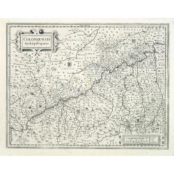
Coloniensis Archiepisscopatus.
Extremely rare first edition of this beautiful map of Cologne and Dusseldorff.Jodocus Hondius Jr. planned to produce a new modern atlas less dependent on the Mercator pla...
Place & Date: Amsterdam, 1629
Valletta citta nova dimalta.
Early copper engraved map of the towns of Valletta, Borgo, Sanglea di Sto. Michele, and the church of St. Salvator -known as the Three Cities., engraved by Henry Raignaul...
Place & Date: Paris, Michael Soly, 1629
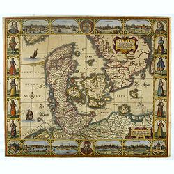
Daniae Regni Typum..
A first state. Very decorative "carte à figures"- map of Denmark with the signature of the engraver Abraham Goos. Printed on heavy paper, in spite of its repai...
Place & Date: Amsterdam, 1629

India Orientalis.
Published in Hondius' editions of the Mercator Atlas from 1606 onwards, showing the Indian subcontinent, the Malay Peninsula, Siam and Cambodia, China and the Philippines...
Place & Date: Amsterdam, 1630

Pas-Caert vande ghelegetheyt vande Schans te Santvliet, Vertoonede de verdroncken overwaeterde Landen, nieuw aengewasse gorsingen,. . .
Showing the surrounding countryside of the cities of Antwerp, Santvliet, Lillo, Bergen op zoom, etc. The map is ponctuated by several fortifications to indicate the main ...
Place & Date: Amsterdam, 1630
![Tabula electoratus Brandenburgici, Meckelenburgi, et maximae partis Pomeraniae, ex variis, famosissimisq[ue] auctoribus summo studio concinnata. . .](/uploads/cache/37545-250x250.jpg)
Tabula electoratus Brandenburgici, Meckelenburgi, et maximae partis Pomeraniae, ex variis, famosissimisq[ue] auctoribus summo studio concinnata. . .
Uncommon "carte à figures"- map engraved by the master engraver Abraham Goos and published by Claes Jansz. Visscher (1587-1652). The map shows the part of west...
Place & Date: Amsterdam, 1630
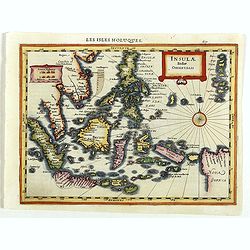
Insulae Indiae Orientalis.
Map of South East Asia with good detail on the Philippines from the rare Cloppenburg edition slightly larger format and more scarce edition of the Mercator/Hondius "...
Place & Date: Amsterdam, 1630

Cornubia, Devonia, Somersetus, . . .
A very nice map showing the south-western part of England. Mercator was born in Rupelmonde in Flanders and studied in Louvain under Gemma Frisius, Dutch writer, astronome...
Place & Date: Amsterdam, 1630
Selling price: $400
Sold in 2025
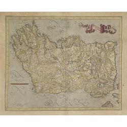
Irlandiae Regnum.
A very nice map from Ireland.Mercator was born in Rupelmonde in Flanders and studied in Louvain under Gemma Frisius, Dutch writer, astronomer and mathematician. The excel...
Place & Date: Amsterdam, 1630

Comitatus Flandria.
First published by the van Langrens c.1595, after his acquisition of the plate, Visscher heavily re-engraved the map, inserting panelled borders on three sides (the lower...
Place & Date: Amsterdam, c. 1630
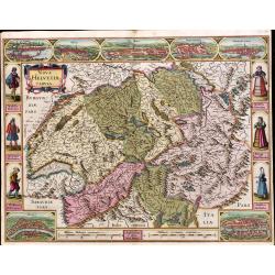
Nova Helvetiae Tabula.
A most decorative "carte à figures" map with panoramic views of Lucern, S.Gal, Bern, Solothurn, Schafhausen in upper border and Basel and Zurich in lower left ...
Place & Date: Amsterdam, 1630
![Tabula electoratus Brandenburgici, Meckelenburgi, et maximae partis Pomeraniae, ex variis, famosissimisq[ue] auctoribus summo studio concinnata. . .](/uploads/cache/29543-250x250.jpg)
Tabula electoratus Brandenburgici, Meckelenburgi, et maximae partis Pomeraniae, ex variis, famosissimisq[ue] auctoribus summo studio concinnata. . .
Uncommon "carte à figures"- map engraved by the master engraver Abraham Goos and published by Claes Jansz. Visscher (1587-1652). Showing the area of Brandenbur...
Place & Date: Amsterdam, 1630
Romani Imperii Imago.
Very rare map in a first edition by Jacques Honervogt. Copied after a map by Ortelius but much rarer. The medallion portraits are of Romulus and Remus - the genealogical ...
Place & Date: Paris, 1630