Browse Listings
![[A collection of 100 Soviet propaganda poster published in the 1980's]](/uploads/cache/47076-250x250.jpg)
[A collection of 100 Soviet propaganda poster published in the 1980's]
A collection of 100 Soviet propaganda posters published during the early years of the Perestroika & Glasnost period. Most posters are made by Plakat (All-Union Poster...
Place & Date: Moscow, ca. 1980-1989
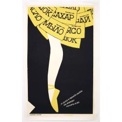
Russian Perestroika Ballet Poster.
Wonderful and delicate Russian Perestroika poster depicting a ballerina. On the frills of her skirt, there are several messages written down, which mean « a coupon for s...
Place & Date: Russia, 1990
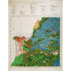
Carte géologique détaillée. Beyrouth.
Geological or soil map showing part of Lebanon with Beyrouth, including in top a colored legend with signs of the different geological ages. Provenance : Fondation P. Fal...
Place & Date: Liban, Service geographique des F.F.L., 1945.
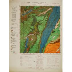
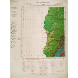
Carte géologique détaillée. Jezzîne.
Geological or soil map showing part of Lebanon with Jezzîne, including a legend with signs of the different geological ages and giving many information of greatest inter...
Place & Date: Liban, Service geographique des F.F.L., 1945.
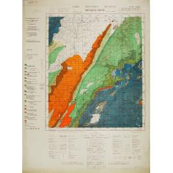
Carte géologique détaillée. Râchaïya Nord.
Geological or soil map showing part of Lebanon with Râchaïya , including a legend with signs of the different geological ages and giving many informations of greatest i...
Place & Date: Liban, Service geographique des F.F.L., 1945.
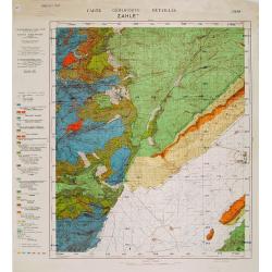
Carte géologique détaillée. Zahle.
Geological map showing part of Lebanon with Zahle. , including a legend with signs of the different geological ages. Provenance : Fondation P. Fallot
Place & Date: Liban, Service geographique des F.F.L., 1945.
Carte geologique detaillee. Jbail.
Geological or soil map showing part of Lebanon with Jbail antique Byblos Ancien Port phenicien / scale 1 : 50 000., including a legend with signs of the different geologi...
Place & Date: Liban, Service geographique des F.F.L., 1945.
![[Title page for] Theatrum Orbis Terrarum.](/uploads/cache/47940-250x250.jpg)
[Title page for] Theatrum Orbis Terrarum.
A decorative title page of the first atlas ever made shows five female figures as allegorical representatives of the continents, grouped around the title. According to P...
Place & Date: Antwerp, 1570 or later.