Browse Listings in Europe > Russia / Baltic / Black Sea region > Ukraine / Black Sea
![[Europe, Eastern, Sarmatia, Ukraine]](/uploads/cache/33854-250x250.jpg)
[Europe, Eastern, Sarmatia, Ukraine]
Wood block printed map and one of earliest printed representation of Europe, Eastern, Sarmatia, Ukraine prepared L. Fries after Martin Waldseemüller.Based on the slightl...
Place & Date: Vienna, Trechsel, G., 1525 -1541
![.[Georgia (Republic), Sarmatia, Ukraine]](/uploads/cache/33870-250x250.jpg)
.[Georgia (Republic), Sarmatia, Ukraine]
Wood block printed map and one of earliest printed representation of Georgia (Republic), Sarmatia, Ukraine prepared by Martin Waldseemüller. Based on the slightly larger...
Place & Date: Vienna, Trechsel, G., 1525 -1541
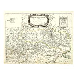
LA RUSSIE ROUGE ou POLONOISE qui Comprend les PROVINCES DE LA RUSSIE ROUGE de VOLHYNIE et de PODOLIE divisées en leurs Palatinats Vulgairement Connües sous le Nom D'VKRAINE ou PAYS DES COSAQUES.
A very rare Sanson map of Ukraine and so-called Russie Rouge, stretching from Lublin in the west to Kherson Oblast in the east (here called "Confin de La Petite Tart...
Place & Date: Paris, 1706
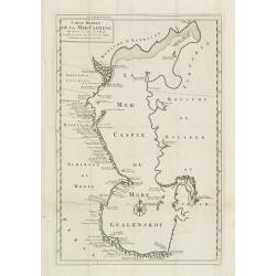
Carte Marine De La Mer Caspiene levée suivant les ordres de S.M.Cz. En 1719, 1720 et 1721.
Detailed of the Caspian Sea, prepared by Karl van Verden in 1722. Van Verden was a Russian sailor and the Czar's Special Commander, who produced the first accurate map of...
Place & Date: Paris, ca. 1725
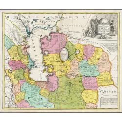
Nova Maris Caspii et Regionis Usbeck cum Provincijs adjacentibus vera Delineatio
This is the first printed map specifically of the Uzbek region. The map shows the area around the Caspian Sea and northern Iran. The earea eastwards from the Caspian is m...
Place & Date: Nuremberg, 1735
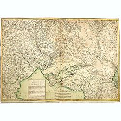
Nouveau théâtre de la guerre entre les Russes les turcs et les polonois confédérés.
A very rare separately published map of Crime region. With a large title cartouche lower left "Nouveau theâtre de la guerre entre les russes, les turcs et les polon...
Place & Date: Paris, 1769
![[Crimea]. Carte de la Cromée.](/uploads/cache/25719-250x250.jpg)
[Crimea]. Carte de la Cromée.
Mapmaker, Captain Jan Hendrik van Kinsbergen (1735-1819). Published by H. Friesman in 1787. This map first appeared in 1776 and was the first Russian map of the newly ann...
Place & Date: Amsterdam, H. Frieseman, 1787
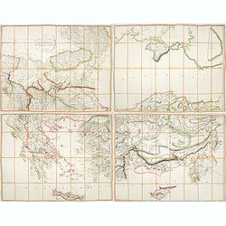
A Map of the Environs of Constantinople Drawn from a great number of accurate astronomical & geographical manuscripts and printed documents, by A. Arrowsmith 1801 and 1804.
Arrowsmith’s large and detailed map of the Ottoman Empire and the Black Sea, with Cyprus, Crete and the Greek Islands in the Mediterranean Sea, Albania, Bosnia and Herz...
Place & Date: London, No.10 Soho Square, 4th September 1804
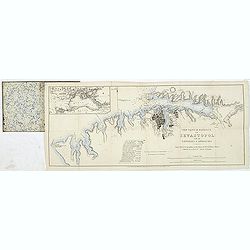
The town & harbour of Sevastopol with the batteries & approaches. . .
Rare colored linen backed map showing the harbour and town of Sevastopol, with soundings. In upper left corner a inset map (65x150mm) of the Black Sea. In bottom part a l...
Place & Date: London, March 27th, 1854
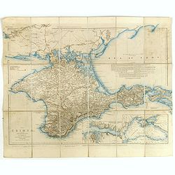
The Crimea, chiefly from surveys made by order of the Russian government. . .
Map of Crimea and the Sea of Azov. In lower right corner two inset maps showing Sebastopol inlet and harbour and a second one with the Black Sea. This second maps shows t...
Place & Date: London, 1854
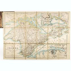
The Crimea by James Wyld Geographer to the Queen & H.R.H. Prince Albert.
Fourth edition of this folding map of the Crimea. In upper right corner an inset map of the areas around the Black Sea; "The Town & Harbor of Sevastopol with the...
Place & Date: London, 1855
Military map of the countries between Odessa & Perekop with the stations of the Russian forces.
Rare colored linen-backed map showing Russian troop positions and Odessa Batteries. On the inside of the cover a list of "Wyld's list of recent publications : seat o...
Place & Date: London, ca. 1855
Provincie ecclesiastiche di Leopoli e Fogaras ed Altre Diocesi di Rito Greco (Tav LXXV)
This large-format Romania map is finely engraved and beautifully colored and was prepared by Girolamo Petri, a lawyer who served as a senior official within the Vatican�...
Place & Date: Rome, 1858
Selling price: $250
Sold in 2025
![[Lot of 9 maps] Plan général de Sébastopol avec indication des travaux du siege et de la defense au 28 mars - 9 avril 1855. Feuille 10. xiii](/uploads/cache/33907-250x250.jpg)
[Lot of 9 maps] Plan général de Sébastopol avec indication des travaux du siege et de la defense au 28 mars - 9 avril 1855. Feuille 10. xiii
A group of nine (of 14) very rare panoramic town-plans of the siege of Sebastopol or maps of the Crimea. In lower margin : "Gravé au Dépôt topographique de la Gue...
Place & Date: St. Petersburg, N. Thieblin, 1863