Browse Listings in Europe
![[Cloth Map of Europe]](/uploads/cache/47148-250x250.jpg)
[Cloth Map of Europe]
Anglo-centric cloth map of Europe produced during WWI.Serbia, the spark that lit the conflagration of World War One, isn’t even labeled on this interesting cloth map of...
Place & Date: London, c. 1915
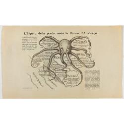
L'Impero della preda ossia la Piovra d'Absburgo.
Austro-Hungarian Octopus zinc lithographed map. A propaganda sheet attacking the Austro-Hungarian Empire, showing it as an octopus with its tentacles wrapped around the v...
Place & Date: La Zincografia, Milan, c. 1915
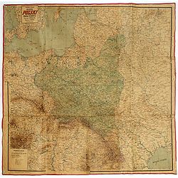
Mapa Polski i Krajów Osciennych - Wydanie trzecie. Opracowal Stanislaw Max. Wydani M. Arcta.
‘The Birth of Modern Poland on a map’ - an excellent wall map of Poland and surrounding regions, published in Warsaw near the end of World War I, when Poland’s fate...
Place & Date: Warsaw, [H. Sklodowski], 1918
![[This is Great Brittain to-day - Cambridge]](/uploads/cache/43009-250x250.jpg)
[This is Great Brittain to-day - Cambridge]
Chromolithoghraphed plate showing a fancy depiction of the courtyard of a British University (Cambridge). A text in Arabic language explaining about the 20 universities a...
Place & Date: Arabia, ca. 1920
Selling price: $360
Sold in 2025
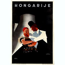
Hongarije.
Poster made for Hungarian Tourist association. The uncommon Dutch version of this fine poster to promote Hungary in the 1930's. Arisztid Uher was a graphic designer. He d...
Place & Date: Budapest, KLOSZ / Sohn., ca. 1930

(Art déco gouache with winter scene of The Palace of Westminster )
Outstanding "art deco" gouache (unsigned) from the workshop of "Robert Pichon. Ateliers de Dessin et Lithographie – 10, rue Rochechouart – Paris. The ...
Place & Date: Paris, ca. 1930
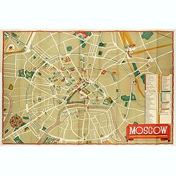
Moscow.
Fantastic pictorial map of Moscow designed to draw tourists to the new Soviet Union.The cultural vitality of Moscow in the early years of the Soviet Union is the focal po...
Place & Date: Moscow, c. 1938
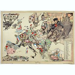
L'Europe en Sept 1939. Ille terrarum mihi angulus ridet.
A rare oversized serio-comic map of Europe at the start of the Second World War depicting stereotypes of 31 countries, as listed in the key lower right, including Brit...
Place & Date: Bruges, Leon Burghgraeve, 1939
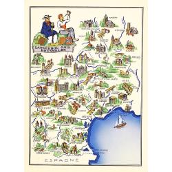
Languedoc - Foix Roussillon.
Very decorative, informative map of Languedoc - Foix Roussillon region in south eastern France. Including the towns of Carcassonne, Montpellier, Albi, Toulouse, etc.The m...
Place & Date: France, 1943
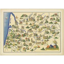
Guyenne - Gascogne.
Very decorative, informative map of Guyenne and Gascogne region in France. The map is filled with buildings, animals, figures and two locals. With a large compass rose in...
Place & Date: France, 1943
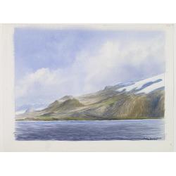
Group of 21 watercolors of scenes in Iceland, included are vulcanos like Eyjafjallajokull, Öræfajökull, etc.
A group of water colors made during visits of the artist F. de Boungne to Iceland, among them are contemporary artistic impressions of the now world-famous volcano Eyjafj...
Place & Date: Iceland, 1933-1944
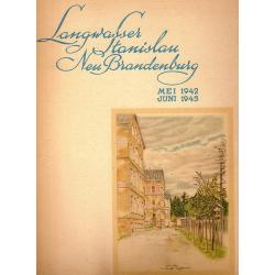
Langwasser Stanislau Neu Brandenburg Mei 1942 Juni 1945
Map met reproducties van crayontekeningen van Krijgsgevangenschap in Langwasser, Stanislau en Neu-Brandenburg, Mei 1942 -juni 1945.Uitgegeven april 1948 door het Minister...
Place & Date: Den Haag, April 1948
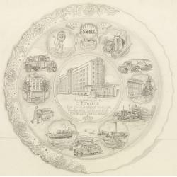
Shell : 9 Februari 1911-1951.
Decorative design-drawing in lead pencil offered to mr. J.E. Talens for his 40 years jubilee at the Shell foundation : Aangeboden aan J. E. Talens ter gelegenheid van zij...
Place & Date: Gouda, ca. 1951
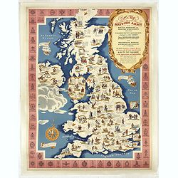
A map of the British Army with battle honours and militray achievements and Regimental Badges . . .
Shows English County Regiments, Battle Honours and Military Achievements. Bordered by Regimental Badges.A fascinating piece of British history.Read more about Pictorial M...
Place & Date: London, 1952
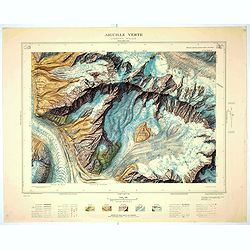
Aiguille verte - Chamonix N°6 Sud
Magnificent 1:10,000 scale color printed map of l'Aiguille verte (Chamonix N°6 Sud) based on stereotopographic ground and aerial surveys carried out in the field in 1950...
Place & Date: Paris, 1953
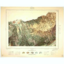
Servoz - Cluses N°8 Sud.
Magnificent 1:10,000 scale color printed map of Servoz (Cluses N°8 Sud) based on stereotopographic ground and aerial surveys carried out in the field in 1950 and render...
Place & Date: Paris, 1953
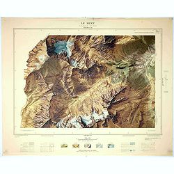
Le Buet - Chamonix N°1 Sud. / Massif des Aiguillles Rouges.
Magnificent 1:10,000 scale color printed map of Le Buet (Chamonix No. 1 South) / "Massif des Aiguilles Rouges" based on stereotopographic ground and aerial surv...
Place & Date: Paris, 1953
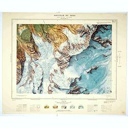
Aiguille du Midi - Mont Blanc N°1 Nord.
Magnificent 1:10,000 scale color printed map of L'Aiguille du Midi (Mont Blanc N°1 Nord) based on stereotopographic ground and aerial surveys carried out in the field in...
Place & Date: Paris, 1953
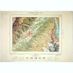
Chamonix - Mont Blanc - Chamonix N°5 Sud.
Magnificent 1:10,000 scale color printed map of Chamonix - Mont Blanc (Chamonix N°5 Sud) based on stereotopographic ground and aerial surveys carried out in the field in...
Place & Date: Paris, 1953
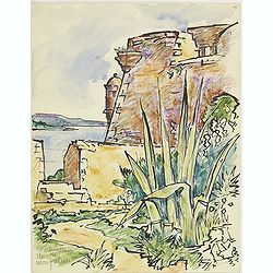
Forteresse Ile Ste Marguerite.
Nice drawing of a stronghold Ste Marguerite. The Île Sainte-Marguerite is the largest of the Lérins Islands, about half a mile off shore from the French Riviera town of...
Place & Date: France, Provence, after 1960
![[Fan shaped shopping guide to Stockholm.]](/uploads/cache/44788-250x250.jpg)
[Fan shaped shopping guide to Stockholm.]
A highly unusual and interesting vintage fan-shaped map of Stockholm to illustrate a 'Shopping guide to Stockholm'. Text written in English. With ten fold-out panels prin...
Place & Date: Stockholm, 1960
![[Pictorial map of Georgia (Caucasus)].](/uploads/cache/47135-250x250.jpg)
[Pictorial map of Georgia (Caucasus)].
A scarce pictorial map of a region in Georgia in the Caucasus. Map is entirely in Russian, complete with legend at base of map, with small thumbnail pictures and symbols ...
Place & Date: Moscow, 1963
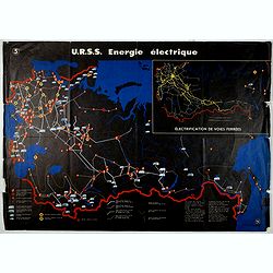
U.R.S.S. Energie Eléctrique. (5)
Map of Russia. Publicity poster for Russia's electrical production. Text in French. Editions de l'Agence de presse Novosti".More about War Maps & Propaganda maps...
Place & Date: USSR, 1978