Browse Listings in East Meets West > Silk Road

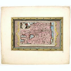
Russiae, Moscoviae et Tartariae Descriptio.
Engraved by Frans Hogenberg from an original of 1562 by Anthony Jenkinson of the English Muscovy Company. The many vignettes are based on the reports of Marco Polo's expl...
Place & Date: Antwerp, 1598
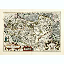
Tartaria.
Published in Hondius' editions of the Mercator Atlas from 1606 onwards, China, Korea, and the northern Pacific coast of America are shown as two continents separated by t...
Place & Date: Amsterdam, 1633
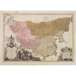
Historic Map - Naaukeurige Kaart Van Tartaryen, Soo als dat door W De Rubruquis doorreyst.
This attractive map published by Pieter van der Aa, shows Tartary abd the ancient Silk Road region. The map shows the track of William of Rubruck (Willem van Rubroeck or ...
Place & Date: Amsterdam, 1713-1729

Oriens, Persia, India etc.
Uncommon map of Persia, Armenia, Arabian Peninsular and part of India. Prepared by Christoph Cellarius (1638-1707). From Geographia Antiqua...
Place & Date: Leipzig, Gledisch, 1732
Carte la plus generale et qui comprend la Chine, la Tartarie chinoise et le Thibet. . .
It has a quite elaborate pictorial cartouche engraved by G. Kondet. It is a very detailed map of China, Tibet, and Korea.In the upper left corner is very good details of ...
Place & Date: The Hague, 1737