Browse Listings
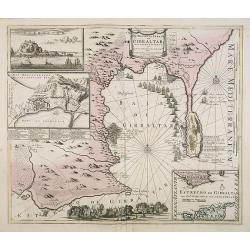
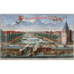
De Haven en Straat von Gibraltar, Niewlyks getekend, en in`t licht gebracht door Johannes Covens en Cornelis Mortier tot Amsterdam.
Decorative map showing the siege of Gibraltar during the Spanish war of succession. This highly interesting map is richly ornated with three additional inset maps and vie...
Place & Date: Amsterdam, 1710
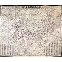
Nansenbushu bankoku shoka no zu.
This wall-map is a great example of Japanese world maps representing Buddhist cosmology with real-world cartography. It is the earliest one and - therefore - the prototyp...
Place & Date: Kyoto, (Hoei 7 = Year of the Tiger) 1710
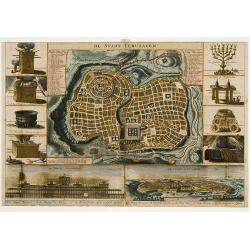
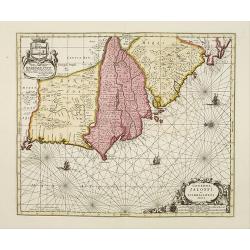
De Stadt Jerusalem.
Plan of ancient Jerusalem from a Dutch bible after Villalpando. The print is in contemporary colors, which is extremely rare for a plate like this. Lower left the Temple ...
Place & Date: Amsterdam, 1710
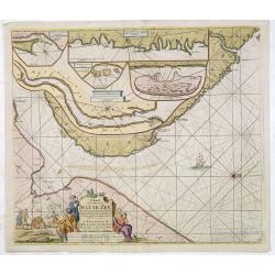
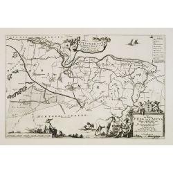
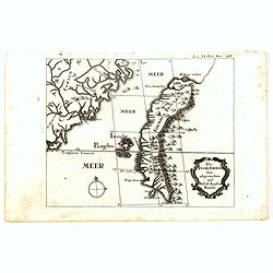
.Paskaart van de Mont van de Witte Zee,. Beginnende van Tiepena tot Pelitza, als mede van C. Cindenoes tot Catsnoes.
Fine sea chart of the southern part of the Barents Sea, oriented to the West. With five inset maps: - Swetenoes, de Kust van Laplandt, Lombascho, 'T Vaste Landt van Lapla...
Place & Date: Amsterdam, c.1710
![[A magnificent 18 inch. (46 cm.) diameter celestial globe] URANOGRAPHIA / SYDERUM ET STELLARUM / in Singulis Syderibus conspicuarum / exhibens Delineationem accuratissimam, / qua / ex Observationibus Astronomi plane Singularis / IOHANIS HEVELII...](/uploads/cache/48959-250x250.jpg)
[A magnificent 18 inch. (46 cm.) diameter celestial globe] URANOGRAPHIA / SYDERUM ET STELLARUM / in Singulis Syderibus conspicuarum / exhibens Delineationem accuratissimam, / qua / ex Observationibus Astronomi plane Singularis / IOHANIS HEVELII...
RARE FIRST STATE OF THIS CELESTIAL TABLE GLOBE, 46 cm in diameter, produced by Gerard and Leonard Valk at the beginning of the 18th century. The globe comprises of t...
Place & Date: Amsterdam, 1711
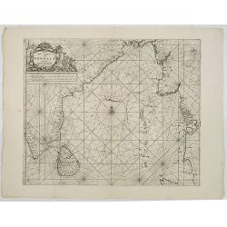
De golf van Bengalen.
Rare chart of the Indian Ocean, with nice detail on Ceylon (Sri Lanka) with compass roses and a system of rhumb lines, soundings and anchorage's. Many place names. The pl...
Place & Date: Amsterdam, after 1669-1712

Le détroit de Malacca . . .
Map of Malacca. The map details the Strait of Malacca from P. Peru and Tanjong Goeree to Lingen and Pulu Panjang. Malacca and Ihor (Johore), along with numerous other coa...
Place & Date: Leiden, 1712
![[Title page] Le Nouveau Theatre du Monde.](/uploads/cache/47951-250x250.jpg)
[Title page] Le Nouveau Theatre du Monde.
The fine engraved frontispiece by F. Bleiswyk entitled "Le Nouveau Theatre du Monde" for Pieter van der AA. Shows Atlas carrying the world on his shoulders acco...
Place & Date: Leiden, 1713
A new and correct map of the world.
The early eighteenth century was one of the most important periods for English cartography. One of the period's most intriguing world maps is this large-scale map, which ...
Place & Date: London 1714

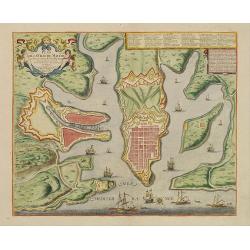
Plan de Palma ville capitalle de l'Isle de Majorque.
Bird's eye-view of Palma de Majorca. Wind rose in the lower left corner. Nicolas de Fer [1646-1720] was one of the most prolific and influential French geographers and ca...
Place & Date: Paris, 1715
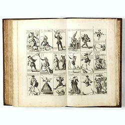
![Recueil de costumes. Imagini degl'abiti con cui Va uestita la Nobiltà della Serenis.ma Republica di Venezia. Suivi de: [Augsburger Kleidertrachten].](/uploads/cache/48425-250x250.jpg)
Recueil de costumes. Imagini degl'abiti con cui Va uestita la Nobiltà della Serenis.ma Republica di Venezia. Suivi de: [Augsburger Kleidertrachten].
Imagini degl'abiti con cui Va uestita la Nobiltà della Serenis.ma Republica di Venezia. Dedicate all'Illmo et Ecc.mo Sig.r Andrea da Leze Degnis.mo Proc.tor di S: Marco....
Place & Date: Venezia, Ragheno, 1702 / Augsbourg, J. Wolff, ca. 1715
![[Title page] La Sphere Royale.](/uploads/cache/48022-250x250.jpg)
[Title page] La Sphere Royale.
Title page from Nicolas de Fers "La Sphere Royale", published in 1717. Showing a sphere, surrounded by Neptune, Europe, the elements and scholars.
Place & Date: Paris, 1717
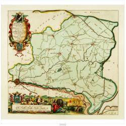
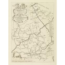
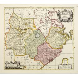
Dongerdeel.. De vierde grietenij van Ooster Goo.
Very decorative map centered on Dokkum, Metzerwier, and Pasens from the Uitbeelding der Heerlijkheit Friesland prepared by Schotanus. With decorative title cartouche lowe...
Place & Date: Leeuwarden, F.Halma, 1718
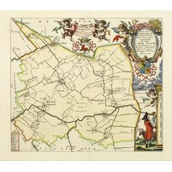
Over deese grietenije.. Eerste van Wester Goo..
Very decorative map centered on Menaam, Marsum and Boxum from the Uitbeelding der Heerlijkheit Friesland prepared by Schotanus. With ornamental title cartouche lower righ...
Place & Date: Leeuwarden, F.Halma, 1718
Henna ardera deel. De vijfde Grietenije van de Wester goo. . .
Very detailed map of "Henna ardera deel. De vijfde Grietenije van de Wester goo" in Friesland prepared by Bernardus Schotanus Steringa. With decorative title ca...
Place & Date: Leeuwarden, 1718
Kollumer land En het Nieuw Kruys land de vijfde gritenije van Oostergoo . . .
Very detailed map of "Kollumer land En het Nieuw Kruys land de vijfde gritenije van Oostergoo" in Friesland prepared by Bernardus Schotanus Steringa. Centered o...
Place & Date: Leeuwarden, F. Halma, 1718
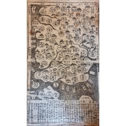
Paldobundo Province.
Woodblock printed map of Jeolla Province which was one of the historical Eight Provinces of Korea during the Kingdom of The map is drawn in "Paldo Bundo," styl...
Place & Date: 1710-1718
Donger deel.. derde grietenije van Ooster Goo. . .
This is a very decorative map of the area north of Dokkum from the Uitbeelding der Heerlijkheit Friesland prepared by Schotanus. With decorative title cartouche lower rig...
Place & Date: Leeuwarden, F.Halma, 1718

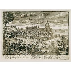
Terki, ville de la Circassie, dans l'Asie.
A very detailed panoramic view of Terki in the Caucasus, the capital of one of the most powerful Dagestani potentates of southeast Asia.Showing the Volga River. Foregrou...
Place & Date: Leiden, c. 1719
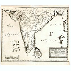
Carte du Golfe de Bengale, mer des Indes et rivieres du Gange . . .
Detailed scare map of the Southern part of India with Ceylon. Good detail along the coasts of Malabar, Coromandel, the Maldives islands and the Kingdoms of Visipour, Golc...
Place & Date: Leide, 1719
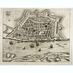
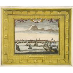
Riga.
Decorative view of Riga. This well executed engraving was published in 1729 and 1727 by Pieter van der AA, in Leiden in "Les Voyages tres-curieux et tres-renommez fa...
Place & Date: Leiden, 1719
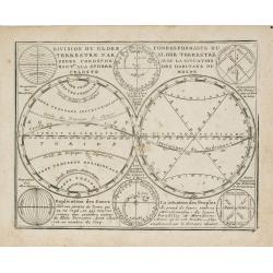
Division du Globe Terrestre par zones.. - Correspondance du Globe Terrestre avec la situation des habitants du monde.
A charming representation of various planetary models and systems according to the latest mathematical and scientific schemes of the day.From Le Nouveau et Curieux Atlas ...
Place & Date: Paris, 1719

Saba, ville en Perse.
Decorative view of Sabā / Dakān Sorkh) which is a village in Vahdatiyeh Rural District in present-day Iran.In the foreground are camels and horses. This well-executed e...
Place & Date: Leiden, 1719

Carte du Golfe de Bengale, Mer de Indes, et Riviere du Gange, Avec les Pais et Iles d'alentour, Savoir les Cotes de Malabar, Cormandel, Ile de Ceylon, Les Maldives . . .
Detailed map of the Southern part of India with Ceylon. Good detail along the coasts of Malabar, Coromandel, the Maldives islands and the Kingdoms of Visipour, Golconda, ...
Place & Date: Leiden, 1719
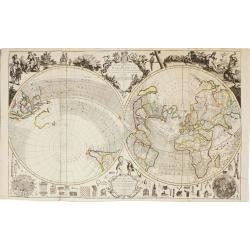
Le Nouveau et Curieux Atlas Geographique et historique, ou Le Divertissement des Empereurs, Roys, et Princes. Tant dans la Guerre que dans la Paix. Dédié A Son A.R. Monseigneur le Duc d'Orléans Regent du Roîaume de France.
Charming world atlas with double hemisphere world and the North American map feature the Island of California. In Asia and the Pacific, Australia is incompletely mapped a...
Place & Date: Paris, 1719
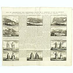
Vue et description des principales villes de l'Armenie et de la Georgie avec les habillements des femmes du pays, et ceux des prêtres et religieux armeniens. . .Tom: V N° 11 Pag: 28
View and description of the principal Armenian and Georgian cities with illustrations of Armenian women's garments as well as priests' and monks' clothing. The views are ...
Place & Date: Amsterdam, ca 1720
Het Groote Tafereel der Dwaasheid, vertoonende de opkomst, voortgang en ondergang der Actie, Bubbel en Windnegotie, in Vrankryk, Engeland, en de Nederlanden, gespleegt in den Jaare MDCCXX...
AN EARLY ISSUE of this biting and vulgar satire on the Mississippi and South Sea Bubbles and an extraordinary visual record with 78 plates of the first banking crash, sho...
Place & Date: Amsterdam, 1720
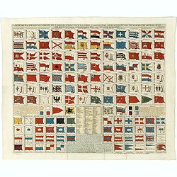
Carte des pavillons accompagnée d'observations pour en faire comprendre le blazon et les différentes devises aussy bien que d'une table alphabétique pour les trouver facilement.?
Map of 88 marine flags, including Malta, Turkey, Middelburg, Amsterdam, Portugal, Monaco, Tuscany, China, Nanking, the French Royal flag, French admiralty flag and mercha...
Place & Date: Amsterdam, 1720

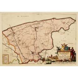
Arabiae Felicis, petrae et desertae.
A very striking map with a finely decorated title cartouche, published by Valk & Schenk, utilizing Jansson's original plate. Interestingly, this map uses the names th...
Place & Date: Amsterdam, 1720
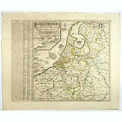
Nouvelle Carte des dix-sept Provinces des Pays-Bas.
Map of the 17 provinces of the Netherlands. In an inset upper left corner 17 coats of arms of each province and vignettes. The Channel is filled with Naval battles fought...
Place & Date: Amsterdam, ca. 1720
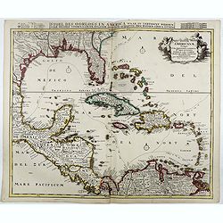
Stoel des Oorlogs in America Waar in Vertoont Werden Alle Desself Voornaamste Eylande . . .
Large impressive map of the West Indies with the Gulf of Mexico and Florida. The map shows prominently in the center Cuba, Haiti, the Bahamas and Florida, which is here m...
Place & Date: Amsterdam, c. 1720
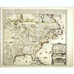
Carte de la Nouvelle France, ou se voit le cours des Grandes Rivieres de S. Laurens & de Mississipi..
Derived from de Fer's 1718 map, from west of the Mississippi it contains a mass of inland detail with notes and vignettes of the indigenous peoples and fauna of North Ame...
Place & Date: Amsterdam, 1720
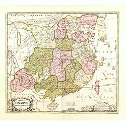
Imperii Sinarum nova descriptio.
Schenk and Valk's rare early 18th century issue of Janssonius milestone map of China, Korea and Japan after Martino Martini. Engraved by Johannes van Loon. The overall ba...
Place & Date: Amsterdam, ca. 1720
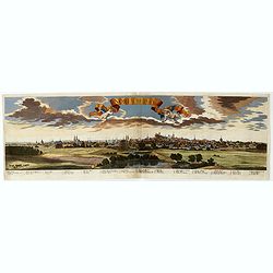
Norimberga.
A spectacular panoramic town-plan of Nuremberg, with legends numbered from 1-39 in German. With the title in a banderol.After a design by Friedrich Bernhard Werner (1690...
Place & Date: Augsburg, ca. 1720
Riga metropolis Livoniae.
A spectacular panoramic of Riga, with legends numbered from a-z and 1-16 in German. With the title in a banderol.After a design by Friedrich Bernhard Werner (1690-1776) ...
Place & Date: Augsburg, ca. 1720
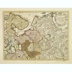
Carte nouvelle de Moscovie represente la partie Septentrionale dressée par G.De L'Isle. . .
Uncommon map covering the area north of Moscow, including Lapland. Prepared by G. de L'Isle.Joachim Ottens (1663 - 1719) and his sons Renier and Joshua were prominent Dut...
Place & Date: Amsterdam, 1720
Genehoa Jaloffi et Sierraliones regna.
Decorative and detailed map of the West African Coast, from Senegal to Sierra Leone. In the center the river Gambia to the mouth in the Atlantic. Upper left a dedication ...
Place & Date: Amsterdam, 1670 / 1720
Nostre Dame de Lorette.
A very RARE panoramic of Lorette and the church, including a numbered legend in both lower corners.The plate is numbered in black pencil in upper right corner.Published ...
Place & Date: Paris c.1720
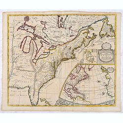
A new map of the English Empire in America. . .
This fine English map of eastern North America including Canada engraved by John Harris and first published by Robert Morden. John Senex acquired and made minor alteratio...
Place & Date: London, 1720
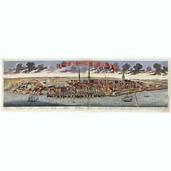
Amsterdam Capitale de la Hollande.
A panoramic of Amsterdam seen from 't IJ. Set within a decorative border, printed from a separate plate. Rare.
Place & Date: Leiden, 1720
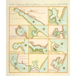
Carte des Principales Ports de Mer Bancs de sable &c: qui sont dans la Mer Rouge..
Some cities existed along the western coast of the Arabian peninsula, where they served as entrepots for transcontinental trade between Europe and Asia. Mecca, founded by...
Place & Date: Amsterdam, 1720
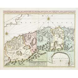
Nouvelle carte du Roiaume D'Alger divisée en toutes ses provinces, avec une partie due cotes D'Espagne . . .
Rare and detailed map of the coast of Algeria. Large inset map of the Bay of Alger (El-Jazir). Shows a coastline of Spain around Alicante. Two compass roses in the Medite...
Place & Date: Amsterdam, 1720
![Waare afbeelding van den vermaarden Heer Quinquenpoix. [True portrait of the renowed Mr. Quinquenpoix]](/uploads/cache/27965-250x250.jpg)
Waare afbeelding van den vermaarden Heer Quinquenpoix. [True portrait of the renowed Mr. Quinquenpoix]
Page taken from Het groote tafereel der dwaasheid : vertoonende de opkomst, voortgang en ondergang der actie, bubbel en windnegotie, in Vrankryk, Engeland, en de Nederlan...
Place & Date: Amsterdam, 1720
Huquang, Kiangsi, Chekiang ac Fokien.
A reissue of Janssonius' map of south east China, with wash color and uncolored cartouches.The map is based on the maps of Martin Martini, themselves based on Chinese sou...
Place & Date: Amsterdam, 1720
Bronwater of geneesmiddel voor de zieke actionisten.
Springwater or potion for the sick shareholder, taken from Het groote tafereel der dwaasheid : vertoonende de opkomst, voortgang en ondergang der actie, bubbel en windneg...
Place & Date: Amsterdam, 1720
Harlekin en Bombario en den rouw.
Harlequin and Bombario in mourning, taken from Het groote tafereel der dwaasheid : vertoonende de opkomst, voortgang en ondergang der actie, bubbel en windnegotie, in Vra...
Place & Date: Amsterdam, 1720
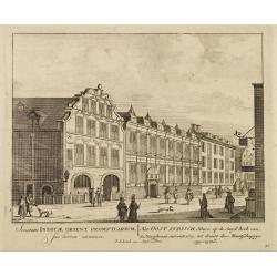
Het Oost Indisch Huys op de Suyd hock..
A decorative print of the East Indian House , the headquarters of the V.O.C., a place for meeting, trading and storage of spices and ship equipment.The maps and charts we...
Place & Date: Amsterdam, 1720
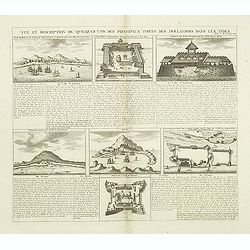
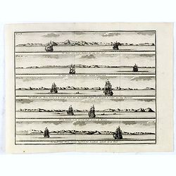
Vue et Description de Quelques-Uns des Principaux Forts des Hollandois dans les Indes .
Interesting sheet with seven detailed views illustrating the most important Dutch V.O.C. trading outposts and fortified colonial possessions in the East Indies, including...
Place & Date: Amsterdam, 1720
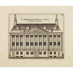
D' Admiralyteyts Huys - La maison de l'Amirauté.
Decorative print of the Admiralty House of the V.O.C., now-a-days Maritime Museum in Amsterdam.
Place & Date: Amsterdam, c.1720
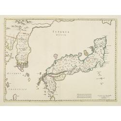
Japonia Regnum.
It is the first map to correctly show Korea as a peninsula. The rare Covens and Mortier issue of this important map of Japan and Korea, originally published by Blaeu. Thi...
Place & Date: Amsterdam, 1655 - 1720
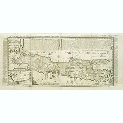
Carte de l'Ile de Java.
An inset plan of Batavia and clearly indicated rice fields, mountains, forests, towns in profile and even elephants suggest the wealth of detail found on this map. Modele...
Place & Date: Amsterdam, 1720
Beschrijving Gezicht van den Ykant af bezyden den Schreiers hoex Toren langs de Keulsche en Geldersche Kaei naer de Nieuwe Markt
This large engraving (560x920mm.) comes from a are series of 25 beautiful large views of Amsterdam and gives a colorful picture of the life and business of the city at th...
Place & Date: Amsterdam, ca. 1720
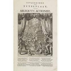
Uitlegginge der tytelplaat voor Arlequyn actionist.
Decorative print. Harlequin stockholder. The engraving (230x180mm.) depicts a kneeling conjuror with cups, balls and cards, Harlequin and Scaramouche drawing back curtain...
Place & Date: Amsterdam, 1720
Het Groote Tafereel der Dwaasheid.
AN EARLY ISSUE of this biting and vulgar satire on the Mississippi and South Sea Bubbles and an extraordinary visual record with 78 plates of the first banking crash, sho...
Place & Date: Amsterdam, 1720
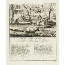
De kornet van vuil gewin of wortel en besse postiljon op zyn mager, doch niewlyks gemest varken uitschreewende de kompany is vol.
Page taken from "Het groote tafereel der dwaasheid : vertoonende de opkomst, voortgang en ondergang der actie, bubbel en windnegotie, in Vrankryk, Engeland, en de Ne...
Place & Date: Amsterdam, 1720
![Spiegel der Reden Voor de Wanhopende Actionisten. [Mirror for the reason of the despairing stockbrokers. ]](/uploads/cache/28094-250x250.jpg)
Spiegel der Reden Voor de Wanhopende Actionisten. [Mirror for the reason of the despairing stockbrokers. ]
Text page with copper engraving (150 x 100mm.) taken from Het groote tafereel der dwaasheid : vertoonende de opkomst, voortgang en ondergang der actie, bubbel en windnego...
Place & Date: Amsterdam, 1720
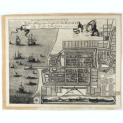
Waere Affbeeldinge Wegens het Casteel ende Stadt BATAVIA Gelegen opt Groot Eylant Java.
A good impression of this finely engraved and detailed plan of Batavia, present-day Jakarta, the Dutch center of trading activities in the East Indies. Copied after Cleme...
Place & Date: Amsterdam, 1721
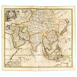
A New Map of Asia from the latest Observations Most Humbly Inscrib'd to the Right Honbl. George Earl of Warrington &c.
Fine map of Asia, with decorative title cartouche flanked by two figures in Asian dress, along with flora and fauna of the continent., based on the work of Guillaume De L...
Place & Date: London, 1721
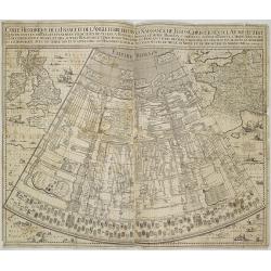
Carte historique de la France, et l'Angleterre depuis la naissance de Jésus-Christ jusqu'à l'an 1700, qui contient en abrégé les événements ...
A rare wall map showing a chronological tree of French and English historical events from the year of the birth of Christ until 1700. The map is prepared by Jérôme Andr...
Place & Date: Paris, c. 1721
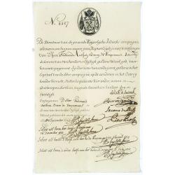
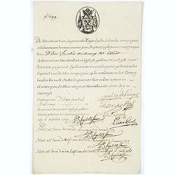
Very rare share in the Ostend Company. (4527)
Upper left hand corner share number 4527 in manuscript. In top emblem of the Ostend Company in copper engraving. Text: De Directeurs van de generale Keijserlijche- Indisc...
Place & Date: Antwerp / Ostend 1723
Very rare share in the Ostend Company. (299)
Upper left hand corner share number "299" in manuscript. In top emblem of the Company in copper engraving. Text: " De Directeurs van de generale Keijserlij...
Place & Date: Antwerp / Ostend, 1723
Plan de la ville de Malthe ses Forts, ses Nouvelles Fortiffications. . .
Detailed plan of Valletta. In upper right corner a key (A-Z & 1-32) to the principal places in town. Prepared by N.de Fer and re-issued by Danet.
Place & Date: Paris, 1723
![[12 volumes] Recueil des voyages qui ont servi à l'établissement et aux progrez de la Compagnie des Indes Orientales, forméedans les Provinces-Unies des Païs-Bas...](/uploads/cache/43700-250x250.jpg)
[12 volumes] Recueil des voyages qui ont servi à l'établissement et aux progrez de la Compagnie des Indes Orientales, forméedans les Provinces-Unies des Païs-Bas...
An important richly illustrated compendium of the first Dutch voyages to East India, of great interest for the history and establisment of the Dutch global trade, particu...
Place & Date: Rouen, Pierre Le Boucher, 1725
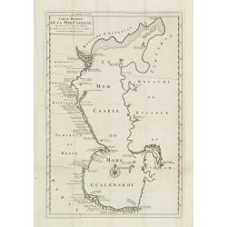
Carte Marine De La Mer Caspiene levée suivant les ordres de S.M.Cz. En 1719, 1720 et 1721.
Detailed of the Caspian Sea, prepared by Karl van Verden in 1722. Van Verden was a Russian sailor and the Czar's Special Commander, who produced the first accurate map of...
Place & Date: Paris, ca. 1725
Die Insel Formosa neu abgemessen auf Befehl Kaysers Kamhi.
One of the earliest obtainable printed maps of Taiwan or Formosa Island. It was issued around 1726 to illustrate Joseph Stöcklein's [Stoecklein] compellation of Jesuit m...
Place & Date: Augsburg, 1726
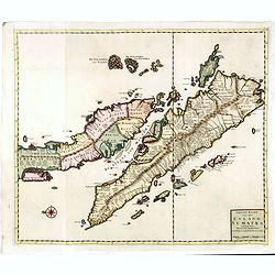
Nieuwe Kaart van het Eyland Sumatra..
Fine chart depicting the Island of Sumatra and the southern coasts of Malaysia from Quedo to Johore. North is orientated to the left of the page. Singapore is probably id...
Place & Date: Amsterdam, 1726

De Landvoogdy der Moluccos met de Aangrenzende Eylanden . . .
Two charts on one sheet depicting the Moluccas islands. Little interior detail is given but the coastlines, settlements and principal coastal features are identified. To ...
Place & Date: Amsterdam, 1726
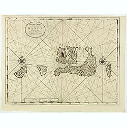
Nieuwe Caart der Eylanden van Banda.
Decorative map of the Banda Islands.François Valentijn (1666-1727), a missionary, worked at Amboina from 1684 to 1694 and 1705 to 1713 and travelled extensively in the V...
Place & Date: Amsterdam, 1726
![Beschrijving van Oud en Nieuw Oost-Indien. Vervattende een Naukeurige en uitvoerige verhandelinge van Nederlands Mogentheyd [...] met meer dan thien honderd en vyftig Prentverbeeldingen verrykt...](/uploads/cache/47258-250x250.jpg)
Beschrijving van Oud en Nieuw Oost-Indien. Vervattende een Naukeurige en uitvoerige verhandelinge van Nederlands Mogentheyd [...] met meer dan thien honderd en vyftig Prentverbeeldingen verrykt...
"The most comprehensive work on Asia published in Europe during the early colonial period" (Landwehr). The first book to give a comprehensive account in text an...
Place & Date: Dordrecht /Amsterdam, 1724-1726
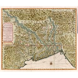
Nieuwe kaart van 't Koninckryk Bengale. . .
Rare map Bangladesh with the Ganges delta, including Calcutta. Giving great detail with trade routes, European trade settlements, etc. Prepared by Joh. Van Leenen who was...
Place & Date: Amsterdam, 1726
De Kust van Nova Guinea tot aan deze bogt . . .
De kust van Nova Guinea tot aan deze bogt.De Kust van Nova Guinea ofte Salomon Sweers hoek. Het Landt van Nova Guinea in de Groote Bocht daar wy vergeefs hoopten een doo...
Place & Date: Amsterdam, 1726
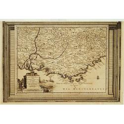
Carte du Gouvernement de Provence, suivant les nouvelles observations...
Fine copper engraved and decorative map of the Provence region in the south of France. It includes the cities of Nimes, Viviers, Avignon, Aix and Nice. The pictorial cart...
Place & Date: Amsterdam 1728
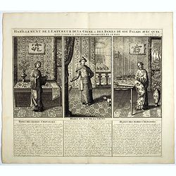
Habillement de l'Empereur de la Chine & des Dames de son Palais..
This impressive engraving is a wonderful example of Chatelain’s elegant plates.Divided in 3 panels, showing examples of costumes of Chinese ladies and those of the king...
Place & Date: Amsterdam, ca. 1728
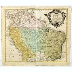
Tabula Americae Specialis Geographica Regni Peru, Brasiliae, Terra Firmae & Reg: Amazonum, Secundum relationes de Herrera, de Laet & PP d Acuña & M. Rodriguez . . .
A good and clean copy of Homann's map of the northern part of South America. The map is on the Valley of the Amazon and delineates the Amazon and its labyrinth of tributa...
Place & Date: Nuremberg, 1728
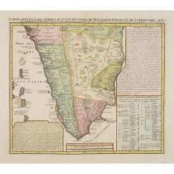
Carte nouvelle des Terres de Cucan..
Prepared by H.Reland (1676-1718) a professor active in Utrecht and specialized in Asian languages, geography and religions. His first map was a map of Japan copied after ...
Place & Date: The Hague, 1728
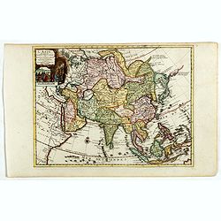
L'Asie suivant les nouvelles observations...
Uncommon edition of this map of Asia. From Le Nouveau Theatre du Monde, ou la Geographie Royale.The map is of interest for the use of Mer Orientale, the sea between Kor...
Place & Date: Amsterdam, 1728
![[Printed on silk] Nieuw Wassende Graaden Paskaart Vertoonende alle de bekende Zeekusten en Landen op den geheelen Aard Boodem of Werelt door Gerard van Keulen. . .](/uploads/cache/31640-250x250.jpg)
[Printed on silk] Nieuw Wassende Graaden Paskaart Vertoonende alle de bekende Zeekusten en Landen op den geheelen Aard Boodem of Werelt door Gerard van Keulen. . .
A very scarce and beautiful chart on Mercator's projection printed on silk. With the name of Gerard van Keulen and the privilege. The map shows great interior detail, inc...
Place & Date: Amsterdam, 1728
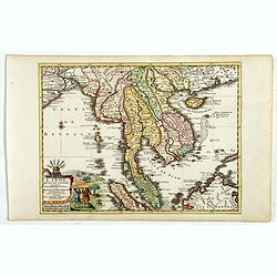
L'Inde de la le Gange, suivant les nouvelles observations...
Uncommon edition of this map of Malaysia, Thailand, Indo China and the Northern parts of the islands of Sumatra and Borneo. Singapore marked as Sincapour. With decorative...
Place & Date: Amsterdam, 1728
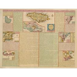
Carte qui contient..Iles & Terres..L'Amerique..Jamaique..
Eight maps on one sheet. From Chatelain's Atlas Historique et Méthodique . Including maps of Bermuda, Jamaica, New England with Long Island, Carolina, Chesapeake and Del...
Place & Date: Amsterdam 1728
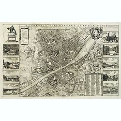
Florentia Pulcherrima et Ruriae Civitas.
Detailed bird's-eye view of the town of Florence in Tuscany region, first published in Frederick de Wit's rare town book. With two keys 1-17 and 1-228 to important spots ...
Place & Date: Amsterdam, Leiden, 1697 / 1729