Browse Listings
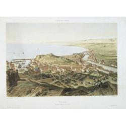
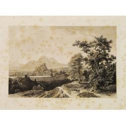
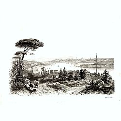
Nice Vue prise audessus de Montalban.
Beautiful view of Nice from the book "l'Italie à vol d'oiseau".
Place & Date: Paris, 1850
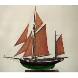
MAUREEN Shipping model of a fishing boat.
This type of fishing ships were used by the Dutch fisherman to fish for codfish, and even reached with them into the Canadian waters.Overall dimensions: 1400 x 100 x 230m...
Place & Date: Netherlands, ca. 1850

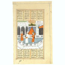
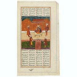
Persian miniature paintings, Mogul Dynasty.
Indo/Persian, Mogul Dynasty miniature painting in delicate Opaque watercolors on paper, with Islamic scripts on recto and verso. Miniature about 135 x 150mm. Painted in g...
Place & Date: Northern Indian Mogul dynasty, ca 1800-1850
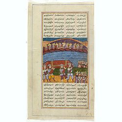
Persian miniature paintings, Mogul Dynasty.
Indo/Persian, Mogul Dynasty miniature painting in delicate Opaque watercolors on paper, with Islamic scripts on recto and verso. Miniature about 70 x 150mm. Painted in gi...
Place & Date: Northern Indian Mogul dynasty, ca 1800-1850

View of Singapore
Very rare view of Singapore from the Singapore River Basin. With a numbered key (1-19) underneath the illustration. In the center Government Hill with Governer's House (1...
Place & Date: ca. 1850
![Posesiones de America : Isla de Cuba. [together with] Isla de Cuba. . .](/uploads/cache/23458-250x250.jpg)
Posesiones de America : Isla de Cuba. [together with] Isla de Cuba. . .
Wall size sea chart and map of land areas showing all of Cuba, part of Florida Keys plus San Adios and Salvador Grande in the Bahamas.Minute topographical, political, and...
Place & Date: Madrid, 1853 / 1851
Plan de Constantinople, non compris ses faubourgs. Grave d'apres les documents du ministere de la Guerre par E. Olivier.
A very rare lithographic town-plan of Istanbul, Scale 98 yards to one inch., printed in Pera, Istanbul by E. Olivier. The ornate design on the top of the title is a tugh...
Place & Date: Péra, Istanbul, 1851
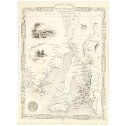
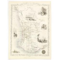
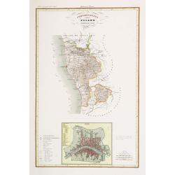
Part of South Australia.
Decorative steel engraved map of part of South Australia, surrounded by illustrations of Adelaide, natives on a catamaran, an Australian dog and a nymphicus bird illustra...
Place & Date: London, ca. 1851
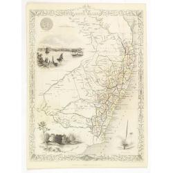
New South Wales.
Decorative steel engraved map of New South Wales, surrounded by illustrations of Sydney Cove, native trees and the seal of New South Wales. Interlocking border design. Ta...
Place & Date: London, ca. 1851
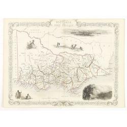
Victoria or Port Phillip.
Decorative steel engraved map of Victoria or Port Phillip, surrounded by illustrations of Melbourne, indigenous people and the Glenelg River. Interlocking border design. ...
Place & Date: London, ca. 1851
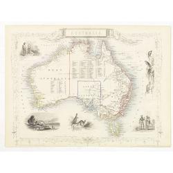
Australia.
Decorative steel engraved map of Australia, surrounded by illustrations of Sydney harbor, birds, kangaroos and local people. Interlocking border design. Taken from "...
Place & Date: London, ca. 1851
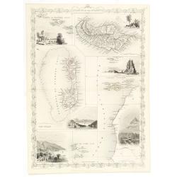
Western Australia. Swan River.
Decorative steel engraved map of part of Western Australia and Swan River, surrounded by illustrations of Perth, Aborigines and sheep shearing. With the seal of Western A...
Place & Date: London, ca. 1851
Islands in the Atlantic.
Decorative steel engraved map of Islands showing the Azores, Madeira, Bermuda, the Canaries and the Cape Verdes. Interlocking border design. Taken from "The illustra...
Place & Date: London, ca. 1851

Cape Colony.
A decorative steel engraved map from the famous Victorian publisher John Tallis and Company, published ca.1851. Drawn and engraved by J Rapkin, while the four corner vign...
Place & Date: London, Edinburgh, Dublin, 1851

Simori.
Portrait of Simori.Von Siebold was born in Wurtzburg, in Germany, and worked for the Dutch government as a doctor in Java. In Japan, where Von Siebold arrived in 1823 at ...
Place & Date: Leiden, 1832-1852
![Dépt. De L'Aude. N°10. [ Carcassonne ]](/uploads/cache/27089-250x250.jpg)
Dépt. De L'Aude. N°10. [ Carcassonne ]
Map of the Aude region, centered on the town of Carcassonne. Reaching to the right till the Mediterranean.Lovely map from one of the last decorative atlases of the ninete...
Place & Date: Paris, A. Combette, 1852
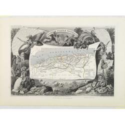
Algérie, Colonie Française. N°87.
Map of Algeria.Lovely map from one of the last decorative atlases of the nineteenth century.The rather simple map is framed by medallion portraits and coats of arms, and ...
Place & Date: Paris, A. Combette, 1852
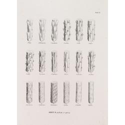
ABIETUM phyllulae et pulvini.s. Tab. 137.
From his famous work 'Flora Japonica'. Von Siebold was born in Wurtzburg, in Germany, and worked for the Dutch government as a doctor in Java. In Japan, where Von Siebold...
Place & Date: Leiden, 1852
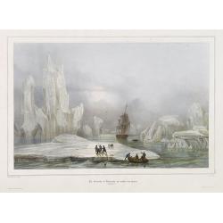
La Corvette la recherche au milieu des glaces.
Beautiful lithograph by A. Mayer and Bayot of the corvette "La recherche" surrounded by Ice. Published by Arthus-Bertrand and Lemercier in Paris.From Joseph Pau...
Place & Date: Paris. Arthus-Bertrand, 1838-1852
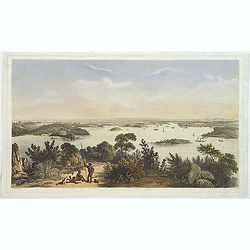
(The City And Harbour Of Sydney From Near Vaucluse.)
One of the most sought after views of the city and harbour of Sydney seen from Near Vaucluse, 1852. Magnificent hand-colored tinted lithograph and finished by gum-Arabic....
Place & Date: London, J. Hogarth, 1852
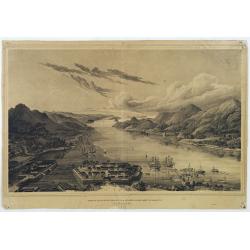
Gezigt op de haven en de baai van Nagasaki.
A very rare birds-eye view showing Deshima and Nagasaki bay. Von Siebold was born in Würtzburg, in Germany, and worked for the Dutch government as a doctor in Java. In J...
Place & Date: Leiden 1832-1852
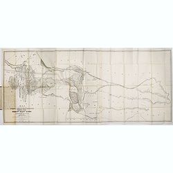
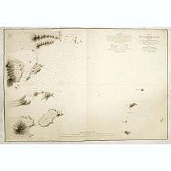
Map of the Great Salt Lake And Adjacent Country in the Territory Of Utah. Surveyed in 1849 and 1850, under the orders of Col. J.J. Abert ...
Map of the Great Salt Lake And Adjacent Country in the Territory Of Utah. Surveyed in 1849 and 1850, under the orders of Col. J.J. Abert .. by Capt. Howard Stansbury .. a...
Place & Date: Ackerman, New York, 1852
![[Collection of six maps of Australia and New Zealand.]](/uploads/cache/48412-250x250.jpg)
[Collection of six maps of Australia and New Zealand.]
Collection of maps including 6 engraved maps by 19th century German, French and English cartographers depicting Australia and New Zealand.This made to order atlas contain...
Place & Date: Germany, 1832-1852
![ISLA DE CUBA [with 2 maps] Plano Pintoresco De La Habana con los numeros de las casas B. May y Ca. 1853. (with) Inset map Puerto y Cereanias De La Habana. (with) 14 views of Havana & prominent buildings.](/uploads/cache/36720-250x250.jpg)
ISLA DE CUBA [with 2 maps] Plano Pintoresco De La Habana con los numeros de las casas B. May y Ca. 1853. (with) Inset map Puerto y Cereanias De La Habana. (with) 14 views of Havana & prominent buildings.
Lithographic town-plan surrounded with views of the city of Havana including the "Fuente De La India En El Paseo De Isabel 2a." and "Vista Gral De La Haban...
Place & Date: Havana, 1853
![Le Sacre Hagard [Haggard-falcon]](/uploads/cache/44315-250x250.jpg)
Le Sacre Hagard [Haggard-falcon]
A beautiful elephant folio sized colored lithograph of a Hagard Falcon, taken from the famous book on Falconry Traite de Fauconnerie by Schlegel and A.H. Verster van Wulv...
Place & Date: Leiden, 1844-1853
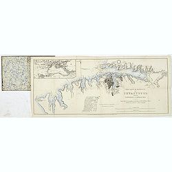
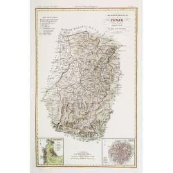
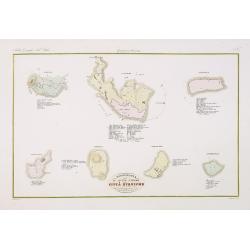
The town & harbour of Sevastopol with the batteries & approaches. . .
Rare colored linen backed map showing the harbour and town of Sevastopol, with soundings. In upper left corner a inset map (65x150mm) of the Black Sea. In bottom part a l...
Place & Date: London, March 27th, 1854
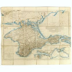
The Crimea, chiefly from surveys made by order of the Russian government. . .
Map of Crimea and the Sea of Azov. In lower right corner two inset maps showing Sebastopol inlet and harbour and a second one with the Black Sea. This second maps shows t...
Place & Date: London, 1854
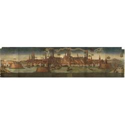
(Lübeck) Lvbeca vrbs. imperialis libera. civitatvm. Wandalicarvm. . . .
Impressive more than 3 meters wide panoramic town view after a woodblock engraving from Elias Diebel, initially made in 1552. Of this original woodblock, Bachmann mention...
Place & Date: Germany, c. 1855
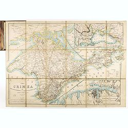
The Crimea by James Wyld Geographer to the Queen & H.R.H. Prince Albert.
Fourth edition of this folding map of the Crimea. In upper right corner an inset map of the areas around the Black Sea; "The Town & Harbor of Sevastopol with the...
Place & Date: London, 1855
Military map of the countries between Odessa & Perekop with the stations of the Russian forces.
Rare colored linen-backed map showing Russian troop positions and Odessa Batteries. On the inside of the cover a list of "Wyld's list of recent publications : seat o...
Place & Date: London, ca. 1855
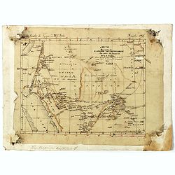
Carte d'unne partie de l'Arabie Septentrionale Pour suivre les Voyages de Mr. G.A. Vallin. . .
This is the original hand-drawn map by Victor Adolphe Malte-Brun of "Carte d'unne partie de l'Arabie Septentrionale Pour suivre les Voyages de Mr. G.A. Wallin",...
Place & Date: Paris, November 1855
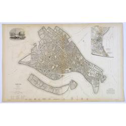
Venice.
A lovely steel engraved plan, on 2 sheets, of Venice by the Society for the Diffusion of Useful Knowledge (SDUK). This English philanthropic enterprise was entirely devot...
Place & Date: London, 1855
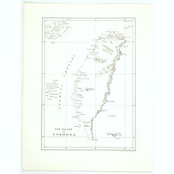
The island of Formosa.
A small, but historically important map of Taiwan (the first American lithograph of Taiwan) made by the American Commodore Matthew C. Perry and published by Ackerman. The...
Place & Date: New York, 1856

Provincie Noord-Braband. / Breda, de Langstraat. . .
Decorative and uncommon custume plate lithographed by R. de Vries and published by Frans Buffa & Zonen in Amsterdam. A group of 4 women from the area of Baronie van B...
Place & Date: Amsterdam, 1857

Provincie Noord-Braband.
Decorative and uncommon costume plate lithographed by Desguerrois & Co. and published by Frans Buffa & Zonen in Amsterdam. 12 illustrations of Brabant costumes: 1...
Place & Date: Amsterdam, 1857

Borneo (together with) The Philippine Islands.
Two maps on one sheet. Both maps are highly detailed, filled with place names. The Philippines are shown from the Bashee Islands in the north to the Sooloo Archipelago in...
Place & Date: London, ca. 1858

Planisfero (Tav III)
A large-format world map with a key to the steamship routes, telegraph lines and land routes in Europe. Finely engraved and beautifully colored and was prepared by Girola...
Place & Date: Rome, 1858
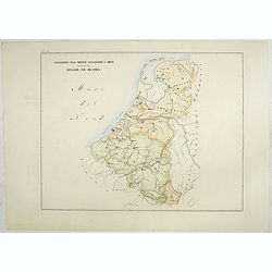
Circoscrizione delle Provincie ecclesiastiche e Diocesi nei regni del Belgio, ed Olanda (Tav LXI)
This large-format map showing Belgium and Holland with its different dioceses. The map is finely engraved and beautifully colored and was prepared by Girolamo Petri, a la...
Place & Date: Rome, 1858
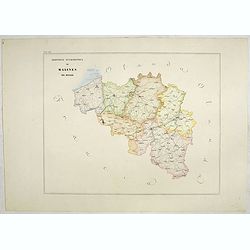
Provincia ecclesiastica di Malines nel Belgio (Tav LXII)
This large-format map of Belgium with its different dioceses. The map is finely engraved and beautifully colored and was prepared by Girolamo Petri, a lawyer who served a...
Place & Date: Rome, 1858

Sick and wounded embarking at Hong-Kong on Board the Steamer.
Large view of the harbour with numerous ships and people. From the Illustrated London News, October 23, 1858.
Place & Date: London, October 1858
Provincie ecclesiastiche di Leopoli e Fogaras ed Altre Diocesi di Rito Greco (Tav LXXV)
This large-format Romania map is finely engraved and beautifully colored and was prepared by Girolamo Petri, a lawyer who served as a senior official within the Vatican�...
Place & Date: Rome, 1858
Selling price: $250
Sold in 2025
Volume III of the monumental atlas, ‘L’Orbe Cattolico ossia Atlante Geografico Storico Ecclesiastico’.
PETRI Girolamo's extremely rare Atlas volume III of the monumental atlas, ‘L’Orbe Cattolico ossia Atlante Geografico Storico Ecclesiastico’, respectively depictin...
Place & Date: Rome, 1858
Salzbourg.
Uncommon and decorative lithography published by Carl Johan Billmark and printed by Lemercier in Paris, 55 rue de Seine, the leading firm in Europe at that time. From: It...
Place & Date: Paris, c.1859
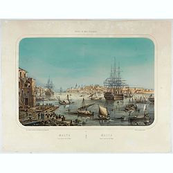
Malte Vue prise de la Mer. - Malta Vista lomada del mar.
Very decorative view of the Grand Harbour of Malta by Louis Lebreton, published in "Ports de Mer d’Europe" in 1859 by L. Turgis in Paris.This lithography show...
Place & Date: Paris, Turgis, 1859
Governo di Venezia / Provincie di Padova e di Rovigo.
Very finely engraved and detailed map of the government of Venice. Lower left corner, two inset plans of Padova and Rovigo. Upper right corner, a key. Engraved by Vettori...
Place & Date: Rome, 1860
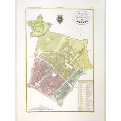
Pianta della citta di Modena.
Very finely engraved and detailed plan of Modena. Coat of arms of the town centred on the upper part. Engraved by V.Angeli and included in: Atlante Geografico dell Italia...
Place & Date: Rome, 1860
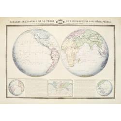
Tableau Sphéroïdal de la Terre ou Mappemonde en deux Hémispères. . .
Large steel engraving presenting the whole World in different projections, namely showing the convexity of the Earth.At the bottom a temperature contour map of the world ...
Place & Date: Paris, 1860
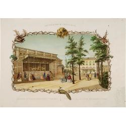
Rotterdamse Diergaarde. . .
Decorative view of Zoo of Rotterdam. To the right the house of the manager of the zoo. Decorated with personages in typical dress watching lions.
Place & Date: Amsterdam, 1860
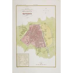
Pianta della citta di Ravenna.
Very finely engraved and detailed plan of Ravenna. Engraved by V.Angeli and included in: Atlante Geografico dell Italia. To the lower left a key to the principal building...
Place & Date: Rome, 1860
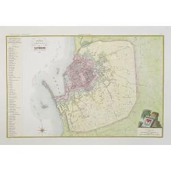
Pianta della citta di Livorno.
Very finely engraved and detailed plan of Livorno. Engraved by V.Angeli and included in: Atlante Geografico dell Italia . To the left, a key to the principal buildings a...
Place & Date: Rome, 1860

IV Compartimento Aretoni. . .
Very finely engraved and detailed map centered on Arezzo and Lago Trasimeno. Lower part three inset plans of Cortona, Arezzo and Chiusi. In upper corners plans of Montepu...
Place & Date: Rome, 1860

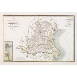
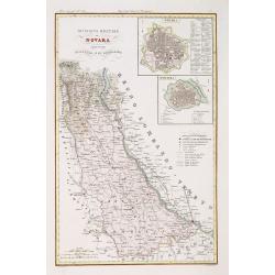
Divisione militaire di Novara. Provincie di Valsesia e di Vercelli.
Very finely engraved and detailed map centered on Vercelli and Varalio. Lower part two inset plans of Vercelli and Varallo and sacro Monte. Engraved by Pietro Manzoni and...
Place & Date: Rome, 1860

Governo di Venezia / Provincia di Udine.
Very finely engraved and detailed map of the area of Udine, with Trieste in lower right corner. Lower left corner an inset plan of Trieste : upper right corner, an inset ...
Place & Date: Rome, 1860

Compartimento Fiorentino. (Florence)
Very finely engraved and detailed map of the province of Firenze (Florence) Upper and lower part of the map, three inset plans of Namminiato, Modigliani and Volterra, Pis...
Place & Date: Rome, 1860
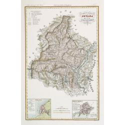
Divisione Militare di Novara. Novara / Lomellina.
Very finely engraved and detailed map of the province of Novara. Upper right corners, two inset plans of Novara and Mortara. Key on the lower right side. Engraved by Vett...
Place & Date: Rome, 1860
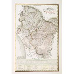
Ducato di Lucca.
Very finely engraved and detailed map of the region around Lucca. Lower part of the map, two inset lists of the mountains height and the local minerals. Engraved by Vetto...
Place & Date: Rome, 1860
Divisione Militare di Novara. Pallanza / Ossola.
Very finely engraved and detailed map of the region of Novara, including Lago Maggiore to the right. Lower corners, two inset plans of Pallanza and Ossola. Upper right co...
Place & Date: Rome, 1860
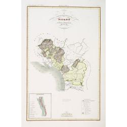
Compartimento Pisano.
Very finely engraved and detailed map of the territory of Pisa, including the region of Lucca and Estense. Lower left corner, an inset plan of Pontremoli. In the lower ri...
Place & Date: Rome, 1860
Compartimento Pisano.
Very finely engraved and detailed map centered on Pisa, including Livorno. Centered on the lower part, an inset plan of Pisa. Lower left corner, a key. Engraved by Vetto...
Place & Date: Rome, 1860
Divisione Militare di Cuneo. Mondovi / Alba.
Very finely engraved and detailed map of Cuneo, centered on the towns of Mondovi and Alba. Lower corners, two inset plans of Mondovi and Alba. Upper right corner, a key. ...
Place & Date: Rome, 1860

Souvenirs des Pyrénées. Vues prises aux environs des eaux thermales de Bagnères-de-Bigorre, Bagnères-de-Luchon, Cauteretz, Saint-Sauveur, Barèges, Les-eaux-Bonnes, Les-Eaux-Chaudes & Pau.
The thermal baths Bagnères de Bigorre, Bagnères de Luchon, Cauteretz, Saint-Sauveur, Barèges, Les Eaux-Bonnes and Pau in the Pyrenees. Beautiful collection of 24 litho...
Place & Date: Pau, A.Basset, ca. 1860
Topografia di Alcune Antiche Citta Etrusche.
Very finely engraved and detailed map of several Etruscan cities. Engraved by Vettorio Angeliand included in: Atlante Geografico dell Italia .
Place & Date: Rome, 1860
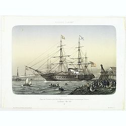
AFFAIRES D'ORIENT Départ des Grenadiers de la Garde Anglaise, à bord du Steamer transatlantique l'Orenoco. . .
Beautiful lithography of the British steamboat "l'Orenoco" departure from Southampton in May 1854, with soldiers leaving for the Crimean War. After a design Lou...
Place & Date: Paris, Lemercier, c.1860
![[Title page] Album delle principali vedute di Venezia disegnate da Marco Moro. . .](/uploads/cache/32269-250x250.jpg)
[Title page] Album delle principali vedute di Venezia disegnate da Marco Moro. . .
The title page has a virgin and the lion of Saint Mark sitting on an island with the background of the town of Venice. Learn more about map printing and views of Venice ...
Place & Date: Venice, G. Brizeghel, ca 1860
(Untitled view from Scutari with a view of Constantinople)
Panoramic view from Scutari with a view of Constantinople in the distance, after a design by Johann Schranz. Published by J. Missiriè.
Place & Date: Paris, 1860
Manuscript page from a Shahnameh, The Book of Kings, written by Ferdowsi.
Page with large miniature 187 x 160mm. from the Shahnameh, or ("The Book of Kings"), which is a long epic poem written by the Persian poet Ferdowsi between c. 9...
Place & Date: Kashmir, ca. 1830-1860
Manuscript page from a Shahnameh, The Book of Kings, written by Ferdowsi.
Page with large miniature 160 x 160mm. from the Shahnameh, or ("The Book of Kings"), which is a long epic poem written by the Persian poet Ferdowsi between c. 9...
Place & Date: Kashmir, ca. 1830-1860
![[Europe depicted as a Queen]](/uploads/cache/41499-250x250.jpg)
[Europe depicted as a Queen]
Among the most striking of early cartographic curiosities is Europe regina or Queen of the world first published by Johannes Bucius' and populized by Sebastian Münster.....
Place & Date: France, ca. 1860
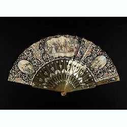
A fan combining views of Hong Kong (right), Canton (center), and Macau.
The fan shows nice images of Macau, Hong Kong and Canton on onside and on verso a garden with 45 characters welcoming a rider on his white horse. Their clothes are height...
Place & Date: China, ca. 1850-1860
Country pleasures.
Folding fan made of a double sheet of lithographed paper, enhanced with gouache and watercolor, with a decoration of three cartouches with gallant scenes of French countr...
Place & Date: France, ca. 1850-1860
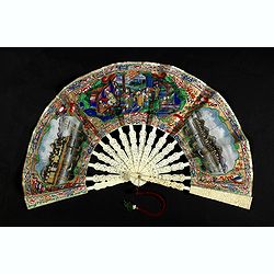
A fan combines views of Hong Kong (right), Canton (left), China, ca 1850-1860.
The fan shows nice images of Hong Kong and Canton on onside and on verso a garden with 39 characters welcoming a rider on his white horse. Their clothes are heightened in...
Place & Date: China, ca. 1850-1860
Plan de la rade de Macao (chine) Levé d'après les ordres mr. Rocquemaurel.
Very detailed chart of Macao and several of the surrounding Islands, and features numerous depth soundings throughout. Prepared by captain, Gaston de Rocquemaurel. Logo o...
Place & Date: Paris, c.1856 / 1863
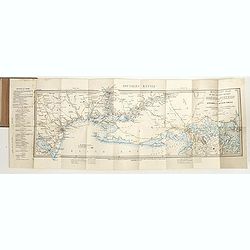
![[Lot of 9 maps] Plan général de Sébastopol avec indication des travaux du siege et de la defense au 28 mars - 9 avril 1855. Feuille 10. xiii](/uploads/cache/33907-250x250.jpg)
[Lot of 9 maps] Plan général de Sébastopol avec indication des travaux du siege et de la defense au 28 mars - 9 avril 1855. Feuille 10. xiii
A group of nine (of 14) very rare panoramic town-plans of the siege of Sebastopol or maps of the Crimea. In lower margin : "Gravé au Dépôt topographique de la Gue...
Place & Date: St. Petersburg, N. Thieblin, 1863
![[Macaire] Abus de l'article 214 du code civil. Madame mon épouse... (Plate 50)](/uploads/cache/17389-250x250.jpg)
[Macaire] Abus de l'article 214 du code civil. Madame mon épouse... (Plate 50)
Macaire personified the clever business man, who was willing at any time to throw moral and ethical principles overboard for a quick buck. His personality fitted exactly ...
Place & Date: Paris, 1864
![[Macaire] Pensionnat Robert-Macaire. Mr le professeur. . . (Plate 4)](/uploads/cache/17390-250x250.jpg)
[Macaire] Pensionnat Robert-Macaire. Mr le professeur. . . (Plate 4)
Macaire personified the clever businessman, who was willing at any time to throw moral and ethical principles overboard for a quick buck. His personality fitted exactly t...
Place & Date: Paris, 1864
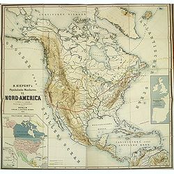
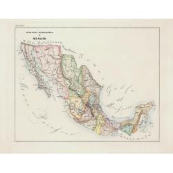
Kiepert's Physikalische Wandkarten. VI. Nord-America.
Large folding school wall map of North and Central America printed in chromo-lithography. Published by Dieter Reimer and printed by Leopold Kraatz in Berlin. Three inset...
Place & Date: Berlin, Dieter Reimer, 1864
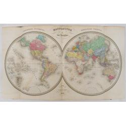
Atlas usuel de Géographie Moderne…
Complete with title page, contents page, and all 32 double-page maps of European and regional maps of the world, including Oceania, the Americas, Asia, Africa, etc. All i...
Place & Date: Paris, c. 1865
Selling price: $1200
Sold in 2024
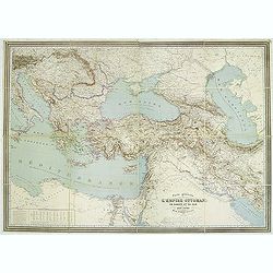
Carte générale de L'Empire Ottoman en Europe et en Asie dressée par Henri Kiepert . . .
Large School wall map of Turkish Empire printed in chromo-lithography. Published by Dieter Reimer and printed by Ferdind Barth in Berlin. This rare map has two insets in ...
Place & Date: Berlin, Verlag von Dietrich Reimer, 1867
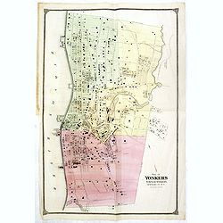
Plan of Yonkers Town of Yonkers Westchester Co. N.Y. . . .
Fine lithographed map of Yonkers, New York. The map provides the names of specific homeowners, as well as information about the occupations and physical locations of the ...
Place & Date: New York, 1867
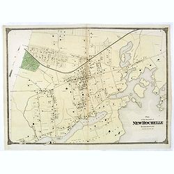
Plan of the Borough of New Rochelle, Westchester Co. N.Y.
Fine lithographed map of the plan of the Borough of New Rochelle. The map provides the names of specific homeowners, as well as information about the occupations and phys...
Place & Date: New York, 1867