Browse Listings

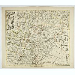
A new & accurate map of Louisiana, with part of Florida. . .
An English view of North America compiled from available French maps, especially those of Bellin used in Charlevoix's History of New France. English cartographers had lit...
Place & Date: London, 1744
Allerneuester geographisch- und topographischer Schau-Platz von Africa und Ost-Indien. . .
An early issue of this important book by Johann Wolfgang Heydt's describing the Dutch factories, settlements and stations at the hands of the Dutch East India Company in ...
Place & Date: Wilhermsdorf, Tetscher u. Nürnberg, Homanns Erben, 1744
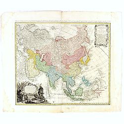
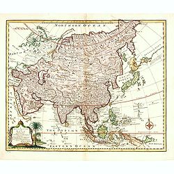
Asia secundum legitimas projectionis stereographicae.
Highlighted area covers part of Spain, eastern coast of Ireland to western part of Papua New Guinea and the Asian continent from the Northern Polar Sea to the Indian Ocea...
Place & Date: Nurenberg, 1744
![[Title page] Atlas Minor Praecipua Orbis Terrarum Imperia, Regna et Provincias , Germaniae Potissimum. . .](/uploads/cache/48479-250x250.jpg)
[Title page] Atlas Minor Praecipua Orbis Terrarum Imperia, Regna et Provincias , Germaniae Potissimum. . .
An attractive and highly decorative title page to Seutter's Atlas Minor. Engraved by Martin Crophius after Jacob Weyerman. The engraving is packed with lively figures fro...
Place & Date: Augsburg, 1744
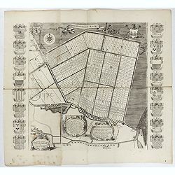
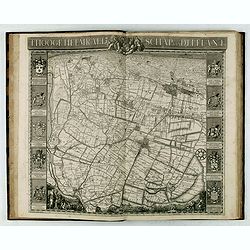
Chaerte vande Wieringer waert, de welcke inden jaere XVI… (Wieringerwaard)
Rare wall map of the Wieringerwaard polder, as raffled on 12 July 1611. The polder was laid dry in 1610. It border, and also the border of the municipality, were the Zuid...
Place & Date: 1741-1744
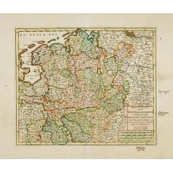
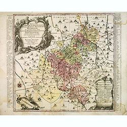
Nieuwe Kaart van de Westfaalse Kreits..
Isaac Tirion was born in Utrecht ca. 1705. He came to Amsterdam ca. 1725. Tirion published a number of important books, many of which are still in demand for their intere...
Place & Date: Amsterdam, 1745
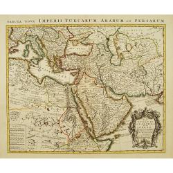
Carte de la Turquie, de l'Arabie et de la Perse..
Large map of the Near East, based upon earlier maps by De L'Isle. Shows also most part of the Mediterranean basin as well as north-eastern Africa. Relief shown pictoriall...
Place & Date: Amsterdam c. 1745
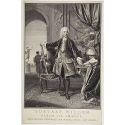
Gustaaf Willem Baron van Imhoff.
Decorative portrait of Gustaaf Willem Baron van Imhoff, who was Governor for the V.O.C. (Dutch East Indian Company) in Indonesia.
Place & Date: Amsterdam, 1745
![Carte de la coste orientale de la Chine depuis Amoy, jusqu'à Chusan avec une partie de l'Isle Formose [with] Plan du port d'Amoy ou Emouy.](/uploads/cache/33583-250x250.jpg)
Carte de la coste orientale de la Chine depuis Amoy, jusqu'à Chusan avec une partie de l'Isle Formose [with] Plan du port d'Amoy ou Emouy.
Important French chart of the China Sea with the coast of Northern China, including a large depiction of Formosa.Latitude and longitude scales, compass rose and system of...
Place & Date: Paris, Jean-François Robustel, 1745
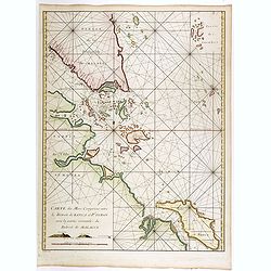
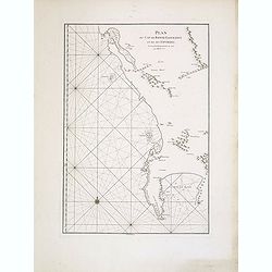
Nouvelle carte des mers comprises entre le détroit de Banca et P°. Timon avec la partie orientale du détroit de Malacca.
Important French chart of the tip of Malaysia with Singapore. Latitude and longitude scales, compass rose and system of rhumb lines, soundings near coast and in bay areas...
Place & Date: Paris, 1745
![ATLAS RUSSICUS mappa una generali et undeviginti specialibus vastissimum Imperium Russicum cum adiacentibus regionibus [repeated in French].](/uploads/cache/27877-250x250.jpg)
ATLAS RUSSICUS mappa una generali et undeviginti specialibus vastissimum Imperium Russicum cum adiacentibus regionibus [repeated in French].
After an unnumbered general map of Russia there are 13 numbered maps that cover European Russia (scale 1, 1.527.000). The other (last) 6 maps cover Asian Russia (Siberia,...
Place & Date: St Peterburg, Akademie von Wissenschaften. 1745
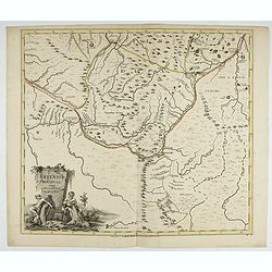
Uffensis Provincia Cum adiacentibus Regionibus.
Volga-Ural Region. From the first regional atlas of Russia, published by the Academy of Sciences in St. Petersburg, expanding on the cartographic work done previously by ...
Place & Date: Academy of Sciences, St. Petersburg, 1745
Casaniae Regnum cum Adiacentibus Provinciis et Parte Fluvii Volgae.
From the first regional atlas of Russia, published by the Academy of Sciences in St. Petersburg, expanding on the cartographic work done previously by Ivan K. Kirilov. Ou...
Place & Date: Academy of Sciences, St. Petersburg, 1745
Plan du Cap de Bonne-Esperance et ses environs..
Large and detailed sea chart of the Cape of Good Hope from Saldahna Bay to False Bay.Engraved by Guillaume-Nicolas Delahaye (1727-1802).Latitude and longitude scales, com...
Place & Date: Paris, 1745
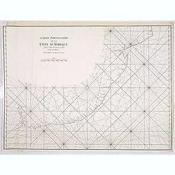
Carte particulière de la côte d'Afrique depuis le cap des Courans jusqu'à la baye de Ste Hélène. . .
Large and detailed sea chart of South Africa.Engraved by Guillaume-Nicolas Delahaye (1727-1802).Latitude and longitude scales, compass rose and system of rhumb lines, sou...
Place & Date: Paris, 1745
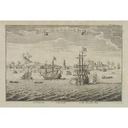
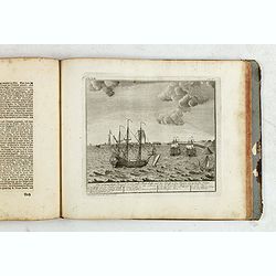
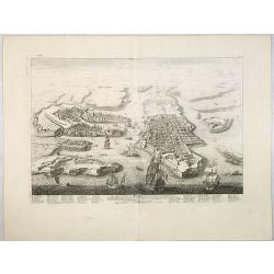
A view of the town and castle of Macao.
A nice engraving that shows the attack of the English ship "Centurion" on Macau, during which she captured a Portuguese ship that had sailed from Manila. In up...
Place & Date: London, 1746

A new and accurate map of Mexico or New Spain with California New Mexico . . .
With inset of Galapagos islands. A wonderfully engraved map showing the entire American South from Carolina to California, as well as all of Mexico and Central America. A...
Place & Date: London, 1747
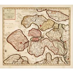
Kaart van Zeeland.
Fine map of the province of Zeeland, with the fortified cities are highlighted in red. Isaac Tirion was born in Utrecht ca. 1705. He came to Amsterdam ca. 1725. Tirion pu...
Place & Date: Amsterdam, 1747
A new & accurate map of Asia drawn from actual surveys. . .
An excellent early engraving of Asia. Curious shape for Japan, with a large island north called Yeso and a coastline marked De Gamma's Land. Numbered "No 52."; ...
Place & Date: London, 1747
Selling price: $750
Sold in 2024
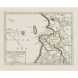
III. Carte de la Hollande.. Over-Yssel.
Attractive small map centered on the delta of the River Ijssel, where it discharges into the Zuiderzee.From Atlas Portatif Universel, by Robert de Vaugondy. Unrecorded st...
Place & Date: Paris, later than 1748
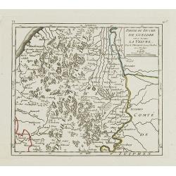
VI. Partie du Duche de Gueldre où se trouve la Veluwe.
Attractive small map covering the northwestern part of Gelderland. In the center "'t Loo". From Atlas Portatif Universel, by Robert de Vaugondy.Unrecorded state...
Place & Date: Paris, later than 1748
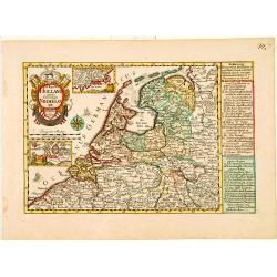
Die Republic Holland oder die Verenigte Niederlande..
Charming map of the Netherlands, with inset maps of Novi Belgium area in America and Indonesia. With a fine cartouche.
Place & Date: Leipzig 1749
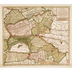
Nieuwe kaart van het oostelykste deel van Holland. . .
Detailed map covering the area of Gouda, IJsselstein, s'Hertogenbosch, Zevenbergen, Dordrecht.
Place & Date: Amsterdam, 1749
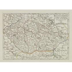
Royaume de Bohéme, Marquisat de Moravie, et Silésie Autrichenne.
Small detailed map of today Czech Republic. From Atlas Portatif Universel, by Robert de Vaugondy.Unrecorded state with erased date. Page 32 outside border top right. Mary...
Place & Date: Paris, later than 1749
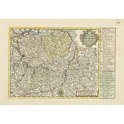
Das Hertzogthum Braband. . .
Charming map of the Dutch and Belgium province of Brabant. With a fine cartouche.
Place & Date: Leipzig, 1749
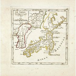
Le Japon.
The map is of interest for the use of Mer de Corée, for the sea between Korea and Japan. Small detailed map of Japan and Korea. Dated 1749. A note next to island &quo...
Place & Date: Paris, 1749
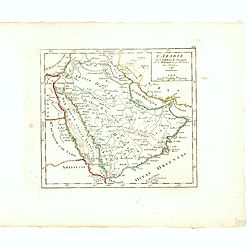
L'Arabie.
Small detailed map of the Arabian Peninsula. From Atlas Portatif Universel, by Robert de Vaugondy.Page 162 outside border top right.
Place & Date: Paris, later than 1749
![Kantong [The Dutch Folly Fort off Canton]](/uploads/cache/05714-250x250.jpg)
Kantong [The Dutch Folly Fort off Canton]
Charming 18th water color on paper depicting The Dutch "Folly Fort" off Canton. Probably made by a western artist visiting China.Forts were built in several pla...
Place & Date: Canton?, c.1750
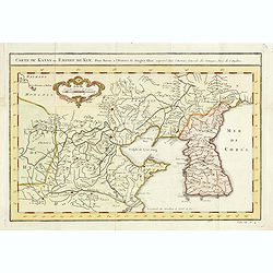
Carte du Katay, ou Empire de Kin : pour servir a l'Histoire de Jenghiz Khan, raportée dans l'Histoire generale des voyages, tirée de l'Angloise.
The map is of interest for the use of East Sea, the sea between Korea and Japan, here called "Mer de Corée".Fine map of Korea and China's Yellow Sea. Complete ...
Place & Date: Paris, 1750
Selling price: $450
Sold in 2023
Carte du Katay ou Empire de Kin. . .
The map is of interest for the use of Mer de Corée, for the sea between Korea and Japan .Fine map of Korea and China's Yellow Sea. Complete title in top: Carte du Katay ...
Place & Date: Paris, 1750
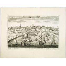
Vue de L'Hotel de Batavie. . .
A so-called optical print of Fatahillah Square in Jakarta, Indonesia, prepared for use in a light-box or an amusing light-show. This richly hand colored print is much per...
Place & Date: Augsburg, 1750
Middelbourg Ville la plus considerable de l'Isle de Walcheren et du Comté de Zelande l'une des huit provinces Unis des pais-bas . .
A very decorative and extremely rare of Middelburg, including a numbered (1-19) key in lower part. Published by Jacques Chéreau, (1688 - 1776). Engraved by Aveline and ...
Place & Date: Paris, ca.1750
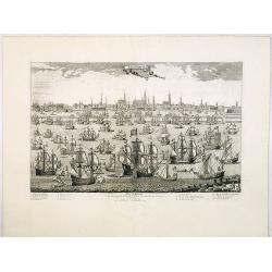
Amsterdam Ville du Comté de Hollande et la plus considerable des Provinces Unies. . .
A very decorative and extremely rare town-view of Amsterdam, including a numbered (1-18) key in lower part. Extensive shipping on the IJ. To the left the headquarters of ...
Place & Date: Paris, ca.1750
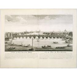
A view of Westminster bridge. Vue du pont Westminster.
A very decorative and extremely rare of river Themes and Westminster bridge in London, including a six-line description in French and English. Published by Jacques Chér...
Place & Date: Paris, ca.1750
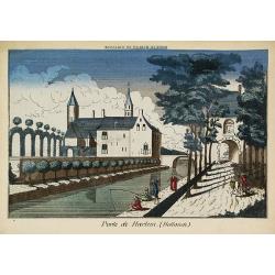
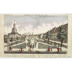
Porte de Harlem (Heemstede/Haarlem)
Showing the Haarlemmer Poort (gate) in Heemstede near Haarlem. Likely published by Mondhard, who was a well-known publisher of optical prints, established in rue St.Marti...
Place & Date: Paris, ca. 1750
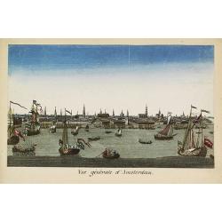
Vue générale d'Amsterdam.
A so-called optical prints, showing Amsterdam seen from the IJ. A lively scene with extensive shipping. To the left the headquarters of the V.O.C., nowadays the Maritime ...
Place & Date: Paris, ca. 1750
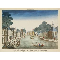
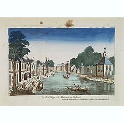
Vue du village de Maarsen en Hollande.
Showing the river Vecht at the town of Maarsen. Published by Jacques Chereau, who was a well-known publisher of optical prints, established in rue St. Jacques in Paris. I...
Place & Date: Paris, ca. 1750
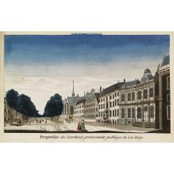
Perspective du Voorhout, promenade publique de La Haye.
Showing the Voorhout in The Hague. Likely published by Mondhard, who was a well-known publisher of optical prints, established in rue St.Martin in Paris. In the eighteent...
Place & Date: Paris, ca. 1750
Les Villes forts et châteaux de Malte capitale de l'isle de ce nom. Dessignée sur le lieu par un Ingr du roy.
A very decorative and extremely rare town-view of Valetta, including a numbered legend in lower part. Published by Jacques Chereau, (1688 - 1776). Engraved by Aveline and...
Place & Date: Paris, ca.1750
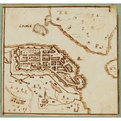
Cochin (today: Ernakulam)
Small but charming 18th water color on paper depicting Cochin (today : Ernakulam) was from 1500, when the first Portuguese fleet called on its port, a firm ally of the Po...
Place & Date: India? c.1750
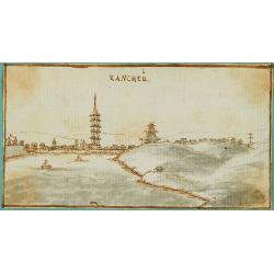
Kancheu.
Charming 18th water color on paper depicting Kancheu. Probably made by a western artist visiting China.
Place & Date: c.1750
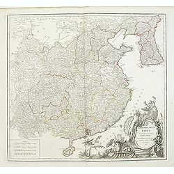
L'Empire de la Chine. . .
Detailed map of China, Korea and Taiwan. The large title cartouche is resplendent in the French style with musicians, a dancer, and various accouterments representative o...
Place & Date: Paris, dated 1750
Dynastiae Comitat. Schoenburgici Penig, Remissa, Rochsburg, Wechselburg In Clientela Elect: Saxon Glaucha, Hartenstein, Lichtenststein, Walkenburg. . .
A very uncommon and superbly decorative map of Lower Saxony, the region southwest of Dresden. Including the towns of Rochlitz, Geringswalde, Mittweida, Frankenberg, Chemn...
Place & Date: Augsburg, 1750
Vue du village de Maarsen en Hollande.
Showing the river Vecht at the town of Maarsen. Published by Jacques Chereau, who was a well-known publisher of optical prints, established in rue St. Jacques in Paris. I...
Place & Date: Paris, ca. 1750
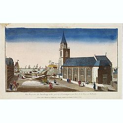
Vue perspective edu fauxbourg et du port de Scheveningue a une lieue de la Haye, en Hollande.
Optical print showing the village and harbor of Scheveningen with the church at the right, in the background the North Sea. In the background the summer residence Nieuw S...
Place & Date: Paris, ca. 1750
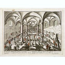
Per telecopium exhibitio partis inferioris armamentarii. / Representation en perspective de la partie inferieure d'un arsenal. . .
RARE. Engraved optical print by Georg Balthasar Probst of a arsenal.
Place & Date: Augsburg, 1750
't Hooge Heemraedschap van Delfland met alle de Steden, Dorpen, Ambachten, Litmaten, Polders, (etc.).
The so-called Kruquius map is a wall-map of the Delfland water board district. The map consists of 25 engraved map sheets. Several maps flanked by fine large armorial car...
Place & Date: Delft, 1712-1750
Carte du Katay ou Empire de Kin. . .
The map is of interest for the use of Mer de Corée for the sea between Korea and Japan .Fine map of Korea and China's Yellow Sea. Complete title in top: Carte du Katay o...
Place & Date: Paris, 1750
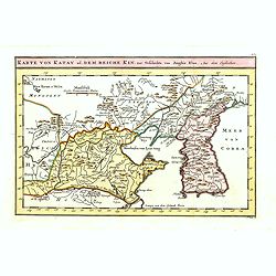
Karte von Katay od. dem Reiche Kin, zur Geschichte von Jenghiz Khan. Aus dem Englischen.
The map is of interest for the use of East Sea, the sea between Korea and Japan, here called "Meer von Corea".Copper engraving, hand colored in outline and wash...
Place & Date: Leipzig, Schwabe, ca. 1750
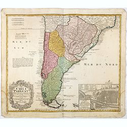
Typus Geographicus Chili Paraguay Freti Magellanici &c.
Detailed map covering the southern part of the continent based on the cartography of Delisle and the information gleaned from the voyages of Brouwer, Narbouroug and Beauc...
Place & Date: Nuremberg, 1750
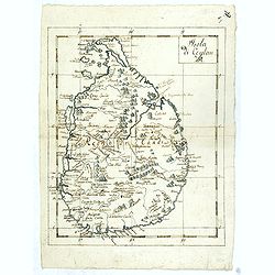
Isola Di Ceylan. (Manuscript map of Sri Lanka)
Manuscript map of Sri Lanka (Ceylon). Inland filled with a good number of place names, mountains.
Place & Date: Italy, ca. 1750

Plan de la ville de Siam.
Early plan of Siam, Thailand. Across the top is an extensive list of 22 important sites and locations keyed to the plan with tiny letters and numbers.Jacques Nicolaas Bel...
Place & Date: Paris, 1750
Nieuwe en zeer accuraate Zee-Caart van de Hollandse Wal strekkende van de Maas tot Texel opgenomen door Jan Rokusz Douw, , ,
A very fine and rare chart of the coast of Holland, Prepared by Jan Rokusz, Douw and Agge Roskam Kool.Embellished with a very decorative cartouche with a dedicational tex...
Place & Date: Amsterdam, 1750
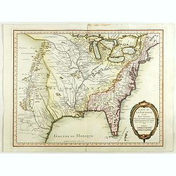
Carte de LA LOUISIANE et des PAYS VOISINS Dédiée a M. Rouillé Dediee a M. Rouille Secretairr 'd Etat ayant le Departement de la Marine... 1750
North America from the eastern seaboard to the Rocky Mountains. Based on Delisle's map of 1718 with additions from notes compiled by the Jesuit priest, explorer and histo...
Place & Date: Paris, 1750
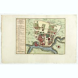
Plan de la ville de Louvo . . .
Early plan of Louvo city. Across the top is an extensive list of 22 important sites and locations keyed to the plan with tiny letters and numbers.Jacques Nicolas Bellin (...
Place & Date: Paris, 1750
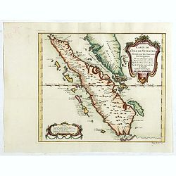
Carte de L'Isle de Sumatra Dressee sur les Journaux des Navigateurs . . .
Detailed map of Sumatra and Malacca, centered on Singapore and including the southern portion of the Malaysian peninsula. With "Detroit de Sincapour" and severa...
Place & Date: Paris, ca. 1750
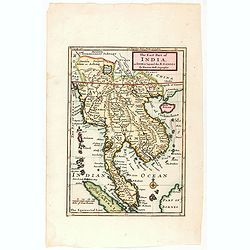
The East Part of India, or India beyond the R. Ganges.
Herman Moll's map of those Asian countries to be found east of the River Ganges, including Burma, Thailand, Vietnam, Laos, Cambodia, southern most China, Malaysia, Sumatr...
Place & Date: London, ca 1750
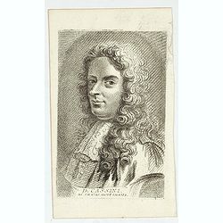
D. Cassini. Né en 1625. mort en 1712.
Very rare stipple engraved portrait of Jean Dominique Cassini. Dominique Cassini was the son of César-François Cassini de Thury, the grandson of Jacques Cassini and the...
Place & Date: Paris, ca. 1750
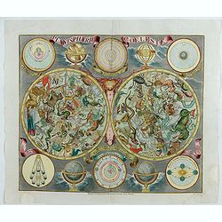
Planisphaerum coeleste.
A very decorative double hemisphere celestial chart. The 10 smaller circular diagram showing the rotation of the Planets, according to Tycho Brahe, Ptolemy and Copernicus...
Place & Date: Nurenberg, 1750
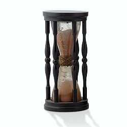
A ship's hour glass.
Maritime hourglass with blown glass bulbs, orange sand, junction ring covered with cord, the circular ebony frame with six turned baluster columns. The invention of the ...
Place & Date: Germany, ca. 1750
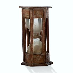
A ship's hour glass.
Maritime hourglass with blown glass bulbs, orange sand, junction ring covered with cord, the circular ebony frame with six turned baluster columns.The invention of the ho...
Place & Date: The Netherlands, Germany, ca. 1750
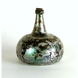
Wine bottle 9498
The Onion-shaped wine bottle is of green glass and is sealed with cork and wax that the cork holds in place. The many years that the bottles spent under the water have l...
Place & Date: Dutch East India Company, Netherlands, ca. 1735-1750
![[3 prints] Veduta della Piazza di S. Marco dall' Orologgio. / Veduta della Piazzetta. / Veduto della Piazza di S. Marco in Venezia.](/uploads/cache/63336-250x250.jpg)
[3 prints] Veduta della Piazza di S. Marco dall' Orologgio. / Veduta della Piazzetta. / Veduto della Piazza di S. Marco in Venezia.
Set of 3 Mezzotint-engravings of Venice engraved and published in Augsburg by Christoph Gustav Kilian.Christoph Gustav Kilian (Augsburg 1724-1776). Member of the extended...
Place & Date: Augsbourg, ca. 1750
![[Set of 3 optical prints] Vue du Pallais du l'Empereur de Perse avec la Mosquée, ou Eglise a Ispahan.](/uploads/cache/49123-250x250.jpg)
[Set of 3 optical prints] Vue du Pallais du l'Empereur de Perse avec la Mosquée, ou Eglise a Ispahan.
An optical print of the court of the Persian Emperor. Engraved by F.X. Habermann (1721-1796). The Academie Imperiale was a well-known publisher of optical prints establis...
Place & Date: Augsburg, 1750
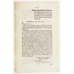
Extract uit de Resolutien door Heeren Bewindhebberen der Oost-Indische Compagnie gecommitteerd ter Vergadering van 17e binnen Amsterdam genomen op Donderdag
Contains a list of resolutions dated from 27th November 1783 and reports about the dumping of oil, tar etc. into the sea.
Place & Date: Amsterdam, 1751
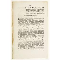
Extract uyt de Resolutien, door de Vergadering der Heeren Zeventienen, van de Generale Nederlandsche O. I. Compagnie binnen Amsterdam, genomen op Woensdag den 2 April 1774.
Contains a list of resolutions dated from 2nd April 1774 and concerning health care. Boarding crew had to be examined by the ship's surgeon. People with illnesses were to...
Place & Date: Amsterdam, 1751
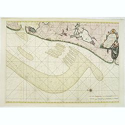
Nieuwe Wassende Graadige Pas-kaart van de Kust van Guinea en Brasilia.
Rare two-sheet sea chart of the coasts of Brazil, West Africa and South Africa, published by Johannes Van Keulen (the younger), circa 1720.The chart shows the western coa...
Place & Date: Amsterdam, 1751
![[Complete set of maps of Japan] Imperium Japonicum Per Regiones Digestum Sex et Sexaginta Atque Ipsorum Japonensium Mappis Descriptum Ab Hadriano Relando.](/uploads/cache/41590-250x250.jpg)
[Complete set of maps of Japan] Imperium Japonicum Per Regiones Digestum Sex et Sexaginta Atque Ipsorum Japonensium Mappis Descriptum Ab Hadriano Relando.
Complete set of 11 maps Reland's map of Japan, the first map to use Sino-Japanese characters on a European printed map and represents a radical departure from prior Europ...
Place & Date: Amsterdam, 1751

Plan de la Baye de Manille. / Plan van de Baay van Manilla.
Detailed plan of Manila Bay after George Anson's key plan of the Bay of Manila. With a compass rose and soundings in the Bay. East to the top.This is the rare Dutch editi...
Place & Date: Amsterdam, Arkstee and Merkus, 1751
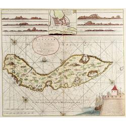
Nieuwe Afteekening van het Eijland Curaçao..
Decorative and extremely rare chart of Curaçao with several coastal insets and an inset of Fort Amsterdam and the Bay of St.Anna (127x135mm.)Besides the island of Curaca...
Place & Date: Amsterdam, 1751
![[ Hong Kong / Canton ] Nieuwe Pas=Caart strekkende van Pta Cataon tot Pta. Lamtoan, langs de kusten van Cochinchina, Tonquin, Quangsi en Quantung [?] van Macao.](/uploads/cache/24951-250x250.jpg)
[ Hong Kong / Canton ] Nieuwe Pas=Caart strekkende van Pta Cataon tot Pta. Lamtoan, langs de kusten van Cochinchina, Tonquin, Quangsi en Quantung [?] van Macao.
A finely engraved and detailed chart of Vietnam reaching to Macao and present-day Hong Kong..Very rare: only included in the 6th volume (so-called secret atlas) of Van Ke...
Place & Date: Amsterdam, 1753
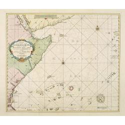
Pas-Kaat vaneen gedeelte van de Aethiopische Zee behelsende de Kusten Zanguebar, Ajan en Abex, en een gedeelte van de Arabische Kust. . .
A finely engraved and detailed chart of the most eastern tip of Africa, including Somalia, Djibouti, Yemen, Mauritius, and many other islands in the Indian Ocean.Very rar...
Place & Date: Amsterdam, 1753
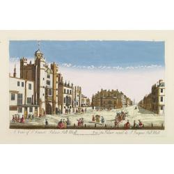
A View of S. James's Palace Pall Mall. - Vues du Palais royal de S.Jacques Pall Mall.
So-called optical print illustrating a perspective view of St James's Palace, Pall Mall. The gatehouse of St James's Palace is on the left.In the eighteenth and nineteent...
Place & Date: Paris, 1753
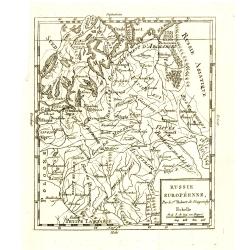
Russie Européenne . . .
Detailed map of European part of Russia, including Finland and Lapland.Gilles Robert de Vaugondy (1688–1766), also known as Le Sieur or Monsieur Robert, and his son, Di...
Place & Date: Paris, ca. 1753
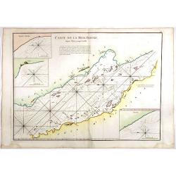
Carte de la Mer Rouge, depuis Moka jusqu's Gedda. . . .
Chart of the Red Sea. With 3 inset maps of Shake Omare, Goofs and Gedan. D'Après De Mannevillette (1707-1780) was one of France's first hydrographers. When the first edi...
Place & Date: Paris, 1753
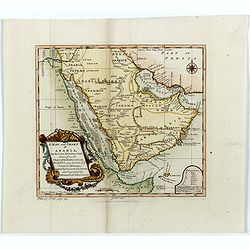
A Map and Chart of Arabia, the Red Sea, & Persian Gulf, drawn from the Chart of the Eastern Ocean, Publish'd in 1740, by Order of ye Count de Maruepas,...
A small but unusual map of the Arabian Peninsular, engraved by G. Child for 'The universal traveller: or, A compleat description of the several nations of the world', by ...
Place & Date: London, Th. Salmon, 1752-1753
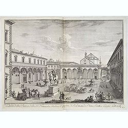
Veduta della Piazza della SS. Nunziata, Statua Equestre di Ferdinando Primo, Fonti, e Loggie Laterali.
Lively view of Nunziata square with the statue of Ferdinand I in Florence after Giuseppe Zocchi (1711or 1717 - 1767) and engraved by B.Sgrilli. From "Scelta di XXIV ...
Place & Date: Florence, Bouchard, 1754

Mappemonde contenant les parties connues du globe terrestre dressée suivant de nouvelles observations
Wall map of the world in two hemispheres printed on two sheets, depicting the Eastern and Western hemispheres supported by two male figures, decorated at the bottom right...
Place & Date: Paris, Longchamps et Janvier, 1754
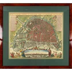
Amstelodami veteris et novissimae urbis accuratissima deline
A decorative plan of the town with at left and right legends mentioning the most important buildings and streets. At bottom center a view of the town from 't IJ. From Atl...
Place & Date: Amsterdam, 1745-1754
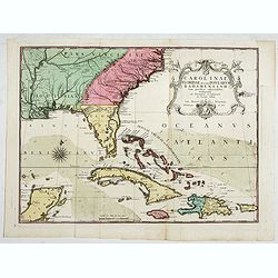
Carolinae Floridae nec non Insularum Bahamensium cum partibus adjacentibus delinatio ad Exemplar Londinense in lucem edita . . . Ao. 1755.
The German edition of this map of Carolina, Florida, and the Bahama Islands in full original colors. Published in Seligmann's "Sammlung verschiedener auslaendischer ...
Place & Date: Nuremberg, 1755