Browse Listings in Europe
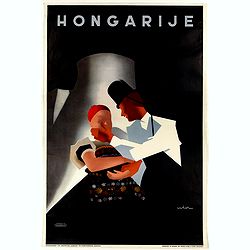
Hongarije.
Poster made for Hungarian Tourist association. The uncommon Dutch version of this fine poster to promote Hungary in the 1930's. Arisztid Uher was a graphic designer. He d...
Place & Date: Budapest, KLOSZ / Sohn., ca. 1930

(Art déco gouache with winter scene of The Palace of Westminster )
Outstanding "art deco" gouache (unsigned) from the workshop of "Robert Pichon. Ateliers de Dessin et Lithographie – 10, rue Rochechouart – Paris. The ...
Place & Date: Paris, ca. 1930
![[Venice]](/uploads/cache/49149-250x250.jpg)
[Venice]
Lovely art deco pochoir showing Venice at night, with gondolas, the moon and the city in the back.Pochoir is a technique that was often used in French Fashion Journals to...
Place & Date: Paris, ca. 1930
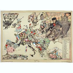
L'Europe en Sept 1939. Ille terrarum mihi angulus ridet.
A rare oversized serio-comic map of Europe at the start of the Second World War depicting stereotypes of 31 countries, as listed in the key lower right, including Brit...
Place & Date: Bruges, Leon Burghgraeve, 1939
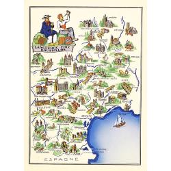
Languedoc - Foix Roussillon.
Very decorative, informative map of Languedoc - Foix Roussillon region in south eastern France. Including the towns of Carcassonne, Montpellier, Albi, Toulouse, etc.The m...
Place & Date: France, 1943
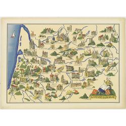
Guyenne - Gascogne.
Very decorative, informative map of Guyenne and Gascogne region in France. The map is filled with buildings, animals, figures and two locals. With a large compass rose in...
Place & Date: France, 1943
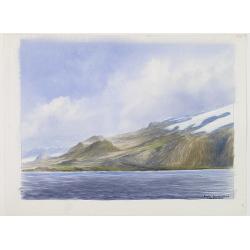
Group of 21 watercolors of scenes in Iceland, included are vulcanos like Eyjafjallajokull, Öræfajökull, etc.
A group of water colors made during visits of the artist F. de Boungne to Iceland, among them are contemporary artistic impressions of the now world-famous volcano Eyjafj...
Place & Date: Iceland, 1933-1944
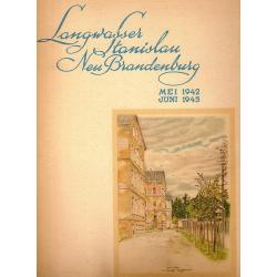
Langwasser Stanislau Neu Brandenburg Mei 1942 Juni 1945
Map met reproducties van crayontekeningen van Krijgsgevangenschap in Langwasser, Stanislau en Neu-Brandenburg, Mei 1942 -juni 1945.Uitgegeven april 1948 door het Minister...
Place & Date: Den Haag, April 1948
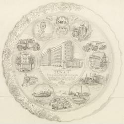
Shell : 9 Februari 1911-1951.
Decorative design-drawing in lead pencil offered to mr. J.E. Talens for his 40 years jubilee at the Shell foundation : Aangeboden aan J. E. Talens ter gelegenheid van zij...
Place & Date: Gouda, ca. 1951
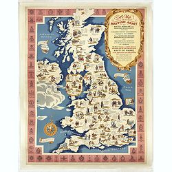
A map of the British Army with battle honours and militray achievements and Regimental Badges . . .
Shows English County Regiments, Battle Honours and Military Achievements. Bordered by Regimental Badges.A fascinating piece of British history.Read more about Pictorial M...
Place & Date: London, 1952
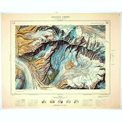
Aiguille verte - Chamonix N°6 Sud
Magnificent 1:10,000 scale color printed map of l'Aiguille verte (Chamonix N°6 Sud) based on stereotopographic ground and aerial surveys carried out in the field in 1950...
Place & Date: Paris, 1953
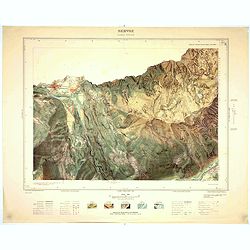
Servoz - Cluses N°8 Sud.
Magnificent 1:10,000 scale color printed map of Servoz (Cluses N°8 Sud) based on stereotopographic ground and aerial surveys carried out in the field in 1950 and render...
Place & Date: Paris, 1953
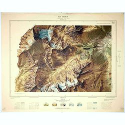
Le Buet - Chamonix N°1 Sud. / Massif des Aiguillles Rouges.
Magnificent 1:10,000 scale color printed map of Le Buet (Chamonix No. 1 South) / "Massif des Aiguilles Rouges" based on stereotopographic ground and aerial surv...
Place & Date: Paris, 1953
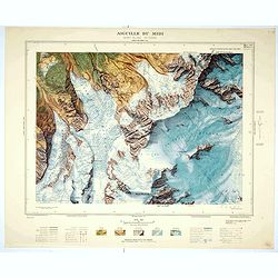
Aiguille du Midi - Mont Blanc N°1 Nord.
Magnificent 1:10,000 scale color printed map of L'Aiguille du Midi (Mont Blanc N°1 Nord) based on stereotopographic ground and aerial surveys carried out in the field in...
Place & Date: Paris, 1953
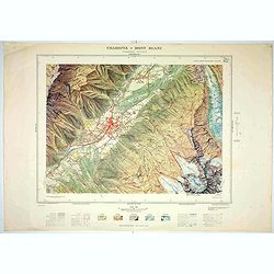
Chamonix - Mont Blanc - Chamonix N°5 Sud.
Magnificent 1:10,000 scale color printed map of Chamonix - Mont Blanc (Chamonix N°5 Sud) based on stereotopographic ground and aerial surveys carried out in the field in...
Place & Date: Paris, 1953
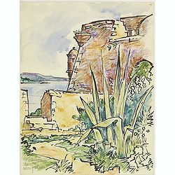
Forteresse Ile Ste Marguerite.
Nice drawing of a stronghold Ste Marguerite. The Île Sainte-Marguerite is the largest of the Lérins Islands, about half a mile off shore from the French Riviera town of...
Place & Date: France, Provence, after 1960
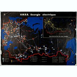
U.R.S.S. Energie Eléctrique. (5)
Map of Russia. Publicity poster for Russia's electrical production. Text in French. Editions de l'Agence de presse Novosti".More about War Maps & Propaganda maps...
Place & Date: USSR, 1978