Browse Listings in Europe
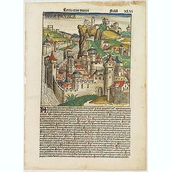
![[Page with imaginary towns in Hungary. ] CCLXVIII](/uploads/cache/26932-250x250.jpg)
[Page with imaginary towns in Hungary. ] CCLXVIII
Page with imaginary towns in Hungary (230x225mm.) This leaf is from an edition of Hartmann Schedel's Liber chronicarum or Nuremberg Chronicle. The Chronicle was published...
Place & Date: Nuremberg, 1493
![Sexta Etas Mundi. Ratisbonna. [Ratisbonne]](/uploads/cache/13549-250x250.jpg)
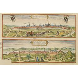
Sexta Etas Mundi. Ratisbonna. [Ratisbonne]
A very fine presentation of the city of Ratisbon, in Germany, centered on the cathedral (Dim. : 191 mm W : 525 mm).Overleaf a very nice view of Vienna, with two swans on ...
Place & Date: Nuremberg, 12 July 1493
![Venecie. [Venice] Foliu XLIIII](/uploads/cache/29716-250x250.jpg)
Venecie. [Venice] Foliu XLIIII
A very fine of Venice (192x525mm.) Verso a view of Padua. Schedel's view of Venice is one of the earliest obtainable views of the city. The view is based on the view of ...
Place & Date: Nuremberg, 12 July 1493
![Basilae [ Basle, CCXLIIII ]](/uploads/cache/29714-250x250.jpg)
Basilae [ Basle, CCXLIIII ]
A very fine view of Basle (253x520 cm). Verso showing the councils of Florence and Basle and two portraits.Page from the richest illustrated Incunabel, the famous: Nuremb...
Place & Date: Nuremberg, 12 July 1493
![Ulma Folio CXCI [With view of Ulm.]](/uploads/cache/29713-250x250.jpg)
Ulma Folio CXCI [With view of Ulm.]
Double-page panoramic view of Ulm.An imaginary view, however, is the earliest obtainable view of this period.Two pages from the richest illustrated Incunabel, the famou...
Place & Date: Nuremberg, 12 July 1493
Tercia Etas Mundi. Folium.XLVI (A English town view)
Large woodcut depicting an imaginary English town (235x223mm.) and on verso the genealogy of King David.Page from the richest illustrated Incunable, the famous: Chronicle...
Place & Date: Nuremberg, 12 July 1493
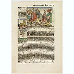
Sexta Etas Mundi. Folium. CCXVII (dancers of Maastricht).
Latin text page with woodcuts of male Siamese twins, a man headed lion. The large illustration is the only illustration related to the Netherlands : it shows a bridge col...
Place & Date: Nuremberg, 12 July 1493
Selling price: $450
Sold in 2024
![Sexta Etas Mundi. Constancia. [Constance CCXLI ]](/uploads/cache/33141-250x250.jpg)
Sexta Etas Mundi. Constancia. [Constance CCXLI ]
A very fine town view of Constance, in Germany, centered on the cathedral (198 x 520 mm).VERSO, seven insets of scientists, noblemen and Popes.Page from the richest illus...
Place & Date: Nuremberg, 12 July 1493
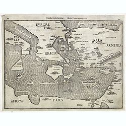
(EUROPE).
The map of Europe has been identified as the work of Hieronimus Münzer (1437-1508), a Nuremberg physician who supplied the geographical contents of the chronicle. The Eu...
Place & Date: Nuremberg, 1493
![Quarta etas mudi Folio LVIII [Rome]](/uploads/cache/48488-250x250.jpg)
Quarta etas mudi Folio LVIII [Rome]
Double text page in German with a woodblock Rome (23x53cm.)On verso a view of Genua (193x222mm). Page from the richest illustrated Incunable, the famous: Nuremberg Chro...
Place & Date: Nuremberg, 12 July 1493
![Quarta Etas Mndi. Carvilium / Aquileya. [Carovilli and Aquileia]](/uploads/cache/13525-250x250.jpg)
Quarta Etas Mndi. Carvilium / Aquileya. [Carovilli and Aquileia]
A lovely presentation of Carovilli, in the province of Cremona. Recto, a view of the town of Aquileya in Italy, centered on the castle and the high walls. Aquileia is an ...
Place & Date: Nuremberg, 12 July 1493
![Bamberga. Folium CLXXV [Bamberg]](/uploads/cache/47606-250x250.jpg)
Bamberga. Folium CLXXV [Bamberg]
Double page panoramic view of Bamberg. One of the earliest obtainable view of this period.Two page from the richest illustrated Incunable, the famous: Nuremberg Chronicl...
Place & Date: Nuremberg, 12 July 1493
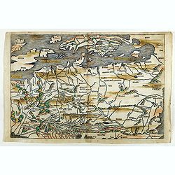
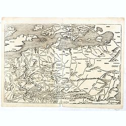
(EUROPE).
A woodcut colored map of northern and central Europe. The first modern map of the area. Second printed map of the North, after the woodcut map published in the 'Ulm' Ptol...
Place & Date: Nuremberg, 1493
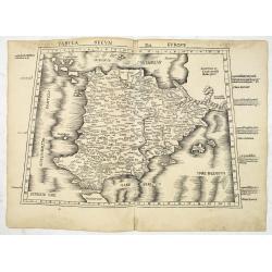
Tabula Secunda Europe (Spain & Portugal)
Wood block printed large-format Ptolemaic map of the Iberian Peninsula from the 1513 edition of Waldseemüller's Geographia.This Ptolemaic map comes from the first so cal...
Place & Date: Strasburg, 1513
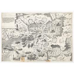
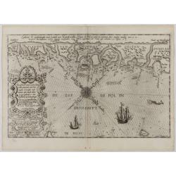
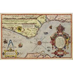
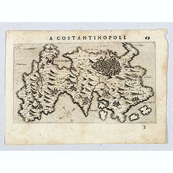
La dimostratione del luogo dove al presente sitrova l'armat di Barbarossa, et de Christiani detto il golfo dell 'Artha anti ch amente il sino ambracio…
The title cartouche at the top left reads: "La Dimostratione Del Luogo Dove Al Presente Sitrova L'Armat Di Barbarossa, et De Christiani Detto Il Golfo Dell' Artha An...
Place & Date: Rome, c. 1540
![[Europe, Eastern, Sarmatia, Ukraine]](/uploads/cache/33854-250x250.jpg)
[Europe, Eastern, Sarmatia, Ukraine]
Wood block printed map and one of earliest printed representation of Europe, Eastern, Sarmatia, Ukraine prepared L. Fries after Martin Waldseemüller.Based on the slightl...
Place & Date: Vienna, Trechsel, G., 1525 -1541
![.[Balkan region with Austria, Croatia, Slovenia, Switzerland, etc]](/uploads/cache/33858-250x250.jpg)
.[Balkan region with Austria, Croatia, Slovenia, Switzerland, etc]
Wood block printed map and one of earliest printed representation of Balkan with Austria, Croatia, Slovenia, Switzerland, etc prepared Martin Waldseemüller. Based on the...
Place & Date: Vienna, 1525 -1541
![.[Germany and Poland]](/uploads/cache/33862-250x250.jpg)
.[Germany and Poland]
Wood block printed map and one of earliest printed representation of Germany, Poland, The Low Countries, Austria and Switzerland prepared by Martin Waldseemüller. Based ...
Place & Date: Vienna, Trechsel, G., 1525 -1541
![[Albania, Bulgaria, Europe, Eastern, Greece, Hungary, Macedonia, Romania]](/uploads/cache/33868-250x250.jpg)
[Albania, Bulgaria, Europe, Eastern, Greece, Hungary, Macedonia, Romania]
Wood block printed map and one of earliest printed representation of Albania, Bulgaria, Europe, Eastern, Greece, Hungary, Macedonia, Romania prepared Martin Waldseemülle...
Place & Date: Vienna, Trechsel, G., 1525 -1541
![.[Georgia (Republic), Sarmatia, Ukraine]](/uploads/cache/33870-250x250.jpg)
.[Georgia (Republic), Sarmatia, Ukraine]
Wood block printed map and one of earliest printed representation of Georgia (Republic), Sarmatia, Ukraine prepared by Martin Waldseemüller. Based on the slightly larger...
Place & Date: Vienna, Trechsel, G., 1525 -1541
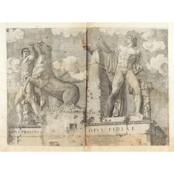
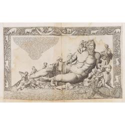
Opus Praxitelis, Opus Fidiae.
Opus Praxitelis, Opus Fidiae [Work of Praxiteles, Work of Fidias]. With the Lafreri's imprint and date. Published in the "Speculum Romanae Magnificentiae" (The ...
Place & Date: Rome, Antonio Lafreri, 1546

Panthei Fidelissime Dimensi Exterior et Interior…
The print features the Pantheon in Rome, broken away to show the interior. Complete title : " Panthei Fidelissime Dimensi Exterior et Interior pars ex antiquo romano...
Place & Date: Rome, Antonio Lafreri, 1553
Disegno dell Isola di Malta con li porti et forti… In Roma per Antonio Lafreri nel anno 1565.
The map includes a title cartouche with a lettered-key A-P and imprint at the top left and a scale decorated with a compass at the lower left.The second state of Antonio ...
Place & Date: Rome, 1565
Selling price: $4000
Sold in 2025
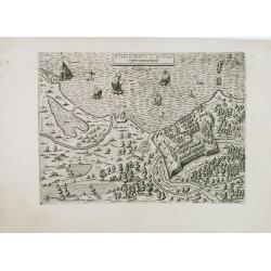
![[Two plates on one sheet] Ordinanza Turchesa alla presa di Zigeth in Ongaria l’anno 1566 / Ordinanza Turchesca sotto Viena, contra lo Invictißimo Imperatore Carlo quinto l'anno 1550.](/uploads/cache/49073-250x250.jpg)
[Two plates on one sheet] Ordinanza Turchesa alla presa di Zigeth in Ongaria l’anno 1566 / Ordinanza Turchesca sotto Viena, contra lo Invictißimo Imperatore Carlo quinto l'anno 1550.
Ordinanza Turchesca sotto Viena, contra lo Invictißimo Imperatore Carlo quinto l'anno 1550". C. 1560. This extremely rare plate depicts the order of battle and for...
Place & Date: Venice, 1550/ 1566
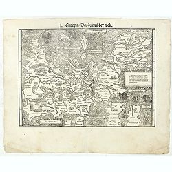
I Europa / Das dritteil der Welt.
Very early wood cut printed map of Europe with South to the top. In the lower-left corner we see Poland, Livonia and parts of England and Ireland in the lower right corne...
Place & Date: Zurich, Christoffel Froschover, 1548,1552-1566
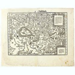
( II Germania) / Tütschland.
Very early wood cut printed map of Germany, Poland, The Low Countries, Alsace and part Europe with of Switzerland, Croatia. Originally engraved in 1548. Included in "...
Place & Date: Zurich, Christoffel Froschover, 1548,1552-1566
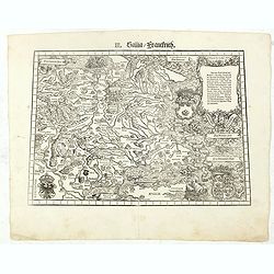
III. Gallia. Franckrych.
Very early wood cut printed map of France, North of river Rhine, Northern Italy. Coast of England from Dover to Cornwall. A ship, sea monsters and coats of arms are filli...
Place & Date: Zurich, Christoffel Froschover, 1548,1552-1566
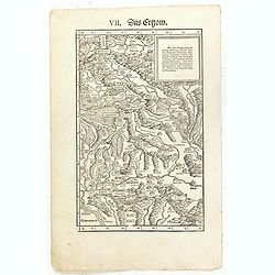
VII. Das Ergow.
Very early wood cut printed regional map of Switzerland centered on Ergow.Originally engraved in 1548. The map was prepared by Johannes Stumpf (1500-1576). Included in &q...
Place & Date: Zurich, Christoffel Froschover, 1548,1552-1566
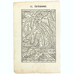
IX. Die Lepontier.
Very early wood cut printed regional map of Switzerland.Originally engraved in 1548. The map was prepared by Johannes Stumpf (1500-1576). Included in "Landtaflen. Hi...
Place & Date: Zurich, Christoffel Froschover, 1548,1552-1566
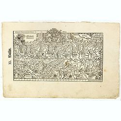
XI. Wallis.
Very early wood cut printed regional map of Switzerland with Wallis region.Originally engraved in 1548. The map was prepared by Johannes Stumpf (1500-1576). Included in &...
Place & Date: Zurich, Christoffel Froschover, 1548,1552-1566
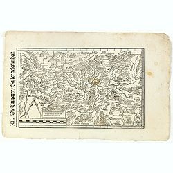
XII. Laurater Basler gelegenheit.
Very early wood cut printed regional map of Switzerland with Basel region.Originally engraved in 1548. The map was prepared by Johannes Stumpf (1500-1576). Included in &q...
Place & Date: Zurich, Christoffel Froschover, 1548,1552-1566
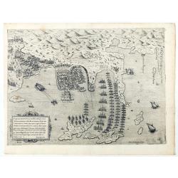
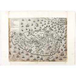
Disegno dove al presente si ritrova l'armata della santa legha contro la turchesca, nel promontorio della Morea dirincontro a Modon, dove l'armata nemica si è retirata… VI.Ottobre.1572.
Disegno dove al presente si ritrova l'armata della santa legha contro la Turchesca, nel promontorio della Morea dirincontro a Modon dove l'armata nemica si e retirata, lu...
Place & Date: Rome, 1572
Veterum Monumentorum Studiose Lector.../...Ant Lafreri aenea tabula nunc profert ex antiquo simulachro quod in vaticano adhuc conspicitur exacte effigiata.
The print feaures the Personification of the Nile, reclining, with an Egyptian sphinx and a cornucopia, after a Roman group in the 16th century installed as a fountain in...
Place & Date: Rome, Antonio Lafreri, ca. 1573
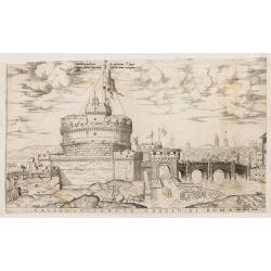
Castello Sancto Angelo di Roma.
The print features the Castello Sant' Angelo in Rome, bound in an album, perhaps from the "Speculum Romanae Magnificentiae." Copper engraving and published by A...
Place & Date: Rome, Antonio Lafreri, ca. 1573
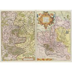
Franciae orientalis../ Monasteriensis et osnaburgensis..
From 'Theatrum Orbis Terrarum [Atlas of the Whole World]' published in Antwerp. French text on verso.The map of Frankenland is prepared by Sebastian Rotenhan (1478-1532) ...
Place & Date: Antwerp, c.1574
![Naumaohiae [sic] id est navalis pugnae ex vetusteis lapidum et nummorum monumenteis graphica deformatio.](/uploads/cache/49142-250x250.jpg)
Naumaohiae [sic] id est navalis pugnae ex vetusteis lapidum et nummorum monumenteis graphica deformatio.
Naval engagement set inside an arena, spectators in the stands attending the event; reclining river god and nymphs in the lower part. From "Speculum Romanae Magnific...
Place & Date: Rome, ca. 1575

Thusciae Descriptio Auctore Hieronimo Bellarmato.
Decorative and detailed map of Tuscany, from the 1574 or 1575 Latin text edition of Ortelius' Theatrum Orbis Terrarum, the first modern atlas of the world. The map is bas...
Place & Date: Antwerp, 1574-1575
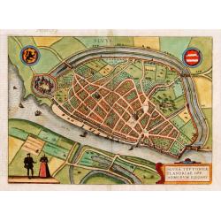
Slusa, Teutonicae Flandriae opp. . . (Sluis)
Bird'eye view of the town of Sluis.From the greatest publication in this genre!. The Civitates was compiled and written by George Braun, Canon of Cologne Cathedral. Braun...
Place & Date: Cologne, 1580
Vienna.. / Buda..
Pair of views on one sheet, the first showing the Austria capital of Vienna with fields, and figures in the foreground.Lower view shows the Hungarian capital of Budapest....
Place & Date: Cologne 1580
Descrittione di M. Lodovico Guicciardini patritio Fiorentino, di tutti i Paesi Bassi,...
Second Italian edition (variant B) and first Plantin edition (1st Silvius 1567) and the most sought-after edition of the famous description of the Low Countries, updated ...
Place & Date: Antwerp, Plantin, 1581
Tafel der Lender darin der Apostel Paulus geprediget hat.
Rare wood block map depicting the Mediterranean, with an over-sized Cyprus from the final Dutch edition of Heinrich Bünting's famous Itinerarium Sacrae Scripturae, a boo...
Place & Date: Magdeburg, 1581
![Traiectum ad Mosam. [Maastricht]](/uploads/cache/47901-250x250.jpg)
Traiectum ad Mosam. [Maastricht]
A birds-eye view of Maastricht seen from the south. Rising on Vrijthof square is the dominant complex of Sint-Servaas, in front of which - seen here in a distorted perspe...
Place & Date: Cologne, ca. 1581
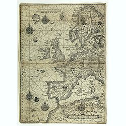
Universe Europae Maritime Eiusque Navigationis Descriptio. Generale Pascaerte van Europa . . .
This general chart of north-western Europe and the surrounding coastal waters is from the rare pilot-guide De Spiegel der Zeevaerdt , printed by Christopher Plantin in Le...
Place & Date: Leyden, 1584
![Anverpia, nobile in Barbantia oppidum, parrim maritimum . . . [Antwerp]](/uploads/cache/26518-250x250.jpg)
Anverpia, nobile in Barbantia oppidum, parrim maritimum . . . [Antwerp]
The bird's-eye plan provides an excellent view of the citadel, city, docks and fortifications. The city was defended by a line of fortification and a moat constructed und...
Place & Date: Cologne, 1585
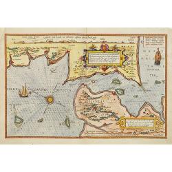
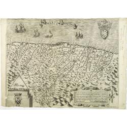
De Zee-Kuste vant Landt te Noort-oosten sorterende onder Norweghen ende eendeels onder Sweden alsoe tlandt aldaer in zijn gedaente is, van Distelberch tot Waersberghe.
A rare Latin text edition of this early and detailed chart of the coast of Norway of this landmark contribution to the science of navigation. Decorated by a large title c...
Place & Date: Leiden, Plantijn, 1585
Zee caerte vande Sondt tvermaerste van Danemarcke . . .
A detailed chart of the coast of Denmark and its islands, Copenhagen in the center of the chart. West to the top. It is decorated by a title, scale and descriptive cartou...
Place & Date: Leiden, Plantijn, 1585
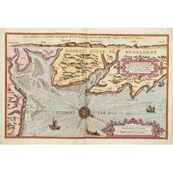
Belchrijuinghe vande zee custen van Engelandt. . .
A rare Dutch text edition of this detailed early chart of the northern coast of England. West to the top. The mileage cartouche has no Latin captures. Decorated by a colo...
Place & Date: Leiden, Plantijn, 1585
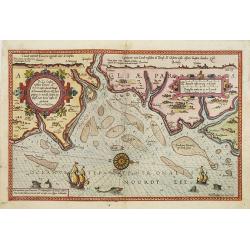
De zee cuften tufschen Dovere en Orfords nesse, daer de Teemse de Vermaerde Rivire van Lonen gelegens is. . .
A detailed chart of the English Channel coastland. Decorated by a colorful title cartouche and scale cartouche, one compass rose, several vessels and sea monsters. A very...
Place & Date: Leiden, Plantijn, 1585
Beschrijvinge vande de zee Cuften va Vlanderen en Picardien. . .
DUTCH TEXT EDITION. A detailed chart of the coast of Flanders and Normandy decorated by a large colorful baroque title cartouche, and the coat of arms of Flanders with a ...
Place & Date: Leiden, Plantijn, 1585

Descriptio Germaniae Inferioris.
The oval map is surrounded by a strapwork frame and the title, adorned with ribbons, is held aloft by two winged cherubs.According to P. Meurer based on de Jode's 12 shee...
Place & Date: Antwerp, 1587
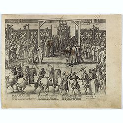
The hanging of the head of police Jean Grauwels in Brussels, 11 february 1569.
Print relating to Brussels during the first decades of the eighty year war between Spain and the Low Countries: (plate 18). This plate shows the hanging of the head of po...
Place & Date: Cologne, ca. 1590
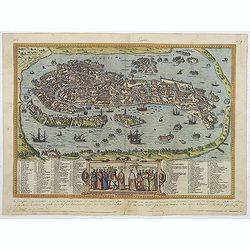
Venetia. (Venice)
Precise, beautiful bird's-eye town-view of Venice, clearly depicting the city's architectural landmark. The surrounding lagoon is animated with a great variety of sailing...
Place & Date: Cologne, 1590
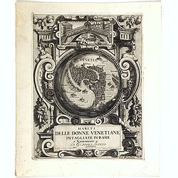
Habiti delle Donne Venetiane . . .
Title page of the book Habiti delle Donne Venetiane" (Dress of Venetian Women) which consists of twenty numbered plates of ornately dressed women. This very decorati...
Place & Date: Venice, ca. 1591
![[Spain and Portugal]](/uploads/cache/47718-250x250.jpg)
[Spain and Portugal]
A rare map of Spain and Portugal engraved by Jan and Lucas van Deutecom and published by Gerard de Jode, Antwerp 1593. Latin text on verso.The map appeared in the second ...
Place & Date: Antwerp, 1593
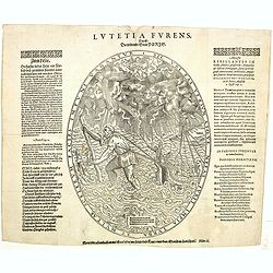
Lutetia Furens. Das ist : Die wütende Statt PARIS.
Rarissime placard dirigé contre la Ligue et le duc de Mayenne. La gravure est signée I.S. (marque inconnue). Ce placard en latin et en allemand est une reprise de l’e...
Place & Date: France ca.. 1594
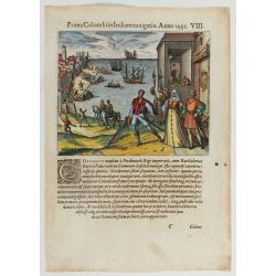
Prima Columbiin Indiam navigation Anno 1492.
Christopher Columbus and the Pinzon brothers leaving the port of Palos in Spain on August 3, 1492 for the New World. Right The King and Queen of Portugal Catholic Ferdina...
Place & Date: Frankfurt, 1594
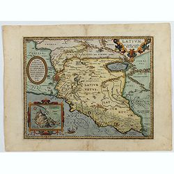
Latium.
Based on classical authors' sources, specifically Virgilius, Plinius, Varro, Halicarnasseus, Festus and Ausonius.Philip Wingius in his letter to Ortelius from 1592 mentio...
Place & Date: Antwerp, 1595
Nova et recens emendata totius Regni Ungariae una cum adiacentibus et finitimis regionisbus delineatio.
Engraved map by Jan van Deutecum, here the very rare first edition published by Cornelis Nicola in Asterdam in 1596. In very attractive original coloring.A re-issued was ...
Place & Date: Amsterdam, Cornelius Nicol, 1596
Florentini Dominii Fidelissima et nova descriptio.
The map is centered on the city of Florence and extends to Liguria, the Apennine Mountains, the Adriatic Coast, Siena and Lago di Perugia. The map is based upon Stefano B...
Place & Date: Anvers, 1598
![[ Map of the island Nexos]](/uploads/cache/45289-250x250.jpg)
[ Map of the island Nexos]
Very rare map of the island Naxos published in the first edition of "Viaggio da Venetia, a Costantinopoli. Per Mare, e per Terra, & infieme quello di Terra Santa...
Place & Date: Venice, Giacomo Franco, 1598
![[Map of Corfu. View of the city of Corfu on the foreground. ]](/uploads/cache/45221-250x250.jpg)
[Map of Corfu. View of the city of Corfu on the foreground. ]
Very rare map of Corfu with a view of the city of Corfu on the foreground. Published in the first edition of "Viaggio da Venetia, a Costantinopoli. Per Mare, e per T...
Place & Date: Venice, Giacomo Franco, 1598
![Candia [Map of the island Crete]](/uploads/cache/45233-250x250.jpg)
Candia [Map of the island Crete]
Very rare map of the island Crete published in the first edition of "Viaggio da Venetia, a Costantinopoli. Per Mare, e per Terra, & infieme quello di Terra Santa...
Place & Date: Venice, Giacomo Franco, 1598
![Rhodi [Map of Rhodes]](/uploads/cache/45235-250x250.jpg)
Rhodi [Map of Rhodes]
Very rare map of Rhodes Island published in the first edition of "Viaggio da Venetia, a Costantinopoli. Per Mare, e per Terra, & infieme quello di Terra Santa. D...
Place & Date: Venice, Giacomo Franco, 1598
![Rodi [View of Rhodes]](/uploads/cache/45236-250x250.jpg)
Rodi [View of Rhodes]
Very rare view of the City of Rhodes on the island of Rhodes. Historically, Rhodes island was very famous worldwide for the Colossus of Rhodes, one of the Seven Wonders o...
Place & Date: Venice, Giacomo Franco, 1598
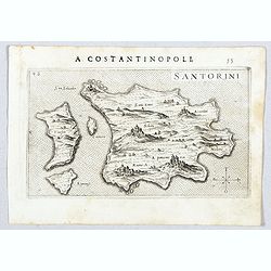
Santorini.
Very rare map of Santorini published in the first edition of "Viaggio da Venetia, a Costantinopoli. Per Mare, e per Terra, & infieme quello di Terra Santa. Da Gi...
Place & Date: Venice, Giacomo Franco, 1598
![Namphio. [Map of Anafi]](/uploads/cache/45243-250x250.jpg)
Namphio. [Map of Anafi]
Very rare map of the island of Anafi Island published in the first edition of "Viaggio da Venetia, a Costantinopoli. Per Mare, e per Terra, & infieme quello di T...
Place & Date: Venice, Giacomo Franco, 1598
![Stampalia. [Map of Astypalaia]](/uploads/cache/45244-250x250.jpg)
Stampalia. [Map of Astypalaia]
Very rare map of the Greek island Astypalaia. The island is known in Italian as Stampalia. Published in the first edition of "Viaggio da Venetia, a Costantinopoli. P...
Place & Date: Venice, Giacomo Franco, 1598
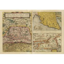
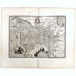
Carinthiae et Goritiae... / Histria tabula.../ Zarae, et Serebenici ..
Three maps on one sheet. The left hand is centered on the eastern part of Austria. The right upper hand map is centered on northern Yugoslavia, and the last map is center...
Place & Date: Antwerp, 1598
![Larii Lacus Vulgo Comensis Descriptio . . . [and] Terretorii Romani Descrip. [and] Fori Iulii Vulgo Frivli Typus. . .](/uploads/cache/41008-250x250.jpg)
Larii Lacus Vulgo Comensis Descriptio . . . [and] Terretorii Romani Descrip. [and] Fori Iulii Vulgo Frivli Typus. . .
Set of 3 maps of Lake Como, the region around Rome and the region around the Upper Adriatic, centered on Udinese from 'Theatrum Orbis Terrarum [Atlas of the Whole World]'...
Place & Date: Antwerp, 1598

Russiae, Moscoviae et Tartariae Descriptio.
Engraved by Frans Hogenberg from an original of 1562 by Anthony Jenkinson of the English Muscovy Company. The many vignettes are based on the reports of Marco Polo's expl...
Place & Date: Antwerp, 1598
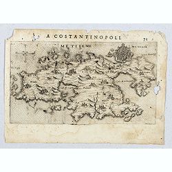
Metileme. (Lesbos)
Very rare map of Lesbos published in the first edition of "Viaggio da Venetia, a Costantinopoli. Per Mare, e per Terra, & infieme quello di Terra Santa. Da Giose...
Place & Date: Venice, Giacomo Franco, 1598
Scio. (Chios)
Very rare view of Chios Island published in the first edition of "Viaggio da Venetia, a Costantinopoli. Per Mare, e per Terra, & infieme quello di Terra Santa. D...
Place & Date: Venice, Giacomo Franco, 1598
![Le Roy de Navarra venant à Paris recheut le coup de cousteau au visaige par ung Pierre Chastel, lequel par quatre chevaulx fut tiré en pièces, faict le 27 de Decemb[re] l'an 1594.](/uploads/cache/38548-250x250.jpg)
Le Roy de Navarra venant à Paris recheut le coup de cousteau au visaige par ung Pierre Chastel, lequel par quatre chevaulx fut tiré en pièces, faict le 27 de Decemb[re] l'an 1594.
Engraved news-sheet with text in German and French. Pictorial reportage on the failed assassination attempt on King Henri IV of France by Jean Châtel (here identified as...
Place & Date: Cologne, ca. 1600
Il vero ritratto di Nettvno al presente oaupato da gl'imperiali.
Rare and early town-plan of Nettuno, in the province of Rome, which is nowadays a touristic harbor.Issued by Joannes Orlandi who acquired many Lafreri plates, which he re...
Place & Date: Rome, 1557 / 1602
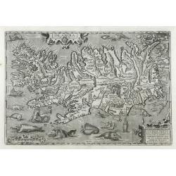
Islandia.
Perhaps the most famous map of Iceland. On the south side of the island a collection of all possible sea monsters is depicted. Polar bears on ice flows and volcanoes in t...
Place & Date: Antwerp, 1603
La marca d'Ancona. Marchia Anconitana Picaenum olim dicta. . . Romae apud Joannem Orlandini formis Rome 1604.
A re-issue of the plate by Vicentium Luchinù of 1564 now with the address of Orlandini and the dates 1602 / 1604.Collector's item. A unique opportunity to acquire a fine...
Place & Date: Rome, 1604
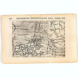
Inferior Germania.
A rare miniature map of present-day The Netherlands and Belgium. Strap-work title cartouche in the lower right corner with scale. Expertly engraved by Petrus Kaerius, the...
Place & Date: Amsterdam, 1606
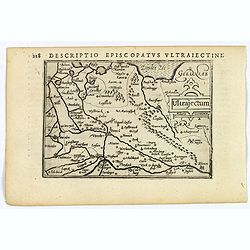
Ultrajectum.
An original early 17th century copper engraved miniature antique map of the Dutch province of Utrecht by Petrus Bertius, that was published in Amsterdam at the beginning ...
Place & Date: Amsterdam, 1606
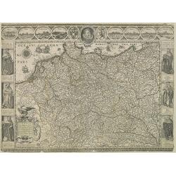
Germania.
Second state of this rare "carte à figures"- map of Germany, The Netherlands, Poland and central Europe. Bordered on three sides with portraits and views. In t...
Place & Date: Amsterdam, 1607
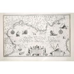
(Sea-chart of Catalunia, Languedoc, Provence, Cote d'Azur, Riviera, Corsica with Marseille, Cannes, Nice, Monaco.)
This very rare chart is important as the first printed sea chart of France's Mediterranean coast, also depicting Catalunya's northern coast, the Italian Cote d'Azur till ...
Place & Date: Amsterdam, 1607