Browse Listings in America > North America > North America
![Amerique Septentrionale divisée en ses principales parties. . .1685. [California as an Island]](/uploads/cache/60628-250x250.jpg)
Amerique Septentrionale divisée en ses principales parties. . .1685. [California as an Island]
Engraved by Cordier. Spectacular example of Jaillot's map of North America, showing California as an Island, based upon Sanson's landmark map of 1656. This map shows the ...
Place & Date: Paris, 1685
![Amerique Septentrionale divisée en ses principales parties. . .1692. [California as an Island]](/uploads/cache/27961-250x250.jpg)
Amerique Septentrionale divisée en ses principales parties. . .1692. [California as an Island]
A very good impression of Jaillot's large map of North America, showing California as an Island, based upon Sanson's landmark map of 1656. A first state.The map shows the...
Place & Date: Amsterdam, c.1692

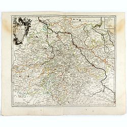
L'Amerique Septentrionale.
Very rare map, from "Metaphaste Barbao, Descriptio Indiae Occidentalis et America Nova" published by Henrico Verdussen.The map is a copy of Guillaume de L'Isle'...
Place & Date: Antwerp, 1702
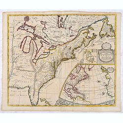
A new map of the English Empire in America. . .
This fine English map of eastern North America including Canada engraved by John Harris and first published by Robert Morden. John Senex acquired and made minor alteratio...
Place & Date: London, 1720
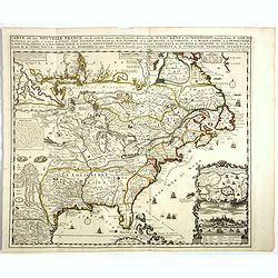
Carte de la Nouvelle France, ou se voit le cours des Grandes Rivieres de S. Laurens & de Mississipi..
Derived from de Fer's 1718 map, from west of the Mississippi it contains a mass of inland detail with notes and vignettes of the indigenous peoples and fauna of North Ame...
Place & Date: Amsterdam, 1720
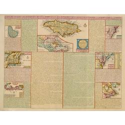
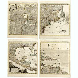
Carte qui contient..Iles & Terres..L'Amerique..Jamaique..
Eight maps on one sheet. From Chatelain's Atlas Historique et Méthodique . Including maps of Bermuda, Jamaica, New England with Long Island, Carolina, Chesapeake and Del...
Place & Date: Amsterdam 1728
A Map of the British Empire in AMERICA with the French, Spanish and Hollandish Settlements Adjacent Thereto. by Henry Popple. / Nouvelle Carte Particuliere de L'Amerique . . .
The four sheet Dutch edition of Popple's monumental map of North America, in mint condition. Encompassing the West Indies, Florida, Louisiana, Texas and Central America.T...
Place & Date: Amsterdam, ca. 1737

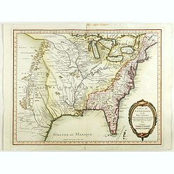
A new & accurate map of Louisiana, with part of Florida. . .
An English view of North America compiled from available French maps, especially those of Bellin used in Charlevoix's History of New France. English cartographers had lit...
Place & Date: London, 1744
Carte de LA LOUISIANE et des PAYS VOISINS Dédiée a M. Rouillé Dediee a M. Rouille Secretairr 'd Etat ayant le Departement de la Marine... 1750
North America from the eastern seaboard to the Rocky Mountains. Based on Delisle's map of 1718 with additions from notes compiled by the Jesuit priest, explorer and histo...
Place & Date: Paris, 1750
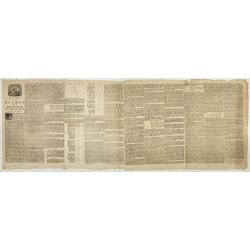
Nader prolongatie van het Octroy voor de Westindische Compagnie voor den tyd van nog dertig jaaren. . .
A proclamation by the Dutch States General, dated 1761, extending the charter of the Dutch West India Company for another thirty years. Like the 1730 proclamation, it has...
Place & Date: Amsterdam, 1761

America settentrionale. . .
Rare map of North America drawn directly from the work of Nicholas De Fer and N. Sanson's famous map of 1650. The map is engraved by Antonius Donzel Gallus.With open Grea...
Place & Date: Napels, 1766

United States of North America. Carte des Etats-Unis de l'Amerique Septentrionale / copiée et gravée sur celle d'Arrowsmith, corrigée et considérablement augmentée... par P. F. Tardieu...
FIRST EDITION. An impressive wall map here in 4 unjoined sheets and large margins. RARE in these untouched, full sheets. Recorded examples are usually offered as folding ...
Place & Date: Paris: An XI - 1802
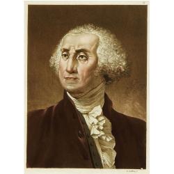
Portrait de George Washington.
Portrait of the first president of the united states of America.From Giulio Ferrario's work Le Costume ancien et moderne ou histoire du gouvernement, de la milice, de la ...
Place & Date: Milan 1827
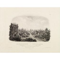
Forest scene on the Tobihanna Alleghany Mountains.
Original aquatint engraving for Travels in the Interior of North America between 1832-34 . Engraved by L.Weber. The finest work on American Indian life and the American F...
Place & Date: London/Paris/Coblenz, 1839
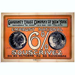
Guaranty Trust Company of New York. Emprunt national 6%.n Souscrivez.
Very decorative propaganda poster with design by Mark All of Paris for "Guaranty Trust Company of New York", a JPMorgan Chase predecessor in order to promote th...
Place & Date: Paris, 1918
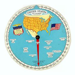
United States At-A-Glance.
A clever device for demonstrating the statistics of each state, the Area, Population, Highest Elevation, Principal River, Capital, railroad Mileage, Date Entered Union, P...
Place & Date: New York / London: International At-A-Glance Chart Co. 1931