Browse Listings in America > North America > California / Northwest Central
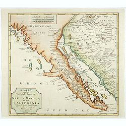
Kaart van het Westelyk Gedeelte van Nieuw Mexico en van California. . . MDCCLXV ..
A detailed map of the Baja California and Sonora, bounded on the north by the Colorado and Gila Rivers and approximately Mozatlan in the south, thus including parts of mo...
$795 / ≈ €700
Place & Date: Amsterdam, 1765
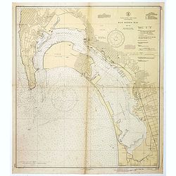
San Diego Bay. (Chart 5107)
Nautical chart of San Diego Bay of 1945. Printed in black, yellow and purple the "Seaward limit defensive sea area". The water area within the indicated limits ...
$500 / ≈ €440
Place & Date: Washington, 1945
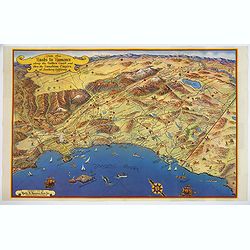
Ride the Roads to Romance along the Golden Coast and thru the Sunshine Empire of Southern California.
This striking touring map of Southern California was published in 1950 by the Roads to Romance Association in order to promote tourism to Southern California. It provides...
$150 / ≈ €132
Place & Date: California, 1950