Browse Listings in America > Caribbean & Atlantic Ocean > Caribbean general
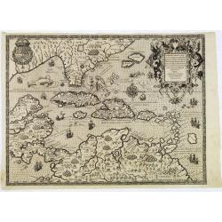
Occidentalis Americae partis.
The most beautifully engraved early map of the Caribbean, including Florida and the Southeast. The map includes representations of Columbus' ships and various notes regar...
Place & Date: Frankfurt, 1594
![Pisces in mari alati [flying fish attack]](/uploads/cache/48527-250x250.jpg)
Pisces in mari alati [flying fish attack]
Flying fish attacking a Portuguese ship in the West Indian Waters.Read more about "Les Grand Voyages" by Theodore De Bry [+]
Place & Date: Frankfurt, 1594
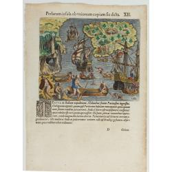
(Island of Pearls) Perlarum insula ob unionum copiam sic dicta.
A depiction of Cubagua as the Perlarum Insula (Island of Pearls), with in the foreground, two large ships send dinghies toward busy Native Americans collecting pearl oyst...
Place & Date: Frankfurt, 1594
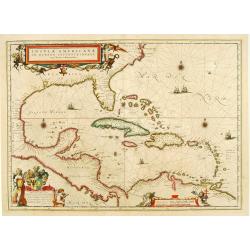
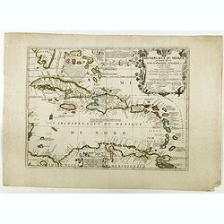
Insulae Americanae in Oceanus Septentrionali cum Terris..
General map of the West Indies extending from Virginia to the mouth of the Orinoco, and destined to be copied in various shapes by many other publishers. Title cartouche ...
Place & Date: Amsterdam, 1647
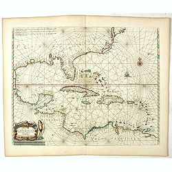
Pascaerte vande Caribische Eylanden, vande Barbados tot aende Bocht van Mexico ‘t Amsterdam By Hendrick Doncker. . .
First state. Rare. “This chart appeared in the first edition of Hendrick Doncker’s Zee-Atlas, of which no surviving example is known” -- Burden. This is an example ...
Place & Date: Amsterdam, 1659
Archipelague du Mexique ou sont les Isles de Cuba..
Scarce map of Caribbean. A visually stunning map with a large title cartouche. This large one-sheet map was produced by the Venetian cosmographer Vincenzo Coronelli when ...
Place & Date: Paris, 1688
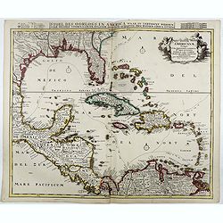
Stoel des Oorlogs in America Waar in Vertoont Werden Alle Desself Voornaamste Eylande . . .
Large impressive map of the West Indies with the Gulf of Mexico and Florida. The map shows prominently in the center Cuba, Haiti, the Bahamas and Florida, which is here m...
Place & Date: Amsterdam, c. 1720
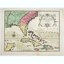
Carolinae Floridae nec non Insularum Bahamensium cum partibus adjacentibus delinatio ad Exemplar Londinense in lucem edita . . . Ao. 1755.
The German edition of this map of Carolina, Florida, and the Bahama Islands in full original colors. Published in Seligmann's "Sammlung verschiedener auslaendischer ...
Place & Date: Nuremberg, 1755
Carte Geo-Hydrographique du Golfe du Mexique et de ses Isles..
Map of the Caribbean and Gulf of Mexico showing the various islands and continental coastlines according to the 18th century Venetian cartography of Rizzi Zannoni.Illustr...
Place & Date: Paris, ca 1783
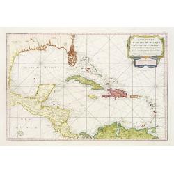
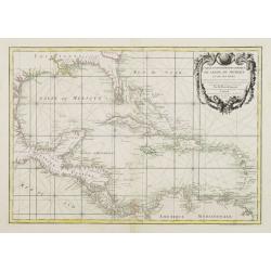
Carte Réduite Du Golphe Du Mexique Et Des Isles De L' Amérique..
A well engraved and highly detailed chart prepared by Bellin of the Gulf of Mexico and the Caribbean. In addition to a magnificent title cartouche and a color key to the ...
Place & Date: Paris dated year 17, or 1808
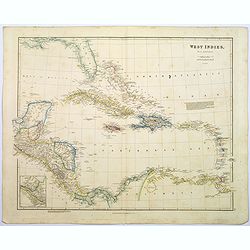
West Indies.
A fine, detailed steel engraved map comprising Florida, Bahamas, Cuba, Haiti, Jamaica, the Windward, and the Leeward Islands, the northern Columbian coastline, Panama, Gu...
Place & Date: London, 1839
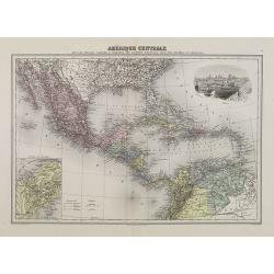
Amérique Centrale.
Decorative map of Central America from Géographie Universelle, Atlas Migeon. With an inset map of the Isthmus of Panama lower left corner and a panoramic view of Mexico ...
Place & Date: Paris, 1874