Browse Listings in America > Caribbean & Atlantic Ocean > Bermuda / Bahamas
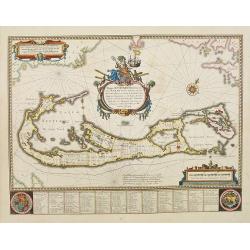
Mappa Aestivarum Insularum alias Barmudas.
Blaeu based his work on John Speed's remarkably accurate map of 1626-1627. It shows the island divided into tribes and lots, and below the map itself appear the names of ...
$2200 / ≈ €2018
Place & Date: Amsterdam, 1635
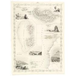
Islands in the Atlantic.
Decorative steel engraved map of Islands showing the Azores, Madeira, Bermuda, the Canaries and the Cape Verdes. Interlocking border design. Taken from "The illustra...
$150 / ≈ €138
Place & Date: London, ca. 1851