Wish List
With WishList / Virtual Collection, you can save and collect your favorite items in one place, it is free and you can delete an item from your list at any time.
Save any of the 30.000+ maps, prints or Medieval manuscripts from our BuyNow Catalog or Catalog Archive.
Unless logged in, an item is only saved for that session. If you want to save the items permanently, please log in first.
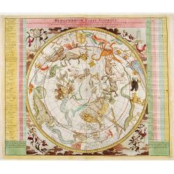
Hemisphaerium Coeli Australe.
Magnificent celestial chart drawn by the famous scientist Johann Gabriel Doppelmayer. Large circular charts of the southern hemisphere constellation, with decorative vign...
Place & Date: Nuremberg 1720
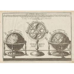
La Sphere Artificielle, ...
Decorative engraving showing an armillary sphere surrounded by a celestial and a terrestrial globes, from De Fer's Atlas Curieux.
Place & Date: Paris, 1717
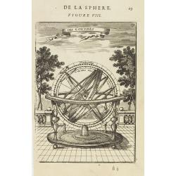
Des Colures.
Appealing print focused on an armillary sphere showing the equinoctial and the solstitial colures.From the French text edition of Description d''Univers.. (5 volumes), 16...
Place & Date: Paris, 1683
![[ LXXII. Divertimenti de' serpenti ].](/uploads/cache/34981-250x250.jpg)
[ LXXII. Divertimenti de' serpenti ].
Aquatint depicting snake charmers engraved by D.Klemi-Bonatti, Plate N°60.From Giulio Ferrario's work Le Costume Ancien et Moderne ou Histoire du gouvernement, de la mil...
- $50 / ≈ €44
Place & Date: Milan, 1827
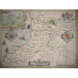
Cardigan Shyre Described With The Due Forme Of The Shyretown as it was surveyed by J.S. Anno 1610.
By John Speed First edition 1611. An early map of this Welsh coastal county. From John Speed’s atlas ‘The Theatre of the Empire of Great Britaine’. Published in Lon...
Place & Date: London, 1611-1612
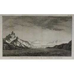
Baye de la Posession dans l'Isle de la Géorgie Australe.
From the French edition of James Cook's second voyage entitled Voyage dans l'Hémisphère Austral, et autour du Monde, fait sur les Vaissseaux de Roi, l'Aventure, la Rés...
Place & Date: Paris, 1778

Carte d'une partie de la terre de Witt (à la nouvelle Hollande) 1ère feuille.
Map of the Western Australian coastline from Point Murat to Cape Keraudren showing tracks of "Le Geographe" in 1801 and "Le Casuarina" in 1803. Relief...
Place & Date: Paris, 1801

Orchis latifolia. / Cynosorchis faemina. / Nidus levis/ Dentaria radice coral loide.
Beautiful Orchis latifolia. Beautiful Circea and Lily from the first edition of the Hortus Eystettensis, printed and issued by Basilius Besler in Nuremberg 1613. This yea...
Place & Date: Nuremberg, 1613
![[Lot of 3 maps] Uplandia, plus a map of the island of Ruegen by W, Blaeu and the General map of Scandinavia by Reinier & Joshua Ottens.](/uploads/cache/82017-250x250.jpg)
[Lot of 3 maps] Uplandia, plus a map of the island of Ruegen by W, Blaeu and the General map of Scandinavia by Reinier & Joshua Ottens.
An attractive map of Upland with Stockholm. With two nice cartouches. Moses Pitt (d.London,1696), planned to publish together with Janssonius' son-in-law, Janssonius van ...
Place & Date: London, 1680
Selling price: $220
Sold in 2022
America Septentrionalis.
This rare, tiny map features a large island of California of the Briggs type with a flat northern coast. Terra de Iesso is depicted across a narrow F. Anian to the west o...
Place & Date: Ulm, 1702
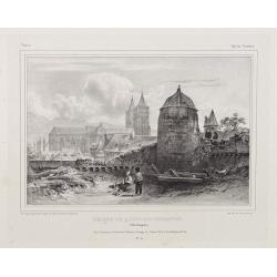
Eglise de Quimper-Corantin. (Bretagne).
A city view of Quimper in Bretagne and its church. Made "after nature" by Serda in 1837.
Place & Date: Paris, ca. 1840

(5 Plates depicting art of gilding) Doreur.
Four copper engravings showing the art of gilding by Prevost. The etchings, with engraving and stipple, on cream laid paper Excerpted from Diderot's "Encyclopede du ...
Place & Date: Paris, 1751
![[No title] - In inset: Habes hic Novam & Accuratissimam Descriptionem Tractus Illius Flandriae...](/uploads/cache/31583-250x250.jpg)
[No title] - In inset: Habes hic Novam & Accuratissimam Descriptionem Tractus Illius Flandriae...
Rare map of Noord-West Vlaanderen, engraved by Petrus Kaerius in 1605. The cartouche at top right-hand corner testifies to acts of war from 1600 to 1605.From: Petri Kaeri...
Place & Date: Amsterdam, 1617
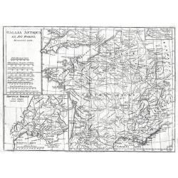
Gallia Antiqua Ex Aevi Romani.
Gallia Antiqua Ex Aevi Romani 1795 by Samuel John Neele Published May 10th 1795 by Cadell & Davies of the Strand London.18th century map of Ancient France. Inset of t...
Place & Date: London, 1795
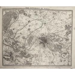
S.D.U.K map ENVIRONS OF PARIS
Finely engraved plan of the city and surrounding countryside. One of the most detailed early 19th century plans. The map extends to Montmorency in the north, Champigny in...
Place & Date: London, 1832
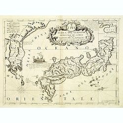
Isola del Giapone e Penisola di Corea. . .
A most attractive and decorative map of Japan and its near neighbor Korea by Vincenzo Coronelli. An elaborate central title cartouche garlanded with intertwined flowers a...
Place & Date: Venice, 1698
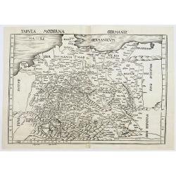
Tabula Moderna Germanie.
Woodblock map of Ptolemaic Central Europe from Denmark to the Alps and from France to Poland.Title along top. No text on verso. Rare map from the first modern atlas by Ma...
Place & Date: Strasburg, Johann Schott , 1513-1520
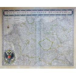
Nova Totius Germaniae Descriptio.
Highly detailed and finely engraved map of Germany, Poland, Netherlands, Belgium, Austria and a little part of Italy and Croatia.The title cartouche runs along the upper...
Place & Date: Amsterdam, 1647
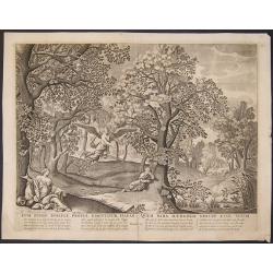
Cum Puero Ismaele procul dimittitur Hagar, quem Sara Haeredem noluit esse suum.
Biblical scene of the New Testament, Genesis 21, with beautiful and decorative view and staffage.
Place & Date: Amsterdam, 1730
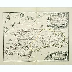
L'Isle St. Domingue ou Espagnole. . .
RARE and striking Saint-Domingue map, discovered by Christopher Columbus in 1492. Shows the eastern tip of Cuba and the Turks and Caicos Islands.The map shows the major S...
Place & Date: Paris, Danet, 1723
![AER.. / TERRA.. / AQUA.. / IGNIS FERRI FUSOR.. [4 elements]](/uploads/cache/15965-250x250.jpg)
AER.. / TERRA.. / AQUA.. / IGNIS FERRI FUSOR.. [4 elements]
Decorative matching set of four prints depicting water, earth, water and fire. Design by C.Le Brun and published by P. van de Berge, who was a publisher active in Amsterd...
Place & Date: Amsterdam 1700
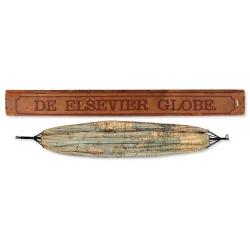
Collapsible, umbrella globe.
Naar de nieuwste bronnen bewerkt onder toezicht van G.J. Dozy. Gratis-premie op het boek der reizen en ontdekkingen. Rott., Elsevier, (1881). Collapsible, umbrella type g...
Place & Date: Rotterdam, 1881
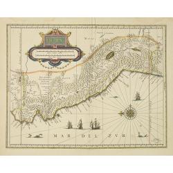
Peru.
Decorated with ships and monsters in the sea. Orientated with east at the top. With the signature of G. Blaeuw lower right corner. Shows the Pacific coast of South Americ...
Place & Date: Amsterdam, 1638

Marchionatus Sacri Romani Imperii.
Beautiful and decorative "carte à figures"- plan of the city of Antwerp with its surroundings. Three panoramic city views of Antwerp and ten vignette views of ...
Place & Date: Amsterdam, 1678

Clivia Ducatus et Ravestein Dominium.
A very decorative map with broad margins, showing a.o. the towns of Nijmegen, Venlo, Moers and Emmerich.
Place & Date: Amsterdam, 1647
![Dépt. De La Manche. N°49. [ Cherbourg ]](/uploads/cache/27128-250x250.jpg)
Dépt. De La Manche. N°49. [ Cherbourg ]
Map of the coastal region of the Normandy, including Cherbourg.Lovely map from one of the last decorative atlases of the nineteenth century.The rather simple map is frame...
Place & Date: Paris, A. Combette, 1852
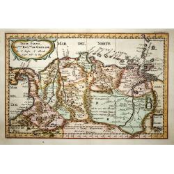
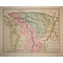
Terre Ferme Nouveau Royme de Grenade, &c.
Very attractive small map of the northern part of South America, including most of modern Panama. Regional boundaries are shown along with missions, towns, major rivers a...
Place & Date: Amsterdam, 1700
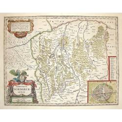
Territorium Norimbergense.
Map displays area of Germany centered on Nuremberg. Nice decorative cartouche with an inset of Nuremberg in the lower right corner.
Place & Date: Amsterdam, 1635

Monument consacré a la posterité. . . / Ter eeuwiger gedagtenisse. . .
Decorative print. Monument consecrated to posterity in memory of the unbelievable folly of the 20th year of the 18th century. Decorative !A caricature in prose and verse ...
Place & Date: Amsterdam, 1720
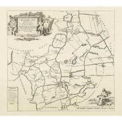
Idaardera deel de tiende Grietenije van Ooster Goo. . .
Very detailed map of "Idaardera deel de tiende Grietenije van Ooster Goo" in Friesland prepared by Bernardus Schotanus Steringa. Centered on Grouw. With decorat...
Place & Date: Leeuwarden, 1718
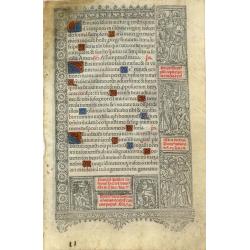
Leaf on vellum from a printed Book of Hours.
Book of Hours leaf, printed by Thielman Kerver* in 1507. It is printed on vellum in black and red with many initials hand-painted in red, blue, and gold.Around the text a...
Place & Date: Paris ca. 1507
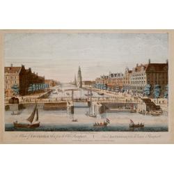
A View of Amsterdam taken from the Old Rampart / Vüe d'Amsterdam prise du Vieux Rampart.
A view of Amsterdam published by Robert Laurie & James Whittle. Inscription below, "Publish'd according to Act of Parliament. Published 12th May, 1794 by Laurie ...
Place & Date: London, 1794
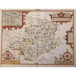
Montgomeryshire. (1612, 1st edition)
Wales, a beautiful county map of Montgomeryshire by John Speed. Published in Speed’s "Theatre of the Empire of Great Britaine" in 1612 the 1st edition publish...
Place & Date: London, 1612
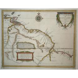
Guaiana ofte de Provincien tusschen Rio de las Amazonas ende Rio
Hessel Gerritsz was apprenticed to Blaeu as an engraver before starting his own business. He then was appointed Cartographer to the Dutch East India Company and subsequen...
Place & Date: Amsterdam, 1630
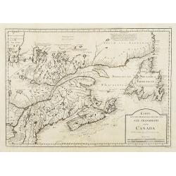
Karte von dem Ostlichen-Stucke von Neu Frankreich oder Canada..
The German edition after Bellin's map that served as the basis for numerous maps to follow. Includes eastern Canada and Newfoundland including Nova Scotia (Arcadia) and P...
Place & Date: Leipzig, Arkstee & Merkus, 1746
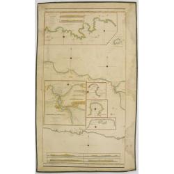
Gemah-, Segoro-Wedie-, & Soembreng Baaijen,. . . .
Large detailed blue-back chart of a part of Java, dated 1849, showing the results of local surveys in the period 1835-1849.No publisher mentioned (probably the Dutch Geog...
Place & Date: Jakarta, 1849
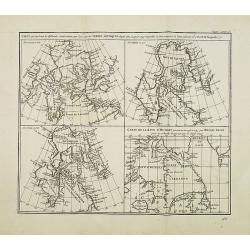
Carte qui représente les différentes connaissances ... des Terres Arctiques depuis 1650 jusqu'en 1747 . . .
Four maps on one sheet, all covering the northeastern part of America and Greenland, including the Hudson, Button and Baffin Bay regions, the Davis Straits and the Coast ...
Place & Date: Paris, 1773
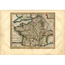
Galliae Veteris Typus.
Attractive small map of France based on Ortelius and classical geographical sources. Small strapwork title cartouche. Engraved by Petrus Kaerius.
Place & Date: Amsterdam, 1661
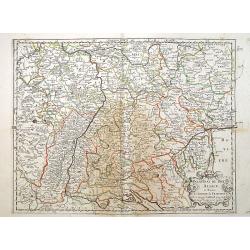
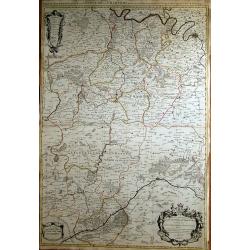
Palatinat du Rhein Alsace Souabe de Franconie..
"Covering southern part of the river Rhine and start of the Danube. Including the towns of Frankfurt, Ingolstadt, Basle, Spier, Trier, etc.Engraved by R.Cordier Abba...
Place & Date: Paris 1648
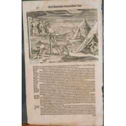
Grand Voyages
This is an illustrated page from The Grand voyages (1598-1617), by Theodore De Bry. It references the Indians.
Place & Date: Frankfurt, 1598 - 1617
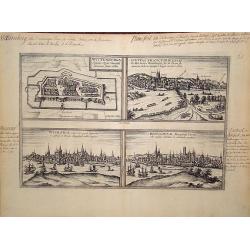
Wittenburga. Wismaria. Civitas Francfordiensis. Rostochium.
Early views of Wittenberg, Wismar, Francfort and Rostock, a bird''s eye view from the greatest publication in this genre ! The Civitates was compiled and written by Georg...
Place & Date: Cologne, c.1580
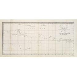
Cartes des Isles découvertes aux environs d'Otahiti . . .par les Capitaines Byron, Wallis, Carteret et Cook en 1765, 1767, 1769. Tome III Pl. 3.
Map French Polynesia with the tracks around the island of Tahiti by Captain Byron, Wallis, Carteret and Cook in 1765, 1767 and 1769. This map is taken from the first Fre...
Place & Date: Paris, 1774
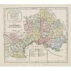
Languedoc, Dauphiné, Provence.
Map of Languedoc, Dauphiné, Provence. By C. F. Delamarche, successor of Robert de Vaugondy, Geographer. Inset lower center margin of the 14 departments of this region.
Place & Date: Paris, 1794 - 1806
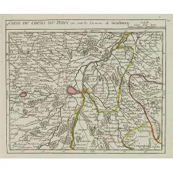
V. Carte du Cours du Rhin où sont les Environs de Strasbourg.
Small detailed map illustrating the stretch of the Rhine which flows beside Strasbourg.From Atlas Portatif Universel, by Robert de Vaugondy.Unrecorded state with erased d...
Place & Date: Paris, later than 1749

Coeffure formée de velours . . .
From Costume Parisien (1797-1839).Paris was the capital for fashion innovation and design. After the final defeat of Napoleon, English and French fashions merged to close...
Place & Date: Paris, 1824
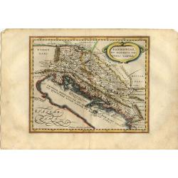
Pannoniae, et Illyrici Veteris Tabula.
Attractive historical map of the Dalmatian coast from Italy to Greece. The map is based on Ortelius' map of the same title, which was based on Gastaldi's map of South Eas...
Place & Date: Amsterdam, 1661
Royaume de Congo.
Attractive map of Gabon, the Congo and Angola from Cape Lopez and Sao Tomé to approximately the border with present-day Namibia. The map is fully engraved with mountains...
Place & Date: Amsterdam, 1700
![[Title page of the Atlas in Russian]](/uploads/cache/25602-250x250.jpg)
[Title page of the Atlas in Russian]
A more than 100 year old title page printed in lithography. Published by one of the most successful publishers of St. Petersburg A.Iljin.
Place & Date: St. Petersburg, c.1905
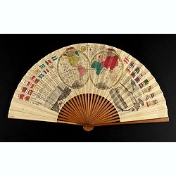
A folding fan with a map of Japan, double hemisphere world map and views of Yokohama and Edo.
The folding fan showing a map of Japan on one side, and on the other side a double hemisphere world map, two city views, and a train. Read more about folding fans andcar...
- $750 / ≈ €661
Place & Date: Japan, ca. 1880
Partie meridionale de L'Evesché de Chartres...
Very fine map of Chartres, prepared by Nicolas Sanson and published by Hubert Jaillot.
Place & Date: Paris, c.1692
Plan géométrique des environs de Nice, de Monaco, et de Menton.
Folding-map of the Nice, Monaco and Menton viccinities. A traveler's guide. On the upper left a cartouche stating different observations. Engraved by Erhard, geographer a...
Place & Date: Paris, 1870
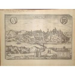
Misena.
Early view of Meissen, a bird''s eye view from the greatest publication in this genre ! The Civitates was compiled and written by George Braun, Canon of Cologne Cathedral...
Place & Date: Cologne, c.1580
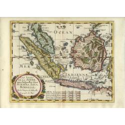
Les Isles de la Sonde, entre lesquelles sont Sumatra, Iava, Borneo, &c.
Beautiful and uncommon map of Indonesia showing the Malay Peninsula, Sumatra, Java and Borneo. The islands are very detailed and have many place names noted, including Si...
Place & Date: Amsterdam, 1700
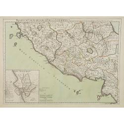
Regionum Italiae mediarum Tabula Geographica..
Fine historical map of central Italy with Tuscany and centered on Rome, in the south Pompeii, in top the island of Giglio and the town Orbetello. Lower left inset plan of...
Place & Date: Paris, 1707
Selling price: $55
Sold in 2022
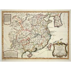
Das Kaiserthum China..
Attractive and detailed map of China and Korea. The Sea of Japan is labeled \"Das meer von Korea\". The composition is nicely balanced with three decorative car...
Place & Date: Leipzig, Merkur, 1748

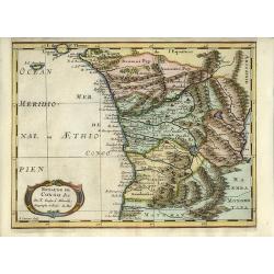
Portvgallia et Algarbia quae osim Lvsitania
Map of Southern Portugal. Off the coast three vessels and Zeus ridding a sea monster are shown. In the bottom a centre a richly decorated cartouche is placed. The map sho...
Place & Date: Frankfurt, 1635
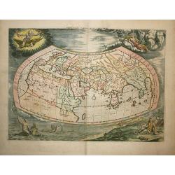
Universalis Tabula Iuxta Ptolemaeum
This decorative map of the ancient world is the revised second state of Mercator's1578 Ptolemaic world map. The border was re-engraved, surrounded by allegorical figures ...
Place & Date: Amsterdam, 1730
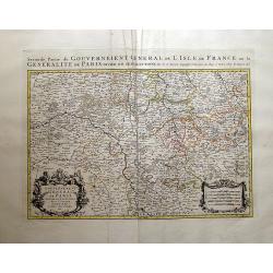
Gouvernement et Generalité de Paris?
Very fine map of Paris, prepared by Nicolas Sanson and published by Hubert Jaillot.
Place & Date: Paris, 1692

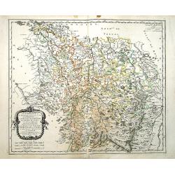
Geographica descriptio Montani cujusdam districtus in ..
Detailed map including the towns of Thurnau, Bayreuth, Culmbach, etc. With fine panoramic view of Thurnau. Upper left and right splendid title cartouches.The map is paint...
Place & Date: Nurenberg, 1710

A Chinese official with a ceremonial hat, holding a fan and a silk purse.
A colored wood block print of a Chinese official with a ceremonial hat, holding a fan and a silk purse.
Place & Date: Nagasaki, c. 1830
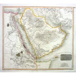
Arabia, Egypt, Abyssinia, Red Sea &c.
Thomsons superbly copper-engraved map of the Arabian Peninsula including what is today Egypt, Saudi Arabia, parts of Iran and Iraq, Yemen, Oman, the United Arab Emirates,...
Place & Date: Edinburgh, 1814
La Lorraine et les Estats qui passent..
"Fine map of the area Lorraine, engraved by R. Cordier d'Abbauil. The cartouche presents the address of Pierre Mariette; rue St.Jacques a L'Esperance"". Ni...
Place & Date: Paris 1661
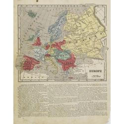
Europe.
Map of Europe. From Sidney E. Morse''s: System of Geography for the use of schools , published by Harper and brothers, 329 Pearl Street, New York.An 150 years old map wit...
Place & Date: New York, 1855
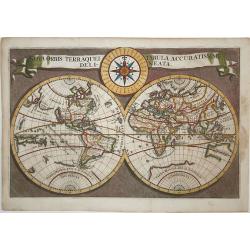
Nova Orbis Terraquei Tabula Accuratissime Delineata.
A very scarce, small map of the world cartographically similar to Danckerts map of 1685, with a coastline to the large Terra Magellanica Australis on the South Pole. Cali...
Place & Date: ca. 1700
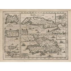
Cuba Insula. Hispaniola.
Decorative engraved map of Cuba above Hispaniola with smaller insets of Havana, Jamaica, Puerto Rico and Margarita. Italian text verso with page number284 and title: Teat...
Place & Date: Amsterdam, Clement de Jonge, 1690
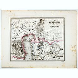
Il Turkestan il Mar d'Aral ed il Mar Caspio.
Uncommon map of Turkestan with the Northern part of the Caspian Sea, prepared by Francesco Costantino Marmocchi. Above the map "Geografia Commerciale". From &qu...
Place & Date: Genova, Paolo Rivara fu Giacomo, 1858
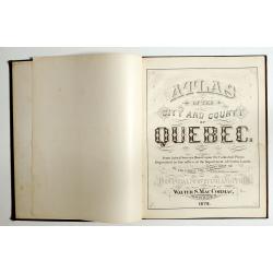
Atlas of the city and county of Quebec from actual surveys, based upon the cadastral plans deposited in the office of the Department of Crown Lands.
This scarce city atlas of Quebec is illustrated with 18 hand-colored maps made by Henry Whitmer, 1838-1920. The atlas contains 12 maps of Parishes, 5 maps of Quebec by ...
Place & Date: Provincial Surveying and Pub. Co., Walter, S, MacCormac, manager,1879
Selling price: $850
Sold in 2023
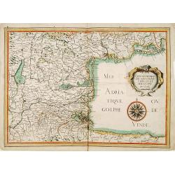
Carte des duchez de Mantoue, Ferrare.. Venise.
Detailed map of the north/east part of Italy, showing Mantoue, Verona, Venice, Padoua, Ferrare, Bologne, Ravenna, etc. Beautiful wind-rose. The title cartouche in the for...
Place & Date: Paris, 1634
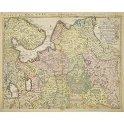
Carte de Moscovie dresseé par G.De L'Isle..
Centered on Moscow, including Lapland. With fine uncolored title cartouche.
Place & Date: Amsterdam, 1720
Nieuwe kaart van Suriname..
Decorative full color example of Ottens map of Surinam. Detailed map of the northeast part of Surinam between Paramaribo and Mana. Nice wide margined example. Blank verso...
Place & Date: Amsterdam, ca. 1740
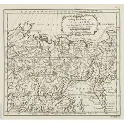
Verfolg der Karte von Siberien und des Landes Kamtschatska. . . N°5.
Map of Siberia including Kamchatka. In: Allgemeine Historie der Reisen zur Wasser und zu Lande: oder Sammlung aller Reisebeschreibungen.. in Englischen zusammen getragen,...
Place & Date: Leipzig, 1753

The Soviet Political Poster.
An attractive Soviet Union political poster. The poster was part of a set of reproductions from posters initially published from 1919 to the 1970s. Published in Leningrad...
Place & Date: Leningrad, Aurora Art Publishers, 1976

Carte des Diocèses de Québec Trois-Rivières Montréal.
Separately published map of the diocese of Quebec and Montreal, printed in Rome. Showing the situation in the year 1882. Trois-Rivières is a city in the Mauricie region ...
Place & Date: Rome, 1884
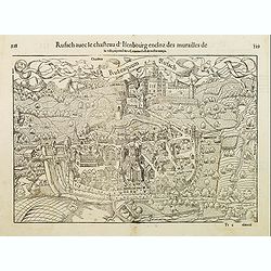
Rufach avec le chasteau d'Isenbourg encloz des murailles de la ville. . .
The town of Rufach in Alsace. With French text on verso.
Place & Date: Basle, ca. 1560

View of Endeavour River, on the coast of New Holland, where Captain Cook had the Ship laid on Shore, in order to repair the Damage which she received on the Rock.
One of only a handful of 18th century images of the ship Endeavour.This copperplate view shows Cook's ship leaning on an angle, while repairs are hastily carried out - so...
Place & Date: London, 1784
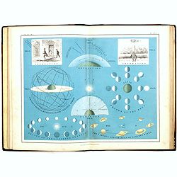
School atlas of astronomy: Comprising, in eighteen plates, a complete series of illustrations of the heavenly bodies. . .
An early edition of this fine Victorian celestial school atlas by Alexander Keith Johnston and edited by J.R. Hind. Illustrated with 18 decorative lithograph colored plat...
Place & Date: Edinburg, London, Blackwood and sons, 1855

Namurcum comitatus.
Very rare map of the province Namen by Cornelis Danckerts. Depicting the region around the city of Namen/Namur based on the once-secret map of Jacques Surhon (ca. 1555). ...
Place & Date: Amsterdam / Paris, ca. 1640
Selling price: $250
Sold in 2022

Ierusalem
Impressive very large panoramic view of the city of Jerusalem, based on the work of Wenceslas Hollar, shows a panorama of ancient Jerusalem as viewed from the east. The m...
Place & Date: Amsterdam, 1677
Selling price: $650
Sold in 2022

Une spectatrice - Le Café Concert.
Original lithograph of a spectator by Henri de Toulouse-Lautrec, from the Le Café-Concert series. Printed on the hand press by Edouard Avcourt.This original lithography...
Place & Date: Paris, 1893

Le Royaume de Sardaigne...
Santini's superb map of Sardinia. Highly detailed with major roads, towns, rivers, lakes, etc. Symbols indicate natural resources and mines such as gold, silver, iron,......
Place & Date: Venice, 1779