Wish List
With WishList / Virtual Collection, you can save and collect your favorite items in one place, it is free and you can delete an item from your list at any time.
Save any of the 30.000+ maps, prints or Medieval manuscripts from our BuyNow Catalog or Catalog Archive.
Unless logged in, an item is only saved for that session. If you want to save the items permanently, please log in first.

Chinese painting on silk.
Fine oriental miniature of a Chinese couple engaged in amorous pursuit. Quin Dynasty, late 19th. century.This type of Chinese painting, usually anonymous, also called &qu...
Place & Date: China, ca. 1880
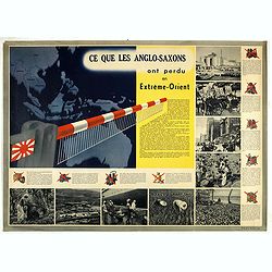
Ce que les Anglo-Saxons ont perdu en Extrême-Orient.
Illustrated Vichy propaganda War & Propaganda poster showing a map of South East Asia, with Indonesia, Philippines, Thailand, etc., among photos and explanations abou...
Place & Date: Paris, 1943
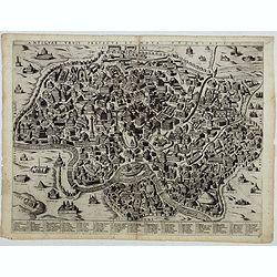
Antiquae urbis perfecta et Nova delineatio. [ Ancient Rome)
First state before imprint of Jacobus de Rubeis. A rare view of Ancient Rome from the Lafreri-School in the style of Ambrogio Brambilla's view of about 1575. A unique opp...
Place & Date: Rome, ca. 1600
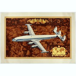
AIR France - Super constellation, Lockhead L - 10 - 49.
Promotional poster attributed to Lucien Boucher showing of a Lockhead L - 10 - 49 on a Mercator projection world map. The map depicts a pictorial map of the entire world ...
Place & Date: Perceval, Paris, 1953
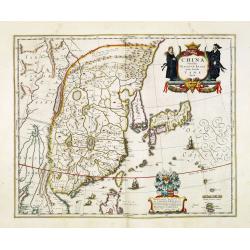
China Veteribus Sinarum Regio.
This was the first of Blaeu's maps of China. In 1655 he was to publish the famous map of Father Martini, with many of the earlier inaccuracies present on this map correct...
Place & Date: Amsterdam, 1653
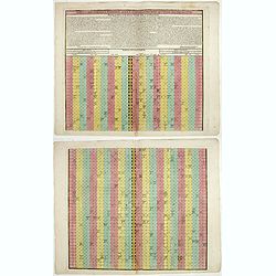
Tabula chronologica historiae Sinicae connexa cum cyclo qui vulgo Kia Tse dictur.
A set of two sheets of colored copper engravings. First published in 1729 in Rome in three sheets. Timeline of China's history with a chronological overview of the dynast...
- $1200 / ≈ €1057
Place & Date: Augsburg, 1746

Partie de Lithuanie ou sont en partie les Palatinats de Minsk, et Mseislaw, we les Seign.Ries ou Terres de Rohaczow, Rzeczica, Zernobee, et partie des. . .
Fine map of Lithuania. This edition carries the publishers address "chez l'Autheur Avec privilege pour vingt ans 1666". Nicolas Sanson was to bring about the ri...
Place & Date: Paris, 1666
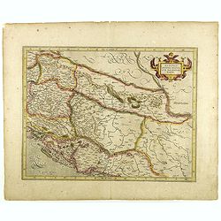
Sclavonia, Croatia, Bosnia cum Dalmatiae parte.
Nice map of the Eastern Balkans with the geographical & political divisions of Dalmatia, Croatia, Slavonia, Bosnia, Serbia, etc.Mercator was born in Rupelmonde in Fla...
- $250 / ≈ €220
Place & Date: Amsterdam, 1632

Circoscrizione delle Province ecclesiastiche e Diocesi nelle Impero di Russia in Europa vicariato aplico di Svezia Norvegia e prefettura del Polo Artico (Tav XC)
A large-format map of Sweden, Norway, Russia with its different dioceses. Inset map of Iceland and a North Pole projection. The map is finely engraved and beautifully col...
- $550 / ≈ €485
Place & Date: Rome, 1858
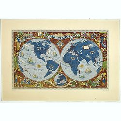
AIR France - Sur les ailes d'Air France découvrez le monde à votre tour.
Promotional poster of a double hemisphere world map designed by Lucien Boucher for AIR France. The map depicts the entire world in rich blues and burgundies with gold hig...
- $750 / ≈ €661
Place & Date: Perceval, Paris, 1952
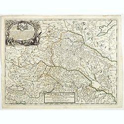
Parte della Schiavonia, overo Slavonia, aggiuntavi la contea di Cilles e Windisch mark abitate da populi slavini, ò slavi. . .
The map of Slavonia by Cantelli from his atlas “Mercurio Geografico” issued in Rome in 1690 by the publisher and printer Giacomo Rossi. The map shows parts of the med...
- $400 / ≈ €352
Place & Date: Rome, 1690

(Die Fontanka beim kaiserlichen Garten in Petersbourg.)
Fontanka River at the Summer Garden in Saint Petersburg. Part of a set of 14 loose and individually mounted plates of views of St. Petersburg and Moscow, plus one plate o...
- $100 / ≈ €88
Place & Date: St. Peterdburg, 1806
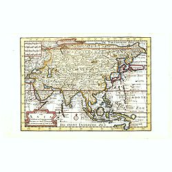
Kaartje van Asia. . .
Attractive and rare map of Asia. From Atlas Portatif . With a curious and oversized Hokkaido. The map is of interest for the use of Coreanse Zee for the sea between Korea...
Place & Date: Deventer 1742
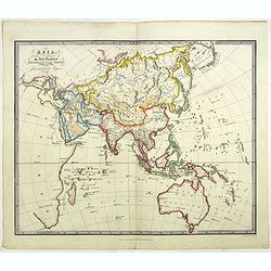
Asia for the Elucification of the Abbe Gaultier's Geographical Games.
An unusual Children's educational map of Asia, Countries depicted in different colors, and with only some physical features engraved, like mountain ranges and rivers, som...
Place & Date: London, 1823
Selling price: $350
Sold in 2024
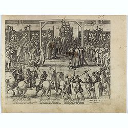
The hanging of the head of police Jean Grauwels in Brussels, 11 february 1569.
Print relating to Brussels during the first decades of the eighty year war between Spain and the Low Countries: (plate 18). This plate shows the hanging of the head of po...
Place & Date: Cologne, ca. 1590
![[Text page]. La tierce aage. Feuillet IXxxII.](/uploads/cache/42004-250x250.jpg)
[Text page]. La tierce aage. Feuillet IXxxII.
Incunable text pages from "La Mer des Hystoires" published in 1488 by Pierre Le Rouge in Paris. "La Mer des Hystoires" is a translation into French of...
Place & Date: Paris, Pierre Le rouge, 1488
Selling price: $30
Sold in 2022
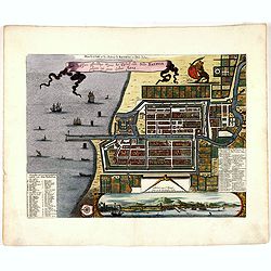
Plan de la Ville et du Chateau de Batavia en l'Isle de Iava / Ware affbeeldinge wegens het Casteel ende Stadt Batavia gelegen opt groot Eylant Java.
Detailed East-oriented plan of Jakarta former Batavia on Java / Indonesia. With a bird's eye view from seaside, various ships and a lion. Two inset keys with detailed des...
- $750 / ≈ €661
Place & Date: Leiden, 1730

VOLGA RIVER. -Accurata delineatio Nobilissmi toti Europae Fluminis Wolgae olim RHA dictae per Adamum Olearium.
Rare First Edition of The First Great Map of the Volga River. Nice example of Olearius' map of the Volga River, first issued in 1647 and engraved by Christian Rothgiesser...
Place & Date: Schleswig, 1647
Selling price: $1300
Sold in 2021
![Air France [poster].](/uploads/cache/44696-250x250.jpg)
Air France [poster].
A superb double sided Air France folding poster, featuring bold colored graphics. Published as a serious piece of marketing put out by the airline showing off their state...
- $500 / ≈ €440
Place & Date: Paris, 1955
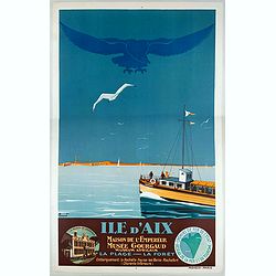
Ile d'Aix.
Travel poster for Chemin Fer created by the French artist Pierre Commarmond. The poster mentioning the attractions at the island of Aix, The Emperor House, The Gourgaud M...
- $750 / ≈ €661
Place & Date: Paris, Mayeux, 1930

Picardia Regio Belgica.
Map of the northern region of Picardy. The region is well known due to the 4 major battles fought between France, Britain and Germany between 1915-18 during World War I. ...
- $400 / ≈ €352
Place & Date: Amsterdam, 1644

- Allons donc, chers confrères .... vous avez tort de vous disputer hors de l'audience..... ce lieu ci doit être la salle des pas perdus pour les plaideurs..... mais jamais les avocats ne doivent y perdre des paroles......
Second state (of 2), with text, numbered 7. From "Les Gens de Justice", published " Chez Auber & Cie, Pl. de la Bourse,29". Text below image : Com...
- $900 / ≈ €793
Place & Date: Paris, 1848
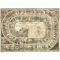
Jeu Royal de la vie d'Henri IV.
Large sheet with an animated Goose-game of 63 numbered squares, spiral, counterclockwise, centripetal focused on the French king Henri IV.André Basset offers the life of...
Place & Date: Paris, ca. 1816-1820

Kunst is allemaal flauwe kul.
Joop Schafthuizen is a Dutch artist known for his prints. He inspired some of the books written by his partner, the famous writer Gerard Reve. "Kunst is allemaal fla...
Place & Date: Rotterdam, 1976
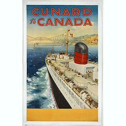
Cunard to Canada.
Poster by Charles Eddowes Turner for Cunard lines. The poster shows The NEW SYLVANIA, one of the four new 22,000 - ton Cunarders which are the largest ever built for serv...
Place & Date: England, ca. 1930
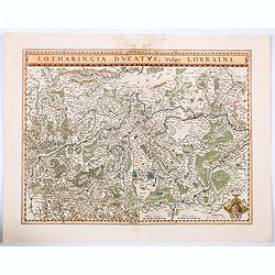
Lotharingia Ducatus vulgo Lorraine.
A very detailed map for his time centered on Nancy, Bayon and Metz, and including the river valleys of the Sar and Moselle. In the lower right-hand corner of the map is a...
Place & Date: Amsterdam, ca 1640
Selling price: $16
Sold in 2021

Mexico.
Unusual poster for Mexican tourism, published by Asociacion Mexicana de Turismo, The artist is unknown and the design is surreal and modern at the same time.The popularit...
Place & Date: Mexico, ca. 1935
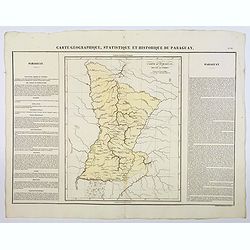
Carte Geographique, Statistique et Historique du Paraguay.
A nice detailed map of Paraguay from Buchon's Atlas Gégraphique Statistique, historique et chronologique des deux Ameriques et des isles adjacentes traduit de l'atlas ex...
Place & Date: Paris, 1825
Sarmatia utraque europaea et asiatica. . .
Ancient map of the European part of Russia with the Ukraine. Dated 1654.Nicolas Sanson was to bring about the rise of French cartography, although the fierce competition ...
- $300 / ≈ €264
Place & Date: Paris, 1654

Cafrerie et Monomotapa.
Uncommon miniature map of South Africa, from Pierre Duval's "La Geographie Universeille" dated 1676. Following his Cartes de geographie in 1657, Pierre Duval pu...
- $200 / ≈ €176
Place & Date: Paris, 1676
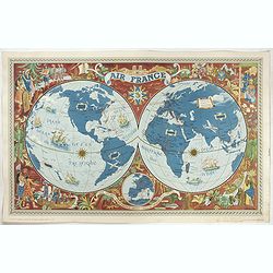
Sur les ailes d'Air France découvrez le monde à votre tour.
Promotional mid-size poster of a double hemisphere world map designed by Lucien Boucher for AIR France. The map depicts the entire world in rich blues and burgundies with...
- $1100 / ≈ €969
Place & Date: Imprimerie Goosens, Paris, 1952

Carte réduite de l'Océan Oriental, depuis Le Cap de Bonne Espérance jusqu'à l'Isle Formose.
French chart covering the seas between the Cape of Good Hope until Taiwan and the West Coast of Australia. Prepared by Jacques-François L'Abbé Dicquemare (1733-1789). L...
- $1000 / ≈ €881
Place & Date: Paris, Brest, chez Demonville, 1775
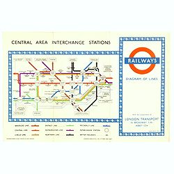
1953 Harry Beck London Underground map.
Published in the Queen's coronation year. A London Underground map (double sided).
- $150 / ≈ €132
Place & Date: London, 1953

New Guinea. Map illustrating Sir. w. Macgregor's route to the Owen Stanley Range 1889.
Map illustrating Sir. w. Macgregor's route to the Owen Stanley Range 1889. With inset map of South-East New Guinea.Fine colored lithograph map lithographed by Turner &...
- $50 / ≈ €44
Place & Date: London, Edward Stanford, 1890

AU CAFÉ D'AGUESSEAU. En attendant l'audience, Démosthène déjeune aux frais du client, le bifteck aux pommes pousse à l'éloquence...
Third state (of 3), with text, numbered 23. From "Les Gens de Justice", published " Chez Auber & Cie, Pl. de la Bourse,29". Text below image : AT ...
- $500 / ≈ €440
Place & Date: Paris, 1848

Nouvelle Carte pour conduire a la Connoissance de la Marine . . .
This is a fascinating folio sheet filled with engravings of ships and navigation instruments. At center is a large view of a frigate showing the rigging in great detail. ...
Place & Date: Amsterdam, 1720
Selling price: $1200
Sold in 2023

Westphalia Ducatus.
Elegantly engraved map of Westphalia including Hamm and Lippstadt. The mountainous topography is graphically depicted and several small coats of arms dot the map. Strapwo...
- $100 / ≈ €88
Place & Date: Amsterdam, 1629-1630

Planisphère.
One of the last decorative maps of the area. In side panels representations of the four seasons. In original out line color, from his "Atlas Universel Illustré"...
- $175 / ≈ €154
Place & Date: Paris, 1845-1860
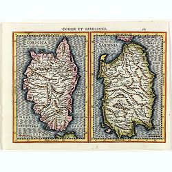
Corsse et Sardaigne.
Maps of Corsica and Sardinia from the rare Cloppenburg edition slightly larger format and more scarce edition of the Mercator/Hondius "Atlas Minor". Engraved by...
- $300 / ≈ €264
Place & Date: Amsterdam, 1630
![Asia secunda pars terrae in forma Pegasi. [Asia is presented as the mythical winged horse Pegasus.]](/uploads/cache/44699-250x250.jpg)
Asia secunda pars terrae in forma Pegasi. [Asia is presented as the mythical winged horse Pegasus.]
Wood block map of Asia in the form of a Pegasus. The seas are adorned with sea monsters and many major cities are indicated and named. There are several states, of this m...
Place & Date: Magdeburg c. 1581
Selling price: $1000
Sold in 2019
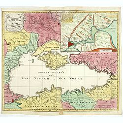
Nova Mappa Maris Nigri et Freti Constantino Politani. . .
Decorative and uncommon map the Black Sea region. In upper left hand corner an inset map (200 x 280mm) of the Bosporus including Istanbul. Title engraved onto a drape-sty...
- $450 / ≈ €396
Place & Date: Augsburg, ca. 1760
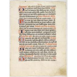
Leaf on vellum from a antiphonary.
A leaf from an Antiphonal or Choir Missal for Spanish use, in Latin, on extremely heavy vellum. Justification: 360x246mm. Text is in Spanish rounded gothic hand (Rotunda)...
Place & Date: Sevilla, ca.1520

Helleborus niger vulgaris flore roseo. Gemeine Schwartze-Niesswurtz.
Copper engraved print; overall size 36 x 22,5 cm from the German edition of Blackwell's 'Herbarium Blackwellianum...' or 'A Curious Herbal', originally published in Londo...
Place & Date: Nurnberg, 1757-1773
![CH'ONHA CHIDO [Atlas of all under Heaven]](/uploads/cache/33625-250x250.jpg)
CH'ONHA CHIDO [Atlas of all under Heaven]
The Ch’onha chido [Atlas of all under Heaven] is a late 18th century copy of the traditional Korean atlas produced in the early Choson dynasty (1392-1910). One of the m...
Place & Date: Korea, ca. 1790
Nova Totius Terrarum Orbis Geographica..
The first of four states of the map. French text on verso. One of the most beautiful world maps ever engraved and one of the most influential in promulgating the Californ...
Place & Date: Amsterdam, 1630-1633
![[Set of five maps] Carte Générale de la Terre ou Mappe Monde](/uploads/cache/41145X-250x250.jpg)
[Set of five maps] Carte Générale de la Terre ou Mappe Monde
Rare and decorative set of five wall maps of the world and the four continents, prepared by Clouet, in very fine bright contemporary coloring. Each map ca. 965 x 1230 mm ...
Place & Date: Paris and Cadiz, Mondhare, 1785-1793
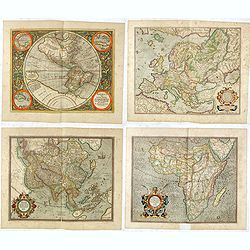
Set of four continents.
Fine set of 4 continents prepared by Gerard Mercator. The general map of Europe, as well as Americae Pars, Greenland, Iceland, a Polar landmass, along with the mythical i...
Place & Date: Amsterdam, 1628
![L' AMERIQUE divisee Par Grands Etats. [Great western sea , First State]](/uploads/cache/82868-250x250.jpg)
L' AMERIQUE divisee Par Grands Etats. [Great western sea , First State]
First state for this very important map. By far the most interesting aspects of this map deal with Janvier's treatment of the largely unexplored Pacific Northwest. A magn...
Place & Date: Paris, 1762
Benedict. Arias Montanus Sacrae Geographiae Tabulam Ex Antiq
THE EXTREMELY RARE FIRST STATE landmark world map, famed for its depiction of the Australian landmass.One of the earliest printed maps to depict the “terra incognita�...
Place & Date: Anvers 1571 /1572
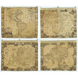
Matching set of four wallmaps of America, Asia, America, Europe.
Rare and decorative set of four wall maps published by Louis Charles DESNOS ( fl.1750-1770), including a border with vignettes describing native scenes. Each panel is acc...
Place & Date: Paris, 1760-1761
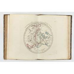
![Summa philosophiae quadripartita, de rebus dialecticis, moralibus et metaphysicis . . [ With unrecorded world map ]](/uploads/cache/28639-250x250.jpg)
Summa philosophiae quadripartita, de rebus dialecticis, moralibus et metaphysicis . . [ With unrecorded world map ]
On page 107 a finely copper engraved world map (88x84mm.) Paradigma Terrae Plagas 4.ac 12. Ventorum situm indicans., centered on Europe and Africa, with parts of America,...
Place & Date: Leiden, Peter Rigaud, 1626

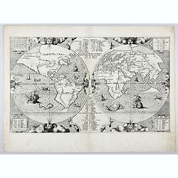
Mappemonde contenant les parties connues du globe terrestre dressée suivant de nouvelles observations
Wall map of the world in two hemispheres printed on two sheets, depicting the Eastern and Western hemispheres supported by two male figures, decorated at the bottom right...
Place & Date: Paris, Longchamps et Janvier, 1754
A new and correct map of the world.
The early eighteenth century was one of the most important periods for English cartography. One of the period's most intriguing world maps is this large-scale map, which ...
Place & Date: London 1714
![[Printed on silk] Nieuw Wassende Graaden Paskaart Vertoonende alle de bekende Zeekusten en Landen op den geheelen Aard Boodem of Werelt door Gerard van Keulen. . .](/uploads/cache/31640-250x250.jpg)
[Printed on silk] Nieuw Wassende Graaden Paskaart Vertoonende alle de bekende Zeekusten en Landen op den geheelen Aard Boodem of Werelt door Gerard van Keulen. . .
A very scarce and beautiful chart on Mercator's projection printed on silk. With the name of Gerard van Keulen and the privilege. The map shows great interior detail, inc...
Place & Date: Amsterdam, 1728

Die zee custe van Noorweghen tusschen der Noess en Mardou. . .
A rare Dutch text edition of this early and detailed chart of the coast of Norway. Decorated by a colorful title cartouche and scale cartouche, one compass rose, several ...
Place & Date: Leiden, Plantijn, 1585
Selling price: $2500
Sold in 2024
![[Title page to] Atlas mayor, o geographia Blaviana : Que contiene las cartas, y descripciones de Partes Orientales de Europa.](/uploads/cache/29952-250x250.jpg)
[Title page to] Atlas mayor, o geographia Blaviana : Que contiene las cartas, y descripciones de Partes Orientales de Europa.
Title page from a Spanish text edition of the Atlas Major. Ionic portico with celestial and terrestrial globes. To the left is Ptolemy with a sphere and a pair of compass...
Place & Date: Amsterdam, c.1672
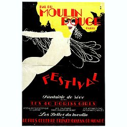
Bal du Moulin Rouge Paris - Femmes Femmes Femmes.
Poster designed by René Gruau for Bal du Moulin Rouge Paris - Festival fantaisie de rêve avec les 40 Doris Girls. Signed in the upper right-hand corner with Monogram G....
Place & Date: Paris, Artis SA Paris, 1973
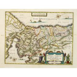
Terra Sancta quae in Sacris Terra Promissionis..
Orientated west to the top. The decoration is inspired by the Old Testament. Moses stands to the left of the cartouche, Aaron to the right: in the Mediterranean a giant s...
Place & Date: Amsterdam, 1640
Lotharingiae Tabula Generalis.
Decorative map of Lotheringen.
Place & Date: Nuremberg, 1730
Atlas general A L'Usage Des Colleges Et Maisons..
Rare atlas, published by Mondhare, maps dated 1780,1781 and 1793. Usually bright, attractive copy for a work of this kind. As announced in its title, this work was specif...
- $6000 / ≈ €5286
Place & Date: Paris, 1791
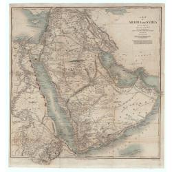
A Map of Arabia and Syria Laid Down Chiefly From Original Surveys Under the Superintendence of Lieut. Colonel Chesney, R.A.F.R.S. and drawn by W. H. Plate. L.L. D
This is one of the most significant and detailed maps of Arabia and the Persian Gulf. It is drawn by Plate using various sources. As stated below the cartouche the source...
Place & Date: London, 1849
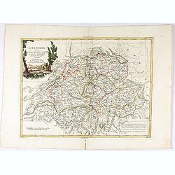
L'Elvezia divisa ne suoi Tredici Cantoni e suoi Alleati di nuova projezione.
Antonio Zatta's detailed map of the Confederation of Switzerland divided into its thirteen Cantons and their allies. Shows political and administrative boundaries, cities...
Place & Date: Venice, 1781
![Mapa geral do Brasil / organizado pelos J. Carneiro da Silva e Pedro Voss. [Together with] Micro geografia do Brasil. [Together with] Pequeno Mapa do Brasil.](/uploads/cache/45466-250x250.jpg)
Mapa geral do Brasil / organizado pelos J. Carneiro da Silva e Pedro Voss. [Together with] Micro geografia do Brasil. [Together with] Pequeno Mapa do Brasil.
Large folding national map published by "Comp. Melhoramentos de São Paulo Industrias de Papel". Nova edicao revista 1946. Figurs all states. "Futuro Distr...
- $300 / ≈ €264
Place & Date: São Paulo, 1946

Tobago.
A delightfully detailed map of the West Indian island Tobago by John Thomson. The map displays excellent detail concerning roads, rivers, towns, bays, harbors, and other ...
- $50 / ≈ €44
Place & Date: Edenburgh, 1821
![[Title page] Nouvelles vues perspectives des Ports de France, dessinées pour le Roi . . .](/uploads/cache/41603-250x250.jpg)
[Title page] Nouvelles vues perspectives des Ports de France, dessinées pour le Roi . . .
Title page of "Nouvelles vues perspectives des Ports de France".
Place & Date: Paris, 1776
Selling price: $35
Sold in 2023
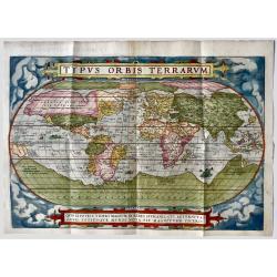
Typus Orbis Terrarum.
Ortelius' Landmark World Map - 1st state, 1st Edition. French text on verso. One of the most famous world maps ever made, "Typus Orbis Terrarum" featured in the...
Place & Date: Antwerp, 1572
Selling price: $5000
Sold in 2019
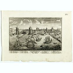
La Ville de la Rochelle, Capitale du pays d'Aunis. . .
A very decorative town view of La Rochelle.
- $350 / ≈ €308
Place & Date: Paris, 1700
![[ The repositioning of the Vatican obelisk ]](/uploads/cache/49045-250x250.jpg)
[ The repositioning of the Vatican obelisk ]
Joan Blaeu published The Repositioning of the Vatican Obelisk. This large engraving on multiple sheets and in beautiful original colors is based on Domenico Fontana’s d...
Place & Date: Amsterdam, 1649

Prussia .
An early map of northern Poland from the "Atlas Minor" (Gerhard Mercator / Jodocus Hondius). Extends from Memel to Torun and the Narew River. With two sailing s...
- $300 / ≈ €264
Place & Date: Amsterdam, 1612

Vous avez perdu votre procès c'est vrai ..... mais vous avez du éprouver bien du plaisir à m'entendre plaider.
Second state (of 2), with text, number (35) erased. From "Les Gens de Justice", published " Chez Auber & Cie, Pl. de la Bourse, 29". Text below im...
- $750 / ≈ €661
Place & Date: Paris,1848
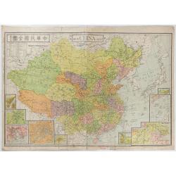
New China Map.
Very large and detailed map of China (1:6,000,000) printed in Shanghai, June 27th 1938 by JIN-SHIN GEOGRAPHICAL INSTITUTE.The title and place names in Chinese and Engli...
- $900 / ≈ €793
Place & Date: Shanghai, June 27th 1938
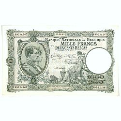
1000 Francs ou 200 Belgas (Belgian bank note)
The National Bank of Belgium issued Belgian Franc banknotes in 10 different denominations, including this 1000 Belgian Francs 200 Belgas banknote (Série Nationale). They...
Place & Date: Belgium, after 1928
Selling price: $15
Sold in 2025

Royaume de Corée.
With a quite elaborately pictorial cartouche, engraved by G.Kondet. One of the earliest separate maps of Korea. Jean Baptiste Bourguignon d' Anville (1697-1782), French c...
Place & Date: The Hague, 1737

Carte Geographique, Statistique et Historique du New Hampshire.
A detailed map of New Hampshire, from Buchon's Atlas Gégraphique Statistique, historique et chronologique des deux Ameriques et des isles adjacentes, traduit de l'atlas ...
Place & Date: Paris, 1825
Selling price: $50
Sold in 2019
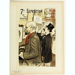
7eme Exposition du Salon des 100.
Chromo lithographed poster of Les Maîtres de l'Affiche being plate n°15. The "Les Maîtres de l'Affiche" contained 256 small for lithographic prints of the be...
Place & Date: Paris, Imprimerie Chaix, 1896
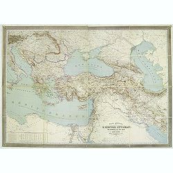
Carte générale de L'Empire Ottoman en Europe et en Asie dressée par Henri Kiepert . . .
Large School wall map of Turkish Empire printed in chromo-lithography. Published by Dieter Reimer and printed by Ferdind Barth in Berlin. This rare map has two insets in ...
Place & Date: Berlin, Verlag von Dietrich Reimer, 1867

Ducatus Prussiae tam Polono Regiae. . .
Rare issue of Frederick de Wit's attractive map of the northern part of Poland, Prussia and the Baltic regions.Very decorative title cartouche including 3 coats of arms. ...
- $3500 / ≈ €3083
Place & Date: Amsterdam, 1698
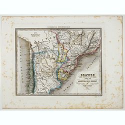
Brasile Parte Sud Argentina, Chili, Uruguay e Paraguay.
Uncommon map of Brasile Southside, Argentina, Chili, Uruguay and Paraguay. northside prepared by Francesco Costantino Marmocchi. Above the map "Geografia Commerciale...
Place & Date: Genova, Paolo Rivara fu Giacomo, 1858
Selling price: $15
Sold in 2022

Souvenirs des Pyrénées. Vues prises aux environs des eaux thermales de Bagnères-de-Bigorre, Bagnères-de-Luchon, Cauteretz, Saint-Sauveur, Barèges, Les-eaux-Bonnes, Les-Eaux-Chaudes & Pau.
The thermal baths Bagnères de Bigorre, Bagnères de Luchon, Cauteretz, Saint-Sauveur, Barèges, Les Eaux-Bonnes and Pau in the Pyrenees. Beautiful collection of 24 litho...
Place & Date: Pau, A.Basset, ca. 1860

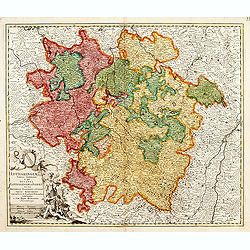
Ducatus Silesiae Glosani.
Charming map of the Silesia from the Mercator Hondius “Atlas Minor” published in Amsterdam in 1648 at Janssonius with German text on verso. Engraved by Petrus Kaerius...
- $200 / ≈ €176
Place & Date: Amsterdam, 1648