Wish List
With WishList / Virtual Collection, you can save and collect your favorite items in one place, it is free and you can delete an item from your list at any time.
Save any of the 30.000+ maps, prints or Medieval manuscripts from our BuyNow Catalog or Catalog Archive.
Unless logged in, an item is only saved for that session. If you want to save the items permanently, please log in first.
![[How the Inca nobility are buried] / [Bridge of Huaynacapaco]](/uploads/cache/41094-250x250.jpg)
[How the Inca nobility are buried] / [Bridge of Huaynacapaco]
Two engravings. [470] The funeral of an Inca king was a ceremony of great splendor. After digging a large pit, the Indians would decorate the corpse with gold and silver ...
Place & Date: Frankfurt, M.Merian, 1633
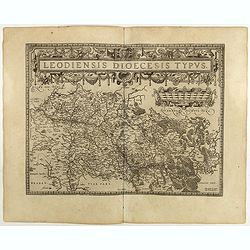
Leodiensis Diocesis Typus.
East to the top. Centered on Liege, including the southern part of Dutch Limburg. Prepared by Jan van Schille.Dare to go in Black. All early maps were printed in black an...
Place & Date: Antwerp, 1598
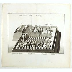
Observatoire de Peking.
The observatory of Mateo Rizzi in Peking, in which there are very large instruments, an Equinoctial Sphere, a Celestial Globe, a Zodiacal Sphere, Azimuthal Horizona, Quad...
- $200 / ≈ €176
Place & Date: Paris, GROSIER Jean-Baptiste, 1785
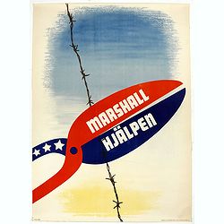
Marshall Hjälpen.
Marshall Plan poster made by Gusta Aberg, showing barbed wire cut by pliers with slogan on pliers: Marshall Hjälpen This is one of the 25 finalists in the 1950 “Intra-...
Place & Date: Kühn & Zoon Rotterdam, 1950
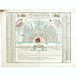
Tableau figuratif de la Chambre de Députés . . .
Figurative table of the Chamber of Deputies for the session of 1821. Showing as accurately as possible the place usually occupied by each of its members.
Place & Date: Paris, ca. 1821
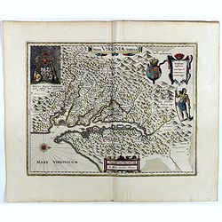
Nova Virginiae Tabula.
A fine example of Blaeu's map of Virginia and the Chesapeake region is based on the first state of Smith's map, 1612, and is slightly larger and more expertly engraved.Th...
Place & Date: Amsterdam, 1640
![[Russian Agitprop propaganda poster for 9 May]](/uploads/cache/42073-250x250.jpg)
[Russian Agitprop propaganda poster for 9 May]
Soviet propaganda poster celebrating Victory Day (Thursday 9 May). Showing a star with USA, English, French flags partly overlapped with Soviet flag and inscription in Ru...
Place & Date: Moskow, 1988

Tavola nuova di Prussia et di Livonia.
Uncommon first edition of this early map of the region from Pomerania to Livonia, includes a portion of Estonia, and coastal detail on the Baltic Sea with a small section...
- $400 / ≈ €352
Place & Date: Venice, Vincenzo Valgrisi, 1561
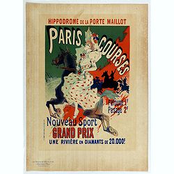
Hippodrome de la porte Maillot. Paris Courses.
Chromo lithographed mini poster, " Hippodrome de la porte Maillot. Paris Courses. Pelouse 1 f. pesage 2 f. Nouveau sport. Grand prix : une rivière en diamants de 20...
Place & Date: Paris, Imprimerie Chaix, April 1897
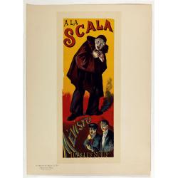
A la Scala, Mevisto.
Chromo lithographed poster, "A la Scala, Mevisto.", by LUCE, M. Plate 139, published in Maître 17, on April 1898. The "Les Maîtres de l'Affiche" con...
Place & Date: Paris, Imprimerie Chaix, April 1898
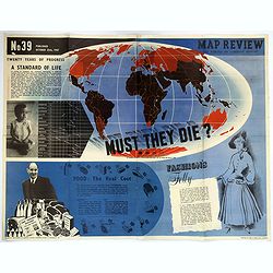
Map Review No.39. - Twenty Years of Progress, 'A Standard of Life'.
A large fully colored double-sided poster of the world colored to highlight the number of children who die each year before the age of one. This is accompanied by a short...
- $200 / ≈ €176
Place & Date: London, 1947
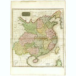
China.
Highly detailed map of China including Formosa (Taiwan), Hainan, and part of Luzon in the Philippines. The map show the Tract of the Hindoostan and Lion with the British ...
Place & Date: Edinburgh, 1815
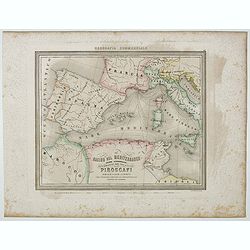
Bacino del Mediterraneo (Parte occidentale) . . .
Uncommon map of Mediterranean Basin prepared by Francesco Costantino Marmocchi. Above the map "Geografia Commerciale". From "Il Globo Atlante di carte Geog...
- $50 / ≈ €44
Place & Date: Genova, Paolo Rivara fu Giacomo, 1858
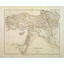
Turkey in Asia.
A lovely looking steel engraved map of Turkey in Asia. Map extent is Asia Minor, Syria, Holy Land, across to the Caucasian peoples that inhabit the lands between the Blac...
Place & Date: London, 1839
![Jules Verne Le Tour du Monde en 80 jours. [Goose game board inspired by Jules Verne's novel Tour du Monde en 80 jours.]](/uploads/cache/44919-250x250.jpg)
Jules Verne Le Tour du Monde en 80 jours. [Goose game board inspired by Jules Verne's novel Tour du Monde en 80 jours.]
Goose game board inspired by Jules Verne's novel, whose boxes are illustrated with color lithographs and the center occupied by a world map. Vignette illustrations number...
Place & Date: Paris, ca. 1880

Nova Belgica et Anglia Nova.
Orientated with north to the right. This is one of the earliest maps to concentrate solely on this area of the colonies, excluding Virginia and the extreme north east coa...
- $3000 / ≈ €2643
Place & Date: Amsterdam, 1644

Espagne.
Rare map of Spain and Portugal, published by Jollain in 1667. Published in "Trésor Des Cartes Geographiques Des Principaux Estats de Lunivers".This atlas is ba...
- $200 / ≈ €176
Place & Date: Paris, 1667
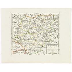
L'Archiduché d' Autriche et les Duchés de Stirie, Carinthie et Carniole.
Small detailed map of the eastern part of Austria, including Slovenia and part of Italy.From Atlas Portatif Universel, by Robert de Vaugondy. Edited by : "Au dépôt...
- $30 / ≈ €26
Place & Date: Paris, 1799

Livoniae Descrip.
A rare miniature map of the Baltic States Estonia, Latvia & Lithuania. The present map is one of the earliest obtainable maps to focus this region. Title cartouche o...
- $200 / ≈ €176
Place & Date: Amsterdam, 1618
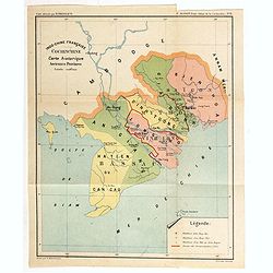
Indo-Chine Française Cochinchine. Carte historique Anciennes Provinces.
Charming map of the southern third of current Vietnam whose principal city is Saigon or Prey Nokor in Khmer. It was a French colony from 1862 to 1954.Prepared by R.Brissa...
- $150 / ≈ €132
Place & Date: Saigon, Librairie Brunet. c.1920
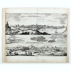
Die stadt Narva . . .
Two panoramic views of the city of Narva, on one sheet. Narva is the third largest city in Estonia. It is located at the eastern extreme point of Estonia, at the Russian...
- $250 / ≈ €220
Place & Date: Schleßwig, Zur Glocken, 1647
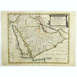
Carte des Trois Arabies. Tiree en Partie de l'Arabe de Nubie, en Partie de Divers autres Autheurs. . .
Rare map of the Arabian Peninsula, first published in 1654 and one of the first large maps focused specifically on the Arabian Peninsula. Sanson's map of the Arabian Peni...
Place & Date: Paris, 1654

India Orientalis Nova.
Charming uncommon miniature map showing the northern two-thirds of Australia pre-discoveries by Captain Cook, but showing discoveries by Abel Tasman in 1642. The map show...
- $750 / ≈ €661
Place & Date: Amsterdam, 1659
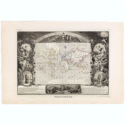
Planisphère.
One of the last decorative maps of the area. In side panels representations of the four seasons. In original o.l. color, from his "Atlas Universel Illustré". T...
Place & Date: Paris, A. Combette, 1852
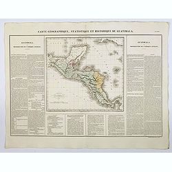
Carte Geographique, Statistique et Historique de Guatimala.
A nice detailed map of Guatemala from Buchon's Atlas Gégraphique Statistique, historique et chronologique des deux Ameriques et des isles adjacentes traduit de l'atlas e...
Place & Date: Paris, 1825

Vue et description de la Ville de Meaco Capitale du Japon. . .
Top part of the print shows the town of Meaco (Kyoto) at that time the capital of Japan, with a coach and horses in the foreground. Other parts show among other things th...
- $450 / ≈ €396
Place & Date: Amsterdam, 1720
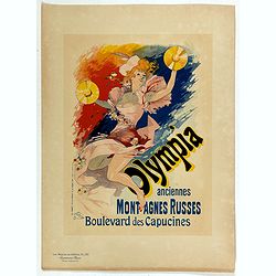
Olympia anciennes montagnes Russes.
Chromo lithographed poster, "Olympia anciennes montagnes Russes.", by CHERET, J. Plate 133, published in Maître 17, on April 1898. The "Les Maîtres de l'...
Place & Date: Paris, Imprimerie Chaix, April 1898
![Manila the perl of the Orient. Guide book to the intending visitor [with several photos and 3 plans of Manila]](/uploads/cache/48356-250x250.jpg)
Manila the perl of the Orient. Guide book to the intending visitor [with several photos and 3 plans of Manila]
Charming 1908 Guide book to with several photos and 3 folding plans of Manilla. Published by the "Manila merchants' association", directed by O'Connell, Daniel....
Place & Date: Manilla, 1908
L'Isle de CORSE Divisée en ses departemens.
Nice map of Corsica, with a decorative cartouche in the left low corner. Small inset map of Sicily in the upper right corner: "Pointe de Capo Corso".This is the...
- $1750 / ≈ €1542
Place & Date: Venise,1805
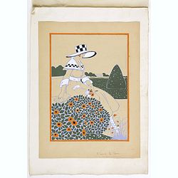
Art déco gouache.
Outstanding "art deco" gouache (unsigned) from the workshop of "Robert Pichon. Ateliers de Dessin et Lithographie – 10, rue Rochechouart – Paris. The ...
Place & Date: Paris, ca. 1930
Nieuw Nederlandtsch Caertboeck. Waer in volkomentlijcker als oyt te voren vertoont werden de XVII. Nederlanden.
Rare first edition of this atlas of the provinces of the Netherlands, Belgium and Luxemburg. Engraved title page, with : "Gedruckt t' Amsterdam by Abraham Goos Plaet...
Place & Date: Amsterdam, 1616

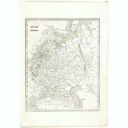
Russia cum Confinijs.
Charming small map of European Russia. Nicely detailed including engraved forests and mountains and embellished with two strapwork cartouches. Latin text on verso.
- $220 / ≈ €194
Place & Date: Amsterdam, 1634
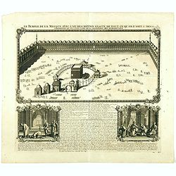
Le temple de la Mecque avec une description de tout ce qu'on y voit . . .
Fascinating engraving depicting the Muslim Kaaba at Mecca. Below the main image are two smaller vignette images of people praying. In between the two vignettes is a key (...
Place & Date: Amsterdam, 1728
Selling price: $1000
Sold in 2024

Les Gens de Justice. - Une Péroraison à la Démosthène (pl 33)
Second state (of 2), with text. From "Les Gens de Justice". Text below image : - Une Péroraison à la Démosthène . Around the mid-1840s Daumier started publi...
Place & Date: Paris, 1845-1848
![[Original Chinese advertising poster for Gande, Price & Co., Ltd. Hong Kong]](/uploads/cache/45059-250x250.jpg)
[Original Chinese advertising poster for Gande, Price & Co., Ltd. Hong Kong]
Original vintage Chinese poster for "GANDE, PRICE & CO. LTD., based in Hong Kong, promoting Haig Whisky (from Scotland), Moet & Chandon, Taylor’s London Dr...
Place & Date: Shanghai, 1934

Carte du Cours du Menam . . .
Map of the Menam Riviera. Across the top is an extensive list of 22 important sites and locations keyed to the plan with tiny letters and numbers.Jacques Nicolas Bellin (...
- $200 / ≈ €176
Place & Date: Paris, 1750

Incliti Cantonis Friburgensis Tabula, autore Francisco Petro VON DER WEID. Senatore et Commissario generale Friburgi. anno Domini 1668.
Very rare 2-sheet map and the first map of the canton Fribourg (Freiburg) in a scale of Scale 1:120.000. South to the top.The area shown on the map encompasses the whole ...
Place & Date: Fribourg, 1668
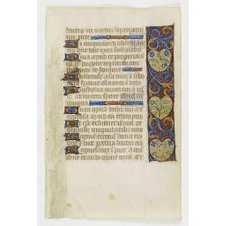
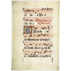
Leaf on vellum from an antiphonary.
A very fine antiphonary leaf, written in Latin , probably Rome. RECTO: A wonderful initial ,O, decorated with pen work in red, white and blue, in rich burnished gold.VERS...
- $600 / ≈ €529
Place & Date: Italy, 1480
Belgii sive Germaniae Inferioris accuratissima tabula.
Very rare and very decorative map with in the right and left borders costumed figures and town plans alternately. In top and bottom border town plans and views.Separate p...
Place & Date: Amsterdam, 1631
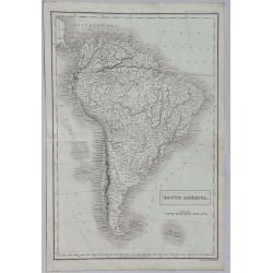
South America.
A detailed map of South America from Sidney Hall's extremely scarce 1835 “New General Atlas”. Adam & Charles Black were among the leading publishers of atlases an...
Place & Date: London, 1835
Selling price: $70
Sold in 2022
![[Original Chinese advertising poster for ] Hataman cigarette brand.](/uploads/cache/45071-250x250.jpg)
[Original Chinese advertising poster for ] Hataman cigarette brand.
This poster, an advertisement for Hataman Cigarettes from the 1930s, melds the meticulous detail of traditional Chinese painting with the craft of color lithography. It d...
- $200 / ≈ €176
Place & Date: Shanghai, 1934
Contado DE Venassino, E prencipato d'Oranges . . .
A most attractive and decorative map centered on Avignon and Orange, by Vincenzo Coronelli. An elaborate title cartouche garlanded with intertwined flowers and dedicated ...
- $400 / ≈ €352
Place & Date: Venise 1690
Russie d'Europe.
Detailed map of European Russia, prepared by Charles V. Monin (fl.1830-1880) a French cartographer of Caen and Paris. Published in Atlas Universel de Géographie Ancienne...
- $25 / ≈ €22
Place & Date: Paris, 1845

Paraguayo prov. de Rio de La Plata cum regionibus..
A beautiful map of Paraguay, and parts of Peru, Chile, Argentina, Brazil and Bolivia. Much of the area was still "Terra Incognita" so there are few towns and ci...
- $600 / ≈ €529
Place & Date: Amsterdam, 1644
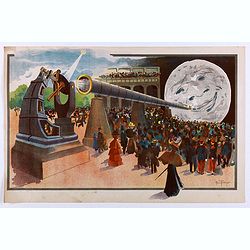
La Lune à un Mètre [Mini poster for Paris Exposition Universelle)
Original lithograph poster for "Paris Exposition Universelle" held between April and November, 1900, which received 50 million visitors. In 1899, director Geor...
Place & Date: Paris, c.1900

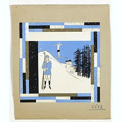
Art déco
Outstanding "art deco" gouache (unsigned) from the workshop of "Robert Pichon. The gouache depict a scene of four people skiing and holly in the first plan...
Place & Date: Paris, ca. 1930
(Art déco gouache)
Outstanding "art deco" gouache (unsigned) from the workshop of "Robert Pichon. Ateliers de Dessin et Lithographie – 10, rue Rochechouart – Paris. The g...
Place & Date: Paris, ca. 1930

Perspective print by Vredeman de Vries. 21.
Engraving from Perspective, c'est a dire, le tres renomme art du poinct oculaire d'une veue dedans ou travers regardante, estant sur une muraille unie, sur un tableau, ou...
- $125 / ≈ €110
Place & Date: The Hague, 1604 - 1605

Le Indie Ocidentali ( Antille maggiori e minori, ecc) L'America Centrale . . .
Uncommon map of Central America and the Antilles prepared by Francesco Costantino Marmocchi. Above the map "Geografia Commerciale". From "Il Globo Atlante ...
Place & Date: Genova, Paolo Rivara fu Giacomo, 1858
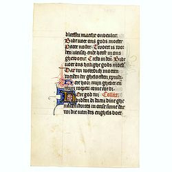
Leaf on vellum from a manuscript Book of Hours.
RECTO: Panel border of acanthus leaves and flowers on a partly liquid gold and dark red ground, height 1-line initial in liquid gold on colored grounds and three line fil...
Place & Date: France, ca. 1420-1480
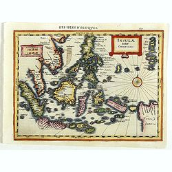
Insulae Indiae Orientalis.
Map of South East Asia with good detail on the Philippines from the rare Cloppenburg edition slightly larger format and more scarce edition of the Mercator/Hondius "...
Place & Date: Amsterdam, 1630
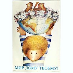
Protect the globe!, 1989.
USSR propaganda poster, with the slogan "protect de globe". A child holding a globe with flowers and birds.
Place & Date: Russia, 1989
A View of Astracan. (Astrakhan)
A striking and highly detailed copper engraved panoramic view of Astrakhan, Russia, with its buildings, churches and town wall. The River Volga in the foreground. Several...
- $50 / ≈ €44
Place & Date: London, 1820
Leaf on vellum from an antiphonary.
A very fine antiphonary leaf, written in Latin, probably Rome. RECTO: A wonderful initial "I" decorated with penwork in red, white and blue, in rich burnished g...
- $1000 / ≈ €881
Place & Date: Italy, 1480

Leaf on vellum from an antiphonary.
A very fine antiphonary leaf, written in Latin, probably Rome. RECTO: The staves are in red and the notes are in black.VERSO: The staves are in red and the notes are in b...
- $750 / ≈ €661
Place & Date: Italy, 1480

Illuminated leaf from a Psalter.
Very fine 20 lines illuminated leaf from a liturgical Psalter in Latin with the reading from the Vulgate Bible. Lines in a slightly irregular gothic hand, black ink, plum...
Place & Date: Flanders, Rhineland, or possibly England, c. 1280
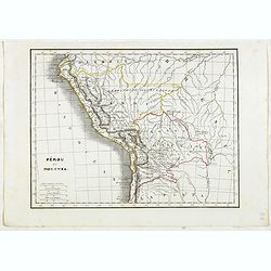
Pérou et Bolivia.
Detailed map of Peru and Bolivia, prepared by Charles V. Monin (fl.1830-1880) a French cartographer of Caen and Paris. Published in Atlas Universel de Géographie Ancienn...
- $45 / ≈ €40
Place & Date: Paris, 1845
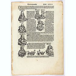
Tercia Etas Mundi. Folium. XXXVII
The Latin text page is illustrated with a depictions of Kings, Noble men and women and scientists. Page from the richest illustrated Incunable, the famous: Nuremberg Chro...
- $100 / ≈ €88
Place & Date: Nuremberg, 12 July 1493
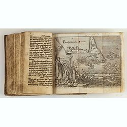
Reiß in das Gelobte Land ... Mit nach dreyen andern Reißbeschreibungen vermehret, und schönen Kupfern gezieret.
Very rare first illustrated edition of collected travel accounts by citizens of Zürich, containing : Hans Jacob Amman, "Narrative of a trip to Palestine". The ...
Place & Date: Zürich, M. Schauffelberger Erbin, 1678

Vue Perspective de la Place des Victoires
So-called optical print of la Place des Victoires in Paris. Therefore the image is reversed or mirror-image. One of the well-known publishers of optical prints, establish...
- $100 / ≈ €88
Place & Date: Paris, 1780

De Zuydwest-Kust van Het Eyland Ceylon.
A finely engraved and detailed chart of Punta Gala harbour.Very rare: only included in 6th volume (so-called secret atlas) of Van Keulen's. A lettered key in upper left c...
- $1000 / ≈ €881
Place & Date: Amsterdam, 1753
Manuscript leaf on vellum from a Dutch Book of Hours.
VERSO: Two 2-line capitals in burnished gold with extensive penwork in blue and red. Two 1-line capitals in red, blue or burnished gold with extensive penwork.RECTP: One ...
- $300 / ≈ €264
Place & Date: Utrecht, c.1400-1410
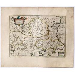
WALACHIA, SERVIA, BULGARIA, ROMANIA.
A decorative, striking example of Blaeu's map of the Lower Danube, Bulgaria, Romania, Serbia and Macedonia.
Place & Date: Amsterdam, 1619
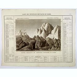
Carte des Principales Montagnes du Globe.
A nice detailed depiction of the principal mountains of the world from Buchon's Atlas Gégraphique Statistique, historique et chronologique des deux Ameriques et des isle...
Place & Date: Paris, 1825
La tierce aage. Feuillet ix rr.
Incunable text pages from "La Mer des Hystoires" published in 1488 by Pierre Le Rouge in Paris. "La Mer des Hystoires" is a translation into French of...
- $50 / ≈ €44
Place & Date: Paris, Pierre Le rouge, 1488
![Nova & exacta Chorographia Latii sive Territorii Romani iuxta veterem et novum situm parallela nomimu[m] comparatione elaborata.](/uploads/cache/44863-250x250.jpg)
Nova & exacta Chorographia Latii sive Territorii Romani iuxta veterem et novum situm parallela nomimu[m] comparatione elaborata.
Map of central Italy, centered on Rome from "Latium" by A. Kircher and designed by Innocenzo Mattei. The title cartouche in the lower right, small legend with 1...
Place & Date: Amsterdam, 1671

Perspective print by Vredeman de Vries. 23.
Engraving from Perspective, c'est a dire, le tresrenomme art du poinct oculaire d'une veue dedans ou travers regardante, estant sur une muraille unie, sur un tableau, ou ...
- $115 / ≈ €101
Place & Date: The Hague, 1604 - 1605

Oceana or Pacific Ocean.
A lovely detailed map of the Pacific, centered on Hawaii, from an early edition of Tanner's New Universal Atlas. From Russian America (AK) to Patagonia, and from New Zeal...
- $100 / ≈ €88
Place & Date: Philadelphia, ca 1840
Leaf on vellum from a manuscript Book of Hours.
Charming small manuscript leaf from an French Book of Hours written around 1470 in or near Rouen.VERSO: 14 Lines of text in Latin five 1-lines initial in liquid gold on b...
- $150 / ≈ €132
Place & Date: France, ca.1470

The Kingdome of China.
A most sought-after map of China. Decorative border vignettes including views of the cities of Quinzay and Macao along the top border with the wheeled wind machines and p...
Place & Date: London, G. Humble, 1626
Trop d'Appetit par A. Le Petit.
Dated in lower right dated "Le 9 juin 1875". The drawing is representing an alligator's jaw wearing a Prussian helmet, and about to chew a globe. Alfred Le Peti...
Place & Date: Paris, 1875

Descriptio Burgundiae Ducatus.
A decorative small map of region around Dijon, Chalons and Dole in Burgundy. Shows many rivers including the Seine, Saone and Brune. It features a nice strap-work title, ...
- $100 / ≈ €88
Place & Date: Amsterdam, 1606
![[Planisphère] - Crédit Lyonnais - Fondé en 1863. Afrique du Nord à Union Française.](/uploads/cache/44865-250x250.jpg)
[Planisphère] - Crédit Lyonnais - Fondé en 1863. Afrique du Nord à Union Française.
Original pictorial lithographed advertising poster showing the western part of Africa. Published by the French bank Crédit Lyonnais.Design by Lucien_Boucher who is a fam...
Place & Date: Paris, 1950
A new mape of Ye XVII Provinces of Low Germanie.
Showing all 17 Provinces of the Netherlands before the split between Spain and the Protestant Provinces under the House of Orange.The map was first published. At the same...
Place & Date: London, 1676
Gouvernement General de Languedoc. Divise en ses Vint Deux Diocesez.
A lovely late seventeenth century map of the central south French region of Languedoc, part of which borders the Mediterranean Sea by Dutch publisher and cartographer, Fr...
- $250 / ≈ €220
Place & Date: Amsterdam, ca 1680

Japonia Regnum.
The first map to correctly show Korea as a peninsula. This was to remain the standard form of Japan until the eighteenth century and although replaced by the maps of Rela...
- $2000 / ≈ €1762
Place & Date: Amsterdam, 1655

Prospectus Castelli Boxmerce / Prospectus Castelli Asten.
Early view of the castle of Boxmeer, engraved by H. Causé after a design by J. van Croes and published in "Vermakelykheden van Brabant en deszelfs onderhoorige land...
- $35 / ≈ €31
Place & Date: Amsterdam, 1696
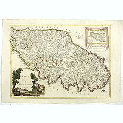
![[Map of Morea]](/uploads/cache/45228-250x250.jpg)
[Map of Morea]
Very rare map of the island Morea published in the first edition of "Viaggio da Venetia, a Costantinopoli. Per Mare, e per Terra, & infieme quello di Terra Santa...
- $450 / ≈ €396
Place & Date: Venice, Giacomo Franco, 1598

Virginiae Partis Australis, et Floridae Partis Orientalis.
Blaeu based this map on the Mercator-Hondius of 1606. A number of geographical improvements, however were incorporated, although two large fictions lakes accompanied by e...
- $1500 / ≈ €1321
Place & Date: Amsterdam, 1644
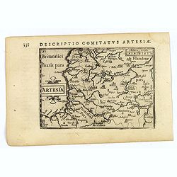
Artesia.
A decorative miniature map of Artois, a historical northern French province that borders Belgium. A map full of detail and is expertly engraved. With the cities of Boulo...
- $100 / ≈ €88
Place & Date: Amsterdam, 1606