Wish List
With WishList / Virtual Collection, you can save and collect your favorite items in one place, it is free and you can delete an item from your list at any time.
Save any of the 30.000+ maps, prints or Medieval manuscripts from our BuyNow Catalog or Catalog Archive.
Unless logged in, an item is only saved for that session. If you want to save the items permanently, please log in first.
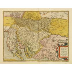
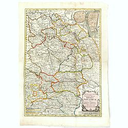
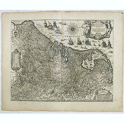
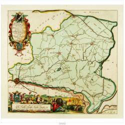
Illyricum.
Early map of Istria and Slovenia. Prepared by Johann Sambucus 1572.The map is in a strictly contemporary coloring.Read more about coloring.
- $400 / ≈ €352
Place & Date: Antwerp, 1574

Daniel Meisnerus Comment. Boh. Poeta Laur. Caes.
Very skillfully engraved portrait of Daniel Meisner from a rare work printed by Eberhard Kieser: Thesaurus Philo-Politicus. Das ist Politisches Schatzkästlein guter Herr...
- $200 / ≈ €176
Place & Date: Frankfurt, 1625

Nouveau jeu des théatres de Melpomene, Momus et Thalie.
Game board with 63 numbered pictorial compartments, each showing an actor or actress in role, lettered with his or her name, the name of the character, the play and the t...
- $1100 / ≈ €969
Place & Date: Paris, ca. 1810

Leaf on vellum from a antiphonary.
A leaf from a Medieval Antiphonal or Choir Missal for Spanish use, in Latin on extremely heavy vellum. Justification: 360x246mm. Text is in Spanish rounded gothic hand (R...
Place & Date: Sevilla, ca.1520
Selling price: $100
Sold in 2021
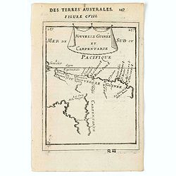
Nouvelle Guinée et Carpentarie.
A charming map of part of Papua New Guinea and the Gulf of Carpentaria in Australia. Title in curtain draped at top. French text on verso.From the original 1683 text edit...
Place & Date: Paris, 1683
Selling price: $75
Sold in 2022
![[Title page] Libellus Novus Politicus.. Pars Tertia.](/uploads/cache/38481-250x250.jpg)
[Title page] Libellus Novus Politicus.. Pars Tertia.
Very skillfully engraved title page from a rare work printed by Eberhard Kieser: Thesaurus Philo-Politicus. Das ist Politisches Schatzkästlein guter Herren und bestendig...
- $80 / ≈ €70
Place & Date: Frankfurt, 1626
USSR.
A proof state of the rare USSR Air France poster created by Georges Mathieu. In the initial series of 15 posters, the USSR was forgotten and has been published separately...
Place & Date: Paris, 1967
Selling price: $400
Sold in 2021

François.
A charming engraving of a French couple in 17th-century dress.Title in a curtain draped at top. French text on verso.From the original 1683 text edition of "Descript...
Place & Date: Paris, 1683
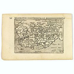
Caletensium et Bononiesium def.
An decorative miniature map of the N.W. France, including Calais and Boulogne. A map full of detail and attractive embelishments. North is orientated to the left. From th...
- $100 / ≈ €88
Place & Date: Amsterdam, 1606
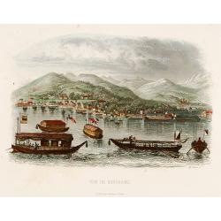
Vue de Nangasaki.
Steel engraved of Nagasaki from the water, identifying clearly Deshima, the V.O.C. trading post and the Dutch flag. Japanese and Chinese sloops in the fore ground. Engra...
- $125 / ≈ €110
Place & Date: Paris, 1842
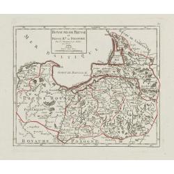
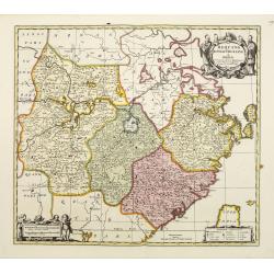
Royaume de Prusse et Prusse Rle. ou Polonoise.
On the left is Pomerania and the Desert of Waldow. At the top of the map is Memel and Samland. On the right side is the Biss River and Kautten. In the center of the map i...
- $125 / ≈ €110
Place & Date: Paris, later than 1749

Comté d'Hollande, seigneurie d'Utrecht, comtés de Zelande, de Zutphen et duché de Brabant &c. Dressés sur les Mémoires faits par ordre des Estats Généraux et augmentés sur les Observations nouvelles.
Pocket atlas illustrated with a folded engraved title, a general map and 34 folded maps, including maps of the Netherlands, Belgium and parts of Germany.Provenance : Ex-l...
- $2400 / ≈ €2114
Place & Date: Paris, Crépy, ca. 1748
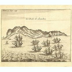
La rade d'Annobon.
Fine print of the arrival of the Dutch fleet by Cornelis Matelief de Jonge at Annobon, September 7th 1605. Cornelis Matelief de Jonge made a trip for the V.O.C. to the Ea...
- $100 / ≈ €88
Place & Date: Amsterdam, J.F. Bernard, 1725
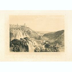
Cascatelles à Tivoli.
Uncommon and decorative lithography of the waterfalls near Tivoli.Published by Carl Johan Billmark and printed by Lemercier in Paris, 55 rue de Seine, the leading firm in...
- $100 / ≈ €88
Place & Date: Paris, c.1859
Rom: Keyserl. Majest. Königl Hoher Allierten Kriegs Theatrum von Schlesien, Böhmen, Maehren u: Oestereich. . .
A rare map centred on Austria, eastern Germany, Poland and Tsjechië. In upper right corner an inset plan of Prague. Showing the situation of the first Silesian War of 17...
- $900 / ≈ €793
Place & Date: Nuremberg, 1742
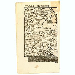
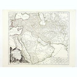
(Central Europe)
Map showing the region between the Black Sea and the Caspian Sea with parts of Tartary and Kazakhstan, also the neighboring Armenia in the south.From a German text editio...
Place & Date: Basle, 1550-1590
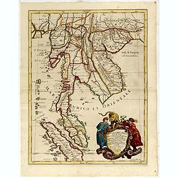
Penisola Dell India di la dal Gange Diusa ne i Regni, che in essasi contengono et accresciuta di varie notizie. Da Giacomo Cantelli da Vignola e conforme le Relationi di alcuni Padri della Compa di Giesu di Monsu Tavernier . . . 1683
Giacomo Rossi's fine late 17th century map of Malaysia, Thailand, Cambodia and part of Sumatra.. Engraved by Franciscus Donia. Issued in Il Mercurio geografico In lower r...
Place & Date: Rome, 1683-1688
![Mayence Mentz en allemand .. [Metz]](/uploads/cache/13109-250x250.jpg)
Mayence Mentz en allemand .. [Metz]
A very RARE panoramic view of the city of Metz, including a numbered legend in the lower corners. The plate is numbered in red pencil in the upper right corner.Engraved b...
- $200 / ≈ €176
Place & Date: Paris 1690-1720
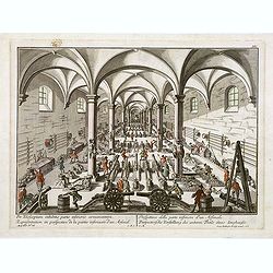
Per telecopium exhibitio partis inferioris armamentarii. / Representation en perspective de la partie inferieure d'un arsenal. . .
RARE. Engraved optical print by Georg Balthasar Probst of a arsenal.
Place & Date: Augsburg, 1750

Missions et Résidences dans la Partie Septentrionale de l'Amérique Contenant 50 Jésuites.
Very rare missionary map of North America from "Atlas Universel indiquant les établissemens des Jésuites: avec la manière dont ils divisent la terre, suivi desév...
- $300 / ≈ €264
Place & Date: Paris, Ambroise Dupont , 1826
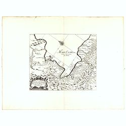
Vera Delineatio Provinciae Fertilissimae Kilan olim Hyrcaniae ad Mare Caspium Sitae.
Uncommon map prepared by Adam Olearius showing the region of Azerbaijan and Iran. The map is oriented with north to the upper left corner and adorned with an attractive t...
- $400 / ≈ €352
Place & Date: Jean Dupuis in Paris, 1659
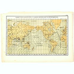
Kaart der Isorachiën of Lijnen van Gelijke Vloedbeweging.
One of the earliest thematic world maps published in the Netherlands from "Atlas der natuurkundige aardrijkskunde. . .". prepared by Nicolaas Wilhelmus Posthumu...
- $35 / ≈ €31
Place & Date: Amsterdam, C.L. Brinkman, 1883

Moscovia o Russia.
Map showing European Russia and is centered on Moscow. In the lower right corner, title cartouche with scale and the town of Astrakhan. From "Atlante Novissimo Che C...
Place & Date: Venice, 1740

Die Spanier streiten mit den Indianern welche ihre Wohnung auff den Bäumen haben.
Native Americans in trees drop stones, shoot with arrows, and pour water on Spanish soldiers who attack from the ground. One man chops at a tree trunk while two others ho...
- $150 / ≈ €132
Place & Date: Frankfurt, 1607

Gouvernements de Berri, du Nivernois,de la Marche, Limousin..
Detailed map encompassing Berri, Nivernois, Limousin and Auvergne.Venetian edition of the map by Bonne, to whom Santini gives credit in the cartouche.From "Atlas Uni...
- $75 / ≈ €66
Place & Date: Venice, 1776 - 1784
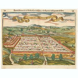
Il Cuscho citta principale della provincia del Peru.
A very desirable and scarce item of this decorative and early bid's-eye town-plan of the Inca city of Cuzco. Several figures shown inside the city walls and on the hillsi...
Place & Date: Lyons, 1564
![[Lot of 6 plates] Carte de la Laponie Suedoise.](/uploads/cache/36604-250x250.jpg)
[Lot of 6 plates] Carte de la Laponie Suedoise.
Chatelain's map of Lapland (170 x 205mm.) , with views of indigenous people and customs (including Reindeer!), etc.Together with 4 other engraved pages with views of indi...
- $300 / ≈ €264
Place & Date: Amsterdam, 1719
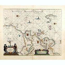
Pascaart van Europa alsmede een gedeelte vande Kust van Africa. . .
An eye-catching chart of the entirety of Europe's coastline from northern Russia to Yugoslavia in the south. Also showing the West Coast of Africa as far as the Cape-Verd...
Place & Date: Amsterdam, after 1666
Selling price: $2375
Sold in 2023
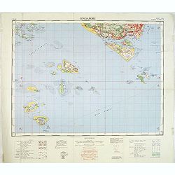
Singapore. - Sheet 134h Keppel harbour.
Map of Singapore. Map with legend and scale. According to a note "Prepared under the direction of the Surveyor General Malaya from the following sources materials : ...
- $750 / ≈ €661
Place & Date: Kuala Lumpur, 1958

Wie ist das gluck so gar ungleich . . . Plate 18.
Early print showing a hanging in Brabant on 11 February 1620.Plate from the series about the " Eighty Years' War" or the independence war of Holland against Spa...
- $80 / ≈ €70
Place & Date: Cologne, ca. 1590

t'Oost-Indisch-Huys.
A decorative print of the East Indian House, the headquarters of the V.O.C., a place for meeting, trading and storage of spices and ship equipment. The maps and charts we...
- $150 / ≈ €132
Place & Date: Amsterdam, 1760-1767

Ingermanlandiae seu Ingriae novissima tabula luci tradita. . .
Detailed map centered on St. Petersburg. With imposing title cartouche and panoramic view of St. Petersburg. The map was drawn shortly after the conclusion of the Great N...
- $950 / ≈ €837
Place & Date: Nurenberg, 1780

A View of the celebrated Great Wall of China which divides that Empire from Tartary...
A decorative copperplate print of festivities being held at the Great wall in China. The scene is framed within an ornately decorative border. Engraved for Millar's 'New ...
Place & Date: London, ca. 1782
Selling price: $25
Sold in 2021

Asia recens Summa cura delineata.
Very rare map of Asia separately published. Derivative map by Picart of Hondius' rare separately issued map of 1618, with the lower panels removed. Surrounded with three ...
Place & Date: Paris, 1644
Selling price: $3000
Sold in 2023
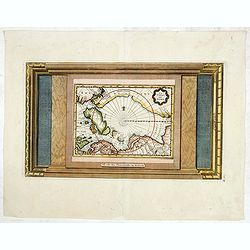
La Terre du Nord.
Map of the Arctic Circle, set within a series of decorative borders, printed from a different copper plate. All counties that lie within or near to the North Pole are sho...
- $1000 / ≈ €881
Place & Date: Amsterdam, 1713
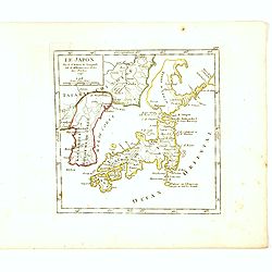
Le Japon Par le Sr. Robert de Vaugondy fils de Mr. Robert Geog. Ord du Roi avec Privilege 1749.
Small detailed map of Japan and Korea. From Atlas Portatif Universel, by Robert de Vaugondy.Page 168 outside border top right. First state. The map is of interest for the...
- $220 / ≈ €194
Place & Date: Paris, 1749
![[Title page] Thesauri Philo-Politci Pars Sexta. . .](/uploads/cache/35638-250x250.jpg)
[Title page] Thesauri Philo-Politci Pars Sexta. . .
Very skillfully engraved title page from a rare work printed by Eberhard Kieser: Thesaurus Philo-Politicus. Das ist Politisches Schatzkästlein guter Herren und bestendig...
- $90 / ≈ €79
Place & Date: Frankfurt, 1625
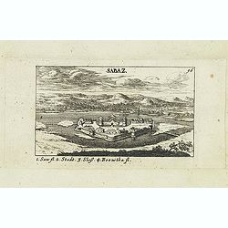
Sabaz. (Sabac)
View of Šabac in western Serbia, along the Sava river.Published in "Der Donau-Strand Mit allen seinen Ein- und Zuflüssen. . .". Published by Jacob Sandrart.
- $75 / ≈ €66
Place & Date: Nuremberg, Jacob Sandrart, 1684
Novus XVII Inferioris Germaniae Provinciarum Typus.
Willem Blaeu published this map in 1608 as a wall map with figured borders. When later, in 1630 he needed a general map of the Netherlands for his first atlas, the Append...
Place & Date: Amsterdam, 1634

Leaf on vellum from a manuscript Book of Hours.
14 Lines of text in Latin and three 1-line initials in blue on colored grounds.RECTO: 14 Lines of text in Latin and three 1-line initials in blue on colored grounds with ...
Place & Date: France, ca.1470

FEMME DE NAZARETH (Palestine). Costumes Syriens 10.
A beautiful hand colored lithograph of a woman from Nazareth (Palestine) published in the French work "Galerie Royale de Costumes peints d´après nature par divers ...
- $300 / ≈ €264
Place & Date: Paris, Chez Aubert & Cie., 1842-1848

Leaf on vellum from a manuscript Book of Hours.
14 Lines of text in Latin and three 1-line initials in blue on colored grounds.RECTO: 14 Lines of text in Latin and four 1-line initials in blue on colored grounds with l...
Place & Date: France, ca.1470
Die Insel Formosa neu abgemessen auf Befehl Kaysers Kamhi.
One of the earliest obtainable printed maps of Taiwan or Formosa Island. It was issued around 1726 to illustrate Joseph Stöcklein's [Stoecklein] compellation of Jesuit m...
Place & Date: Augsburg, 1726
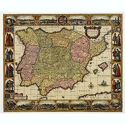
Nova et accurata Tabula Hispaniae. . .
Second state. The map shows the geographical image introduced by Hessel Gerritsz's 1612 wall map of Spain, based on information provided by the Coimbra University profess...
Place & Date: Amsterdam, 1633
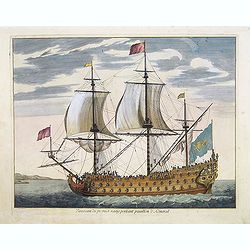
Vaisseau du premier rang portant pavillon d'amiral.
Fine double-page engraved plate of a naval vessel, with the various parts of the ship numbered and identified. From Mortier's "Neptune François". From Mortier'...
Place & Date: Amsterdam, 1695

Paris fashion plate. (164)
From Revue de la Mode. Gazette de la Famille.. Underneath the print are the names of the shops where the clothing's, perfumes, porcelains, flowers, etc., depicted in the ...
Place & Date: Paris, 1875
Selling price: $30
Sold in 2011

Hispaniae Antiquae Tabula.
A fine map of ancient Spain, Portugal and Majorca, etc.This edition carries the date 1641 and in manuscript pencil 1690.Nicolas Sanson was to bring about the rise of Fren...
- $200 / ≈ €176
Place & Date: Paris, 1641-1690
Dongerdeel.. De vierde grietenij van Ooster Goo.
Very decorative map centered on Dokkum, Metzerwier, and Pasens from the Uitbeelding der Heerlijkheit Friesland prepared by Schotanus. With decorative title cartouche lowe...
Place & Date: Leeuwarden, F.Halma, 1718
![Teatro Belgico. [Title page ]](/uploads/cache/13992-250x250.jpg)
Teatro Belgico. [Title page ]
Rare tile page from Teatro Belgico, showing an allegory surrounded by court members: on the lower part, seven coats of arm from the Dutch northern provinces.
- $200 / ≈ €176
Place & Date: Amsterdam, 1690
![Schat-Kamer ofte konst der stuurlieden, inhoudende Een duidelyke onderwyzinge in de navigatie. . . [bound with] Geographische Tadfel vande Graaden.. Voornaamste Zee-haavens. . .](/uploads/cache/33114-250x250.jpg)
Schat-Kamer ofte konst der stuurlieden, inhoudende Een duidelyke onderwyzinge in de navigatie. . . [bound with] Geographische Tadfel vande Graaden.. Voornaamste Zee-haavens. . .
Rare and important manual originally prepared by Klaas de Vries and improved by Evert Floryn and S.Hollander of the "Schat-Kamer ofte konst der stuurlieden" (Tr...
Place & Date: Amsterdam, Wed. Gerard Hulst van Keulen, 1802
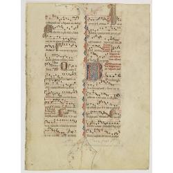
Leaf on vellum from an antiphonary.
A more than 600 years old antiphonary leaf, written in Besançon, in 1370. Musical notation on 4 bars, the staves are in red and the notes in black: numerous pen-flourish...
Place & Date: France, 1370
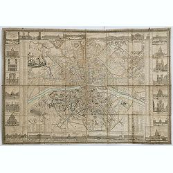
Nouveau Plan Routier de la Ville et Faubourgs de Paris // Avec ses principaux Edifices et Nouvelles Barrieres.
Decorative wall map of Paris, published by M. P|chon in Paris and engraved by Michel Glot. The plan is framed by a floral border and there are 27 Parisian views of places...
Place & Date: Paris, 1834
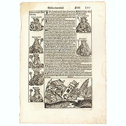
Quinta Etas Mudi. Folium. LXV (With view of Babylon)
The Latin text page is illustrated with an imaginary of the Ancient City of Babylon (Dim. H : 138 mm W : 223 mm).Babylon was the capital of Babylonia, the alluvial plain...
- $150 / ≈ €132
Place & Date: Nuremberg, 12 July 1493
![[Text page with imaginary towns in Westphalia and Hesse. CCLXXXIIII ].](/uploads/cache/37487-250x250.jpg)
[Text page with imaginary towns in Westphalia and Hesse. CCLXXXIIII ].
On recto, an imaginary view of towns in Westphalia (230x225mm.). Verso of towns in the province Hesse.Page from the richest illustrated Incunabula, the famous: Nuremberg ...
- $200 / ≈ €176
Place & Date: Nuremberg, 12 July 1493
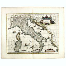
Nova Italiae delineatio.
Originally engraved for Jodocus Hondius II, at his death in August 1629 this map was, among other copper plates,purchased by Willem Blaeu who trimmed the figured borders,...
Place & Date: Amsterdam, 1638
![ISLA DE CUBA [with 2 maps] Plano Pintoresco De La Habana con los numeros de las casas B. May y Ca. 1853. (with) Inset map Puerto y Cereanias De La Habana. (with) 14 views of Havana & prominent buildings.](/uploads/cache/36720-250x250.jpg)
ISLA DE CUBA [with 2 maps] Plano Pintoresco De La Habana con los numeros de las casas B. May y Ca. 1853. (with) Inset map Puerto y Cereanias De La Habana. (with) 14 views of Havana & prominent buildings.
Lithographic town-plan surrounded with views of the city of Havana including the "Fuente De La India En El Paseo De Isabel 2a." and "Vista Gral De La Haban...
Place & Date: Havana, 1853
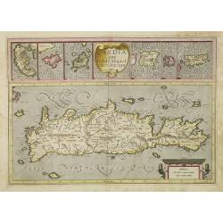
Candia cum Insulis.. Corfu Zante, Milo, Nicsia, Santorini.
Four views on one sheet: A large map of Crete, with three smaller views across the top showing the Ionian Islands of Kerkira (Corfu), Cephalonia and Zakinthos (Zante.) Th...
Place & Date: Amsterdam, 1630
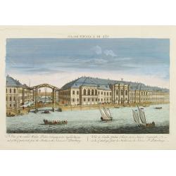
Vuë de l'ancien Palais d'hiver de sa Majesté Imperiale et du Canal qui Joint la Moika avec la Neva, a St. Petersburg.
So-called optical print illustrating a perspective view of St. Petersburg, namely the ancient Winter Palace and the canal which joins the Moika to the Neva.In the eightee...
Place & Date: Paris, 1760

Amérique Septentrionale .. Les Etats Unis..
Very rare state: probably separately issued. Published the same year the Treaty of Paris was signed, this is one of the first maps to provide printed boundary lines for t...
- $3000 / ≈ €2643
Place & Date: Paris, 1786

Systémes Planétaires
A charming print showing an armillary globe with smaller circular diagrams illustrating the theories of Ptolemy, Copernicus, Brahe, etc. Published by Alexandre Emile Lapi...
- $150 / ≈ €132
Place & Date: Paris, 1830

Carte de la Côte de Guzerat, Du Golf de Cambaye et des Côtes de Concan et De Canara.
French sea chart of West India from Gujarat to Mangalore. With inset chart Plan de la Rivière de Surate.Prepared by Jacques-François L'Abbé Dicquemare (1733-1789). La...
Place & Date: Paris, ca 1775

Vue d'un Feu d'Artifice tiré devant l'Hotel de Ville en réjouissance de la Paix.
Optical view, illustrating a fireworks display in front of the Paris city hall.In the eighteenth and nineteenth centuries there were many popular speciality establishment...
Place & Date: Paris 1760

Paskaart der Zeekusten van Italien Tusschen Piombino en C. dell Arme Met de Noord-kust van 't Eylandt Sicilia..
Centered off the Ponziane Islands, this sea chart covers the area of the Tyrrhenian Sea, delimited by Sardinia, the Elba island, the Strait of Messina and Trapani. It con...
- $1000 / ≈ €881
Place & Date: Amsterdam, 1708
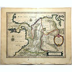
Terra Firma et Novum Regnum Granatense et Popayan.
A handsome map of modern-day Panama and Colombia. The cartouches and decoration are colored in an artistic way. Very fine and rare with this type of coloring.From "l...
Place & Date: Amsterdam, 1635-1638
Etats du Grand-Seigneur en Asie, empire de Perse, pays des Usbecs, Arabie et Egypte.
Detailed map of the region bounded by the Black Sea, Georgia, the Caspian, Uzbekistan, The Indian Ocean, Saudi Arabia (here called \"Arabie Heureuse\"), Egypt a...
Place & Date: Venise, 1778
Huquang, Kiangsi, Chekiang ac Fokien.
A reissue of Janssonius' map of south east China, with wash color and uncolored cartouches.The map is based on the maps of Martin Martini, themselves based on Chinese sou...
Place & Date: Amsterdam, 1720
Vue perspective de la Place des Peintres ditte Perlach du cote de la Basse Ville a Prague.
A so-called optical print of a square in Prague by Basset, a well-known publisher of optical prints, was established in rue S.Jacques in Paris. With brief key list.In the...
- $300 / ≈ €264
Place & Date: Paris, 1760
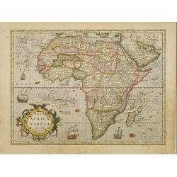
Nova Africae Tabula.
An attractive map of the continent, added by Hondius when he took over publication of Mercator's Atlas. Although it is based on Mercator's map, Hondius improved the outli...
Place & Date: Amsterdam, 1630

Carte des Pays voisins de la Mer Caspiene. . .
A most attractive and detailed map of the region between the Black and Caspian Seas after De L'Isle. The two Seas are decorated with compass roses. This is one of the few...
Place & Date: Amsterdam, 1720
Amérique..
Very detailed map from Atlas Sphéroïdal & Universel de géographie. Prepared by F.A.Garnier and edited by Jules Renouard, rue de Tournon, Paris. With decorative tit...
- $175 / ≈ €154
Place & Date: Paris, 1861
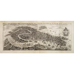
Desciption de lopulente et manifique ville de Venise.
Extremely rare panoramic view of Venice and neighboring islands (Murano, Burano, Torcello and Mazorbo), clearly depicting the city's architectural landmark. The surroundi...
Place & Date: Paris, 1646
Kom - Kaschan.
An early of Kom and Kaschan on one sheet. From the rare first edition "Offt begehrte Beschreibung der newen orientalischen Rejse, so durch Gelegenheit einer Holstei...
- $250 / ≈ €220
Place & Date: Schleßwig, Zur Glocken, 1647
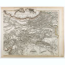
Specialkarte der Asiatischen Turkey : 1. Blatt Anadoli (Klein - Asien)
Steel engraved map of western part of Turkey, engraved by Ifslieb and J. Grassl.
- $75 / ≈ €66
Place & Date: Hildburghausen, 1860
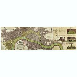
Urbium Londini et West-Monasterii nec non Surburbii Southwark Accurata Ichnographia ,., Neuester Grundris der Staedte London und West-Munster, Samt der Vorstadt Southwark ,.,
Detailed plan of London, extending from Grosvenor Square in the west to Mile End to the east, To the right inset views of St, James's Square, and Custom House, elevations...
Place & Date: Nuremberg, 1736
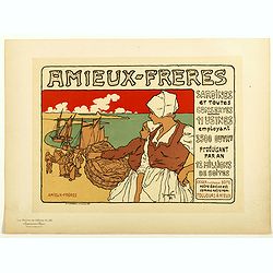
Amieux Freres, sardines et toute conserves.
Chromo lithographed poster of Les Maîtres de l'Affiche being plate n°183. The "Les Maîtres de l'Affiche" contained 256 small for lithographic prints of the b...
Place & Date: Paris, Imprimerie Chaix, 1899

Colomna - Cassimogorod - Moruma.
Three panoramic views of Colomna - Cassimogorod - Moruma on one sheet. From the rare first edition "Offt begehrte Beschreibung der newen orientalischen Rejse, so dur...
- $300 / ≈ €264
Place & Date: Schleßwig, Zur Glocken, 1647

Le vray portraict de la Ville de Marseille.
Fine wood cut bird's-eye view of Marseille. Decorated with several ship in the harbour and on the sea. To the left two keys describing the main buildings and places. Publ...
Place & Date: Paris, 1575
Plan de la ville de Louvo . . .
Early plan of Louvo city. Across the top is an extensive list of 22 important sites and locations keyed to the plan with tiny letters and numbers.Jacques Nicolas Bellin (...
Place & Date: Paris, 1750
![Voyage de la Fregate la Venus. . . [Planche 16].](/uploads/cache/14133-250x250.jpg)
Voyage de la Fregate la Venus. . . [Planche 16].
An attractive collection of shells. From Jules-Sébastien-César Dumont d'Urville (1790-1842) Voyage au Pole Sud et dans l'Océanie sur les Corvettes L'Astrolabe et la Z�...
- $150 / ≈ €132
Place & Date: Paris, 1833

Vue & description de l'Eglise du Saint Sepulchre tant par dehors que dedans . . .
Shows various interiors and exterior views of the Church of the Holy Sepulcher in Jerusalem. From Chatelain's monumental 7 volume "Atlas Historique".Henri Abrah...
Place & Date: Amsterdam, 1720