Moscovia Sigismundi Liberi Baronis In Herberstein, Neiperg et Gutehnag Anno M.D XLIX |
||||||||||||||||||||
|
||||||||||||||||||||
|
|
||||||||||||||||||||
This item is available for immediate sale
Feel free to contact us if you have a question about this item.
Or do you like to be notified about newly added items? Add your name to our mailing list.
3000.00
|
||||||||||||||||||||
Description
Sigismund von Herberstein made two visits to Russia. In 1517-18 he travelled as a diplomatic envoy of the Holy Roman Emperor, Maximilian I. He returned in 1526-27 as an ambassador of Ferdinand I, King of Bohemia and Hungary. His combined visits amounted to a period of sixteen months during which he was able to see "... the land and city of Moscow and much of their manners and customs... Thus I can bear witness not merely from hearsay but as one who has seen partly for himself..." (Translation by J B C Grundy: 1969, p15)
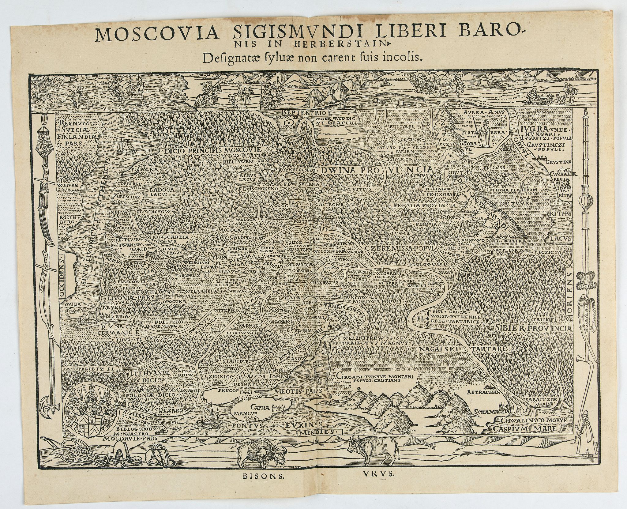
One of two maps of Russia compiled by Herberstein, who was ambassador from the Habsburg Emperor, Maximilian I to Moscow. Herberstein's important early map of Russia, from a German edition of Sigismund Herberstein's Moscoviter Wunderbare Historien, first published in Basel in 1563. Herberstein's work including 3 maps, the first modern plan of Moscow and two maps of Muscovy, one topographical and one including physical features.
The maps are likely In his work on the early cartography of Russia, Leo Bagrow notes: Heberstein was twice at Moscow-in 1517 and 1526. Herberstein's knowledge of a Slavonic language facilitated his intercourse with local inhabitants on his travels in Russia, and his academic education gave him a desire for knowledge of a country so little known to Western Europe. He missed no opportunity to question the people he met, not only on the customs and government of the country, but also on its geography, and particularly that of the border regions. He verified the information he collected by cross-questioning different persons on the same subject, and he also tried to obtain various written documents and records of itineraries. He attempted to procure maps too, but as these, besides being very scarce, were kept strictly secret by the authorities, he tried to persuade those whose knowledge he could trust to prepare maps for him. According to Lyatsky, who however made this statement after having left Russia, he had asked him to compile a map but met with a refusal. Herberstein does not tell us whether he succeeded in obtaining cartographic materials from any other person. But he certainly obtained plenty of oral information and some graphic material too.
Thus we know that Grigoryi Istome and Vlasiy and Dmitriy Gerasimov, separately, described to him the navigation from the mouth of the North - Dvina, round Scandinavia, to Denmark. Somebody else gave him a travelling guide from the Dvina to the Ob'. By the time he came to Moscow this route was already fairly well known: in 1491 Andrey Petrov and Vasiliy Ivanov Boltin were despatched to the Pechora in quest of silver ore; in 1499 Prince Kurbskiy led an expedition to the Yugor region and crossed the Ural. Herberstein reprinted the traveling guide to the Pechora and the Ob', and we know that it already contained information on the town of Kumbalik, i.e. Pekin. The reference to a sea-route by the north coast of Europe and Asia to China made by Paolo Giovio, following Gerasimov, suggests that Herberstein had also been told about this route at Moscow. About the campaign against the Kazan' Tartars in 1524 Herberstein had heard direct from one of its participants, Voevoda S. Chelyadin, whom he had met earlier (1514) at Vilna, where Chelyadin was living as a prisoner of war after the battle at Orsha. Herberstein helped and comforted him at that time and gave him 20 ducats.
At last, in the 1540's, Herberstein began to sort the materials he had collected and to write up his Notes. The first edition of his Rerum Moscovitarum comentarii, containing a copper-engraved map, appeared at Vienna in 1549. This map however was preceded by another, with the same title, which had been engraved by Hirsvogel three years earlier. . . .But this map was of larger format (560 x 358 mm.) and would have had to be folded to fit the book. This presumably explains the production of a second map in reduced size (261 x 160 mm.). There are practically no alterations in this second map, save the omission or addition of a few names. The only notable alteration is the introduction of the Solovki. Comparing the two with each other or with later issues, we must bear in mind that the repetition of an engraving by different masters is naturally not merely a reproduction or a copy of the original-certain divergencies in the disposition of the names and their writing will always occur, especially if the map has been re-engraved for a new publisher, or in a different language. Sigismund Herberstein was Emperor Maxmillian I's ambassador to Russia, who made two official trips to Moscow.
Herberstein was born in 1486, in what is now Slovenia, and was then part of the Holy Roman Empire. He was knighted by Maximilian I in 1514, received his first diplomatic appointment in 1515 and undertook many more missions during the following thirty-eight years. Aside from his visits to Russia, he went to Switzerland, Denmark, Spain, Poland, Bohemia and Hungary. His work frequently involved arduous and dangerous journeys. In all, between 1515 and 1553, Herberstein participated in 69 foreign missions, which traveled throughout much of Europe, including Turkey. During his travels in Russia, he made extensive observations. Herberstein was able to communicate freely with the Russians because of their knowledge of Slovenian and Slovenian as both the Russian belong to the Slavic languages. Herberstein used this knowledge to ask a variety of people in Russia on various topics, which gave him a vision of Russia and the Russians which surpassed prior visitors.
It is likely that he wrote his first report about life in Russia between 1517 and 1527, but the text has not survived to this day. In 1526 was asked to write a formal report on his experiences in Russia, but it remained relatively unnoticed in the archives until he could find time to revise and expand it. The result was his greatest work, a book written in Latin under the title Commentarii Rerum Moscoviticarum (literally Comments on Muscovite Affairs), published in 1549. This book became the main source of knowledge about Russia in Western Europe.
Siegmund (Sigismund) Freiherr (Baron) von Herberstein is most noted for his extensive writing on the geography, history and customs of Russia and contributed greatly to early Western European knowledge of that area.
As the foremost diplomat for the Holy Roman Empire, between 1515 and 1553, Herberstein carried out approximately 69 missions abroad, travelling throughout much of Europe, including Turkey. He was feted by the ruling Habsburgs and rewarded with titles and estates.
He was Emperor Maxmillian I's official ambassador of the Holy Roman Empire to Russia. He made two official trips to Moscowin, in 1517 to attempt to arrange a truce between Russia and Lithuania, and in 1526 to renew a treaty between the two signed in 1522. These extended visits (nine months in his 1517 visit) provided him with the opportunity to study a hitherto largely unknown Russian geography and Russian society.
Herberstein's knowledge of Slovene, acquired in his youth, allowed him to communicate freely with Russians, as Slovene and Russian both belong to the Slavic languages.
Between 1515 and 1553, Herberstein carried out approximately 69 diplomatic missions abroad, travelling throughout much of Europe, including Turkey. He was feted by the ruling Habsburgs and rewarded with titles and estates.
"Heberstein was twice at Moscow in 1517 and 1526. Herberstein's knowledge of a Slavonic language facilitated his intercourse with local inhabitants on his travels in Russia, and his academic education gave him a desire for knowledge of a country so little known to Western Europe. He missed no opportunity to question the people he met, not only on the customs and government of the country but also on its geography, and particularly that of the border regions. He verified the information he collected by cross-questioning different persons on the same subject, and he also tried to obtain various written documents and records of itineraries. He attempted to procure maps too, but as these, besides being very scarce, were kept strictly secret by the authorities, he tried to persuade those whose knowledge he could trust to prepare maps for him. According to Lyatsky, who, however, made this statement after having left Russia, he had asked him to compile a map but met with a refusal.
Herberstein does not tell us whether he succeeded in obtaining cartographic materials from any other person. But he certainly obtained plenty of oral information and some graphic material too. Thus we know that Grigoryi Istome and Vlasiy and Dmitriy Gerasimov, separately, described to him the navigation from the mouth of the North - Dvina, around Scandinavia, to Denmark. Somebody else gave him a traveling guide from the Dvina to the Ob'. By the time he came to Moscow, this route was already fairly well known: in 1491 Andrey Petrov and Vasiliy Ivanov Boltin were despatched to the Pechora in quest of silver ore; in 1499 Prince Kurbskiy led an expedition to the Yugor region and crossed the Ural.
Herberstein reprinted the traveling guide to the Pechora and the Ob', and we know that it already contained information on the town of Kumbalik, i.e. Pekin. The reference to a sea-route by the north coast of Europe and Asia to China made by Paolo Giovio, following Gerasimov, suggests that Herberstein had also been told about this route at Moscow. About the campaign against the Kazan' Tartars in 1524 Herberstein had heard direct from one of its participants, Voevoda S. Chelyadin, whom he had met earlier (1514) at Vilna, where Chelyadin was living as a prisoner of war after the battle at Orsha. Herberstein helped and comforted him at that time and gave him 20 ducats.
At last, in the 1540's, Herberstein began to sort the materials he had collected and to write up his Notes. The first edition of his Rerum Moscovitarum comentarii, containing a copper-engraved map, appeared at Vienna in 1549. This map however was preceded by another with the same title, which had been engraved by Hirsvogel three years earlier. But this map was of larger format (560 x 358 mm.) and would have had to be folded to fit the book. This presumably explains the production of a second map in reduced size (261 x 160 mm.). There are practically no alterations in this second map, save the omission or addition of a few names. The only notable alteration is the introduction of the Solovki. Comparing the two with each other or with later issues, we must bear in mind that the repetition of an engraving by different masters is naturally not merely a reproduction or a copy of the original-certain divergencies in the disposition of the names and their writing will always occur, especially if the map has been re-engraved for a new publisher, or in a different language."

FAQ - Guarantee - Shipping
Buying in the BuyNow Gallery
This item is available for immediate purchase when a "Add to Cart" or "Inquire Now" button is shown.
Items are sold in the EU margin scheme
Payments are accepted in Euros or US Dollars.
Authenticity Guarantee
 We provide professional descriptions, condition report and HiBCoR rating (based on 45 years experience in the map business)
We fully guarantee the authenticity of items we sell. We provide a certificate of authenticity for each purchased item.
Condition / Coloring
We indicate the condition of each item and use our unnique HiBCoR grading system in which four key items determine a map's value: Historical Importance, Beauty, Condition/Coloring and Rarity.
We offer many maps in their original black and white condition. We do not systematically color-up maps to make them more sellable to the general public or buyer.
Copper engraved or wood block maps are always hand colored. Maps were initially colored for aesthetic reasons and to improve readability. Nowadays, it is becoming a challenge to find maps in their original colors and are therefor more valuable.
We use the following color keys in our catalog:
Original colors; mean that the colors have been applied around the time the map was issued.
Colored; If the colors are applied recently or at the end of the 20th century, then "colored", or "attractive colors" will be used.
Original o/l colors; means the map has only the borders colored at the time of publication.
Read more about coloring of maps [+]
FAQ
Please have a look for more information about buying in the BuyNow gallery.
Many answers are likely to find in the general help section.
Virtual Collection
![]()
With Virtual Collection you can collect all your favorite items in one place. It is free, and anyone can create his or her Virtual map collection.
Unless you are logged in, the item is only saved for this session. You have to be registed and logged-in if you want to save this item permanently to your Virtual Collection.
Read More [+]
Registering Here, it is and you do not need a credit card.
Add this item to
Virtual Collection
or click the following link to see my Virtual Collection.
Invoice
The invoice and certificates of authenticity are available in the client center >Invoices
| High-Resolution Digital Image Download | |
|
Paulus Swaen maintains an archive of most of our high-resolution rare maps, prints, posters and medieval manuscript scans. We make them freely available for download and study. Read more about free image download |
Click this image for a free HR-image download. |
In accordance with the EU Consumer Rights Directive and habitually reside in the European Union you have the right to cancel the contract for the purchase of a lot, without giving any reason.
The cancellation period will expire 14 calendar days from the day after the date on which you or a third party (other than the carrier and indicated by you) acquires, physical possession of the lot. To exercise the right to cancel you must inform Paulus Swaen Europe bv, which is offering to sell the lot either as an agent for the seller or as the owner of the lot, of your decision to cancel this contract by a clear statement (e.g. a letter sent by post, or e-mail (amsterdam@swaen.com).
To meet the cancellation deadline, it is sufficient for you to send your communication concerning your exercise of the right to cancel before the cancellation period has expired.