Subscribe to be notified if similar examples become available.
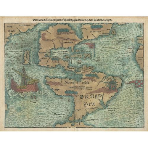
Die Neuwen Inseln so Hinder Hispanien Gegen Orient bey dem Land Indie Ligen |
||||||||||||||||||||
|
||||||||||||||||||||
|
|
||||||||||||||||||||
|
Selling price: $4500
Sold in 2023 Missed this item! Be the first to get notified about our newly added listings. Add your name to our mailing list. |
||||||||||||||||||||
Description
This is an authentic, antique map of the Western Hemisphere showing North and South America connected as true continents. It is the 5th state example published out of Basel as part of Sebastian Munster’s Geographia in 1550.
Munster’s map of the Western Hemisphere is the earliest known map to focus on all of America and the first to officially name the Pacific Ocean “Mare Pacificum.” North America is shown nearly bisected by the Sea of Verrazzano, which was the result of Verrazzano mistaking the waters west of the Outer Banks along North Carolina as the Pacific Ocean. The earliest appearance of Japan (Zipangri) shows the island positioned just west of North America with an archipelago and Pacific Ocean whose size is severely underestimated. The Yucatan Peninsula is depicted as an island (Iukatana) and Puerto Rico (named Sciana) is marked with the Castile and Leon flag of Spain.
South America displays a large western and eastern bulge, in which Cannibals are noted with a vignette of a severed limb outside of some bushes. Cannibals would be noted in the area of Brazil for well over 100 years after this map was published. A very early appearance of the Strait of Magellan is noted between the southern tip of South America and a large landmass (Tierra del Fuego), which for about 80 years after this map would regarded as the great southern continent, commonly labeled “Magallanica or Terra Australis.” In the southern Pacific, a large vignette of Magellan’s Ship floats with sails up.
FAQ - Guarantee - Shipping
Buying in the BuyNow Gallery
This item is available for immediate purchase when a "Add to Cart" or "Inquire Now" button is shown.
Items are sold in the EU margin scheme
Payments are accepted in Euros or US Dollars.
Authenticity Guarantee
 We provide professional descriptions, condition report and HiBCoR rating (based on 45 years experience in the map business)
We fully guarantee the authenticity of items we sell. We provide a certificate of authenticity for each purchased item.
Condition / Coloring
We indicate the condition of each item and use our unnique HiBCoR grading system in which four key items determine a map's value: Historical Importance, Beauty, Condition/Coloring and Rarity.
We offer many maps in their original black and white condition. We do not systematically color-up maps to make them more sellable to the general public or buyer.
Copper engraved or wood block maps are always hand colored. Maps were initially colored for aesthetic reasons and to improve readability. Nowadays, it is becoming a challenge to find maps in their original colors and are therefor more valuable.
We use the following color keys in our catalog:
Original colors; mean that the colors have been applied around the time the map was issued.
Colored; If the colors are applied recently or at the end of the 20th century, then "colored", or "attractive colors" will be used.
Original o/l colors; means the map has only the borders colored at the time of publication.
Read more about coloring of maps [+]
FAQ
Please have a look for more information about buying in the BuyNow gallery.
Many answers are likely to find in the general help section.
Virtual Collection
![]()
With Virtual Collection you can collect all your favorite items in one place. It is free, and anyone can create his or her Virtual map collection.
Unless you are logged in, the item is only saved for this session. You have to be registed and logged-in if you want to save this item permanently to your Virtual Collection.
Read More [+]
Registering Here, it is and you do not need a credit card.
Add this item to
Virtual Collection
or click the following link to see my Virtual Collection.
Invoice
The invoice and certificates of authenticity are available in the client center >Invoices
| High-Resolution Digital Image Download | |
|
Paulus Swaen maintains an archive of most of our high-resolution rare maps, prints, posters and medieval manuscript scans. We make them freely available for download and study. Read more about free image download |
In accordance with the EU Consumer Rights Directive and habitually reside in the European Union you have the right to cancel the contract for the purchase of a lot, without giving any reason.
The cancellation period will expire 14 calendar days from the day after the date on which you or a third party (other than the carrier and indicated by you) acquires, physical possession of the lot. To exercise the right to cancel you must inform Paulus Swaen Europe bv, which is offering to sell the lot either as an agent for the seller or as the owner of the lot, of your decision to cancel this contract by a clear statement (e.g. a letter sent by post, or e-mail (amsterdam@swaen.com).
To meet the cancellation deadline, it is sufficient for you to send your communication concerning your exercise of the right to cancel before the cancellation period has expired.


