Claudii Ptolemaei geographicae enarrationis libri octo Bilibaldo Pirckeym hero interprete Annotationes Ioannis de Regio Monte in errores commissos a Iacobo Angelo in translatione sua. |
||||||||||||||||||||
|
||||||||||||||||||||
|
|
||||||||||||||||||||
This item is available for immediate sale
Feel free to contact us if you have a question about this item.
Or do you like to be notified about newly added items? Add your name to our mailing list.
59000.00
|
||||||||||||||||||||
Description
The 1525 Strassburg edition is the first Ptolemy atlas to name the new continent ‘"America". Fries' map is the first world map in an edition of Ptolemy to include the name America.
The back of map 28, which shows the New World, gives an account of Columbus's discoveries. The maps relating to America are Nos. 28, 34, 49, and 50.
The work is composed of an impressive xylographed title page, large lettering and diagrams, and maps with text on versos enclosed within ornamental borders (said to be after the designs of Hans Holbein the Younger).
Illustrated with 50 double-page maps (except for a single one on the back of a double) including 3 World maps, a map of America, "Oceani Occidentalis seu Terre Nove Tabula" and maps featuring Asia, Africa, Europe, France, Italy, Greece, Crete, the Rhine province, Alsace and Lorraine, England, Spain, etc. The maps are woodcut. The text on the back of the maps is richly illustrated with woodcut culs-de-lampe, vignettes and decorations.
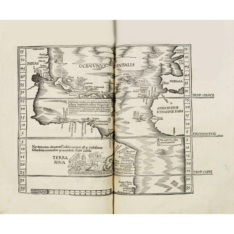
AMERICA : "Oceani Occidentalis seu Terre Nove Tabula" :
« In 1522, Laurent Fries published an edition of Ptolemy’s Geography in which all the maps, including this one, were reduced versions of Waldseemüller’s 1513. Some of the more notable differences are the Columbus name PARIAS found in North America, misplaced from South America, the addition of a Spanish flag over Cuba, and a scene in South America depicting cannibals and an opossum, both of which had been reported by Vespucci. The last map is taken directly from Martin Waldseemüller’s great twelve-sheet Carta Marina of the World, 1516. Here, the TERRA INCOGNITA has also been replaced by TERRA NOVA, and the reference to America’s discovery by Columbus is repeated. A large area of text below Hispaniola describes that island’s location, its discovery by Columbus, and its products. The latitude markings are now corrected and more legible. » (Burden).
Fries' WORLD MAP : "Orbis typus universalis…" :
This world map is an excellent example of the evolving (yet still warped) medieval conception of the world's geography. Fries used Waldseemuller's 1513 edition of Ptolemy's Geographia as the source for most of the maps in his own edition, but this is Fries' own work, and it is even more inaccurate than Waldseemuller's rendering of the modern world. The name America appears for the first time on a Ptolemaic map and is used to identify South America, which occurs with an entirely speculative western coastline. Even relatively well-known areas of the Old World become flawed in Fries' depiction. Scotland and England are separate islands in Europe, and India is split into a double peninsula. Despite these distortions-- or because of them-- this map is much sought after. The map is bordered by a chain of banners naming the winds.
The SECOND MODERN WORLD MAP by Fries : "Tabula Moder. Gronlandiae et Russiae", 1525, reduced from Waldseemüller's map of 1513.
The map is placed at the very end. It is a reduced version of Waldseemüller's map but lacks the crisscross lines. Also, only parts of America are shown at the very west of the map. Fries added five throned effigies of kings, representing those of Russia, Egypt, Ethiopia, Taprobana, and Mursuli. There is also a drawing of an elephant (or perhaps a mammoth) placed just off the coast of Greenland.
PTOLEMAIC WORLD by Laurent Fries after Martin Waldseemüller, 1525 :
This is the first edition of the map with the decorative border, wind heads, and clouds surrounding it. This border is absent in the 1522 edition. The woodcut decorations around the map are attributed to Albrecht Dürer, who also made the famous woodcut print of the armillary sphere in this atlas.
TABULA V ASIAE :
Laurent Fries’ map of Persia is one of the earliest available maps of the region between the Persian Gulf and the Caspian Sea. It shows Babylon and Mesopotamia, what would become Iran and Irak. The ancient Persian capital of Persepolis is identified. In the 1525 edition of Fries, a swimming duck was added to the Caspian Sea.
LAURENT FRIES (c. 1485 – 1532).
L. Fries, a physician, astrologer, and cartographic editor, was a native Alsatian. Nothing is known about his youth and early schooling. His university education in philosophy and medicine has been acquired at several schools. He probably attended Vienna, Montpellier, Piacenza, and Pavia. He obtained a Doctor of Arts degree at one of these institutions.
His first professional position was in Sélestat, near Strasbourg. He practiced medicine in Colmar from 1514 to 1518. He wrote several medical works, including a practice entitled Spiegel der Artzny (Mirror of Medicine), a trendy book with seven editions up to 1546. After 1519, he moved to Strasbourg, where he stayed until about 1527.
In 1520, Fries became involved in publishing new editions of maps by Martin Waldseemüller. He collaborated with Peter Apian to publish a much-reduced version of Waldseemüller's map of 1507.
In the meantime, Fries was preparing a new edition of Ptolemy's Geographia. The book was printed in 1522 by Johannes Grüninger, an esteemed printer from Strasbourg who had previously published the Waldseemüller. It was based on Waldseemüller's editions of 1513 and 1520. Fries says in a note to the reader: "…, we declare that Martin Waldseemüller, piously deceased, originally constructed these maps and that they have been drawn in a format smaller than they ever had". The book sold well, and new editions would follow, printed with the same woodblock.
In 1525, Willibald Pirkheimer, the Nuremberg humanist, published a new edition with Grüninger. The volume was published jointly with the Nuremberg printer Johannes Koberger. It included the same fifty Waldseemüller/Fries maps as the 1522 edition.
Reference: Sabin, 66482 ; Shirley, The Mapping of the World : 47, 48, 49 ; Burden, The Mapping of North America : 4
FAQ - Guarantee - Shipping
Buying in the BuyNow Gallery
This item is available for immediate purchase when a "Add to Cart" or "Inquire Now" button is shown.
Items are sold in the EU margin scheme
Payments are accepted in Euros or US Dollars.
Authenticity Guarantee
 We provide professional descriptions, condition report and HiBCoR rating (based on 45 years experience in the map business)
We fully guarantee the authenticity of items we sell. We provide a certificate of authenticity for each purchased item.
Condition / Coloring
We indicate the condition of each item and use our unnique HiBCoR grading system in which four key items determine a map's value: Historical Importance, Beauty, Condition/Coloring and Rarity.
We offer many maps in their original black and white condition. We do not systematically color-up maps to make them more sellable to the general public or buyer.
Copper engraved or wood block maps are always hand colored. Maps were initially colored for aesthetic reasons and to improve readability. Nowadays, it is becoming a challenge to find maps in their original colors and are therefor more valuable.
We use the following color keys in our catalog:
Original colors; mean that the colors have been applied around the time the map was issued.
Colored; If the colors are applied recently or at the end of the 20th century, then "colored", or "attractive colors" will be used.
Original o/l colors; means the map has only the borders colored at the time of publication.
Read more about coloring of maps [+]
FAQ
Please have a look for more information about buying in the BuyNow gallery.
Many answers are likely to find in the general help section.
Virtual Collection
![]()
With Virtual Collection you can collect all your favorite items in one place. It is free, and anyone can create his or her Virtual map collection.
Unless you are logged in, the item is only saved for this session. You have to be registed and logged-in if you want to save this item permanently to your Virtual Collection.
Read More [+]
Registering Here, it is and you do not need a credit card.
Add this item to
Virtual Collection
or click the following link to see my Virtual Collection.
Invoice
The invoice and certificates of authenticity are available in the client center >Invoices
| High-Resolution Digital Image Download | |
|
Paulus Swaen maintains an archive of most of our high-resolution rare maps, prints, posters and medieval manuscript scans. We make them freely available for download and study. Read more about free image download |
Click this image for a free HR-image download. |

In accordance with the EU Consumer Rights Directive and habitually reside in the European Union you have the right to cancel the contract for the purchase of a lot, without giving any reason.
The cancellation period will expire 14 calendar days from the day after the date on which you or a third party (other than the carrier and indicated by you) acquires, physical possession of the lot. To exercise the right to cancel you must inform Paulus Swaen Europe bv, which is offering to sell the lot either as an agent for the seller or as the owner of the lot, of your decision to cancel this contract by a clear statement (e.g. a letter sent by post, or e-mail (amsterdam@swaen.com).
To meet the cancellation deadline, it is sufficient for you to send your communication concerning your exercise of the right to cancel before the cancellation period has expired.