Browse Listings in America > North America

Prospect von Boston gegen der Bucht am Hafen. / Vue de Boston vers le Cale du Port.
A so-called optical print of a fanciful view of Boston harbour, two ships at anchor, British soldiers and men working, and merchandise on shore; an idealized view depicti...
Date: Augsburg, 1762
Selling price: ????
Please login to see price!
Sold

Travels of the Jesuits...(with Kino map of California).
Famous account by John Lockman, illustrated with five fold-out maps and 1 fold-out plate. With the important "Kino" map of California (Passage by land to Califo...
Date: London, 1762
Selling price: ????
Please login to see price!
Sold in 2015

Vue de la Rue du Roi, vers la Porte de la Campagne a Boston.
A vue d'optique of the city of Boston.
Date: Augsburg, 1762
Selling price: ????
Please login to see price!
Sold in 2018
![L' AMERIQUE SEPTENTRIONALE divisee en les principaux ETATS.[Great western sea, First State]](/uploads/cache/82867-250x250.jpg)
L' AMERIQUE SEPTENTRIONALE divisee en les principaux ETATS.[Great western sea, First State]
First state for this very important map. Engraved by Lattré. This map is most notable for it's depiction of Mer de L'Quest or Sea of the West, near modern-day Seattle. A...
Date: Paris, 1762
Selling price: ????
Please login to see price!
Sold in 2019

Porti della Nuova York e Perthaboy.
"From ""Il Gazettiere Americano"". Engraved by Guseppe M. Terreni. Interesting chart of Manhattan, part of Long Island, New Jersey. Names are in ...
Date: Livorno 1763
Selling price: ????
Please login to see price!
Sold

CARTA RAPPRESENTANTE I CINQUE LAGHI DEL CANADA
Rare and important Italian map showing the area of the Great Lakes. Published in "Il Gazzettiere Americano" 1763. Very detailed map of the area with many place...
Date: Livorno, 1763
Selling price: ????
Please login to see price!
Sold

Carte Générale de l' Amérique Séptentrionale ..
Uncommon 3rd version of Le Rouge's Popple key map by Crepy. This state 3 is a variant of state 2 (from the same plate) except: title at top now states: CARTE GÉNÉRALE D...
Date: Paris, ca. 1763
Selling price: ????
Please login to see price!
Sold

Carta Rappresentante I cinque Laghi del Canada.
Highly detailed map of the Great Lakes and contiguous regions, which appeared in Masi's "Il Gazzettiere Americano." Engraved by A.Scacciati.The map's nomenclatu...
Date: Livorno 1763
Selling price: ????
Please login to see price!
Sold

A New map of North America from the latest discoveries 1763.
From London magazine, January 1763.
Date: London, c.1763
Selling price: ????
Please login to see price!
Sold in 2013

Veduta d'un palco, e della maniera colla quale si pesca acconcia e secca il Baccala in Terra nuova.
This is a view of a cod or fish drying station (stage) in New France or Newfoundland. Includes men fishing for cod, unloading catch from a boat, processing and fileting f...
Date: Livorno, 1763
Selling price: ????
Please login to see price!
Sold in 2015

La caccia dei castori.
Beaver lodge. Includes native Americans hunting beavers using guns or muskets, bows and arrows, waterfall. In the background, hunters skin the beavers.From "Il Gazze...
Date: Livorno, 1763
Selling price: ????
Please login to see price!
Sold in 2015

Figura di un Forte Indiano.
View of a native American settlement or fort. Includes dwellings, domestic animals such as oxen and donkeys, palisades, guns or muskets, and council fire. From "Il G...
Date: Livorno, 1763
Selling price: ????
Please login to see price!
Sold in 2015

A New Map of North America from the Latest Discoveries.
A nice detailed map of the British Colonies in North America, published at the end of the French & Indian War. The claims of the Carolinas, Virginia and New England n...
Date: London, 1763
Selling price: ????
Please login to see price!
Sold in 2020

Cours du Fleuve Saint Louis..
The mouth of the River Mississippi, depths shown by soundings. The only issue of this version of Bellin's map, slightly larger than the standard version. From Bellin's Pe...
Date: Paris 1764
Selling price: ????
Please login to see price!
Sold
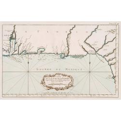
Carte de la coste de la Floride..
Shows the Florida panhandle to Mobile Bay. Little interior data was known. The only issue of this version of Bellin's map, slightly larger than the common version. From B...
Date: Paris 1764
Selling price: ????
Please login to see price!
Sold

La Louisiane et Pays voisins.
The only issue of this version of Bellin's map, slightly larger than the common version. Excellent detail in the Santa Fe area. More than a dozen rivers, many with names ...
Date: Paris 1764
Selling price: ????
Please login to see price!
Sold

Carte de la Virginie Mari-Land &a.
Shows Virginia, Maryland, Delaware, and southern PA & New Jersey. From Bellin's Petit atlas maritime.Tome I N_35.Jacques Nicolas Bellin (1703-1772) was one of the mos...
Date: Paris 1764
Selling price: ????
Please login to see price!
Sold
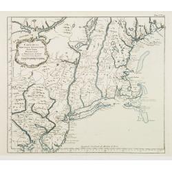
Carte de la Nouvelle Angleterre New York Pensilvanie..
Fine map of New England. From Bellin's Petit atlas maritime.Tome I N_29.Jacques Nicolas Bellin (1703-1772) was one of the most important and proficient French cartographe...
Date: Paris 1764
Selling price: ????
Please login to see price!
Sold

Ville de Manathe ou Nouvelle-Yorc.
This map, which was meant to show New York City, is the printed version of a hand drawn map by J.B.L. Franquelin in 1693.From the Bellin's Petit atlas maritime. In upper ...
Date: Paris 1764
Selling price: ????
Please login to see price!
Sold

Baye et Port d'Yorc Capitale de la Nouvelle Yorc.
A great little map of the entrance of New York Harbour. The city is shown as a tiny village with other settlements including Neversink, Gravesend, Newark, Woodbridge and ...
Date: Paris 1764
Selling price: ????
Please login to see price!
Sold

Plan de Philadelphie et Environs.
Nice early plan of the city of Philadelphia and vicinity depicting roads and scattered farms. Decorative title cartouche and fleur-de-lis. With manuscript reference to an...
Date: Paris 1764
Selling price: ????
Please login to see price!
Sold

Carte de la Louisiane et Pays Voisins.
A very rare map of Louisiana, Texas and central north America, from Le Commerce de l'Amérique par Marseille, ou Explication des Lettres-Patentes du Roi, portant Reglemen...
Date: Avignon 1764
Selling price: ????
Please login to see price!
Sold in 2016
![[Detroit] La Rivière du Détroit Depuis le lac Sainte Claire jusqu'au Lac Erié.](/uploads/cache/17065-250x250.jpg)
[Detroit] La Rivière du Détroit Depuis le lac Sainte Claire jusqu'au Lac Erié.
This is the first separately printed map of Detroit, showing the village, fort, anchorages, islands and navigational hazards, with an inset of the fort with five lettered...
Date: Paris 1764
Selling price: ????
Please login to see price!
Sold

Carte des Cinq Grands Lacs du Canada.
This map shows the territories of all the 5 great lakes. The map shows Indian land, forts, missions, rivers and lakes, plus some trails and portages.The only issue of thi...
Date: Paris 1764
Selling price: ????
Please login to see price!
Sold
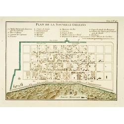
Plan de la Nouvelle Orléans.
A map of New Orleans.The only issue of this version of Bellin\'s map, slightly larger than the common version. Depths shown by soundings.From Bellin\'s Petit atlas mariti...
Date: Paris 1764
Selling price: ????
Please login to see price!
Sold
Embouchures du Fleuve St Louis ou Mississipi.
Shows the Mississippi River where it empties into the Gulf of Mexico.The only issue of this version of Bellin's map, slightly larger than the common version. Depths shown...
Date: Paris 1764
Selling price: ????
Please login to see price!
Sold
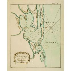
Plan de la Baye de Pensacola dans la Floride.
This chart shows the territories of the inlet of Pensacola in Florida The only issue of this version of Bellin's map, slightly larger than the common version. Depths show...
Date: Paris 1764
Selling price: ????
Please login to see price!
Sold

Port et Ville de Charles-Town dans la Caroline.
This chart shows a block plan of Charleston and the entrance to the harbour where the Cooper and Ashley Rivers meet. Fort Johnson is sketched on the shore at the entrance...
Date: Paris 1764
Selling price: ????
Please login to see price!
Sold
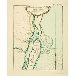
Plan du Port de St Augustin dans la Floride.
This chart shows a plan of the Port of St. Augustine in Florida.The only issue of this version of Bellin's map, slightly larger than the common version. Depths shown by s...
Date: Paris 1764
Selling price: ????
Please login to see price!
Sold
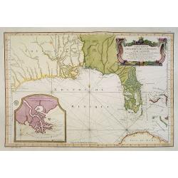
Carte Reduite Des Costes De La Louisiane Et De La Floride..
A well engraved and highly detailed chart of Florida, the Gulf Coast and the Mississippi Valley. This is one of the best examples of Florida as an Archipelago.The region ...
Date: Paris 1764
Selling price: ????
Please login to see price!
Sold in 2013

Carte des cinq Grands Lacs du Canada.
A good engraved map of the Great Lakes area, showing the imaginary islands of Philippeaux and Pontchartrain in Lake Superior. From l'Histoire générale des voyages .Bell...
Date: Paris, 1764
Selling price: ????
Please login to see price!
Sold in 2013

Plan De La Nouvelle-Orleans Sur les Manuscrits du Depot des Cartes De la Marine . . .
An important transitional and very detailed early map of New Orleans, copied after the original manuscript plan of the city drafted by Le Blond de la Tour in 1722. - the ...
Date: Paris, 1764
Selling price: ????
Please login to see price!
Sold in 2014

Carte Des Lacs Du Canada Pour sevir a l'Histoire Generale des Voyages.
Showing the all the Great Lakes in the traditional Bellin configuration. Jacques Nicolas Bellin (1703-1772) was one of the most important and proficient French cartograph...
Date: Paris, 1764
Selling price: ????
Please login to see price!
Sold in 2014

A New and Correct Chart of the Sea Coast of New England from Cape Codd to Casco Bay. . .
Two sheets, each 480 x 585 mm., not joined. This is one of the rarer of the large sea charts of New England to appear in Mount & Page's 'English Pilot Fourth Book'.Th...
Date: London, 1764
Selling price: ????
Please login to see price!
Sold in 2017
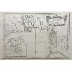
Carte Reduite des Costes de la Louisiane et de la Floride.
A very rare and large original engraved sea chart by Bellin from 1764. Details include Florida, the Gulf Coast and the Mississippi Valley. This is one of the best example...
Date: Paris, 1764
Selling price: ????
Please login to see price!
Sold in 2018
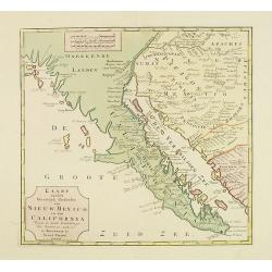
Kaart van het Westelyk Gedeelte van Nieuw Mexico en van California. . . MDCCLXV ..
A detailed map of the Baja California and Sonora, bounded on the north by the Colorado and Gila Rivers and approximately Mozatlan in the south, thus including parts of mo...
Date: Amsterdam, 1765
Selling price: ????
Please login to see price!
Sold in 2012
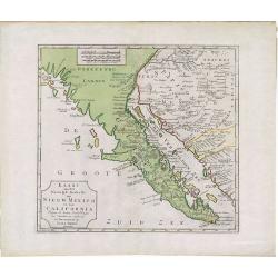
Kaart van het Westelyk gedeelte van Nieuw Mexico en van California
A detailed map of the Baja California and Sonora, bounded on the north by the Colorado and Gila Rivers and approximately Mozatlan in the south, thus including parts of mo...
Date: Amsterdam, 1765
Selling price: ????
Please login to see price!
Sold in 2014

A New & Accurate Map of North America, Including the British Acquisitions gain'd By the late War. 1763
Scarce map of the eastern part of North America from James Bay to the Gulf of Mexico in the year 1763. It shows boundaries, colonies, towns, cities, forts, and Indian tri...
Date: London, ca. 1765
Selling price: ????
Please login to see price!
Sold in 2016

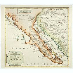
Kaart van het Westelyk Gedeelte van Nieuw Mexico en van California. . . MDCCLXV ..
A detailed map of the Baja California and Sonora, bounded on the north by the Colorado and Gila Rivers and approximately Mozatlan in the south, thus including parts of mo...
Date: Amsterdam, 1765
Selling price: ????
Please login to see price!
Sold in 2020
Kaart van het Westelyk Gedeelte van Nieuw Mexico en van California. . . MDCCLXV ..
A detailed map of the Baja California and Sonora, bounded on the north by the Colorado and Gila Rivers and approximately Mozatlan in the south, thus including parts of mo...
Date: Amsterdam, 1765
Selling price: ????
Please login to see price!
Sold in 2026

Grondvlakte van Nieuw Orleans de Hoofdstad van Louisiana. / De uitloop van de Rivier Missisippi./ De Oostelijke ingang van de Missisippi. . .
A sought-after, beautiful, decorative sheet that shows three maps arranged around a significant compass rose. This work represents Tirion's version of a first executed ma...
Date: Amsterdam, 1765
Selling price: ????
Please login to see price!
Sold in 2017

Carte Réduite de L'Ocean Septentrional compris entre l'Asie et l'Amerique.. (1766)
Large and detailed chart prepared by N.Bellin of east coast of Asia and western America, including Alaska, California, and Great Lakes region in the typical Bellin format...
Date: Paris 1766
Selling price: ????
Please login to see price!
Sold

Carte Réduite de L'Ocean Septentrional. . .
A first state, with no page number, price or Depot de la Marine stamp engraved anywhere. Large and detailed map prepared by Bellin of east coast of Asia and western Ameri...
Date: Paris 1766
Selling price: ????
Please login to see price!
Sold
![[North America].](/uploads/cache/39534-250x250.jpg)
[North America].
Two sheets (nos 1 & 3) of a larger 4 sheet wall map of North America, published by Postlethwayt, from his "Dictionary of Trade and Commerce".The work is bas...
Date: [London], ca. 1766
Selling price: ????
Please login to see price!
Sold in 2017

Carte Nouvelle d'Amerique..
Fine map of north and south America, engraved by J.E.T. Vallet and prepared by M.A.Moithey. In western part of North America a large "Mer de L' Quest" or Sea of...
Date: Paris 1767
Selling price: ????
Please login to see price!
Sold

A Plan of the City of Philadelphia, with the Country Adjacent.
Early small plan of Philadelphia, published in "The World displayed; or, a curious collection of voyages and travels...". Quite detailed with roads and houses...
Date: London, 1767
Selling price: ????
Please login to see price!
Sold in 2010

A Large Draught of New England New York and Long Island.
Two charts on one sheet showing the New England coast. The chart displayed here focuses on the New England coast from the Hudson River to the Penobscot River.Grierson pub...
Date: Dublin, 1767
Selling price: ????
Please login to see price!
Sold in 2017

North America.
A nice general map of North America, published in London during the latter half of the eighteenth century. It mentions many Native American Indian Tribes, shows 'New Albi...
Date: London, 1767
Selling price: ????
Please login to see price!
Sold in 2019

Grondvlakte van Nieuw Orleans, de Hoosdstad van Louisiana / De Uitloop van de Rivier Missisippi / De oostelyke Ingang van de Missisippi, met een Plan van het Fort, 't Welk het Kanaal Beheerscht
A sought-after, beautiful, decorative sheet that shows three maps arranged around a significant compass rose. This work represents Tirion's version of a map that was firs...
Date: Amsterdam, ca. 1769
Selling price: ????
Please login to see price!
Sold

Grondvlakte van Nieuw Orleans, de Hoosdstad van Louisiana / De Uitloop van de Rivier Missisippi / De oostelyke Ingang van de Missisippi, met een Plan van het Fort, 't Welk het Kanaal Beheerscht
A sought-after, beautiful, decorative sheet that shows three maps arranged around a large compass rose. This work represents Tirion's version of a first executed map by D...
Date: Amsterdam, ca. 1769
Selling price: ????
Please login to see price!
Sold in 2015

Nieuwe Kaart van Kanada, De Landen aan de Hudson's-Baay en de Noordwestelyke deelen van Noord-Amerika. . .
A decorative, interesting map of Canada and the Upper Midwest. It is centered on the Great Lakes and Hudson's Bay and was published by Issak Tirion. The map depicts the r...
Date: Amsterdam, 1769
Selling price: ????
Please login to see price!
Sold in 2022

Carte des Nouvelles découvertes. . .
This map is most notable for it's depiction of "Mer de L'Ouest" or "Sea of the West", a great sea, easily the size of the Mediterranean, to flow from ...
Date: Paris, 1770
Selling price: ????
Please login to see price!
Sold in 2022

America Septentrionalis, Concinnata juxta Observationes..
This exemplar represents Lotter?s version of Delisle?s foundation map of North America, published in 1700. The Great Lakes are actually based on the Coronelli model, whic...
Date: Augsburg, ca. 1770
Selling price: ????
Please login to see price!
Sold
America Septentrionalis, Concinnata juxta Observationes..
This exemplar represents Lotter's version of Delisle's foundation map of North America, published in 1700. The Great Lakes are actually based on the Coronelli model, whic...
Date: Augsburg, ca. 1770
Selling price: ????
Please login to see price!
Sold in 2011

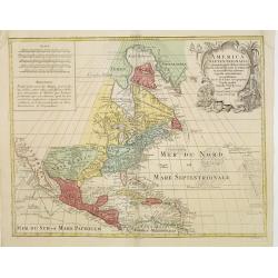
Amérique Septentrionale.
25Rigobert Bonne (1727-1795), French cartographer. His maps are found in a.o. Atlas Moderne (1762), Raynal's Histoire Philos. du Commerce des Indes (1774) and Atlas Encyc...
Date: Paris, c. 1770
Selling price: ????
Please login to see price!
Sold
![Untitled [Nordlicher Theil des Grossen Süd Meers].](/uploads/cache/23671-250x250.jpg)
Untitled [Nordlicher Theil des Grossen Süd Meers].
Uncommon map illustrating the Californian and some of the Mexican Pacific shores. With notations in German. In the upper central part some marks are visible due to cracks...
Date: Germany, 1750 - 1770
Selling price: ????
Please login to see price!
Sold
![Untitled [Nordlicher Theil des Grossen Süd Meers].](/uploads/cache/24713-250x250.jpg)
Untitled [Nordlicher Theil des Grossen Süd Meers].
Uncommon map illustrating the Californian and some of the Mexican Pacific shores. With notations in German. In the upper central part some marks are visible due to cracks...
Date: Germany, 1750 - 1770
Selling price: ????
Please login to see price!
Sold

N. America.
Uncommon map of North America, with unfinished coast north of California. Shows "Quivira" and "The supposed Str. of Annian". Locates Indian tribes.
Date: London, ca. 1770
Selling price: ????
Please login to see price!
Sold in 2014

North America Drawn & Engraved from the best Maps & Charts.
Important early hand-colored, copper engraved map of the British Colonies and the whole of North America, shortly after the conclusion of the French & Indian War and ...
Date: London, 1770
Selling price: ????
Please login to see price!
Sold in 2015

America Septentrionalis, Concinnata juxta Observationes..
This exemplar represents Lotter's version of Delisle's foundation map of North America, published in 1700. The Great Lakes are actually based on the Coronelli model, whic...
Date: Augsburg, ca. 1770
Selling price: ????
Please login to see price!
Sold in 2018

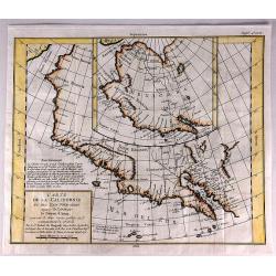
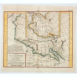
Carte de la Californie et des Pays Nord-Ouest..
From Diderot's Encyclopedia. The main map shows California and the north west coast as depicted in a four-sheet map of America, published by Claes Jansz Visscher in 1612:...
Date: Paris, 1770
Selling price: ????
Please login to see price!
Sold in 2020
![Vue de la Rue grande vers l'Eglise du Sud des Presbiteriennes a Boston. [Vue de Boston].](/uploads/cache/43546-250x250.jpg)
Vue de la Rue grande vers l'Eglise du Sud des Presbiteriennes a Boston. [Vue de Boston].
A "vue d'optique" or perspective view. These popular engravings were published in Europe during the last half of the 18th century. They were meant to be seen th...
Date: Augsburg, 1770
Selling price: ????
Please login to see price!
Sold in 2019

Partie de la carte du Captaine Cluny..
From Diderot's Encyclopaedia . Based on Captain Cluny's map of 1769 published in London in American Traveller .
Date: Paris 1771
Selling price: ????
Please login to see price!
Sold

Partie de la carte du Capitaine Cluny? publié en 1769.
A map of North America with a supposedly northwest passage.
Date: Paris, 1772
Selling price: ????
Please login to see price!
Sold

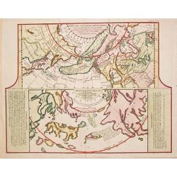
Carte Generale des Decouvertes de l' Amiral de Fonte representant la grande probabilite d'un Passage au Nord Ouest
The probably most extravagant of all the Northwest Passage maps after Thomas Jefferys, a passionate believer in the northern route to Asia and prepared this map to show t...
Date: Paris, 1772
Selling price: ????
Please login to see price!
Sold

Carte des parties nord est ouest de L'Amerique..
Map of North America, as well as Canada & Alaska. California & the Pacific Northwest coast to Alaska is still speculative, whereas the east coast is depicted from...
Date: Paris 1772
Selling price: ????
Please login to see price!
Sold
Carte des nouvelles découvertes/ Extrait d\'une Carte Japonoise de l\'Universe.
Gilles Robert de Vaugondy (!686-1766) and son Didier (1723-86), Paris geographers and publishers. Gilles succeedded Pierre Moulart Sanson in 1730. "Atlas Portatif&qu...
Date: Paris, 1772
Selling price: ????
Please login to see price!
Sold in 2017

Carte des parties nord et ouest de l' Amerique. . .
Map of North America, as well as Canada & Alaska. California & the Pacific Northwest coast to Alaska is still speculative, whereas the east coast is depicted from...
Date: Paris, 1772
Selling price: ????
Please login to see price!
Sold in 2014

Carte de la partie Septentrionale et Orientale .. (5 maps on one sheet)
Five maps on one sheet, showing California, Alaska and Siberia and Japan.Map I showing Alaska, California as a peninsular, eastern tip of Japan with a curious Islade Plat...
Date: Paris, 1772
Selling price: ????
Please login to see price!
Sold in 2023

Carte des parties Nord et Est de L'Asie...
Interesting map of the northern coastline of Russia, the eastern coast of Asia with Korea, Japan, and China, and a bit of the coast of America called Anian. With four sm...
Date: Paris, 1772
Selling price: ????
Please login to see price!
Sold in 2016
Carte de la Californie et des Pays Nord-Ouest Separes de l'Asie par le Detroit d'Aman.
An interesting study in the comparative cartography of the West Coast of North America in California. The work consists of extracts from two maps, both reportedly done b...
Date: Paris, 1772
Selling price: ????
Please login to see price!
Sold in 2017

Carte de la Californie Suivant.
A historically important depiction of the 5 most influential cartographic depictions of California, showing the evolution of how California was mapped between 1604 and 17...
Date: Paris, 1772
Selling price: ????
Please login to see price!
Sold in 2017
A Map of Part of West Florida from Pensacola to the Mouth of the Iberville River, with a view to shew the proper spot for a Settlement on the Mississipi.
Uncommon map of the Mississippi delta and coastal regions of Mississippi, Alabama and the panhandle of Florida., from the February 1772 edition of Gentleman's Magazine, w...
Date: London 1772
Selling price: ????
Please login to see price!
Sold in 2017

CARTE GENERALE DES DECOUVERTES de l'Amiral de Fonte, et autres navigateurs. . .
An extremely interesting map of the Northwest Coast, showing De L'Isle's conjectural northwest coast, based upon De Font and Russian Discoverers, including the Bay of the...
Date: Paris, 1772
Selling price: ????
Please login to see price!
Sold in 2019

CARTE GENERALE DES DECOUVERTES de l'Amiral de Fonte,representant la grande possibilite d'un PASSAGE AU NORD OUEST.
A fascinating map of the Northwestern part of America, illustrating the reports of De L'Isle of the Russian discoveries in the region prior to 1750, which he obtained dur...
Date: Paris, 1772
Selling price: ????
Please login to see price!
Sold in 2019

Carte des parties nord et ouest de L' Amerique. . .
An interesting map of North America, based upon an earlier map by Thomas Engel. His map of North America was issued in his 'Memoires Observations Geographique' in 1765, a...
Date: Paris, 1772
Selling price: ????
Please login to see price!
Sold in 2020
Carte de la Californie et des Pays Nord Ouest separes de L'Asie par le Detriot d'Anian. . .
Two map shown. The larger map prominently shows the Strait of Anian, Anian Regnum, Quivira Regnum, the Sierra Nevada, Nova Albion, Tontonteac Regnum, Tolm Regnum and a co...
Date: Paris, 1772
Selling price: ????
Please login to see price!
Sold in 2020

Carte generale des Decouvertes de L'Amiral de Fonte. . .
An interesting map of the northwest coast, showing de L'Isle's conjectural northwest coast, based upon that of de Font and Russian Discoverers, including the Bay of the W...
Date: Paris, 1772
Selling price: ????
Please login to see price!
Sold in 2020

General Map of the Discoveries of Admiral de Fonte representing the great probability of a Passage to the North West by Thomas Jefferys. . .
An attractive and interesting map issued in the supplement to Diderot's 'Encyclopedie' as part of the series of ten maps by de Vaugondy illustrating the then-current view...
Date: Paris, 1772
Selling price: ????
Please login to see price!
Sold in 2020

Carte du cours du Fleuve de St.Laurent..
Uncommon edition of this accurate map showing the lower St.Laurence. Second state.From Atlas Portatif pour servir a l'intelligence de l'Histoire Philosophique et Politiqu...
Date: Amsterdam 1773
Selling price: ????
Please login to see price!
Sold
