Browse Listings in America > North America

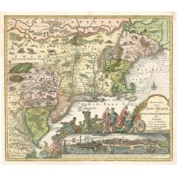
Belgii Pars Septentrionalis Communi Nomine vulgo Hollandia ... / Batavorum Coloniae Occidential Indiis Septentrionalis Americae implantate / India Orientalis Batavorum Commerciis, Potentia & Coloniis celeberrima. / Batavia / Niew Amsterdam.
Original old colored map of the Netherlands by JB Homann. Large inset maps of the Northeastern US from the Chesapeake to Massachusetts and Southeast Asia and additional v...
Date: Nuremberg, c.1750
Selling price: ????
Please login to see price!
Sold in 2011

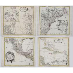
Accurata delineatio celeberrimae Regionis Ludovicianae ...
Includes the area from the Great Lakes to the Caribbean, and the basin of the river Mississippi in the centre of the map. Part of Louisiana in the top left inset. A very ...
Date: Augsburg, 1750
Selling price: ????
Please login to see price!
Sold in 2013

L\'AMERIQUE SEPTENTRIONALE Dressée sur les Relations les plus modernes des Voyageurs. . .
North America with inset of the Northwest including Nouvelle Albion, Strait of Anian, and other various fantastic possibilities of a Northwest Passage (Partie Nord-Ouest ...
Date: Paris, 1750
Selling price: ????
Please login to see price!
Sold in 2013

Salem - Eine stadt in Engelländischen America, in der Grafschafft Essex, ... Salem - Une ville de l'Amerique Angloise dans le Comte d'Essex. . .
A so-called optical print. A lively town-view and harbor scene of Salem, Massachusetts, with many people loading a vessel. Engraved by Balthazar Frederic Leizelt.This vie...
Date: Augsburg, 1750
Selling price: ????
Please login to see price!
Sold in 2015

Representation du feu terrible à nouvelle york.
So-called optical print of New York, showing several buildings along street engulfed in flames during fire on September 19, 1776, citizens being beaten by Redcoats, and l...
Date: Augsburg, c. 1750
Selling price: ????
Please login to see price!
Sold in 2013

Neu Yorck - Na Nouvelle York.
A so-called optical print engraved by B.F. Leizelt, with underneath captions in German and French. Below the image, Augsburg, "au Negoce commun de l'Academie Imperia...
Date: Augsburg, ca. 1750
Selling price: ????
Please login to see price!
Sold in 2013

Plan de la Ville de Boston et ses Environs.
One of the earliest obtainable town plans of Boston and Charlestown, with an extensive index of 16 specific sites at left, each located on the map. Shows Boston 13 years ...
Date: Paris, 1750
Selling price: ????
Please login to see price!
Sold in 2014

The Continent and Islands of America are divided and Possessed as follows. . .
A copper engraved map. Top half sheet of a 2-sheet map only. Printed in lower left corner is a key showing which regions and islands belong to the United States and Great...
Date: London, ca 1750
Selling price: ????
Please login to see price!
Sold in 2021

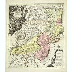
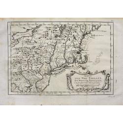
Pensylvania, Nova Jersey et Nova York..
One of the few maps to concentrate on this area and one of the most bizarre maps of North America ever published. The entire coastline is highly inaccurate; New Hampshire...
Date: Augsburg c.1751
Selling price: ????
Please login to see price!
Sold
Pensylvania, Nova Jersey et Nova York..
Pre-Revolutionary War era map based on Lewis Evans’ map of 1749 and one of the few maps to concentrate on this area and one of the most bizarre maps of North America ev...
Date: Augsburg, c.1751
Selling price: ????
Please login to see price!
Sold in 2011

Pensylvania, Nova Jersey et Nova York..
Pre-Revolutionary War era map based on Lewis Evans’ map of 1749 and one of the few maps to concentrate on this area and one of the most bizarre maps of North America ev...
Date: Augsburg, c.1751
Selling price: ????
Please login to see price!
Sold in 2019
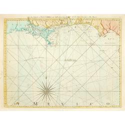
The Coast of West Florida and Louisiana..
Rare and important chart of Louisiana. Jeffery's was one of the most prolific and important English map publishers of the 18th century. His earliest known work was a plan...
Date: London 1752
Selling price: ????
Please login to see price!
Sold

Amerique Septentrionale par N. Sanson.
Small decorative map of the Americas with a very large CALIFORNIA AS AN ISLAND.
Date: Amsterdam 1752
Selling price: ????
Please login to see price!
Sold
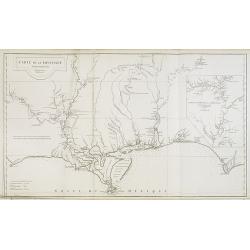
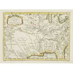
Carte de la Louisiane.
This map provides an accurate rendition of the lower Mississippi, the Arkansas, the Red, the Osage, and the lower Missouri rivers. Thomas Jefferson bought seven maps by A...
Date: Paris, 1752
Selling price: ????
Please login to see price!
Sold in 2009
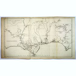
Carte de la Louisiane. . .
This map provides an accurate rendition of the lower Mississippi, the Arkansas, the Red, the Osage, and the lower Missouri rivers. Thomas Jefferson bought seven maps by A...
Date: Paris, 1752
Selling price: ????
Please login to see price!
Sold in 2016

Carte de la Louisiane.
This map provides an accurate rendition of the lower Mississippi, the Arkansas, the Red, the Osage, and the lower Missouri rivers. Thomas Jefferson bought seven maps by d...
Date: Paris, 1752
Selling price: ????
Please login to see price!
Sold in 2020

North America, Performed under the Patronage of Louis Duke of Orleans, First Prince of the Blood. By the Sieur d'Anville. . .
A lovely copper engraved map from 'The Universal Dictionary of Trade and Commerce (vols. 1 & 2)', by Malachy Postlethwayt / published by Paul Knapton, London, in 1755...
Date: London, 1752
Selling price: ????
Please login to see price!
Sold in 2020
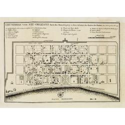
Grundriss von Neu-Orleans. . . N°18.
An important plan of New Orleans. In: Allgemeine Historie der Reisen zur Wasser und zu Lande: oder Sammlung aller Reisebeschreibungen.. in Englischen zusammen getragen, u...
Date: Leipzig, 1753
Selling price: ????
Please login to see price!
Sold in 2008

Karte von den Kpusten des Französischen Florida. . . N°3.
An important early city map of the South Carolina coast with Charlestown. In: Allgemeine Historie der Reisen zur Wasser und zu Lande: oder Sammlung aller Reisebeschreibun...
Date: Leipzig, 1753
Selling price: ????
Please login to see price!
Sold in 2008

Karte von der Bay Chesapeack und den benachbarten Landen. . .
Uncommon German text edition of Bellin's important and interesting map of the Chesapeake Bay, with excellent detail on New Jersey, Maryland, Virginia, and Pennsylvania. I...
Date: Leipzig, 1753
Selling price: ????
Please login to see price!
Sold
AMERICAE SEPTENTRIONALIS ad emendatiora Exemplaria adhuc edita jussu Aca. Reg. Scjent et. Pars I to IV.
Complete set of Euler's four-part map of North America, published in response to the maps of Mitchell and D'Anville. Part I covers the region from the Mississippi River ...
Date: Berlin, 1753
Selling price: ????
Please login to see price!
Sold in 2017

A Map of the British American Plantations extending from Boston in New England to Georgia. . .
A nice example of this early map of the British Colonies, issued just one year prior to the seminal map of John Mitchell. The map is based largely upon the work of D'Anvi...
Date: London, 1754
Selling price: ????
Please login to see price!
Sold in 2019

A MAP OF THE BRITISH AMERICAN PLANTATIONS, Extending From Boston.Including All The Back Settlements In The Respective Provinces, As Far As The Mississippi
Covers New York and areas of New England, Pennsylvania, Maryland, Virginia, North and South Carolina, Georgia and other states reaching to the Mississippi River. Iden...
Date: London, 1754
Selling price: ????
Please login to see price!
Sold in 2023

Carte de la Virginie et du Maryland..
A first state (of 5), with "Limites de Lord Fairfax".The late eighteenth century mapping of Virginia was dominated by Joshua Fry and Peter Jefferson's A Map of ...
Date: Paris 1755
Selling price: ????
Please login to see price!
Sold

Partie Occidentale de la Nouvelle France ou des Canada.
A fine large-scale map derived from Bellin's landmark map of the Great Lakes which first appeared in Charlevoix's Histoire in 1744. However, Homann's publication is more ...
Date: Nuremberg 1755
Selling price: ????
Please login to see price!
Sold

Partie de l\'Amerique septentrionale.. le cours de L\'Ohio..
From the Atlas Universel , a detailed map extending the length of the east coast from Penobscot Bay to Cape Fear and, in an inset, from Cape Fear to Fort St.Georges. This...
Date: Paris, 1755
Selling price: ????
Please login to see price!
Sold in 2008

Partie de l'Amerique Septent. .
A fine copy of this map of New Foundland, Nova Scotia and the course of the St.Lawrence to Lake Ontario. An inset shows Bellini's famous and important map of the Great La...
Date: Paris, 1755
Selling price: ????
Please login to see price!
Sold in 2014

Nieuwe kaart van de Grootbrittannische volkplantingen ..
A wonderful map of the situation in North America at the beginning of the French & Indian War. By the middle of the eighteenth century, the French, who claimed the en...
Date: Amsterdam 1755
Selling price: ????
Please login to see price!
Sold

Carte des possessions Angloises et Françoises du continent de l'Amerique Septentrionale. / Kaart van de Engelsche en Fransche bezittingen . . .
A great French and Indian War map, with the states of Florida, Georgia, North and South Carolina, Virginia, Pennsylvania, Maryland, Jersey, New York, Connecticut, Massach...
Date: Amsterdam, 1755
Selling price: ????
Please login to see price!
Sold in 2019

Canada Louisiane et Terres Angloises.
The northwest sheet of a four-sheet map featuring the Great Lakes and upper Mississippi River. Large, decorative cartouche designed by Gravelot. The map was based in part...
Date: Paris, 1755
Selling price: ????
Please login to see price!
Sold in 2012

Partie de l\'Amerique septent? Qui comprend la nouvelle France. . .
A fine copy of this map of New Foundland, Nova Scotia and the course of the St. Lawrence to Lake Ontario in a fourth state.An inset shows Bellini's famous and important m...
Date: Paris, 1755
Selling price: ????
Please login to see price!
Sold in 2013

Partie Occidentale de la Nouvelle France ou des Canada.
A fine large-scale map derived from Bellin's landmark map of the Great Lakes which first appeared in Charlevoix's Histoire in 1744. The chart incorporates the work of Sie...
Date: Nuremberg, 1755
Selling price: ????
Please login to see price!
Sold in 2015

Partie Occidentale de la Nouvelle France ou de Canada.
An important and influential map of the Great Lakes region during the time of French colonial occupation. This map was originally engraved by Jacques Bellin in 1745, howe...
Date: Nuremberg, 1755
Selling price: ????
Please login to see price!
Sold in 2017

A Map of the British and French Settlements in North America.
An interesting and informative map highlighting (in green) the areas of dispute between England and France and the beginning of the French & Indian War. Explanatory n...
Date: London, 1755
Selling price: ????
Please login to see price!
Sold in 2016

A Map of the British and French Settlements in North America.
This is the first map illustrating the French - British conflict in North America. It was issued just before the French and Indian War was officially. It illustrates by h...
Date: London, 1755
Selling price: ????
Please login to see price!
Sold in 2017

Carte De La Virginie Et Du Maryland Dressee sur la grande carte Angloise de Mrs. Josue Fry et Pierre Jefferson (First State, with Lord Fairfax Line Shown), 1755
A copperplate border-colored map of Virginia and Maryland. A striking example of the single sheet version of the seminal Fry-Jefferson map, engraved by Elisabeth Haussard...
Date: Paris, 1755
Selling price: ????
Please login to see price!
Sold in 2017

Karte von den Kusten des Franzosischen Florida.
A nice, uncommon map of French Florida, covering South Carolina, Georgia and Florida, from the German edition of Charlevoix's History of New France.The map extent is fro...
Date: Paris, 1744-1755
Selling price: ????
Please login to see price!
Sold in 2019
![Carolinae[,] Floridae nec non Insularum Bahamensium cum partibus adjacendibus delineatio ad Exemplar Londinense in lucem edita a Ioh. Michael Seligmann[,] Norimbergae Ao. 1755](/uploads/cache/82109-250x250.jpg)
Carolinae[,] Floridae nec non Insularum Bahamensium cum partibus adjacendibus delineatio ad Exemplar Londinense in lucem edita a Ioh. Michael Seligmann[,] Norimbergae Ao. 1755
The first and only continental edition of one of the finest and most important maps of southeastern North America – Catesby's Map of Carolina, Florida, and the Bahama I...
Date: Nuremberg, 1755
Selling price: ????
Please login to see price!
Sold in 2020

A Map of the British and French Settlements in North America.
An interesting and informative map highlighting the dispute (the shaded areas) between England and France at the beginning of the French & Indian War. Explanatory not...
Date: London, 1755
Selling price: ????
Please login to see price!
Sold in 2019

Carte D'Une Partie de L' AMERIQUE SEPTENTRIONALE.
A fine example of this highly detailed set of maps illustrating the British Colonies in North America at the conclusion of the American Revolution, published by Soules in...
Date: Paris, ca 1755
Selling price: ????
Please login to see price!
Sold in 2019

Canada Louisiane et Terres Angloises.
The two northern sheets of a four-sheet map featuring the Great Lakes, the upper Mississippi River and the Atlantic coast region. Large, decorative cartouche designed by ...
Date: Paris, 1755
Selling price: ????
Please login to see price!
Sold in 2020

Partie Occidentale de la NOUVELLE FRANCE ou du CANADA.
A fine large-scale map derived from Bellin's landmark map of the Great Lakes which first appeared in Charlevoix's Histoire in 1744. However, Homann's publication is more ...
Date: Nuremberg, 1755
Selling price: ????
Please login to see price!
Sold in 2020
![CARTE DE L'AMERIQUE SEPTENTRIONALE, Depuis le 28 Degre...[Sea of the West]](/uploads/cache/85714-250x250.jpg)
CARTE DE L'AMERIQUE SEPTENTRIONALE, Depuis le 28 Degre...[Sea of the West]
A large and rare map that covers nearly all of North America, especially the USA. An important map of North America, with interesting geographical features: * Incorperati...
Date: Paris, 1755
Selling price: ????
Please login to see price!
Sold in 2021

Karte von den Küsten des Französischen Florida..
An attractive map of the coast from Cape Fear, North Carolina, to St. Augustine, Florida. This is a German adaptation of a Bellin map, identifying rivers and major towns....
Date: Leipzig 1756
Selling price: ????
Please login to see price!
Sold

Amerique Septentrionale avec les Routes, Distances en miles, Limites et Etablissements François et Anglois Par le Docteur Mitchel Traduit de 'Anglois..
First French edition of the famous John Mitchell map of the British and French Dominions in North America. Includes the word Limites in the title rather than Villages whi...
Date: Paris 1756
Selling price: ????
Please login to see price!
Sold
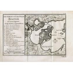
Grundriss von der Stadt Boston und ihren Gegenden
Rare German edition of this detailed plan of the city of Boston with its harbour and surrounding area. Indicates principal buildings such as the various forts and their a...
Date: Paris, c1756
Selling price: ????
Please login to see price!
Sold in 2008

Baye et Port de Boston. Tire des Manuscrits de M. le Chevalier de la Rigaudiere Lieutenant de Vaissau du Roy . A Paris par le Rouge. Rue des Augustins
Unrecorded and exceptional rare chart of the Bay around Boston during the French & Indian WarAn unrecorded sea chart of Boston by G. L. le Rouge during the French &am...
Date: Paris, 1756
Selling price: ????
Please login to see price!
Sold in 2010

Carte des Possessions Françoises et Angloises dans le Canada et partie de la Lousiane. . .
First state, separately published. This map was published in 1756 to provide information on the French-Indian wars.
Date: Paris, 1756
Selling price: ????
Please login to see price!
Sold in 2013

Carte des Possessions Françoises et Angloises dans le Canada et Partie de la Louisiana. . .
First state of this separately published map of the European Colonies in the New World east of the Mississippi River. This map was published in 1756 to provide informatio...
Date: Paris, 1756
Selling price: ????
Please login to see price!
Sold in 2021

Carte de la Caroline et Georgie..
Jaques Nicolaas Bellin (1703-1772) was one of the most important and proficient French cartographers of the mid-eighteenth century. He was appointed the first Ingenieur H...
Date: Paris 1757
Selling price: ????
Please login to see price!
Sold

Carte de la Californie, Levée par la Société des Jesuites..
Uncommon updated version of Father Kino's epoch-making map of 1705 which was finally to decide De L'Isle as to California being a peninsula and, through him, to influence...
Date: Paris, after 1757
Selling price: ????
Please login to see price!
Sold
Carte de la Louisiane et pays Voisins.
Accurate map showing the lower Mississippi River and surrounding areas, the ranges and villages of numerous Indian tribes are shown.Jacques Nicolas Bellin (1703-1772) was...
Date: Paris, 1757
Selling price: ????
Please login to see price!
Sold in 2011

Carte de la Louisiane et pays Voisins.
Accurate map showing the lower Mississippi River and surrounding areas, the ranges and villages of numerous Indian tribes are shown.Jacques Nicolaas Bellin (1703-1772) wa...
Date: Paris 1757
Selling price: ????
Please login to see price!
Sold

Carte de la Caroline et Georgie..
Accurate map depicting the eastern coast of the United States from Savannah to Edenton as well as the inland corresponding to today Carolinas. Includes part of Georgia.Ja...
Date: Paris 1757
Selling price: ????
Please login to see price!
Sold

Carte de la Nouvelle Angleterre, Nouvelle Yorck et Pensilvanie..
Lovely map of the northeast, fully engraved with mountains. The colonies are shown confined east of the Appalachian Mountains, with the "Nations Iroquoises" wes...
Date: Paris 1757
Selling price: ????
Please login to see price!
Sold

Carte Des Lacs Du Canada Pour sevir a l'Histoire Generale des Voyages.
Showing the all the Great Lakes in the traditional Bellin configuration. Jacques Nicolas Bellin (1703-1772) was one of the most important and proficient French cartograph...
Date: Paris, 1757
Selling price: ????
Please login to see price!
Sold in 2011

Carte de la Baye de Chesapeack et Pays Voisins. . .
Very attractive map showing both Chesapeake and Delaware Bays and the coast of New Jersey, Maryland and Virginia down to Cape Charles and Cape Henry. Including Philadelph...
Date: Paris, 1757
Selling price: ????
Please login to see price!
Sold

Plan de la Nouvelle Orleans. . .
An important transitional and very detailed early map of New Orleans, copied after the original manuscript town-plan of the city drafted by Le Blond de la Tour in 1722. I...
Date: Paris, 1757
Selling price: ????
Please login to see price!
Sold in 2009

Carta de la Mar del Sur, ò Mar pacifico, entre el Equador, y 39½ de latitud Septentrional hallada por el Almirante Jorge Anson en el Galion de Philipinas, que apresò.
Scarce map of the west coast of America, covering part of Mexico and California, copied from Anson's chart of 1748. Reaches as far north as Punta de los Reyes and Los Far...
Date: Madrid, 1757
Selling price: ????
Please login to see price!
Sold in 2013

Carte de la Baye de Chesapeack et Pays Voisins. . .
Very attractive map showing both Chesapeake and Delaware Bays and the coast of New Jersey, Maryland and Virginia down to Cape Charles and Cape Henry. Including Philadelph...
Date: Paris, 1757
Selling price: ????
Please login to see price!
Sold in 2018

Carte de la Caroline et Georgie..
Common map depicting the eastern coast of the United States from Savannah to Edenton as well as the inland corresponding to today Carolinas. Includes part of Georgia.Jacq...
Date: Paris, 1757
Selling price: ????
Please login to see price!
Sold in 2017

Carte de la Caroline et Georgie.
A pleasant map depicting the eastern coast of the United States from Savannah (GA) to Edenton (NC) as well as the inland corresponding to today Carolinas. Includes part o...
Date: Paris, 1757
Selling price: ????
Please login to see price!
Sold in 2019

Carte de la Virginie, de la Baye Chesapeack, et Pays Voisins.
An attractive and detailed map of the Chesapeake, Virginia, Maryland, Delaware, just before the settlement between Penn and Lord Baltimore, with Delaware properly shown a...
Date: Paris, 1757
Selling price: ????
Please login to see price!
Sold in 2020
Recens Edita totius Belgii, in America
Arguably one of the most recognizable maps of the Northeastern American colonies this fifth state example of Novi Belgii by Tobias Conrad Lotter series does not disappoin...
Date: Augsburg, Germany 1757
Selling price: ????
Please login to see price!
Sold in 2023

Karte von Luisiana, dem Laufe des Mississipi und den benachbarten Laendern. . .
A scarce German text edition of de l'Isles map, covering all the known United States, from the Rio del Norte (extending north almost to the Missouri headwaters) to the Gr...
Date: Leipzig, 1744 - 1758
Selling price: ????
Please login to see price!
Sold in 2011

Karte von der Bay Chesapeack und den benachbarten Landen
Bellin\'s important and interesting map of the Chesapeake Bay, with excellent detail on New Jersey, Maryland, Virginia, and Pennsylvania. Indicating many cities and vill...
Date: Paris, c.1758
Selling price: ????
Please login to see price!
Sold in 2008
Karte von Neu England Neu Yorck und Pensilvanien.
Bellin's important and interesting map of the North-East U.S. German Edition published in "Historie der Reisen." Very detailed, showing many cities and villages...
Date: Paris, c1758
Selling price: ????
Please login to see price!
Sold in 2008

A DRAUGHT OF VIRGINA from the Capes to York in York River and to Kuiquotan or Hamton in James River.
A large fragment of this significant chart. Shows the cities of Norfolk and Hamton, many bays, islands, and depth soundings.Includes the large title cartouche, a compass ...
Date: London,Mount & Page, c1758
Selling price: ????
Please login to see price!
Sold in 2010

Pensylvania, Nova Jersey et Nova York..
One of the few maps to concentrate on this area and one of the most bizarre maps of North America ever published. It was based on a very rare map by Lewis Evans published...
Date: Augsburg c.1760
Selling price: ????
Please login to see price!
Sold

Amérique Septentrionale divisée en ses principales..
A finely engraved map of North America, prepared by J.B.Nolin. The map is most notable for it's depiction of Mer de L'Quest or Sea of the West, a great sea, easily the si...
Date: Paris c.1760
Selling price: ????
Please login to see price!
Sold

NEW YORK AND PENSILVANIA
Charming little map of the Great Lakes, showing also Maryland, New York, and Pennsylvania. From the Atlas Minimus Illustratus. Includes Philadelphia, Ft. du Quesne, Kuski...
Date: London, c.1760
Selling price: ????
Please login to see price!
Sold in 2009

America Septentrionalis concinnata . . .
After the foundation map by de L'Isle published in 1700: which was the first map to reconnect California to the mainland and shows good detail for the Great Lakes and Hud...
Date: Augsburg, 1760
Selling price: ????
Please login to see price!
Sold

Carolina By H. Moll, Geographer.
A detailed map that includes the Limit of King Charles ye II Granted to ye Present Proprietors of Carolina in 1663, the south bounds of Carolina (well into Florida), note...
Date: London, c 1760
Selling price: ????
Please login to see price!
Sold in 2013

Mappa Geographica Americae Septentrionalis ad Emendatiora Exemplaria adhuc Edita . . .
Printed from 4 plates and showing the northern half continent with the Caribbean. Copper engraved map with original outline color, printed from 4 plates, after Leonhard E...
Date: Berlin c. 1760
Selling price: ????
Please login to see price!
Sold in 2014

America Septentrionalis concinnata...
A copperplate colored map of the north east America, that shows California as an island, after the foundation map by de L'Isle published in 1700, which was the first map ...
Date: Augsburg, 1760
Selling price: ????
Please login to see price!
Sold in 2017

America septentrionalis oder Mitternachtiger theil von America bestehend in Neu Brittania, Canada, Neu Engeland, Neu Schotland, Neu Jorck, Pensylvania, Carolina, Florida, Georgien. . .
A rare German map of the East Coast of North America. Shows the British Colonies at the end of the Franco-Indian War, and extends from Newfoundland until Florida, and wes...
Date: Augsburg, ca 1760
Selling price: ????
Please login to see price!
Sold in 2018

Theatrum belli in America Septentrionali. II. foliis comprehensum jussu Acad. Reg. Scient. et Eleg. Litt. exhibet I. C. Rhode Ac: Geogr.
1761 RHODE, I.C. - Rare, separately issued map of the United States and Eastern Canada, Theater of the French and Indian War
Date: Berlin, 1761
Selling price: ????
Please login to see price!
Sold in 2018
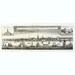
The East Prospect of the City of Philadelphia, in the Province of Pennsylvania.
This copper engraving view is based on the famous George Heap view, first published in c.1756. The print shows the city as a bustling river port of some importance and so...
Date: London, 1761
Selling price: ????
Please login to see price!
Sold in 2019

L'Amerique Septentrionale divisé en fes principaux.
A finely engraved map of North America, prepared by Janvier. The map is most notable for it's depiction of Mer de L'Quest or Sea of the West, a great sea, easily the size...
Date: Paris 1762
Selling price: ????
Please login to see price!
Sold
