Theatrum orbis terrarum - including the 'Parergon' and 'Nomenclator
The publication of the Theatrum Orbis Terrarum in 1570 marked an epoch in the history of cartography. ”It was the first uniformly sized, systematic collection of maps of the countries of the world based only on contemporary knowledge since the days of Ptolemy, and in that sense may be called the first modern atlas.” – R.V. Tooley.
”It's great commercial success enabled it to make a great contribution to geographical culture throughout Europe at the end of the sixteenth century”- Skelton.
Shape and contents set the standard for later atlases when the center of the map trade moved from Antwerp to Amsterdam.
 The Theatrum consists of two elements: text and maps. Ortelius reduced the best available maps to a uniform format. Further, the Theatrum was the first major printed work of any kind to include scholarly citations of authorities (i.e. the original mapmakers), thus introducing for the first time the concept of footnoting to Western scholarship. Additionally, he included the names of many other cartographers and geographers on his list. This "Catalogus auctorum tabularum geographicarum", is one of the major peculiarities of the atlas.
Ortelius and his successors kept his list of map authors up-to-date. In the first edition of 1570 the list included 87 names. In this posthumous edition of 1603, it contained 183 names.
Nomenclator Ptolemaicus.
Ortelius interest in history is seen in the addition of the
Nomenclator Ptolemaicus, with its own title page,
this was a list of place names, areas, islands, etc., taken from Ptolemy's Geographia, and their modern equivalents.
The atlas also contains De Mona Druidum Insula...Epistola, a six-folio-page letter by the British geographer
Humphrey Llwyd with a description of the islands of Anglesey and Man.
All Latin editions contained these scientific appendices, which Ortelius apparently regarded as unnecessary in most other editions.
The first edition includes his bibliography.
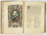
Abraham Ortelius was one of the most prominent citizens of Antwerp at a time when this city was a major European and, by extension, global trading center. His first biography was written shortly after his death in the form of a book of mourning, entitled Insignium huius aevi poetarum lacrymae, in obytum Cl.V. Abrahami Ortelii, Antverpiani. Its author was his good friend Francis Sweertius, and it appeared in 1601. This Latin edition of 1603 was the first edition to include a summarised version of this bibliography of Ortelius and the section is followed by an engraved full-page memorial to Ortelius, incorporating a miniature circular portrait of him.
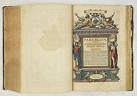 Parergon.
Ortelius further included a massive appendix (the Parergon), consisting of a detailed classical atlas, to appeal to Renaissance Europe's fascination with the ancient world.
In fact, this collection of maps of the ancient world was so significant that it became the model for all historical atlases published throughout the seventeenth century. ”The maps and plates in the Parergon have to be evaluated as
the most outstanding engravings depicting the widespread interest in classical geography in the 16th century” - Koeman.
Unlike the Theatrum, which consisted of existing maps reduced by Ortelius, the maps in the Parergon were drawn
by Ortelius himself. As a scholar of antiquity, a dealer in antiques, and a visitor to ancient sites, he was well prepared to execute the maps and all the maps from the Parergon reflect his passion for the ancient world.
Ortelius’s Parergon began as a companion to his Theatrum but eventually, it became an independent work.
Abraham Ortelius himself drew all his maps in manuscript before passing them to the engravers Frans Hogenberg, Ambrosius and Ferdinand Arsenius.
The Theatrum was printed at Ortelius's expense. The heirs of Ortelius sold the copperplates and the publication rights in 1601 to Jan Baptist Vrients, who added some new maps. After 1612, the year of Vrient's death, the copperplates passed to the Moretus brothers, the successors of Christoffel Plantin.
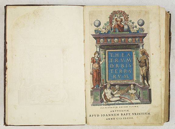
Theatrum orbis terrarum, Antwerp: Jan Baptist Vrients, 1603.
3 parts in one volume (including the 'Parergon' and 'Nomenclator'), folio (45 x 31cm). Mounted on guards throughout.
With full period hand-colouring throughout. Hand-coloured engraved allegorical general title, with full-page engraving of the arms of Philip II of Spain on the verso, engraved full-page memorial to Ortelius incorporating a small circular portrait of him, full-page engraved portrait of Ortelius by Phillip Galle, hand-colored engraved section-title to the Parergon
with architectural surround, uncoloured engraved vignette on letterpress section title to the Nomenclator.
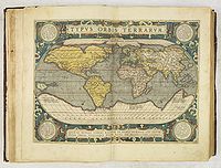
156 double-page hand-coloured engravings on 151 mapsheets (including 38 in the Parergon, 2 costume plates, 3 views), numerous woodcut initials.
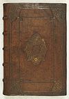
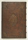 Contemporary brown calf, covers bordered and panelled in gilt and blind, covers with a large central design in gilt,
spine in seven compartments with raised bands, blind ruled in gilt on either side of each band, compartments
with date "1603" and title "ORTELLI THEATRVM ORBIS". The front and back covers are richly tooled
with a center piece. Front cover has "THEA / TRUM OR / BIS TER / RARUM". Verso a center piece with Goddess
of justice surrounded by a motto "QUOD TIBI FIERI NON VIS ALTERI NE FECERIS" (Do unto others as you would have done unto you.)
Contemporary brown calf, covers bordered and panelled in gilt and blind, covers with a large central design in gilt,
spine in seven compartments with raised bands, blind ruled in gilt on either side of each band, compartments
with date "1603" and title "ORTELLI THEATRVM ORBIS". The front and back covers are richly tooled
with a center piece. Front cover has "THEA / TRUM OR / BIS TER / RARUM". Verso a center piece with Goddess
of justice surrounded by a motto "QUOD TIBI FIERI NON VIS ALTERI NE FECERIS" (Do unto others as you would have done unto you.)
Examples in bright original coloring and still in a fine contemporary, and richly tooled binding are rare nowadays.
This is a very fine example of Ortelius's Renaissance masterwork: the first true atlas, here with bright and full contemporary hand coloring. This Latin edition published by Jan Baptist Vrients is one of the most complete issues of the 'Theatrum Orbis' and includes both the 'Parergon' and 'Nomenclator.
Marcel v.d.Broecke estimates that 300 copies of this edition are printed.
This item has been sold.
The Theatrum... of Abraham Ortelius was one of the most brilliant and innovative of all Renaissance books. It was the first true atlas in the modern sense of the word, and as such, it introduced an entirely new and standardized method for studying geography. For the first time in one volume, all parts of the globe were treated comprehensively and uniformly, and thus it presented as complete a picture as was then possible of the whole world.
Ortelius published editions of his atlas not only in Latin, the traditional language of the scholarly elite, but in the six major European vernaculars: German, Dutch, French, Italian, English and Spanish. The Theatrum was therefore equally at home in the library of a scholar in Paris, a country gentleman in Kent, or a merchant in Grenada.
This widespread dissemination had profound results in an age when geographical knowledge was in a rudimentary state:
The information laid out in the Theatrum became the universally accepted vision of the world.
Another strategy used to make the atlas more accessible to the public was the inclusion of beautiful embellishments in the popular mannerist style, thus appealing to contemporary aesthetic tastes, and aligning the Theatrum with the other outstanding artistic accomplishments of the age. In speaking of the maps in the Theatrum, the noted art historian, James A. Welu, comments on ”their richness of ornamentation, [they are] a combination of science and art that has rarely been surpassed in the history of mapmaking ... Ortelius's Theatrum is known for its numerous
decorative cartouches, which undoubtedly added to the atlas's long popularity” - Art and Cartography, pp. 145-146.
Ortelius played a pivotal role in disseminating the revelations of the important explorations and cartographical works of his time. The enthusiasm he and his colleagues felt for their task is suggested in the quote from Cicero at the bottom of the world map, which may be loosely translated: ”How can human affairs be taken seriously by one who contemplates the great world and all eternity? ”
In its comprehensive coverage of the world, the uniform excellence of its maps, the standardized style and format, the extensive use of the vernacular for marketing, its scholarly citations, and massive classical appendix - the
Theatrum Orbis Terrarum of Abraham Ortelius had no precedent.
 ORTELIUS, Abraham (1527-1598)
Abraham Ortel, better known as Ortelius, was born in Antwerp, and after studying Greek, Latin, and mathematics, started his career as a cartographer. Later, together with his sister, he became a seller of books, prints and maps. Traveling widely, especially to the great book fairs, his business prospered and he established contacts with the literati in many lands. On one such visit to England, possibly seeking temporary refuge from religious persecution,
He met William Camden, whom he is said to have encouraged in the production of the Britannia.
A turning point in his career was reached in 1564 with the publication of a World Map in eight sheets of which only one copy is known: other individual maps followed, and then - at the suggestion of a friend - he gathered together a
collection of maps from contacts among European cartographers and had them engraved in uniform size and issued in 1570 as the Theatrum Orbis Terrarum (Atlas of the Whole World).
Abraham Ortelius became the Royal Cartographer to Philip II, King of Spain. Philip sent him a gold necklace worth one thousand ducats.
He died on the 28th of June 1598 at the age of 71.
Although Lafreri and others in Italy had published collections of 'modern' maps in book form in earlier years, the Theatrum was the first uniformly sized, systematic collection of maps. It can hence be called the first atlas, although that term itself was not used until twenty years later by Mercator.
At the age of 19, Abraham Ortels' name was found in the register of the guild of St. Luke as "afsetter" or colorist of maps and prints. He appears to have reached a very advanced level of skill in this craft, as some customers continued to insist on buying atlases colored by him personally, at a time when he had already developed into a publisher, cartographer/merchant.
Ortelius was never married and lived with his sister Anna, a situation that would not change throughout his life.
Real prosperity arrived with the publication in 1570 of his atlas, and it was his sister Anne who took over the task
of coloring and remained a competent colorist for the rest of her life. Incidentally, most map coloring at this
time was done by children.
Useful reading :
Marcel van den Broecke - Ortelius Atlas Maps.
