Wish List
![Lutece conquise par les François sur les Romains ou second plan de la ville de Paris [...] par M.L.C.D.L.M.](/uploads/cache/42141-250x250.jpg)
Lutece conquise par les François sur les Romains ou second plan de la ville de Paris [...] par M.L.C.D.L.M.
Engraved plan of Paris, published in "Traité de la police de Nicolas de Lamare". Oriented to the North with a compass rose and equipped with a double scale (40...
Place & Date: Paris, 1729
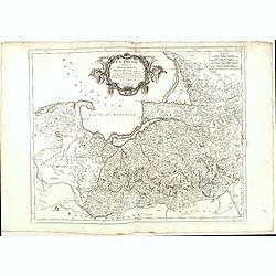
La Prusse divisée en Prusse Royale et Prusse Ducale.
The map extends from Memem, Danzig and Rosienne in the North to Novigrod in the southeast and Thorn on the Wessel in the southwest. Shows the Gulf of Danzig and part of P...
- $200 / ≈ €187
Place & Date: Venice, 1776 - 1784
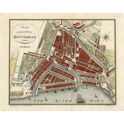
Plan of the city of Rotterdam
Charming bird's-eye plan of the city of Rotterdam shows farms on the outskirts and ships in the River Maas. Compass rose in the corner.
Place & Date: London, 1792
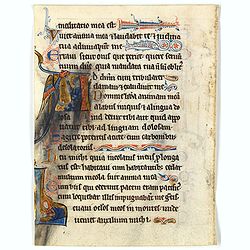
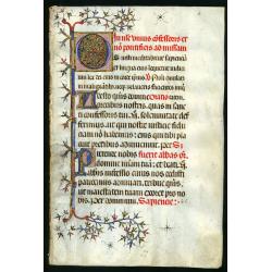
Illuminated leaf from a liturgical Psalter.
Very fine illuminated leaf from a liturgical Psalter in Latin. Lines in a slightly irregular gothic hand, black ink, plummet ruling. Very fine initial extended in the mar...
Place & Date: England, c. 1280
Selling price: $1000
Sold in 2022
![Le Royaume de Siam avec Les Royaumes Qui Luy sont Tributaries & c. / La Royaume de Siam avec les royaumes qui luy sont Tributaires, et les Isles de Sumatra, Andemaon, etc. . . [two sheet map]](/uploads/cache/40698-250x250.jpg)
Le Royaume de Siam avec Les Royaumes Qui Luy sont Tributaries & c. / La Royaume de Siam avec les royaumes qui luy sont Tributaires, et les Isles de Sumatra, Andemaon, etc. . . [two sheet map]
Influential map of Southeast Asia and the East Indies including modern day Thailand, southern Vietnam, Cambodia, Malaysia, Singapore, Borneo, Sumatra and Java. Ottens inc...
Place & Date: Amsterdam, 1710
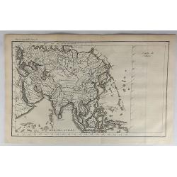
Carte de l'Asie.
A striking map of Asia. It is from “METHODE POUR ETUDIER L’HISTOIRE” by L’Abbe Lenglet du Fresnoy, published in Paris in 1729. The map is quite rare, and is not n...
Place & Date: Paris, 1729
Selling price: $11
Sold in 2021

PARADIS LATIN - Number One.
Poster for the Nuit de Paradis review, by Jean-Marie Rivière, the first Paradis Latin review in 1979.Read more about Poster History [+]
- $180 / ≈ €168
Place & Date: Paris, 1978

L'Heoro-taire brun. Pl.65.
A very rare print of a humming bird from Histoire naturelle et générale des colibris, oiseaux-mouches, jacamars et promerops, by Jean Baptiste Audebert. Before his deat...
- $230 / ≈ €215
Place & Date: Paris, 1800-1802
Leaf on vellum from a Missal.
A very fine Missal leaf, written in Latin. RECTO: A wonderful initial O decorated with pen work in red, purple and blue. The initial is 6x6cm. VERSO: one initial "I&...
Place & Date: France, c. 1410
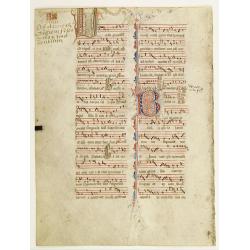
Leaf on vellum from an antiphonary.
A more than 600 years old antiphonary leaf, written in Besançon, in 1370. Musical notation on 4 bars, the staves are in red and the notes in black: numerous pen-flourish...
Place & Date: Besançon, 1370
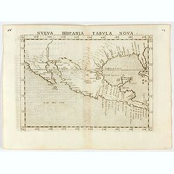
Nueva Hispania tabula nova.
Uncommon first edition of this early map of New Spain, Florida and Gulf of Mexico. The map is an enlarged version of Giacomo Gastaldi's map published in 1548. Nomenclatur...
Place & Date: Venice, 1561
Selling price: $1000
Sold in 2024
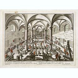
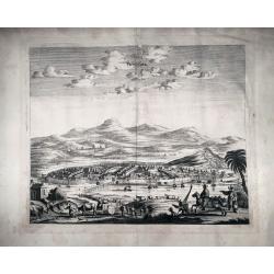
Per telecopium exhibitio partis inferioris armamentarii. / Representation en perspective de la partie inferieure d'un arsenal. . .
RARE. Engraved optical print by Georg Balthasar Probst of a arsenal.
Place & Date: Augsburg, 1750
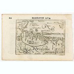
Iava Maior.
Very fine miniature map of Java, engraved by Benjamin Wright (1575-1613). This early map contains detailed geography and nomenclature around the northern coastline of the...
Place & Date: Amsterdam, Cornelis Claes, 1606
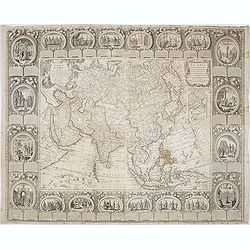
Le Nouveau et Curieux Atlas Geographique et historique, ou Le Divertissement des Empereurs, Roys, et Princes. Tant dans la Guerre que dans la Paix. Dédié A Son A.R. Monseigneur le Duc d'Orléans Regent du Roîaume de France.
Charming world atlas with double hemisphere world and the North American map feature the Island of California. In Asia and the Pacific, Australia is incompletely mapped a...
Place & Date: Paris, 1719

Sabena (USA - NYC).
Sabena Belgian World Airlines poster showing the skyline of New York in abstract style. Published by Rali Brisart in Belgium.La Sabena, acronym for Societé Anonyme Belg...
Place & Date: Brussels, ca. 1970
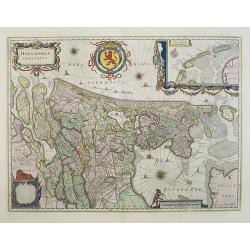
Hollandia Comitatus.
Orientated west to the top of the sheet, this presents the County of Holland in the classical orientation for seventeenth-century maps, with Amsterdam at the center. The ...
Place & Date: Amsterdam, 1660
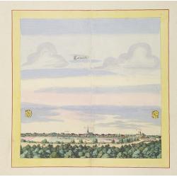
Calvorde.
Very decorative and rare panoramic of Calvörde, Bez. Magdeburg.The engraver and publisher of prints, Mrs. Anna Beek of the Hague, enlarged the print and mounted it on l...
Place & Date: The Hague, ca. 1700
CARTE DE L'ARCHIPEL AU NORD DE L'ISLE DE FRANCE. . . - REUNION,MAURITIUS,SEYCHELLES,DIEGO GARCIA.
A rare, large, and fine antique naval chart, depicting the Indian Ocean from as low as Mauritius to the southernmost Maldives islands, with an inset map of the Seychelles...
Place & Date: Paris, 1776
Selling price: $300
Sold in 2021
Carte d'Asie divisée en ses principaux Etats.
Uncommon and decorative "carte à figures" wall map, prepared by Clouet, with superb decoration including a wonderful rococo border with vignettes describing hi...
Place & Date: Paris, Mondhare, 1787
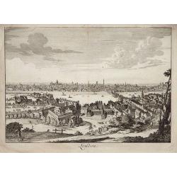
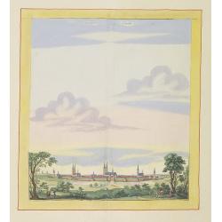
Paris, Lutetia, Parisii, Ville Capitale du Royaume de France.
View of Paris seen from the hill "Belleville based on that of Merian (1616) but updated with the new gates Saint-Denis and Saint-Martin. With a key 1-78 and A-Z. Sur...
Place & Date: Paris, after 1676
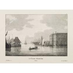
Le Chantier d'Amsterdam.
Decorative lithography representing the head quarters of the V.O.C. and shipyard in Amsterdam. The building serves nowadays as the Maritime Museum. After a painting by A....
Place & Date: Brussels, J. B. A. Jobard, 1825

Portrait of Jan Maatzuiker.
Portrait of Jan Maatzuiker, Governor-General of the East Indies from 1653 till 1678. From Kok's Woordenboek . Engraved by Reinier Vinkees in 1790.
Place & Date: Amsterdam, 1790
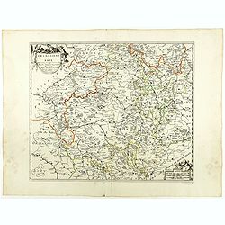
Champaigne et Brie etc.
A good engraved map of Champagne-Ardenne area, embellished with decorative title cartouche and scale cartouche with putti and surveying instruments. Paris, Metz, Reims, a...
- $150 / ≈ €140
Place & Date: Paris, ca. 1660
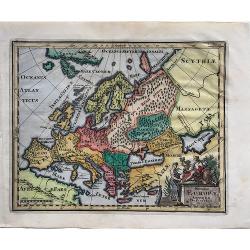
Summa Europae Antiquae descriptio.
A fascinating small map of Ancient Europe from Philipp Clüver's famous "Introductionis in Universam geographicam", which was first published in Leiden in 1624....
Place & Date: Amsterdam, 1697
Selling price: $120
Sold in 2022
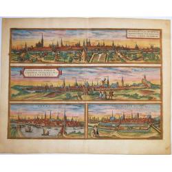
BRAUNSCHWEIG,BREMEN,STADE,LUENEBURG, - BRUNOPOLIS vulgo Brunsvicum . .LUNEBURGUM, Nobilis Saxoniae Urbs. . . BREMA . . .ALDENBURGUM Holsatiae.
A fine antique copper engraved sheet with four striking panoramic views by Braun and Hogenberg: Braunschweig, Luneburg, Bremen and Stade. From: 'Civitates Orbis Terrarum'...
Place & Date: Cologne, 1572
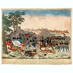
Bataille sur la rive droite de la Brenta. gagnée par les Français de 22 fructidor an 4. Bonaparte Général en chef. . .
Uncommon optical print showing the siege of Bassano in 1795, during the French Revolutionary Wars, in the territory of the Republic of Venice, between a French army under...
- $150 / ≈ €140
Place & Date: Paris, ca. 1795
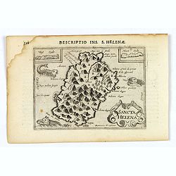
Sancta Helena.
An attractive small map of the south Atlantic island of St. Helena. Two years after the publication of Linschoten's Itinerario, the first map of St. Helena appeared in 15...
- $100 / ≈ €94
Place & Date: Amsterdam, 1606
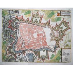
Cambrai.
Nice plan of Cambrai with all the fortification walls and fields around the city.
Place & Date: Paris 1696
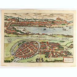
Flensburg and Itzehoe.
Flensburg: This view from the east of the harbour city at the end of the Flensburg Fjord shows the long merchants' yards that are typical of old Flensburg - front-gabled ...
Place & Date: Cologne, ca 1590
Selling price: $110
Sold in 2022
![[North America]](/uploads/cache/25907-250x250.jpg)
[North America]
Uncommon map of North America. The young United States incorporates the upper Midwest, with the remaining western territories of Louisiana, Nouveau Mexique, Nouveau Albio...
- $1000 / ≈ €936
Place & Date: Augsburg, ca. 1790
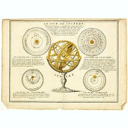
Le Nom de Systeme..
Showing the solar systems according to Copernicus, Ptolomy, Ticho Brahé and a composition. In the center a armillary sphere on a decorative base.
- $100 / ≈ €94
Place & Date: Paris, 1746
Widok Krakowa od Podgonza.
Bird's-eye view of Krakow city, with underneath the names of thirteen important buildings. Lithographed by J.Brydak after a photo by W. Rzewuskriego. Published by Czasu W...
- $750 / ≈ €702
Place & Date: Krakow, ca. 1865
![P.les dv Chili. P.les dv Perov. Carthagene. Royavme de Chile. [4 prints]](/uploads/cache/23571-250x250.jpg)
P.les dv Chili. P.les dv Perov. Carthagene. Royavme de Chile. [4 prints]
Group of 2 small maps and two costume plates of native people with a verdant landscape on the background.From the French text edition of Description d'Univers, 1683. by A...
Place & Date: Paris 1683
The Family Atlas Containing Eighty maps Constructed by Eminent Geographers. . .
Un unrecorded later edition of the S.D.U.K. Family atlas, with 80 plus one extra map. Most maps are single sheet but several are double page maps. Printed on heavy paper ...
Place & Date: London Edward Stanford, 1874
Pouching
Scarce, large early view of the city of Pouching, from the work "Gedenkwürdige Verrichtung Der Niederländischen Ost-Indischen Gesellschaft in dem Kaiserreich Taisi...
Place & Date: Amsterdam, 1675
![[Pirogues in the bay of the voyage of the Resolution. The Marquesas Islands ].](/uploads/cache/26373-250x250.jpg)
[Pirogues in the bay of the voyage of the Resolution. The Marquesas Islands ].
Aquatint depicting men in pirogues in the Bay of the Resolution from the Marquesas Islands engraved by Biasioli. Plate N° 91. HMS Resolution was a sloop of the Royal Nav...
- $50 / ≈ €47
Place & Date: Milan, 1827
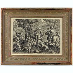
Sic leporem in laqueos agitnat per aperta fugacem - Gramina, siq canes rapidi sua terga sequutur
This is a plate from a series "Venationes ferarum, avium, piscium, pugnae bestiariorum & mutuae bestiarum". Published by Philippe Galle (Haarlem 1537 - 1612...
Place & Date: Antwerp, Philips Galle, ca 1596
![Le Roy de Navarra venant à Paris recheut le coup de cousteau au visaige par ung Pierre Chastel, lequel par quatre chevaulx fut tiré en pièces, faict le 27 de Decemb[re] l'an 1594.](/uploads/cache/38548-250x250.jpg)
Le Roy de Navarra venant à Paris recheut le coup de cousteau au visaige par ung Pierre Chastel, lequel par quatre chevaulx fut tiré en pièces, faict le 27 de Decemb[re] l'an 1594.
Engraved news-sheet with text in German and French. Pictorial reportage on the failed assassination attempt on King Henri IV of France by Jean Châtel (here identified as...
Place & Date: Cologne, ca. 1600
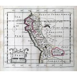
Peru.
A rare miniature map of Peru from John Seller's 'A New Systeme of Geography'. With a decorative cartouche.
Place & Date: London, 1690
![Carte du Tche-Kiang. [ Zhejiang province ]](/uploads/cache/30921-250x250.jpg)
Carte du Tche-Kiang. [ Zhejiang province ]
Map of Tche Kiang, prepared by Bishop Edmond-François Guierry, C.M. (Vicar Apostolic of Zhejiang, China) after sources supplied by missionaries. Published in "Les M...
Place & Date: Paris, 1874
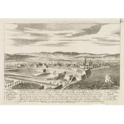
Mayence.
A very RARE panoramic town-view of the city of Mainz, including a numbered legend in both lower corners.The plate is numbered in black pencil in upper right corner.Publis...
Place & Date: Paris c.1720
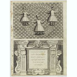
Turckschemoniken die onder den goddelycken. . .
Decorative picture of three dervishes dancers. Their whirling dance, also known as the sema, is a serious religious ritual performed by Muslim priests in a prayer trance ...
Place & Date: Antwerpen, Michiel Cnobbaert, 1673
Stendalia Stendel
Very decorative and rare panoramic town view of Stendal, Bez. Magdeburg.The engraver and publisher of prints, Mrs. Anna Beek of the Hague, enlarged the print and mounted ...
Place & Date: The Hague, ca. 1700

Les Gens de Justice. - Comme je vous ai bien dit vertement votre fait! . . .
Second state (of 2), with text. From "Les Gens de Justice". Text below image : - Comme je vous ai bien dit vertement votre fait! . . . - Mais aussi, je vous ai...
Place & Date: Paris, 1845-1848
![[Portrait] Johannes Baptista Homann . . .](/uploads/cache/36599-250x250.jpg)
[Portrait] Johannes Baptista Homann . . .
Stunning full portrait of the Imperial Geographer of the Holy Roman Empire, Johann Baptist Homann (1664-1724) who was born in the Bavarian town of Kammlach. Educated at a...
Place & Date: Nuremberg, c.1740
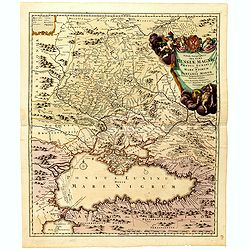
Tabula Geographica qua pars Russiae Magnae Pontus Euxinus seu Mare Nigrum et Tartaria Minor.
Homann's map is based upon the works of George von Mengden (1628-1702) a Livonian cartographer who worked for Peter the Great and Count Jacob Bruce [Graf Jakov Villimovic...
- $750 / ≈ €702
Place & Date: Nuremburg, after 1750
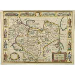
A newe mape of Tartary.
Early edition of one of the most decorative "carte à figures"- map of Tartary, known for its figured borders with costume figures, while above are vignettes of...
Place & Date: London, 1627

Folies Bergere - Folies de Paris. La revue de Hélène Martin . . .
Original advertising poster for Les Folies Bergère cabaret in Paris. The Théâtre des Folies Bergère is a famous Parisian performance hall inaugurated on May 2, 1869 a...
Place & Date: Paris, ca. 1977
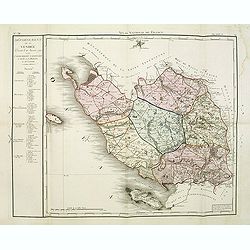
Département de la Vendée decreté le 26 janvier 1790. . .
Map of region of west of France. Region of Vendée divided into 6 districts. On the left the title with underneath a large explicative text with the division of the distr...
Place & Date: Paris, 1790-1818
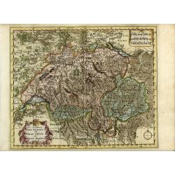
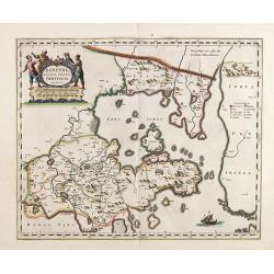
Les Cantons des Suisses, et Leurs Alliez et Leurs Sujets.
This finely engraved map dramatically illustrates the mountainous terrain of Switzerland. It is embellished with decorative title and distance scale cartouche and a simpl...
Place & Date: Amsterdam, 1700
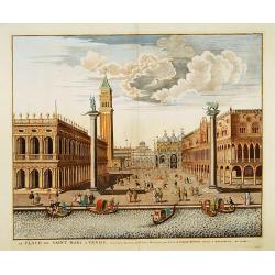
La Place de Saint Marc a Venise.
A very attractive Town plan of the place St Marc in Venice.Joan Blaeu published during his life three town-books of Italy: Citta del Vaticano, Rome and Napoli. By the yea...
Place & Date: Amsterdam, 1705
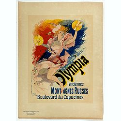
Olympia anciennes montagnes Russes.
Chromo lithographed poster, "Olympia anciennes montagnes Russes.", by CHERET, J. Plate 133, published in Maître 17, on April 1898. The "Les Maîtres de l'...
Place & Date: Paris, Imprimerie Chaix, April 1898
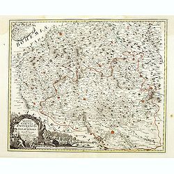
Marchionatus Moraviae circuli Znoymensis et Iglaviensis. . .
Map of the Znaym region of Moravia, the southern part of the Czech Republic, with figurative cartouche and small table of explanations. After Johann Christoph Müller pub...
- $250 / ≈ €234
Place & Date: Nuremberg, 1750
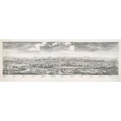
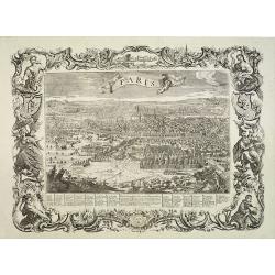
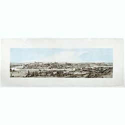
Paris.
A spectacular panoramic view of Paris, with legends numbered from 1-70 in French. With the title in a banderol.After a design by Friedrich Bernhard Werner (1690-1776) who...
Place & Date: Augsburg, ca. 1740
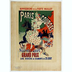
Hippodrome de la porte Maillot. Paris Courses.
Chromo lithographed mini poster, " Hippodrome de la porte Maillot. Paris Courses. Pelouse 1 f. pesage 2 f. Nouveau sport. Grand prix : une rivière en diamants de 20...
Place & Date: Paris, Imprimerie Chaix, April 1897

5e Vue d'Optique Representant La Vue interieure de la Cathedralle de St. Paul de Londres.
So-called optical print illustrating a perspective view of the interior of the Saint Paul cathedral in London. Engraved by la Marcade.In the eighteenth and nineteenth cen...
Place & Date: Paris, 1760
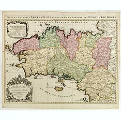
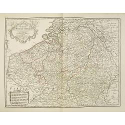
La Bretagne Divisée en ses neuf Eveschés : qui font aussi l'estendue des Receptes de la Généralité de Nantes Dediée a Monseigneur Monseigneur de Ponchartrain. . .
Stunning map of Brittany prepared by Hubert Jaillot of Paris, and published by Pierre Mortier, in his Atlas Francois in 1696.A rare edition, without date! It shows the pr...
Place & Date: Paris, 1694
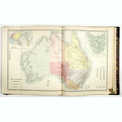
![[Set of World and 5 continents - 7 maps ].](/uploads/cache/44957-250x250.jpg)
[Set of World and 5 continents - 7 maps ].
One of the last decorative maps of the 19th century. In side panels representations of the four seasons, figures, local scenes. World map, Europe, Asia, North America, Af...
Place & Date: Paris, 1850
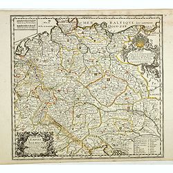
Carte de L'Empire d'Alemagne par P. Duval. . .
Uncommon map of Germany and the eastern part of Poland. In upper right corner a dedicational cartouche with coat of arms and dedication to Saint-Laurens.
Place & Date: Paris, 1676
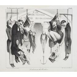
Les honneurs du Panthéon . . . . (Plate 433 from La Caricature.)
On the front wall is written: "To the great men and women, our country is grateful". This lithograph shows people hanging in front of the Panthéon, and may be ...
Place & Date: Paris, October 23, 1834
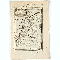
Provinces Unies.
A charming map of The Netherlands. Title in curtain draped at top. French text on verso.From the original 1683 text edition of "Description d'Univers. . ." by A...
Place & Date: Paris, 1683
Selling price: $1
Sold in 2023
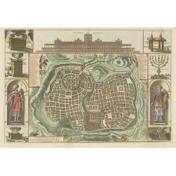
Jerusalem.
Engraved by Bastiaan Stoopendaal from Juan Bautista Villapando's imaginary town-plan of Jerusalem. This bird's-eye view is surrounded by 12 scenes, views and portraits of...
Place & Date: Amsterdam, 1682
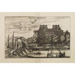
Magazin de la Compagnie Occidentale. - Het West Indisch Huys.
A decorative print of the West Indian House , the headquarters of the W.I.C., a place for meeting, trading and storage of spices and ship equipment. The maps and charts w...
Place & Date: Amsterdam, J. van Meurs, 1663
Selling price: $350
Sold in 2023
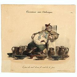
Caricature anti-cholérique La peur du mal donne le mal de la peur. (pl 1)
Caricature on hypochondria and protective measures against cholera. An overweight man seated in a chair surrounded by pitchers and bowls. In 1832, there was a devastating...
Place & Date: Paris, ca. 1830
Carta terza Generale del' Asia.
Rare first state of this important chart showing part of the north coast of New Guinea and islands of the Pacific Ocean. To the north of Japan the landmass of Isola di Ie...
Place & Date: Florence, 1646
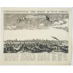
Constantinopolitanae urbis effigies ad vivum expressa.
A rare panoramic town-view of Istanbul with over the whole length of the lower part 3 columns of poems in Latin, Dutch and French and a numbered key 1-29 to the principal...
Place & Date: Amsterdam, 1660
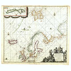
Pascarte van Europa Beginnende vande Canael tot aen Spitbergen, en van Ysland tot aen Nova Zemla . . .
An eye-catching chart of northern Europe with a coastline from northern Russia to the Dutch English Channel in the south. Good detail on Iceland. North to the top.In the ...
Place & Date: Amsterdam, after 1666
Carte Des Pays Bas Catholiques Dressée. . .
Topographically detailed map of the southern part of the Low Countries that extends from Paris to Metz and north into Holland. Details include roads towns and villages. T...
Place & Date: Paris, 1780
Funeral in China.
A scene of a funeral in China from Linschoten's famous voyages to the East of 1583-92 here published by De Bry the year after they first appeared as a separate book. From...
Place & Date: Frankfurt, 1599
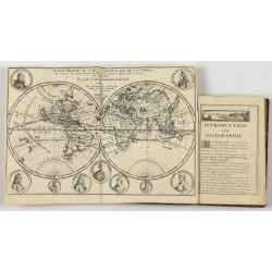
Introduction a la Geographie..
Second edition of this charming travel compendium illustrated with a fine world map in two hemispheres prepared by de l'Isle. California as an island. The hemispheres are...
- $2000 / ≈ €1871
Place & Date: Paris, 1717
Xantung, sinarum imperii provincia quatra.
A map of the northern province ‘Xantung’ of China after the Jesuit Martino Martini.Shows the Great Wall and is centered on the Bohai Sea, and the Shandong and Liaonin...
Place & Date: Amsterdam, ca 1660
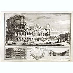
Prospetto dell'anfiteatro Flavio . . . / Prospetto di Tutto l'Anfiteatro intiero . . . / Pianta dell' divisa nelli suoi / Spaccato, e veduta interiore dell' Anfiteatro.
Monumental engraving showing the Colloseum in Rome, in its setting, with below a ground-plan and elevation. Engraved and drawn by Alessandro Specchi (1668-1729), an engra...
Place & Date: Rome, 1703
![[Anti capitalism Soviet Union propaganda poster]](/uploads/cache/47035-250x250.jpg)
[Anti capitalism Soviet Union propaganda poster]
Propaganda mini anti-capitalism poster published in Russia during The Cold War. By the 1960’s and 1970’s, outrageous practices in Soviet bureaucracy flourished. Poor ...
Place & Date: Leningrad, 1974
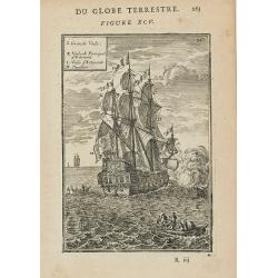
(Des Galeres - Shipping scene)
Miniature view of a vessel, showing the various types of sails. With key list in upper left corner.From the French text edition of Description d'Univers.. (5 volumes), 16...
Place & Date: Paris, 1683
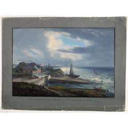
Vue de Gattweick et de l'embouchure du Rhin, dans la Mer du Nord.
Very decorative view of Katwijk. Signed lower right, Louis Bleuler au chateau de Laufen . Original design by Louis Bleuer. This gouache was the model for his aquatint in ...
Place & Date: 1820
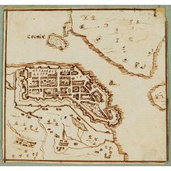
Cochin (today: Ernakulam)
Small but charming 18th water color on paper depicting Cochin (today : Ernakulam) was from 1500, when the first Portuguese fleet called on its port, a firm ally of the Po...
Place & Date: India? c.1750
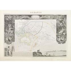
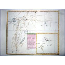
Océanie.
A very decorative 19th century map of the Pacific Ocean, with hand colored lines indicating the extent of Polynesia, Micronesia, Melanesia, and Malaysia (or Southeast Asi...
Place & Date: Paris, 1850
Milan. Ville forte, Capitale du Duché de même nom, l'une des plus grandes des des plus considérables de l'Italie.
A very decorative and extremely rare of Milan, including a numbered key ( 1-35 ) in lower part. Published by Jacques Chéreau, (1688 - 1776). Engraved by Aveline and fir...
- $3500 / ≈ €3275
Place & Date: Paris, ca.1750
Tabula Asiae IIII. (Cyprus, Holy Land, Syria, Jordan, Iraq)
Gastaldi's map showing Cyprus, the Holy Land, Syria, Jordan and Iraq, based upon Ptolemy's map It is one of the earliest obtainable maps of the region.From Giacomo Gastal...
- $350 / ≈ €328
Place & Date: Venice, 1548