Wish List
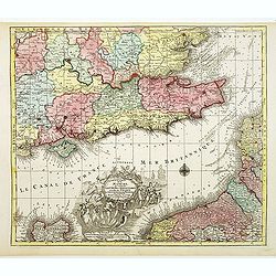
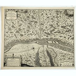
La plus grande partie de la Manche, qui contient les Côtes d'Angleterre?
Wonderful folio sheet map of the English Channel. With a large decorative vignette cartouche which includes Neptune and his sea horses, Apollo, a sailing ship, and other ...
Place & Date: Augsburg, 1770
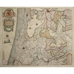
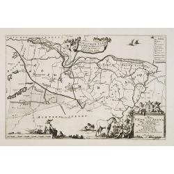
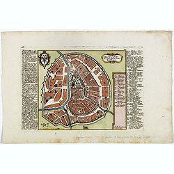
Rhenolandiae et Amstellandiae.
Beautiful map of the region between Haarlem, Amsterdam and Gouda. Bottom left corner signed : Exc Guilj Blaeuw. Dutch text on verso.
Place & Date: Amsterdam, 1642
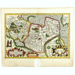
Tartaria.
Published in Hondius' editions of the Mercator Atlas from 1606 onwards, showing China, Korea as an island, and the northern Pacific coast of America showing the two conti...
Place & Date: Amsterdam, 1633
Henna ardera deel. De vijfde Grietenije van de Wester goo. . .
Very detailed map of "Henna ardera deel. De vijfde Grietenije van de Wester goo" in Friesland prepared by Bernardus Schotanus Steringa. With decorative title ca...
Place & Date: Leeuwarden, 1718
![[JAPAN] SUCCESSION DES EMPEREURS DU JAPON AVEC. . .](/uploads/cache/84722-250x250.jpg)
[JAPAN] SUCCESSION DES EMPEREURS DU JAPON AVEC. . .
This is an interesting and decorative folio sheet containing a small (4.5 x 6.2") map of Japan, titled Carte du Japon, and two larger engravings derived from Montanu...
Place & Date: Amsterdam, 1719

By the Dawn's Early Light.
Original 1940's WW II American liberation poster by Natacha Carlu, published by the French Press & Information Service, New York, N. Y.The poster shows a torch-bearin...
Place & Date: New York, French press and information service, 1945
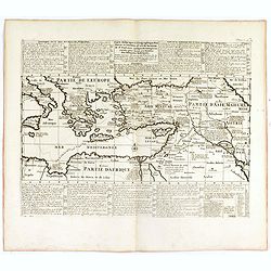
Carte historique et géographique pour servir à l'Histoire Sainte et à la Vocation de Saint Paul, avec quelques remarques curieuses pour servir à l'Histoire des Antiquités judaïques.
Interesting sheet with a map of the travels of Saint Paul, including eastern part of Europe, Asian continent and part of north Africa, with descriptive French text, from ...
Place & Date: Amsterdam, 1728
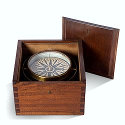
Early 19th century magnetic dry card compass with wooden bowl,
Brass dry rose marine compass, in its mahogany case. The mariner's compass, which enabled mariners to know the direction in which they were sailing, has always been one o...
Place & Date: ca. 1800
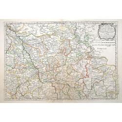
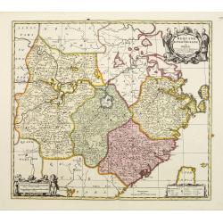
Generalis Lotharingia ducatus tabula. . .
Detailed and decorative map centered on Metz, Nancy.
Place & Date: Amsterdam, 1670
Estats de la Succession de Cleves et Iuliers : Mayence..
"Covering southern part of the river Rhine including Cologne, Trier, Paderborn, Bamberg and Nuremberg, etc. Engraved by R.Cordier Abbauil. Nicolas Sanson was to brin...
Place & Date: Paris 1648
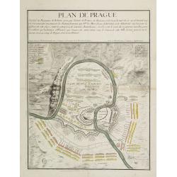
Plan de Prague.
Rare and separately published plan of Prague published by Joan Baptista Nolin with the address à l'enseigne de la Place des Victoires et chez le Sr. Humblot rue St. Jacq...
Place & Date: Paris, ca. 1742
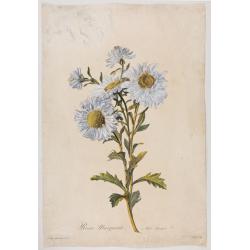
Reine-Marguerite. Aster chinensis. L.
A bouquet of flowers. Engraved by P.F. Le Grand after designs by the Dutch-born Gerard van Spaendonck (1746-1822).Taken from the rare work "Fleurs dessinées d'aprè...
Place & Date: Paris, ca. 1800
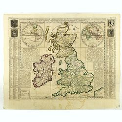
Nouvelle carte d'Angleterre, d'Ecosse et d'Irlande, avec des instructions ..
Striking large folding map of the British Isles, with large insets of the Eastern and Western Hemispheres and the coats of arms for England, Ireland, Scotland and Wales. ...
- $200 / ≈ €187
Place & Date: Amsterdam, 1721
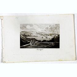
Sewastopol. (Sebastopol)
View of Sebastopol. Engraved by Leopold Zechmayer who was active in Vienna.
- $20 / ≈ €19
Place & Date: Vienna, ca. 1835
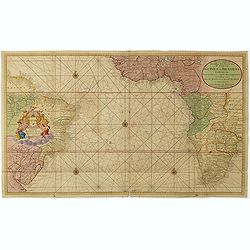
Nieuwe Wassende Graadige Pas-kaart van de Kust van Guinea en Brasilia.
Rare two-sheet sea chart of the coasts of Brazil, West Africa and South Africa, published by Johannes Van Keulen (the younger), circa 1720.The chart shows the western coa...
Place & Date: Amsterdam, 1751
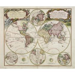
Planiglobii Terrestris - Mappe-Monde...
Word map in double hemisphere. In center two smaller hemispheres of the north and south pole are shown. Two interesting diagrams depict the earth as it would be seen from...
Place & Date: Nuremberg, 1746
Nouveau Plan Routier de la Ville et Faubourgs de Paris // Avec ses principaux Edifices et Nouvelles Barrieres.
Decorative wall map of Paris, published by M. P|chon in Paris and engraved by Michel Glot. The plan is framed by a floral border and there are 27 Parisian views of places...
Place & Date: Paris, 1834
Gezicht van het Admiraliteits-Magazyn en Scheeps Timmerwerf.
Formerly the V.O.C. warehouse and arsenal for the Admiralty of Amsterdam, now-a-days the Scheepvaartmuseum (Maritime Museum). Taken from the "Atlas of Amsterdam"...
Place & Date: Amsterdam, 1780
Walachia, Servia, Bulgaria, Romania.
The cartographer of this map was Gerard Mercator. Latin text on verso.The scale of longitude and latitude are colored alternating with red, blue and pink. The cartouches ...
Place & Date: Amsterdam, 1647
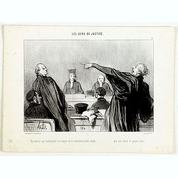
Les Gens de Justice. - Un avocat qui éviemment est rempli de la conviction la plus intime . . .
Second state (of 2), with text. From "Les Gens de Justice". Text below image : - Un avocat qui éviemment est rempli de la conviction la plus intime . . . que s...
Place & Date: Paris, 1845-1848
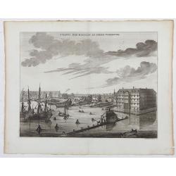
s'Lants Zee-Magazyn en Scheeps Timmer-werf.
Decorative view of the back yard of the formerly the V.O.C. warehouse and arsenal for the Admiralty of Amsterdam, now-a-days the Scheepvaartmuseum (Maritime Museum).The p...
Place & Date: Amsterdam, 1694
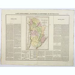
Carte Geographique, Statistique et Historique de Buenos-Ayres.
A nice detailed map of what is today northern Argentina (Rep. of Buenos Ayres or the United Provinces of South America) from Buchon's Atlas Gégraphique Statistique, hist...
Place & Date: Paris, 1825
Kollumer land En het Nieuw Kruys land de vijfde gritenije van Oostergoo . . .
Very detailed map of "Kollumer land En het Nieuw Kruys land de vijfde gritenije van Oostergoo" in Friesland prepared by Bernardus Schotanus Steringa. Centered o...
Place & Date: Leeuwarden, F. Halma, 1718

(Art déco gouache)
Outstanding "art deco" gouache (unsigned) from the workshop of "Robert Pichon. Ateliers de Dessin et Lithographie – 10, rue Rochechouart – Paris. The g...
Place & Date: Paris, ca. 1930
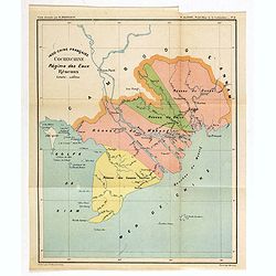
Indo-Chine Française Cochinchine. Régime des Eaux Réseaux.
Charming map of the southern third of current Vietnam whose principal city is Saigon or Prey Nokor in Khmer. It was a French colony from 1862 to 1954.Prepared by R.Brissa...
- $150 / ≈ €140
Place & Date: Saigon, Librairie Brunet. c.1920
Huquang, Kiangsi, Chekiang ac Fokien.
A reissue of Janssonius' map of south east China, with wash color and uncolored cartouches.The map is based on the maps of Martin Martini, themselves based on Chinese sou...
Place & Date: Amsterdam, 1720
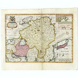
A New Map of Great Tartary and China with the adjoining parts of Asia...
Two insets showing the land to the north-east of China according to the Jesuits. Map stretches from northern Russia and Nova Zemlya in the north-west to Formosa in the so...
- $650 / ≈ €608
Place & Date: Oxford, 1700
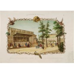
Rotterdamse Diergaarde. . .
Decorative view of Zoo of Rotterdam. To the right the house of the manager of the zoo. Decorated with personages in typical dress watching lions.
Place & Date: Amsterdam, 1860
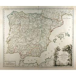
Carte des royaumes d\'Espagne et de Portugal ...
This map, from Robert de Vaugondy's "Atlas Universel", illustrates the major postal routes throughout the Iberian Peninsula. One of the earliest obtainable maps...
Place & Date: Paris, 1757
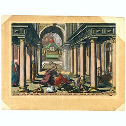
Domus mea domus orationis vocabitur. Joan 10.
A superb example of this illustration from Memorabilium Novi Testamenti in templo gestorum (Events in and around the Temple) (Events in and around the Temple). Christ exp...
Place & Date: Antwerp, 1585
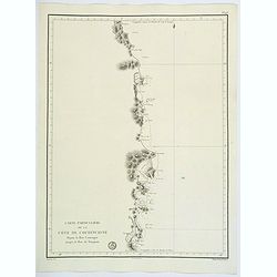
![[Lot of 11 maps of the Strait of Magellan] Carte du detroit de Magellan avec les Routes de la Bodeuse et de l'Etoile.](/uploads/cache/19991-(3)-250x250.jpg)
[Lot of 11 maps of the Strait of Magellan] Carte du detroit de Magellan avec les Routes de la Bodeuse et de l'Etoile.
Carte du Detroit de Magellan avec les Routes de la Bodeuse et de l'Etoile taken by the French discoverer Comte de Bougainvile, L.A. With in addition 10 maps / prints of...
Place & Date: Paris, c. 1790
Selling price: $258
Sold in 2022
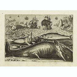
Virulus marinus. Cete (Whale and whaling scene)
Whale and whaling scene, set against a mountainous landscape in the manner of Pieter Brueghel the Elder. Plate number 1. The engraving is copied after Adrian Collaert pla...
Place & Date: Antwerp, after 1598
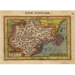
Siena.
Miniature map of the Siena in Italy, with major cities named. Strapwork title cartouche at the bottom. Sea is stipple engraved. Latin text on verso.
Place & Date: Antwerp 1609
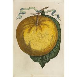
Aurantium Maximum.
Decorative engraving representing a citrus fruit. Taken from the book "Hesperides sive de malorum aureorum" by Giovan Battista Ferrari (Italian botanist, 1584-1...
Place & Date: Rome, Scheus, 1646
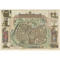
Jerusalem.
Engraved by Bastiaan Stoopendaal from Juan Bautista Villapando's imaginary town-plan of Jerusalem. This bird's-eye view is surrounded by 12 scenes, views and portraits of...
Place & Date: Amsterdam, 1682

Nobiolo Canavesano, o uva Spanal.
Highly decorative stipple engraving with hand-colored details from a scarce work 'Pomona Italiana ossia Trattato Degli Alberi Fruttiferi' by Giorgio Gallesio. The series ...
Place & Date: Turin, 1832
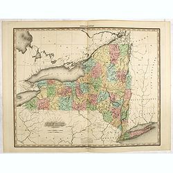
New York by H.S. Tanner.
A very fine example of the revised 1825 issue of Henry Schenk Tanner's important map of New York, with significant changes to the mapping. Published in his "New Amer...
Place & Date: Philadelphia, Henry Tanner, 1825

Toujours des sangsues!
Lithograph depicting a corpulent physician diagnoses more leeches for a young woman, who lies drained. In 1832, there was a devastating cholera epidemic in Paris.Publishe...
Place & Date: Paris, c. 1832
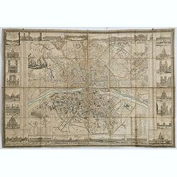
Lutece ou Premier Plan de la Ville de Paris Tiré de Cesar . . .
Paris est nommée Lutetia par les Romains, et se limite à l’île de la Cité avec ses maisons de forme ronde, bâties de bois et de terre, et couvertes de roseaux ou d...
- $200 / ≈ €187
Place & Date: Paris, 1728
![[Title page] Voyage pittoresque et archaéologique en Russie.](/uploads/cache/43490-250x250.jpg)
[Title page] Voyage pittoresque et archaéologique en Russie.
Title page of "Voyage pittoresque et archaéologique en Russie" with two joined pages. The first is a letter for a certain "Mathilde" from Anatole Dé...
Place & Date: Paris, 1844
Selling price: $100
Sold in 2021
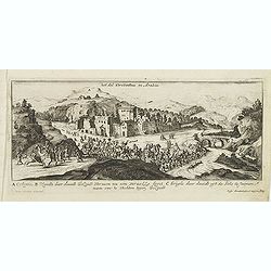
Het dal Terebinthus in Arabia.
Magnificent bird's eye- of Terebinthus north of Hebron. Etched by Gaspar Bouttats (1640-1695).The Antwerp-based publisher Jacques Peeters published ca. 1690 a series of p...
- $150 / ≈ €140
Place & Date: Antwerp, c.1690
Moscow des Grossen Zaars Residenz.
A detailed plan of Moscow with an extensive description of the town and a numbered key 1-49 identifying important places. A coat of arms in the left corner.Afterwards, t...
- $400 / ≈ €374
Place & Date: Augsburg, 1730
![[Two vomlumes, with two Leo maps] De Bello Belgico, Decas Prima / Decas Secunda.](/uploads/cache/48779-250x250.jpg)
[Two vomlumes, with two Leo maps] De Bello Belgico, Decas Prima / Decas Secunda.
With 2 engraved titles of the 'Leo Belgicus', with one paw resting on a shield bearing the title, large woodcut printer's device on the colophons, and 30 richly engraved ...
Place & Date: Rome, Franciscus Corbelletus, 1632-1647
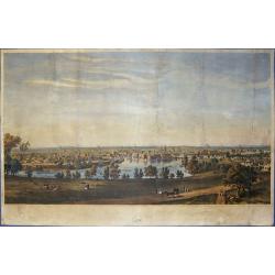
Lowell Mass.
Splendorous and very decorative total view of the city of Lowell at the Merrimack River in Massachusetts.
Place & Date: New York, 1856
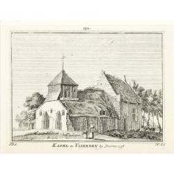
Kapel van Vlierden.
Etching of the old chapel of Vlierden (near Deurne), from Het Verheerlijkt Nederland of Kabinet van hedendaagsche gezichten.. published by Isaac Tirion in Amsterdam. Etch...
- $80 / ≈ €75
Place & Date: Amsterdam 1745-1774
![Dunkirk,Gravelines,Bourbourg. - Duynkercke [on sheet with] Grevelinge [and] Borborch.](/uploads/cache/85894-250x250.jpg)
Dunkirk,Gravelines,Bourbourg. - Duynkercke [on sheet with] Grevelinge [and] Borborch.
Fine antique copper engraved sheet with one panorama of Dunkirk and other two bird's-eye views by Braun and Hogenberg: Dunkerque, Gravelines and Bourbourg from the second...
Place & Date: Cologne, 1575

Erfolgte Kapitulation zwischen dem General Bonaparte und den Gross Leister von Malta. Vor der Hauptstadt Walette zu Maltha, am 10 Juni 1798.
Copper engraving with three scenes and one portrait on one sheet. In upper a view of Bonaparte arriving at Valletta. Published in "Allgemeine Welt-Chronik oder neue ...
Place & Date: Zittau, 1798-1800

DANSEUSE. Costumes Persans 9.
A beautiful hand colored lithograph of an elegant dancing girl from Persia published in the French work "Galerie Royale de Costumes peints d´après nature par diver...
Place & Date: Paris, Chez Aubert & Cie., 1842-1848
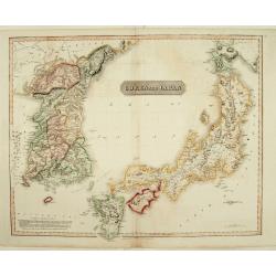
Corea and Japan.
A fine large-scale map of Japan and Korea showing an increasingly refined outline to the Japanese islands but still oversized Korean peninsula. The strait south of Korea,...
Place & Date: Edinburgh, 1816
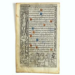
Leaf on vellum from a printed Book of Hours.
21 lines of printed text, surrounded by Renaissance borders decorated with flowers and little miniatures with figures on both sides.From the press of the leading Parisian...
Place & Date: Paris, Germain Hardouyn, c. 1520-1540
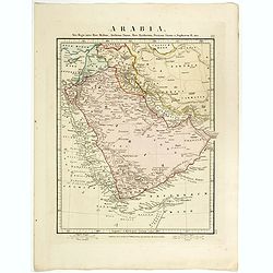
Arabia.
Steel engraved map of the Arabian Peninsular. It shows Arabia and Parts of Persia, Syria and Kurdistan. The regional boundaries are colored and relief shown by hachures. ...
Place & Date: London, 1841
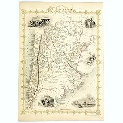
Chili and La Plata.
A nice decorative and detailed map of the region, depicting mountains, rivers, towns, islands, etc, imaginatively adorned with lovely small vignettes of a 'Travelling Pos...
Place & Date: London, 1851
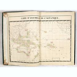
Atlas Universel de Géographie. Sixième partie - Océanique.
Volume 6 including detailed maps of Australia, New Zealand, Hawaii, Pacific islands, Indonesia and 3 maps of the Philippines. With title page and one general map.Supporte...
Place & Date: Brussels 1827
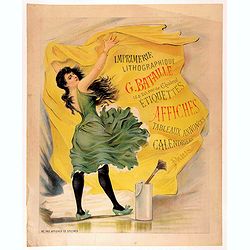
Imprimerie lithographique G. BATAILLE 18&20 rue de Chabrol - Etiquettes affiches tableaux annonces calendriers Paris.
Chromolithograph poster for a French printing company named Bataille, and printed by the company itself. The poster depicts a woman with a green dress, sticking a poster ...
- $1500 / ≈ €1404
Place & Date: Paris, 1895
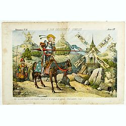
Il Don Cihsciotte a complici. Papagallo No. 48. Anno VI.
Taken from the Italian satirical newspaper Il Papagallo, a satirical magazine founded in January 1873 by Augusto Grossi (1835-1919), which specialized in color-printed ca...
Place & Date: Bologne, 1878
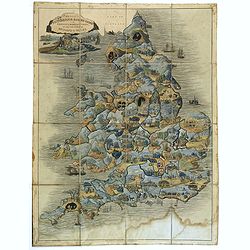
Wallis's Round Game of the Produce and Manufactures of the Counties of England and Wales.
Wallis's Picturesque Round Game of the Produce and Manufactures of the Counties of England and Wales was first published between 1826 and 1837 according to F.R.B. Whiteho...
Place & Date: London, 1826-1837
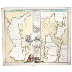
Caspian Sea+Kamtchatka.-Geographica Nova... MARE CASPIUM altera Kamtzadaliam seu Terram Jedso curiote exhibet.
A decorative pair of maps on one sheet, depicting then recent discovery, focusing on the Caspian Sea and Northeastern Russia and Kamtchatka.
Place & Date: Nuremberg, 1730
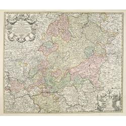
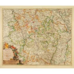
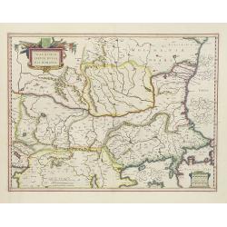
S.R.I Pars septentrionalior superioris Circuli Rhenani. . .
Detailed map centered on central Germany, including the towns of Frankfurt, Mainz, Coblenz, Nassau, Waldek, Cassel, Eisenach, Erfurt, Hirschfield, Fuld, Schweinfurt, Bamb...
Place & Date: Amsterdam, 1720
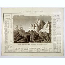
Carte des Principales Montagnes du Globe.
A nice detailed depiction of the principal mountains of the world from Buchon's Atlas Gégraphique Statistique, historique et chronologique des deux Ameriques et des isle...
Place & Date: Paris, 1825
Carte Particuliere de la Cote de Cochinchine Depuis la baie Camraigne jusqu'a le baie de Tamquam.
A basic coastal sea chart of a part of French Indochina (Vietnam) from Cap Varella and Cam Ranh Bay in the south, northward past Nha Trang, Hen Kohe Bay, on to Phu-yen Ba...
Place & Date: Paris ca 1780
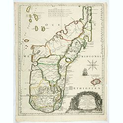
Isle D'Auphine, communement Nommée pae les Europeens Madagascar. . .
One of the most UpToDate maps of Madagascar, also showing the Comoros Islands in the North West and the Reunion Island in the South East.With decorative title cartouche r...
- $900 / ≈ €842
Place & Date: Paris, 1667
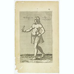
Fille Moresque esclave en Alger ville de Barbarie. (63)
Sought-after copper engraved plate of a young slave from Algeria. Plate from Laonikos Chalcocondyle’s "L'histoire de la décadence de l'empire grec et establisseme...
- $45 / ≈ €42
Place & Date: Paris, Mathieu Guillemot, 1650
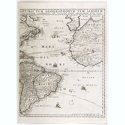
(Totius Americae nova et exacta tabula ex) optimis tum geographorum tum aliorum scriptis collecta et ad hodiernam regnorum principatuum et maiorum partium distinctionem accomodata.
Eastern part of a two-sheet map of America, with attribution to Willem Blaeu. According to Philip Burden, the map was derived from Cornelius Danckert's 1647 map of the sa...
Place & Date: Rome, 1679
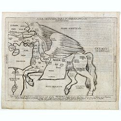
Asia secunda pars in forma Pegasi.
UNRECORDED PLATE or STATE. Asia depicted as the flying horse Pegasus. Below the depiction 3 lines of engraved Latin text. Double page copper engraved map from Heinrich B�...
Place & Date: Brunswick, ca. 1635
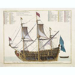
Coupe dun Amiral de 104 pieces de Canon avec ses principales proportions et les noms des pieces du dedans.
Fine double-page engraved plate of a naval vessel. Etched by Jan van Vianen. From Mortier's "Neptune François". From Mortier's famous maritime Atlas "Nept...
Place & Date: Amsterdam, 1695
Selling price: $925
Sold in 2023
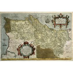
Portugalliae Que Olim Lusitania, novissima et exactissima Descriptio (...)
A beautiful and old colored folio-format engraving of the Kingdom of Portugal by Abraham Ortelius. Is composed by the extremely rare Alavaraz Secco map published by Miche...
Place & Date: Antwerp, 1573
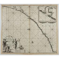
Paskaart van de kust van Maroca beginnende van Larache tot aan C. Cantin. . .
A nautical sea chart of the coast of Morocco. Insert at top right: 'Nieuwe Afbeelding van de Rivier Rio Rebata in 't Groot".Bottom right: chart number '32'. Compass ...
Place & Date: Amsterdam, ca.1682
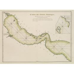
Carte du Golfe Persique depuis Bassora jusqu'au Cap Rasalgate.
French chart of Gulf of Persia with the coast of Saudi Arabia, U.A.Emirates and the coast of Northern Oman. In the upper corner coast of Kuwait, coast of Iran in upper pa...
Place & Date: Paris, ca 1775
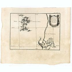
Carte des Iles de Ponghou suivant le point sur lequel ont été faites les cartes de la Chine et de la Tartarie par l'ordre et aux frais de l'empereur. . .
Plan of the West coast of Taiwan and it direct environs. From "Lettres Édifiantes et Curieuses. . Missionaires de la Compagnie de Jesus [Jesuit Letters]". Engr...
- $175 / ≈ €164
Place & Date: Paris, 1780-1783
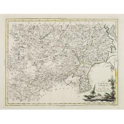
La Tartaria Chinese.
With decorative title cartouche. Covering north eastern part of China, with good detail in Korea and a curious shape for Hokkaido (here called Jeso-Gasima ).Engraved by G...
Place & Date: Venice, 1784
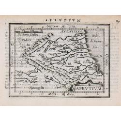
Aprutium.
Miniature map of a part of Italy, with major cities named. Strapwork title cartouche. Latin text on verso.
Place & Date: Antwerp, 1601
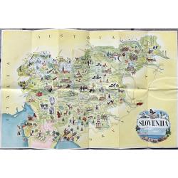
Slovenija - Jugoslavija
A fine tourist pictorial map of Slovenia. On the backside with a map showing roads and railroads. Also text information in english, french and german.
Place & Date: Ljubljana, 1954
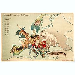
Mappa Humoristico da Europa.
A really unusual and lovely map, published in Portugal at the outbreak of The Great War in 1914. This outbreak of war in Europe was the result of a complex sequence of ev...
Place & Date: Lisbon, 1914
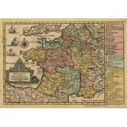
Reise Charte durch Franckreich.
Finely engraved map of France, with a nice cartouche and ships in the sea.
Place & Date: Augsburg, 1789
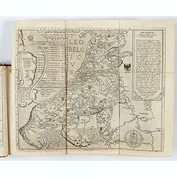
Novus de Leone Belgico eiusq topographia atq. Historica descriptione liber (…). Rerumque in Belgio maxime gestarum, inde ab anno Christi M.D.LIX. Usque ad annum M.D.LXXXVII perpetua narratione continatus.
ENLARGED EDITION, with 207 (of 208) engravings of a famous eyewitness account of the Dutch Revolt, with the famous "Leo Belgicus" map, here in its second state...
Place & Date: Cologne, Gerardus Campensis for Frans Hogenberg, 1588
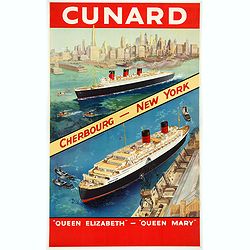
Cunard Cherbourg-New York.
Original vintage Cunard luxury cruise liner travel poster advertising Cunard Europe to all America fastest ocean service in the world. Stunning design featuring two color...
Place & Date: England, ca. 1930
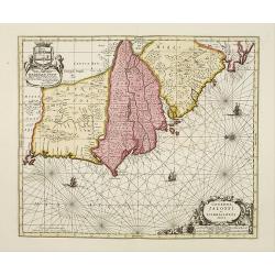
Genehoa Jaloffi et Sierraliones regna.
Decorative and detailed map of the West African Coast, from Senegal to Sierra Leone. In the center the river Gambia to the mouth in the Atlantic. Upper left a dedication ...
Place & Date: Amsterdam, 1670 / 1720
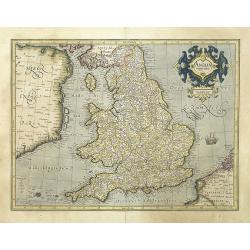
Anglia regnum.
Counties are shown in outline and named. The coast of Ireland is shown across the Irish Sea.Mercator was born in Rupelmonde in Flanders and studied in Louvain under Gemma...
Place & Date: Amsterdam, 1630
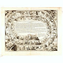
Regles invariables du jeu mythologique du Phenix. . .
Mythological Game of the Phoenix . Printed board game called 'Mythological Game of the Phoenix'. Game consisting of 63 squares arranged in a spiral with the rules in the ...
Place & Date: Paris, ca. 1810
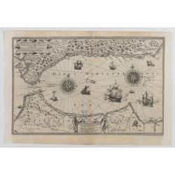
Hydrograhica descriptio
This very rare chart is important as the first printed sea chart of the Mediterranean coast of Spain, Gibraltar, also depicting the northern coast of Marocco.Willem Bar...
Place & Date: Amsterdam, W.Blaeu, 1612