Search Listings matching "ukraine"
![[Europe, Eastern, Sarmatia, Ukraine]](/uploads/cache/33854-250x250.jpg)
[Europe, Eastern, Sarmatia, Ukraine]
Wood block printed map and one of the earliest printed representations of European Sarmatia, generally the region between the Baltic and Black Sea and Sea of Azov. Includ...
Date: Vienna, Trechsel, G., 1525 -1541
![.[Georgia (Republic), Sarmatia, Ukraine]](/uploads/cache/33870-250x250.jpg)
.[Georgia (Republic), Sarmatia, Ukraine]
Wood block printed map and one of earliest printed representation of Georgia (Republic), Sarmatia, Ukraine prepared by Martin Waldseemüller. Based on the slightly larger...
Date: Vienna, Trechsel, G., 1525 -1541
French composite atlas made up of rare maps published by Parisian editors from the 17th century , mainly by G. Jollain including scarce maps of America.
A rare French composite atlas including 90 maps, published by Parisian publishers from the 17th century, mainly by Gérard I Jollain, or by maps bought from Dutch publish...
Date: Paris, ca. 1675
A unique composite atlas with updated Porro maps.
Unique composite atlas containing in total 84 maps - 82 maps engraved by Girolamo Porro and heavenly reworked around 1686 and 2 newly engraved maps; Piccola Tartaria (Cr...
Date: Venice, 1686
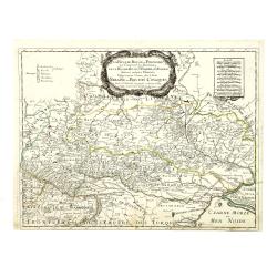
LA RUSSIE ROUGE ou POLONOISE qui Comprend les PROVINCES DE LA RUSSIE ROUGE de VOLHYNIE et de PODOLIE divisées en leurs Palatinats Vulgairement Connües sous le Nom D'VKRAINE ou PAYS DES COSAQUES.
A very rare Sanson map of Ukraine and so-called Russie Rouge, stretching from Lublin in the west to Kherson Oblast in the east (here called "Confin de La Petite Tart...
Date: Paris, 1706
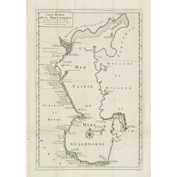
Carte Marine De La Mer Caspiene levée suivant les ordres de S.M.Cz. En 1719, 1720 et 1721.
Detailed of the Caspian Sea, prepared by Karl van Verden in 1722. Van Verden was a Russian sailor and the Czar's Special Commander, who produced the first accurate map of...
Date: Paris, ca. 1725
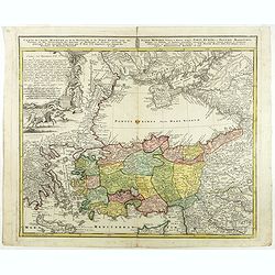
Carte de l'Asie Minevre ou de la Natolie et du Pont Euxin...
A map centered on the Black Sea and the geographical regions surrounding it. The map shows Asia Minor, Crete, Cyprus, northern Syria, Iraq, Georgia, Crimea, Bulgaria, Rom...
Date: Nuremberg, 1743
Nouveau théâtre de la guerre entre les Russes les turcs et les polonois confédérés.
A very rare separately published map of Crime region. With a large title cartouche lower left "Nouveau theâtre de la guerre entre les russes, les turcs et les polon...
Date: Paris, 1769
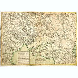
La Pologne Dressée sur ce qu'en ot donné Starovolsk, Beauplan, Hartnoch. . .
Large map of Poland, Lithuania, Belarus and part of Ukraine. The map is filled with detail and decorated with a title cartouche flanked by mythological figures.According ...
Date: Paris, 1773 - 1780
![[Crimea]. Carte de la Cromée.](/uploads/cache/25719-250x250.jpg)
[Crimea]. Carte de la Cromée.
Mapmaker, Captain Jan Hendrik van Kinsbergen (1735-1819). Published by H. Friesman in 1787. This map first appeared in 1776 and was the first Russian map of the newly ann...
Date: Amsterdam, H. Frieseman, 1787
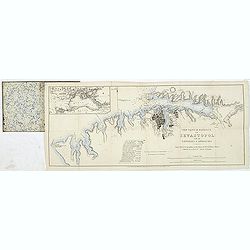
The town & harbour of Sevastopol with the batteries & approaches. . .
Rare colored linen backed map showing the harbour and town of Sevastopol, with soundings. In upper left corner a inset map (65x150mm) of the Black Sea. In bottom part a l...
Date: London, March 27th, 1854
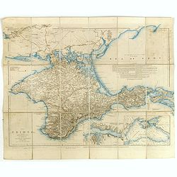
The Crimea, chiefly from surveys made by order of the Russian government. . .
Map of Crimea and the Sea of Azov. In lower right corner two inset maps showing Sebastopol inlet and harbour and a second one with the Black Sea. This second maps shows t...
Date: London, 1854
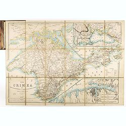
The Crimea by James Wyld Geographer to the Queen & H.R.H. Prince Albert.
Fourth edition of this folding map of the Crimea. In upper right corner an inset map of the areas around the Black Sea; "The Town & Harbor of Sevastopol with the...
Date: London, 1855
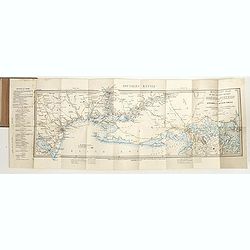
Military map of the countries between Odessa & Perekop with the stations of the Russian forces.
Rare colored linen-backed map showing Russian troop positions and Odessa Batteries. On the inside of the cover a list of "Wyld's list of recent publications : seat o...
Date: London, ca. 1855
![[Lot of 9 maps] Plan général de Sébastopol avec indication des travaux du siege et de la defense au 28 mars - 9 avril 1855. Feuille 10. xiii](/uploads/cache/33907-250x250.jpg)
[Lot of 9 maps] Plan général de Sébastopol avec indication des travaux du siege et de la defense au 28 mars - 9 avril 1855. Feuille 10. xiii
A group of nine (of 14) very rare panoramic town-plans of the siege of Sebastopol or maps of the Crimea. In lower margin : "Gravé au Dépôt topographique de la Gue...
Date: St. Petersburg, N. Thieblin, 1863
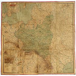
Mapa Polski i Krajów Osciennych - Wydanie trzecie. Opracowal Stanislaw Max. Wydani M. Arcta.
‘The Birth of Modern Poland on a map’ - an excellent wall map of Poland and surrounding regions, published in Warsaw near the end of World War I, when Poland’s fate...
Date: Warsaw, [H. Sklodowski], 1918
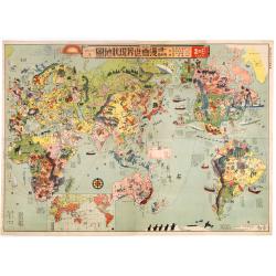
Japanese Stereotype Map of the World from 1932 Share Hitome de wakaru Manga sekai genjō chizu. At a glance: Cartoon Map of the Current World Situation. 目でわかる 漫画世界現状地圖
An extraordinary satirical map of the world was seen through Japanese eyes in the early 1930s as Japanese imperial ambitions strengthened. The map was published as an edi...
Date: Tokyo, Showa 7, or 1932
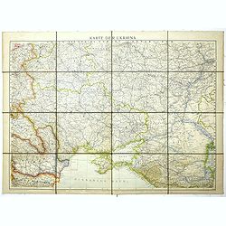
Karte der Ukraina.
A large political, economical and transportation map of Ukraine, printed three months after the beginning of the WW II in Ukraine. Shows the newest borders, streets and r...
Date: Vienna: Freytag u. Bernd u. Artaria August 1941
