Browse Listings in Europe > Russia / Baltic / Black Sea region
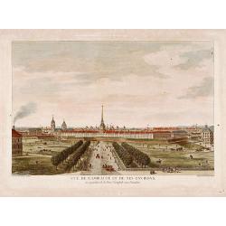
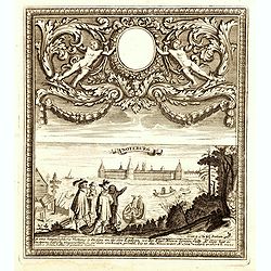
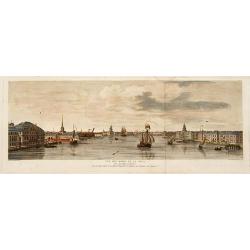
Vue de l'Amirauté et de ses environs.
Fine view of the admiralty buildings in St.Petersburg. Drawn and engraved under the direction of the imperial Academy of sciences and arts of Russia. After a design by De...
Date: Saint-Petersburg 1753
Selling price: ????
Please login to see price!
Sold
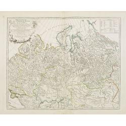
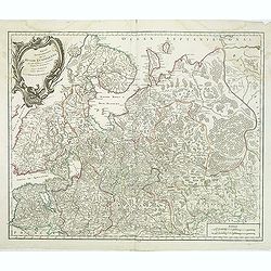
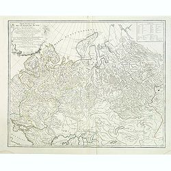
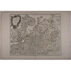
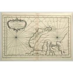
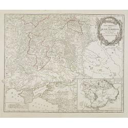
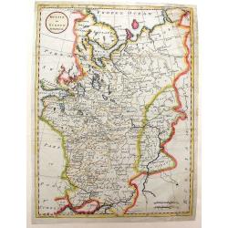
Partie Occidentale de l'Empire de Russie ou se trouve distinguée la Russie Européenne. . .
Detailed map of the European part of Russia.
Date: Paris, 1753
Selling price: ????
Please login to see price!
Sold in 2008
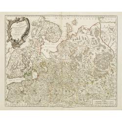
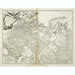
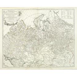
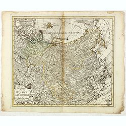
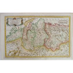
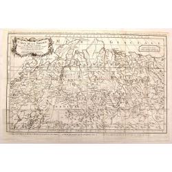
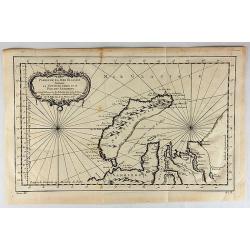
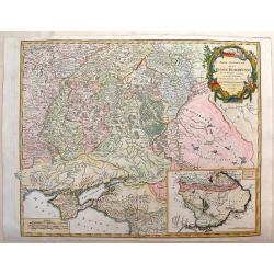
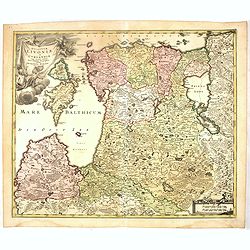
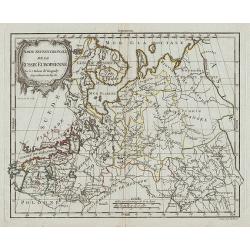
Partie Septentrionale de la Russie Européenne . . .
Detailed map of European part of Russia, including Finland, Lapland.
Date: Paris, 1753
Selling price: ????
Please login to see price!
Sold in 2008
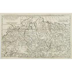
Karte von Sibirien. . . N°4.
Map of Siberia. In: Allgemeine Historie der Reisen zur Wasser und zu Lande: oder Sammlung aller Reisebeschreibungen.. in Englischen zusammen getragen, und aus demselben u...
Date: Leipzig, 1753
Selling price: ????
Please login to see price!
Sold in 2009
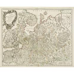
Partie Septentrionale de la Russie Européenne . . .
Map of the northern part of the Russian Empire, north of Moscow, including most of Finland.
Date: Paris, 1753
Selling price: ????
Please login to see price!
Sold in 2009
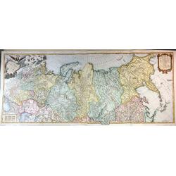
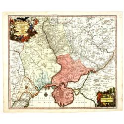
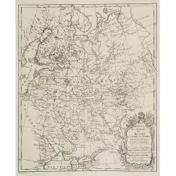
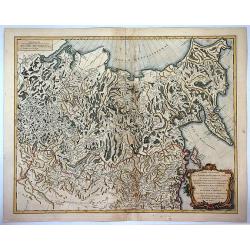
Carte Generale de L'Empire des Russes en Europe et en Asie dressée d'après les cartes de l'Atlas Russien. . .
Detailed map of Russia. extending from Poland and the Black Sea to Nova Zembla and the Jenisseniskoi region. Large decorative cartouche with six wind heads.
Date: Paris, 1753
Selling price: ????
Please login to see price!
Sold in 2011
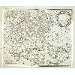
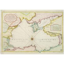
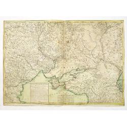
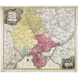
Partie méridionale de la Russie Européenne. . .
Detailed map of Ukraine and the Crimea. In lower right corner inset map of Cosaques. From his "Atlas Universel".Gilles Robert de Vaugondy (1688–1766), also kn...
Date: Paris, 1753
Selling price: ????
Please login to see price!
Sold in 2011
Partie Septentrionale de la Russie Européenne . . .
Detailed map of European part of Russia, including Finland, Lapland from his "Atlas Universel".Address and date in cartouche have been removed. Gilles Robert de...
Date: Paris, ca. 1753
Selling price: ????
Please login to see price!
Sold in 2011
Partie Occidentale de l'Empire de Russie ou se trouve distinguée la Russie Européenne. . .
Detailed map of the European part of Russia from his "Atlas Universel".Gilles Robert de Vaugondy (1688–1766), also known as Le Sieur or Monsieur Robert, and h...
Date: Paris, 1753
Selling price: ????
Please login to see price!
Sold in 2011
Partie Occidentale de l'Empire de Russie ou se trouve distinguée la Russie Européenne. . .
Detailed map of the European part of Russia, prepared after Russian maps. The map has a rather long title, the first part reading "Partie occidentale de l'empire de ...
Date: Paris, 1753
Selling price: ????
Please login to see price!
Sold in 2016
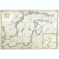
Carte de la Mer Baltique contenant les bancs, isles et costes comprises entre l'isle de Zelande et l'extrémité du Golfe de Finlande.
Important chart of the Baltic Sea with the coasts of Sweden, Finland, Russia, Estonia, Lettland, Lithuania and Poland. With many place names along the coasts, anchor plac...
Date: Versailles, 1753
Selling price: ????
Please login to see price!
Sold in 2014
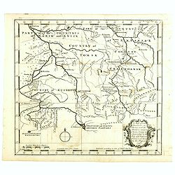
A map of some Provinces in Siberia, and the Borders toward China. . .
Detailed map of Siberia engraved by John Gibson for "The Gentleman's Magazine", founded by visionary Edward Cave, was the world's first monthly general interest...
Date: London, 1753
Selling price: ????
Please login to see price!
Sold in 2014
Carte Generale de L'empire des Russes en Europe et en Asie, Dressee D'apres les Cartes de L'Atlas Russien, Par le S. Robert de Vaugondy ....
An extensive map of the Russian Empire by Vaugondy, dated 1753. It stretches across the full extent of Russia from Finland to Kamchatka.There is a stunning title cartouch...
Date: Paris, 1753
Selling price: ????
Please login to see price!
Sold in 2015
Tab: Georg : Imperu Russici...
A fine original antique map of Russia, China, Japan and Korea, with a decorative title cartouche, and a Prussian duty stamp at lower right as usually for the Euler maps.T...
Date: Berlin, 1753
Selling price: ????
Please login to see price!
Sold in 2016
Partie Septentrionale De La Russie Europeenne... Par Le Sr Robert De Vaugondy Géog Ordin du Roi Avec privilege 1753.
Very detailed and large map of North West part of Russia, from the Gulf of Finland and Poland to the western part of Russia. Map dated.
Date: 1753
Selling price: ????
Please login to see price!
Sold in 2017
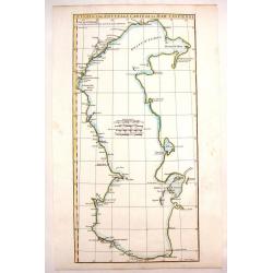
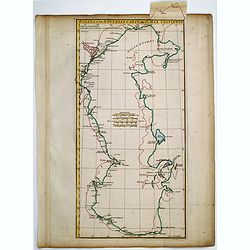
Essai D'Une Nouvelle Carte de la Mer Caspienne.
Simplistic map of the Caspian Sea.
Date: Paris, 1754
Selling price: ????
Please login to see price!
Sold in 2020
Essai D'Une Nouvelle Carte de la Mer Caspienne.
Interesting map of the Caspian Sea between Russia and Iran. Jean Baptiste d'Anville (1697-1782) born in Paris was perhaps the most important and prolific cartographer of ...
Date: Paris, 1754
Selling price: ????
Please login to see price!
Sold in 2013
An accurate map of Moscovy or Russia in Europe drawn from the best Authorities - by Emanuel Bowen
An attractive and highly detailed small map of Russia by Emanuel Bowen.
Date: London, 1754
Selling price: ????
Please login to see price!
Sold in 2012
Suite de la Carte de la Siberie et le Pays de Kamtschatka pour l'Histoire Generale des Voyages.
A striking map of eastern Siberia above and below the Arctic Circle, showing the Sea of Okhotsk, the Kamtschatka Peninsula, and Sakhalin Island. The map is from Bellin�...
Date: Paris, 1754
Selling price: ????
Please login to see price!
Sold in 2016
Essai d'une Nouvelle Carte de la Mer Caspienne.
Useful map of the Caspian Sea by the French cartographer d'Anville.
Date: Paris, ca. 1754
Selling price: ????
Please login to see price!
Sold in 2016
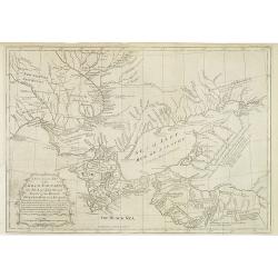
Carte De La Siberie Et des Pays voisins pour servir a l'Histoire general des Voyages . . .
Large detailed copper engraved map centering on Siberia, from Nouvelle Zemle and the Arctic Circle, down to Mer Caspiene (Caspian Sea) and Mer d'Aral. The map with captio...
Date: Paris, 1754
Selling price: ????
Please login to see price!
Sold in 2019
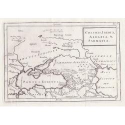
Colchis, Iberia, Albania & Sarmatia.
Outline map shows the Black Sea, Ukraine, Turkey, parts of Russia and adjacent areas, Christoph Cellarius, 17955 for "Geographia Antiqua".
Date: Leipzig, 1755
Selling price: ????
Please login to see price!
Sold in 2012
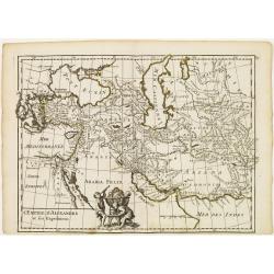
L'Empire d'Alexandre et ses Expeditions.
Fine map showing the territory conquered by Alexander the Great. With decorative cartouche on lower part, left to center fold. George Louis Le Rouge was active from 1740-...
Date: Paris, 1756
Selling price: ????
Please login to see price!
Sold in 2015
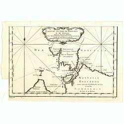
Carte des Isles Kouriles D'apres la Carte Russe.
A striking map of the Kuril Islands off the shore of Japan. The ownership of these volcanic islands has been in contention between Russia and Japan. The southern part of ...
Date: Paris, 1756
Selling price: ????
Please login to see price!
Sold in 2019
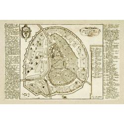
Moscow.
Very rare bird\'s-eye plan of Moscow. To the sides a historical description and a numbered key.George Christophe Kilian (1709-1780) active as engraver of Augsburg publish...
Date: Augsburg 1757
Selling price: ????
Please login to see price!
Sold
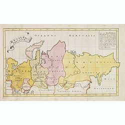
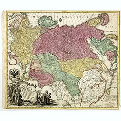
Spatiosissimum Imperium Russiae Magnae juxta recentissimas Observationes Mappa Geographica . . .
Decorative map of Russia, from Livonia to Kamchatka, China, Tibet, and part of Japan Filled with place names, a nomadic tent encampments in Mongolia.Kamchatka in a curi...
Date: Augsburg, 1757
Selling price: ????
Please login to see price!
Sold in 2013
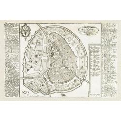
Moscow.
Very rare bird's-eye plan of Moscow. To the sides a historical description and a numbered key.George Christophe Kilian (1709-1780) active as engraver of Augsburg publishe...
Date: Augsburg 1757
Selling price: ????
Please login to see price!
Sold in 2009
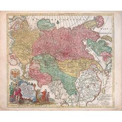
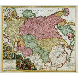
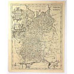
Russiae Imperium.
Scarce map of greater Russia, extending from Livonia in the west to Kamchatka. To the south it runs from Georgia (not shown as part of Russia) across the Caspian and Uzbe...
Date: Augsburg, 1757
Selling price: ????
Please login to see price!
Sold in 2013
Theatrum belli Russorum Victoriis illustratum sive Nova et accurata Turcicarum et Tartaricum. . .
Uncommon and decorative map of Ukraine, showing the theatre of the Russo-Turkish War in the Ukraine in 1735-1739. The map gives detailed information of the fortifications...
Date: Nuremberg, ca. 1757
Selling price: ????
Please login to see price!
Sold in 2013
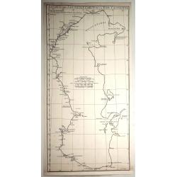
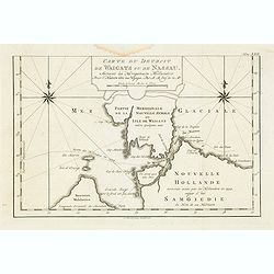
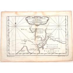
Carte Du Detroit de Waeigats ou De Nassau...
Detailed regional map of the Strait of Waeigats in the Arctic Sea. Includes a decorative title cartouche. One of the maps produced by Nichlas Bellin for Prevost d'Exiles ...
Date: Paris, 1757
Selling price: ????
Please login to see price!
Sold in 2020
Spatiosissimum Imperium Russiae Magnae juxta recentissimas Observationes Mappa Geographica . . .
Decorative map of greater Russia, extending from Livonia in the west to Kamchatka, China, Tibet, Taiwan, Korea and part of Japan in the east. To the south it runs from Ge...
Date: Augsburg, 1757
Selling price: ????
Please login to see price!
Sold in 2014
Eine Karte Von Dem Orenburger.
Fine detailed engraved map of the Orenburg region of Russia. It has a lovely Baroque cartouche. It was by Jonas Hanway in 1754.Orenburg is the administrative center of Or...
Date: Frankfurt, 1757
Selling price: ????
Please login to see price!
Sold in 2019
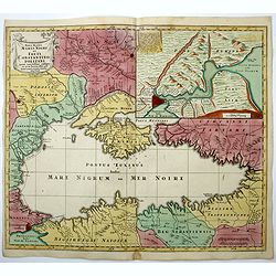
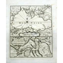
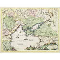
Carte réduite de la Mer Noire, dressée pour le service des vaisseaux du Roy. Par ordre de M. de Boynes, secretaire d'Etat..
Large scale chart of the Black Sea, with hand-coloringBellin (1703-1772) began working for the newly established Dépôt des Cartes et Plans de la Mari...
Date: Paris 1758
Selling price: ????
Please login to see price!
Sold
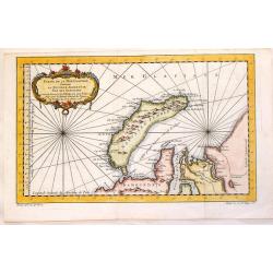
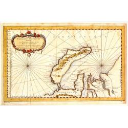
Partie de la Mer Glaciale Contenant La Nouvelle Zemble.
Detailed copper engraved map of Russia's Nova Zembla and a portion of the Northwest Passage. Produced by Bellin for "L'Histoire Generale des Voyages". Large bal...
Date: Paris, 1758
Selling price: ????
Please login to see price!
Sold in 2015
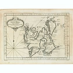
Carte Du Spits-Berg Suivant les Hollandois . . . 1758
A decorative map of Spitsbergen (Svalbard) with the adjacent islands of Franz Josef Land and Jan Mayan. The geographical features are typical with somewhat exaggerated ba...
Date: Paris, 1758
Selling price: ????
Please login to see price!
Sold in 2021
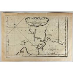
Carte du Detroit de Waigats ou de Nassau.
Showing the Dutch voyage of 1594 which proved Nova Zemlya was an island separated from the continent by the "le Waigats Detroit". Several sounding shown and one...
Date: Paris, 1758
Selling price: ????
Please login to see price!
Sold in 2020
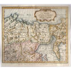
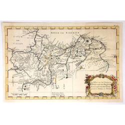
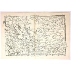
Carte de la Siberie et des Pays Voisins.
An interesting detailed map of North-Western Siberia, extending from the White Sea and the Caspian Sea in the west to Irkuckoi Province.Prepared by Jacques Nicolas Bellin...
Date: Paris, 1758
Selling price: ????
Please login to see price!
Sold in 2015
Carte du Detroit de Waegats ou de Nassau.
Interesting map of Northern Russia featuring the south (warm) side of the island, Nouvelle Zemble, one of the coldest places on earth. By Nicholas Bellin in France in 175...
Date: Paris, 1758
Selling price: ????
Please login to see price!
Sold in 2015
Partie de la Mer Glaciale Contenant la Nouvelle Zemle.
Detailed map of Nova Zembla and part of the Northeast passage in Northwest Russia. Published in "L'HISTOIRE GENERALE DES VOYAGES" by Nicholas Bellin.
Date: Paris, 1758
Selling price: ????
Please login to see price!
Sold in 2017
Carte du Detroit de Waeigats ou de Nassau.
Detailed regional map of the Strait of Waeigats in the Arctic Sea. Includes a decorative title cartouche. One of the maps produced by Bellin for Prevost d'Exiles' influen...
Date: Paris, 1758
Selling price: ????
Please login to see price!
Sold in 2017
Partie de la Mer Glaciale Contenant la Nouvelle Zemble et le Pais des Samoiedes.
An attractive copper engraved map of Nova Zembla, a frigid island north of Russia. It has a decorative rococo title cartouche. Jacques Nicolas Bellin (1703–1772) was a ...
Date: Paris, 1758
Selling price: ????
Please login to see price!
Sold in 2018
Partie de la Mer Glaciale, Contenant La Nouvelle Zemble et le Pais des Samoiedes.
A detailed map of Nova Zembla and part of the Northeast Passage at the top of Russia. From Prevost’s L’Histoire General des Voyages. It features a rococo cartouche.Ja...
Date: Paris, 1758
Selling price: ????
Please login to see price!
Sold in 2019
Partie de l'Empire de Russie comprise en Asie par le Sr. D'Anville. . .
Map of Russia.
Date: Paris, ca. 1759
Selling price: ????
Please login to see price!
Sold in 2009
Imperium Russiae Magnae..
With decorative title cartouche in lower left corner. Including the Asian part of Russia, China, Taiwan and part of Japan.
Date: Augsburg 1760
Selling price: ????
Please login to see price!
Sold
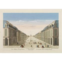
14e. Vüe d'Optique Representant La Grande Place de Petersbourg.
So-called optical print illustrating a perspective view of the portico of a Palace in Saint Petersburg. Published by Daumont, a well-known publisher of optical prints, es...
Date: Paris, 1760
Selling price: ????
Please login to see price!
Sold in 2017
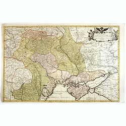
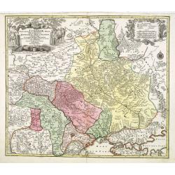
Partie Méridionale de la Russie Européenne. . .
Detailed map of Ukraine and Crimea. In the lower right corner inset map of Cosaques. A later edition, in which part of the address in the title cartouche was removed, and...
Date: Paris, ca 1760
Selling price: ????
Please login to see price!
Sold in 2008

Troisieme partie de la carte d'Europe, contenant le midi de la Russie, la Pologne, et la Hongrie, la Turquie y compris celle d'Asie presqu'entiere. . .
Wall map sized map of Russia, Crimea, Turkey, Cyprus and Holey Land. Centered on the Black Sea. Prepared by Jean Baptiste Bourguignon d'Anville (1697-1782). Ornamental ca...
Date: Paris, 1760
Selling price: ????
Please login to see price!
Sold in 2011
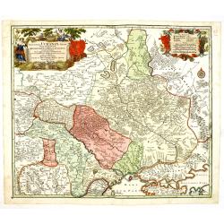
Partie Meridonale de la Russie Europeeennee
Important map of the southern part of Russia and the Ukraine. It has an inset of "Development de la Nouvelle Servie". Decorated with Rococo-style title cartouch...
Date: Paris, ca 1760
Selling price: ????
Please login to see price!
Sold in 2014
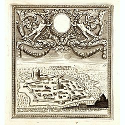
(Paide) Wittenstein in Lieffland / Wittenstein in Lieffland Oder Weissenstein kleine Stadt nebst eine Starken Schloss in der Lieflandische Provinz Estland. . .
Rare bird's eye view of Paide in Estonia by George Christian Kilian. The upper part of the engraving has very nice baroque decoration with an empty shield.Georg Christian...
Date: Augsburg, 1760
Selling price: ????
Please login to see price!
Sold in 2014
Noteburg. (Schüsselburg) / Ist eine hauptsächliche Festung an dem See Ladoga, wo der Fluss Nieva hinein fallt. . .
Rare bird's eye view of Schlüsselburg, east of St. Petersburg by George Christian Kilian. The upper part of the engraving has very nice baroque decoration with an empty ...
Date: Augsburg, 1760
Selling price: ????
Please login to see price!
Sold in 2014
Dvcatvvm Livoniae et Cvrlandiae cum vicinis. . .
A very attractive of Livonia, Estonia, Curlandia and the Baltic coast.
Date: Nuremberg, 1760
Selling price: ????
Please login to see price!
Sold in 2016
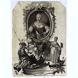
Elisabeth I. Russorum Imperatrixnata 1709 d. 20 Dec.
Portrait of Elizaveta Petrovna, Empress of Russia three-quarters length, body turned slightly to left but looking at the viewer, set in a decorative border.In lower part ...
Date: Augsburg, Paris, ca. 1760
Selling price: ????
Please login to see price!
Sold in 2016
Nova Mappa Maris Nigri et Freti Constantino Politani. . .
Decorative and uncommon map the Black Sea region.
Date: Augsburg, ca. 1760
Selling price: ????
Please login to see price!
Sold in 2018
Partie orientale de L'Empire de Russie en Asie ...
A detailed map of eastern Russia that was published in the "Atlas Universel". The map extends from Kamchatka to Obskaya Guba and included Lake Baikal. Detail ex...
Date: Paris , 1760
Selling price: ????
Please login to see price!
Sold in 2017
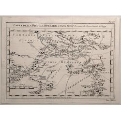
Carta Della Piccola Bukkaria e Paesi Vicini per Servire alla Storia Generale de Viaggi.
Interesting map of the Russian / Chinese border including Mongolia and the Gobi Desert. Jacques Nicolas Bellin (1703-1772) was one of the most important and proficient...
Date: Paris, 1760
Selling price: ????
Please login to see price!
Sold in 2020
Vue des bords de la Neva..
Sight of the edges of the river Neva between the Winter palace and the imperial Academy of sciences at Saint-Petersburg.
Date: Saint-Petersbourg 1761
Selling price: ????
Please login to see price!
Sold
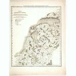
Partie Septentrionale de la Russie Européenne.
Map of the northern part of western Russia. From Gilles Robert de Vaugondy's Nouvel Atlas Portatif.
Date: Paris, 1762
Selling price: ????
Please login to see price!
Sold in 2011
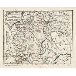
Partie Meridionale de la Russie Européenne, Tartarie Rusienne, Petite Tartarie.
Map of the southern part of western Russia. From Gilles Robert de Vaugondy's Nouvel Atlas Portatif.
Date: Paris, 1762
Selling price: ????
Please login to see price!
Sold in 2011
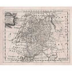
A New and Accurate Map of Russia in Europe
An antique copper engraved Map by Thomas Kichin, published in 1762 in London from "A New System of Geography..." by Anton Friedrich Busching. Decorated with a r...
Date: London, 1762
Selling price: ????
Please login to see price!
Sold in 2016
Carte de la Perse, de la Georgie, et de la Tartarie Independante.
Detailed map centered on "Tartarie Independante" the region east of the Caspian Sea with Kazachstan, Oezbekistan and Turkmenistan and also showing Georgia and I...
Date: Paris , 1762
Selling price: ????
Please login to see price!
Sold in 2017
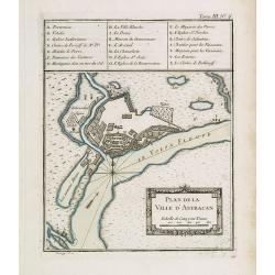
Plan de la ville d'Astracan.
Early town-plan of Astrakhan on the Volga River at the northern end of the Caspian Sea.Depths shown by soundings.From Bellin's Petit atlas maritime.Tome III N.6.Jacques N...
Date: Paris, 1764
Selling price: ????
Please login to see price!
Sold in 2012

Dédiée à Monsieur Boucher Premier Peintre du Roy, Recteur et Directur de son Academie Royalle de Peinture et de Sculpture...
Title page etching by Jean-Baptiste Le Prince (1734-1781), for "2me Suite de divers cris de marchands de Russie", showing typical Russian costumes. The sketches...
Date: Paris, 1764
Selling price: ????
Please login to see price!
Sold in 2013
![[MANUSCRIPT] Carte nouvelle de la Crimée et des pays circonvoisins.](/uploads/cache/30484-250x250.jpg)
[MANUSCRIPT] Carte nouvelle de la Crimée et des pays circonvoisins.
A beautiful manuscript map on paper. Showing the northern part of the Black Sea region with Crimea.Interesting are the border lines of "New Serbia", shown in th...
Date: ca. 1752-1764
Selling price: ????
Please login to see price!
Sold in 2024
Carte de la Mer Noire & Carte du Canal de la Mer Noire.
Two maps, one sheet. On top is a detailed map of the Black Sea and Crimea, showing major cities and rivers. Below with a map of the Bosporus showing Constantinople (Istan...
Date: Paris, 1764
Selling price: ????
Please login to see price!
Sold in 2016
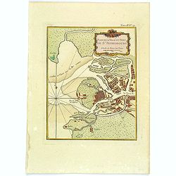
Plan de la Ville et Port de St. Petersbourg.
A nice and attractive map of St Petersburg by Bellin published in "Le Petit Atlas Maritime" and shows the city in detail along with the surrounding waterways. T...
Date: Paris, 1764
Selling price: ????
Please login to see price!
Sold in 2020
![KLAIPEDA, Lithuania: [Regni Borussiae Episcopatus Warmiensis Palatinatus Mariaeburgensis] et Culmensis cum Territorio Dantiscano et Ichnographia Urbis. . .](/uploads/cache/37064-250x250.jpg)
KLAIPEDA, Lithuania: [Regni Borussiae Episcopatus Warmiensis Palatinatus Mariaeburgensis] et Culmensis cum Territorio Dantiscano et Ichnographia Urbis. . .
Second plate of a rare wall map, shows the territory around Klaipeda (Memel) in Lithuania. Between 1701–1871 the area belonged to the Kingdom of Prussia. This wall map ...
Date: Berlin, Preussische Akademie der Wissenschaften 1763-1766
Selling price: ????
Please login to see price!
Sold in 2016
Suite de la route de Paris a Tobolks par Rotnica, Riga et Kipina.
Rare map showing Lithuania, Latvia, Estonia and part of Poland. The map has original out line color and the route taken by Jean Chappe d'Auteroche crossing this area is d...
Date: Paris, 1768
Selling price: ????
Please login to see price!
Sold in 2017
A New & Accurate Map of the Krim Tartary, the Sea of Azof, and Parts of the Rivers Dneper, Bog and Kuban.
Interesting, engraved map of the northern Black Sea and southern Ukraine regions, during the period of hostilities between the Turks and Russians, 1768-74. Published in t...
Date: London, 1769
Selling price: ????
Please login to see price!
Sold in 2013
Nouveau théâtre de la guerre entre les Russes les turcs et les polonois confédérés.
Very rare separately published map of Crime region. With a large title cartouche lower left "Nouveau theâtre de la guerre entre les russes, les turcs et les polonoi...
Date: Paris, 1769
Selling price: ????
Please login to see price!
Sold in 2010
![[SET OF 5 MAPS OF THE CASPIAN SEA, RUSSIA, ca. 1769]](/uploads/cache/91829-250x250.jpg)
[SET OF 5 MAPS OF THE CASPIAN SEA, RUSSIA, ca. 1769]
Interesting set of five copper-engraved maps of the Caspian Sea by or after D'Anville, dating to around 1769. List of the maps: 1: Premiere Révolution de la mer Caspie...
Date: Paris, c1769
Selling price: ????
Please login to see price!
Sold in 2011
Carte exacte d'une Partie de L'Empire de Russie et de la Pologne meridionale renfermant l'Ukraine . . .
Rare map of Eastern Europe published by Facius Brothers, published in Bonn, including Poland, Lithuania, Russia and Ukraine. This is the first edition of the map, which w...
Date: Bonn, 1769
Selling price: ????
Please login to see price!
Sold in 2022
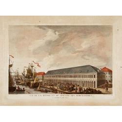
Vue de la bourse et du magazin des marchandises..
Fine view of the stock exchange and storehouses in St.Petersburg. Drawn and engraved under the direction of the imperial Academy of sciences and arts of Russia. After a d...
Date: Saint-Petersburg 1770
Selling price: ????
Please login to see price!
Sold
![[Untitled Russan provinces]](/uploads/cache/25959-250x250.jpg)
[Untitled Russan provinces]
Map of Russian provinces. Centered on Moscow. Engraved by Liebaux.
Date: Paris, ca 1770
Selling price: ????
Please login to see price!
Sold in 2010
Nuova Carta Geografica per servire alla storia della Guerra Presente tra la Russia, e la Porta Ottomana..
Decorative and rare map of the Black Sea Region and contiguous countries, centered on Crimea.With impressive title cartouche illustrating a siege of a stronghold. &cu...
Date: Venice, 1770
Selling price: ????
Please login to see price!
Sold in 2009
Russia in Europe by Thos. Bowen
Showing "Russia in Europe" by Thomas Bowen. It was engraved for and published by "Barlow's General History of Europe" in about 1770. The map covers th...
Date: London, c. 1770
Selling price: ????
Please login to see price!
Sold in 2015
Theatrum belli Russorum Victoriis illustratum sive Nova et accurata Turcicarum et Tartaricum. . .
This is the re-issue of Seutter's map with the Privilege in lower left part. Uncommon and decorative map of Ukraine, showing the theatre of the Russo-Turkish War in the U...
Date: Nuremberg, ca. 1770
Selling price: ????
Please login to see price!
Sold in 2016
Amplissima Ucraniae Regio, Palatinatus Kioviensem et Braclaviensem. . .
This is the re-issue of Seutter's map of Ukraine, with privilege underneath the title cartouche. With excellent detail of the topography, including rivers, hills, etc.Dec...
Date: Nuremberg, ca. 1770
Selling price: ????
Please login to see price!
Sold in 2013
Amplissima Ucraniae Regio, Palatinatus Kioviensem et Braclaviensem. . .
Seutter's map of Ukraine, with privilege underneath the title cartouche. With excellent detail of the topography, including rivers, hills, etc.Decorated with two attracti...
Date: Nuremberg, ca. 1770
Selling price: ????
Please login to see price!
Sold in 2014
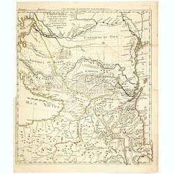
Frontieres de Turquie et de Russie Entre la Mer Caspienne et la Mer d'Asof renfermant le Kuban la Grande et Petitte Kabardie
Fine and rare map centered on present-day Georgia, Armenia and Azerbaijan. Depicting the progress of the Russo-Turkish war between 1768-1774. In bottom northern part of A...
Date: Paris, 1770
Selling price: ????
Please login to see price!
Sold in 2014
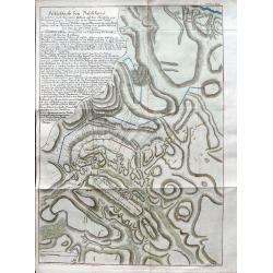
Feldschlacht bey Baschkiwizi in welcher Fürst Alexander Gallizin auf dem Marsche von Tschernowiz gegen Chozim von 70.000 Tartarn und Türken. . .
A very rare plan of the battle near Chotyn in the year 1769. The city was besieged by the Russian prince Alexander Galitzine. Khotyn is a city in Chernivtsi Oblast of wes...
Date: Vienna, ca 1770
Selling price: ????
Please login to see price!
Sold in 2019
