Browse Listings in Europe > Netherlands > Brabant

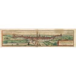
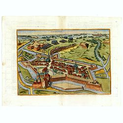
's-Hertogenbosch and Mechelen.
Very early panoramic views of 's-Hertogenbosch and Mechelen. Size of the sheet is 364x235mm.From his Geographia , that great compendium of Renaissance knowledge.
Date: Basle, 1544
Selling price: ????
Please login to see price!
Sold in 2010

's-Hertogenbosch and Mechelen
Very early panoramic view of 's-Hertogenbosch and Mechelen. Size of the sheet is 364x235mm. From his Geographia, that great compendium of Renaissance knowledge.
Date: Basle, ca. 1544
Selling price: ????
Please login to see price!
Sold in 2012

's-Hertogenbosch / Antwerp / Alva.
Very early panoramic view of 's-Hertogenbosch and Antwerp. Size of the sheet is 334x222mm. From his Geographia , that great compendium of Renaissance knowledge. An exciti...
Date: Basle 1544
Selling price: ????
Please login to see price!
Sold
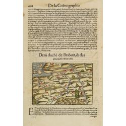
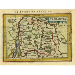
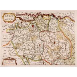
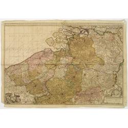
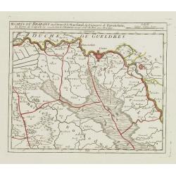
DE la duché de Brabant, & des principales villes d'icelle.
A woodcut map and one of the oldest maps of Brabant, covering the area from Antwerp in the west to Muenster in the east, from Utrecht in the north to Namur in the south.T...
Date: Basle 1552
Selling price: ????
Please login to see price!
Sold
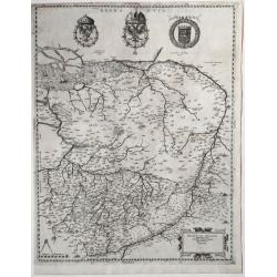
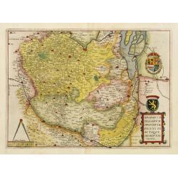
Brabantia Belgarum Provinciae recens exactaque descriptio Venetiis.
A very early Brabant map, published in Venice, 1567.In excellent condition, and uncolored. On centre top, the crowned coat of arms of the Emperor Charles V with the emble...
Date: Venice, 1567
Selling price: ????
Please login to see price!
Sold in 2020

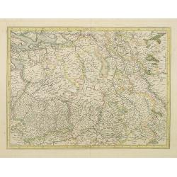
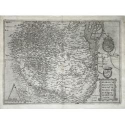
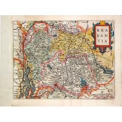
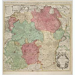
Brabantiae Germaniae Inferioris.
Based on a map by Jacob van Deventer, by order of King Charles V. Jacob van Deventer was one of the first cartographers of the Southern Netherlands. He was famous for his...
Date: Antwerp, 1574
Selling price: ????
Please login to see price!
Sold in 2011
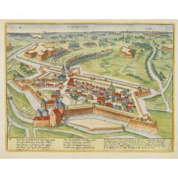
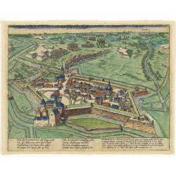
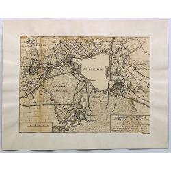
Tshertogenbosch - Buscumducis oppidum ludo Literario. (s-Hertogenbosch)
Very desirable and early of s-Hertogenbosch. "s-Hertogenbosch was granted a municipal charter in 1185 and in the late Middle Ages it was a market center for farmers...
Date: Cologne, (1572) 1577
Selling price: ????
Please login to see price!
Sold in 2020
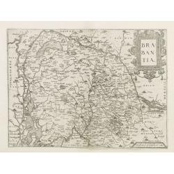
Brabantia.
Map of Brabant from Guicciardini's "Description de touts les Pais-Bais" edited by Plantin in 1582. The map drawn after Ortelius'map of Brabant, and after the...
Date: Antwerp, 1582
Selling price: ????
Please login to see price!
Sold
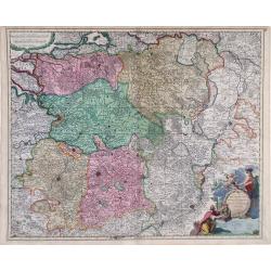
Brabantia, Gulick et Cleve.
The full coloring of the different areas with the borderlines in the same color, only slightly darker, is typical of the 16th century.
Date: Duisburg, 1585
Selling price: ????
Please login to see price!
Sold in 2017
EYNDHOVEN - Nach dem Eindhoven mitt kriegs macht. . . .
Earliest printed bird's-eye view of Eindhoven. Showing the siege of April 13-23 1583. On April 22nd the young Count Carel van Mansfeld was taking the town after a 9 days ...
Date: Cologne, 1590
Selling price: ????
Please login to see price!
Sold in 2009
EYNDHOVEN - Nach dem Eindhoven mitt kriegs macht. . . .
Earliest printed bird's-eye view of Eindhoven. Showing the siege of April 13-23 1583. On April 22nd the young Count Carel van Mansfeld was taking the town after a 9 days ...
Date: Cologne, 1590
Selling price: ????
Please login to see price!
Sold in 2015
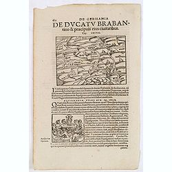
![De Ducatu Brabantino .. [Brabant]](/uploads/cache/13794-250x250.jpg)
De Ducatu Brabantino .. [Brabant]
On recto an early map of Brabant (Map : 94x135 mm). From a Latin text edition of his "Geographia", that great compendium of Renaissance knowledge.
Date: Bâle, 1550-1590
Selling price: ????
Please login to see price!
Sold
De Germania de Ducatu Brabantino. . . (Brabant)
On recto a map of the province of Brabant covering present-day the Netherlands and Belgium. From a Latin text edition of his Geographia , that great compendium of Renaiss...
Date: Basle, 1550-1590
Selling price: ????
Please login to see price!
Sold in 2013
EYNDHOVEN - Nach dem Eindhoven mitt kriegs macht. . . .
Earliest printed bird's-eye view of Eindhoven. Showing the siege of April 13-23 1583. On April 22nd the young Count Carel van Mansfeld was taking the town after a 9 days ...
Date: Cologne, 1590
Selling price: ????
Please login to see price!
Sold in 2023
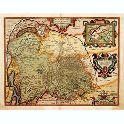
Brabantiae Belgarum Provinciae recens. . .
Based on a map by Jacob van Deventer, by order of King Charles V. Jacob van Deventer was one of the first cartographers of the Southern Netherlands. He was famous for his...
Date: Antwerp, 1593
Selling price: ????
Please login to see price!
Sold
Brabantiae Belgarum Provinciae Exactaque Descriptio.
A very rare Brabant map, Netherlands, Belgium, Brabant; by Gerard de Jode - Brabantiae Belgarum Provinciae recens exactaque descriptio - 1595.Orientation: is West upwards...
Date: Antwerp, 1595
Selling price: ????
Please login to see price!
Sold in 2021
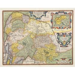
Brabantiae Descriptio.
In an inset Mechelen and surroundings. Decorative scale and title cartouche with dedicational initials which may refer to Laurentius Michaelis who may be connected with t...
Date: Antwerp 1598
Selling price: ????
Please login to see price!
Sold
Le Duche de Brabant (untitled)
Fine Mercator/Hondius map of the Brabant region of Northern Belgium. Shows the city of Brussels in the west. Accompanying French text is on verso. Fantastic, vibrant orig...
Date: Amsterdam, 1610
Selling price: ????
Please login to see price!
Sold in 2010
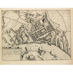
Situs Oppidi Graviae.
From Ludovico Guicciardini.'s description of the Netherlands ' Beschrijvinghe van alle de Nederlanden anderssins ghenoemt Neder-Duytslandt ', published by Willem Blaeu.A ...
Date: Amsterdam, W.Blaeu, 1612
Selling price: ????
Please login to see price!
Sold
Brabantiae Descriptio.
From Ludovico Guicciardini's description of the Netherlands "Beschrijvinghe van alle de Nederlanden anderssins ghenoemt Neder-Duytslandt", published by Willem B...
Date: Amsterdam, W.Blaeu, 1612
Selling price: ????
Please login to see price!
Sold in 2014
Brabantiae Descriptio.
Striking example of Ortelius' second map of Brabant, including his home town of Antwerp. From the very rare Spanish text edition.Rotterdam is shown in the west and Liege ...
Date: Antwerp, 1598-1612
Selling price: ????
Please login to see price!
Sold in 2009
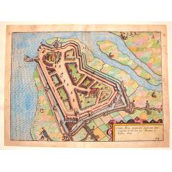
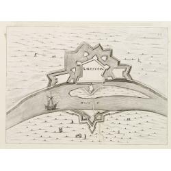
Ciutas Mons Geertrudan. (Geertruidenberg)
Fine hand-colored, copper engraving of the Fortification of Geertruidenberg, Netherlands. Very detailed with actual soldiers, animals, canons etc. pictured. Strong strapw...
Date: Amsterdam, 1613
Selling price: ????
Please login to see price!
Sold in 2016
Brabantia.
Map of the Province of Brabant, with the city Breda 's Hertogenbosch and also the Belgium part of Brabant.
Date: Amsterdam 1616
Selling price: ????
Please login to see price!
Sold
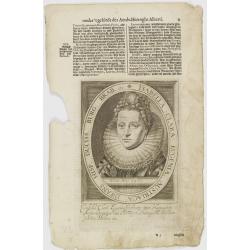
Isabella Clara Eugenia, Austriaca Infans Hisp. Duciss. Burg. Brab. etc.
The engraving depicts a half length oval portrait of \"Isabella Clara Eugenia\", signed lower right corner N. de Cleck\". Nicolaes de Clerck (de klerc) was...
Date: Amsterdam, Cloppenburch, 1621
Selling price: ????
Please login to see price!
Sold in 2008
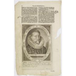
Albertus D. G. Archidux Austriae. Dux Burgund. Brab. Com. Fland. etc.
The engraving depicts a half length oval portrait of \"Albertus D. G. Archidux Austriae\", signed lower right corner N. de Cleck\". Nicolaes de Clerck (de ...
Date: Amsterdam, Cloppenburch, 1621
Selling price: ????
Please login to see price!
Sold in 2008
![[No title - Insert map " Caerte van Een Gedeelte van Brabant"]](/uploads/cache/47915-250x250.jpg)
[No title - Insert map " Caerte van Een Gedeelte van Brabant"]
Map of the siege of Bergen op Zoom by Spinola showing the location of the quarters and a larger part of the area around Reimerswaal, Tholen and Steenbergen, lower right i...
Date: Amsterdam, 1622
Selling price: ????
Please login to see price!
Sold in 2022

Nova Brabantiae Ducatus Tabula. . .
First and only edition with borders. This beautiful and very rare carte à figures map has been engraved by Dirk Gryp who engraved only three town views in the lower left...
Date: Amsterdam, 1622-1627
Selling price: ????
Please login to see price!
Sold in 2009
![No title. [Brabant]](/uploads/cache/12186-250x250.jpg)
No title. [Brabant]
Brabant, Gulick and Cleve.
Date: Amsterdam, 1630
Selling price: ????
Please login to see price!
Sold in 2015

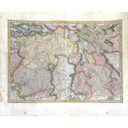
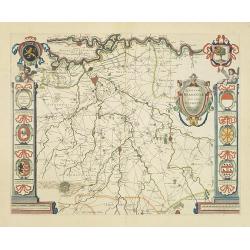
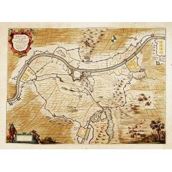
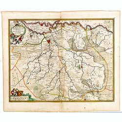
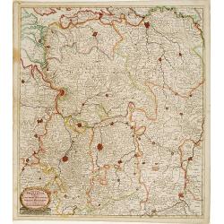
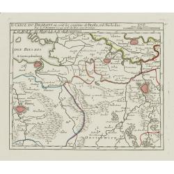
Pars Septentrionalis Brabantiae, et circumiacentium Provinciarum.
Rare map of the area between Mechelen and the Schelde in the West and the Maas and the river Aade in the East, reaching to Dordrecht in the North and to Eindhoven in the ...
Date: Amsterdam, after 1629 - 1634
Selling price: ????
Please login to see price!
Sold in 2014

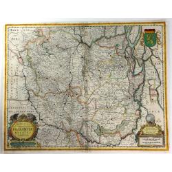
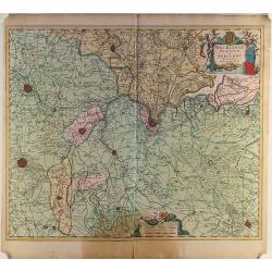
Quarta pars Brabantiae cujus caput Sylvaducis. . .
This is a rare first state of Blaeu's map of Brabant (north). This marvelous map is only found in the relatively scarce Novus Atlas by Willem Blaeu, published in Amsterd...
Date: Amsterdam, 1634
Selling price: ????
Please login to see price!
Sold in 2012

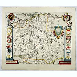
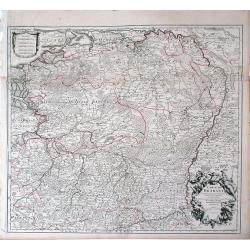
Novissima et Accuratissima Brabantiae Ducatus Tabula.
North is to the right. Like all other maps of Brabantiae Ducatus, it encloses the area between the rivers Rhine, Maas and Schelde, with Namur as the most southern town. O...
Date: Amsterdam, 1638
Selling price: ????
Please login to see price!
Sold in 2012

Tabula Bergarum ad Zoman Stenbergae.
A small section of the center has been rubbed: otherwise excellent. Rather rare to see an early road map in this time. It shows the city of Bergen op Zoom in Brabant.As W...
Date: Amsterdam, 1638
Selling price: ????
Please login to see price!
Sold in 2017
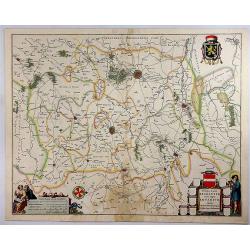
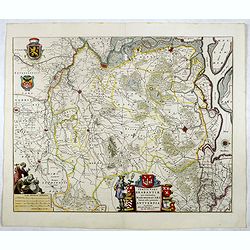
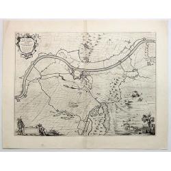
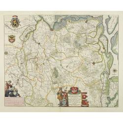
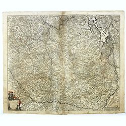
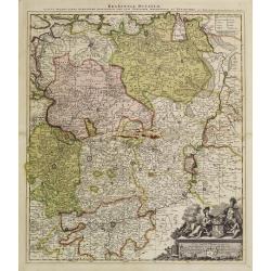
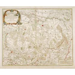
Prima Pars Brabantiae Cuius Caput Louanium.
A striking map showing the region of Loewen in the Duchy of Brabant in the Netherlands. Loewen and Tienen are shown prominently in the centre of the map. Inside the map a...
Date: Amsterdam, 1645
Selling price: ????
Please login to see price!
Sold in 2018
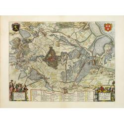
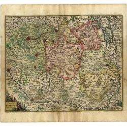
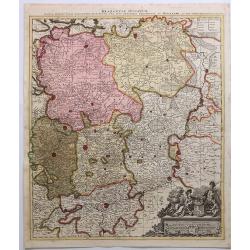
Quarta pars Brabantiae cujus caput Sylvaducis.
A good and dark impression in strong original colors.The third state. The coat of arms of Brabant and 's-Hertogenbosch appears on the map. The municipal arms in the colum...
Date: Amsterdam, 1645
Selling price: ????
Please login to see price!
Sold in 2008
Quarta pars Brabantiae cujus caput Sylvaducis.
A good and dark impression in strong original colors.The third state. The coat of arms of Brabant and 's-Hertogenbosch appears on the map. The municipal arms in the colum...
Date: Amsterdam, 1645
Selling price: ????
Please login to see price!
Sold
Novissima et Accuratissima Brabantiae Ducatus Tabula.
A fine map of The Netherlands that encloses the area between the rivers Rhine, Maas and Schelde, with Namur as the most southern town. North is shown to the right.On the ...
Date: Amsterdam, 1645
Selling price: ????
Please login to see price!
Sold in 2016
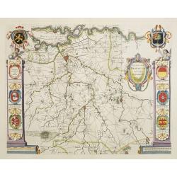
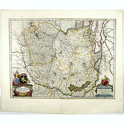
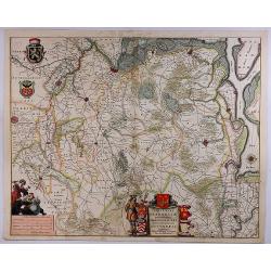
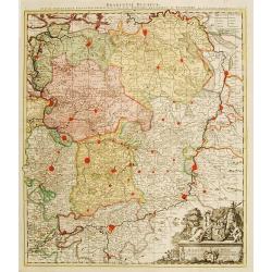
Tertia Pars Brabantiae.
West is at the top. At the lower left the cartouche embellished with male figures with compasses, globe, book and winckel-kruis . At bottom, right of the centre, a beauti...
Date: Amsterdam, 1645
Selling price: ????
Please login to see price!
Sold in 2019
Nieuwe Kaerte van Breda belegert door syne Altesa Frederick Hendrick van Nassou Prince van Orangien . . .
This very rare map appeared only in one atlas: Belgium sive Germania Inferior continens Provincias singulares Septemdecim. iuxta artem Geographicam perfectissime descript...
Date: Amsterdam, 1645
Selling price: ????
Please login to see price!
Sold in 2012
Brabantia Ducatus.
West is at the top. On the lower left a magnificent cartouche with a sitting female figure carrying a globe and compasses and the coat of arms of Brabant. The map enclose...
Date: Amsterdam, 1645
Selling price: ????
Please login to see price!
Sold in 2018
Quarta pars Brabantiae cujus caput Sylvaducis.
The coat of arms of Brabant and 's-Hertogenbosch appear on the map. As this is an early state of this map, the municipal arms in the columns on right and left-hand side h...
Date: Amsterdam, 1645
Selling price: ????
Please login to see price!
Sold in 2018
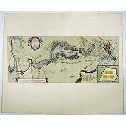
Tabula Bergarum ad Zoman Stenbergae.
This map shows the city of Bergen op Zoom in Brabant.
Date: Amsterdam, 1645
Selling price: ????
Please login to see price!
Sold in 2018
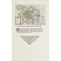
Willemstad.
Plan of the Brabant town "Willemstad" from Blaeus townbooks of the Netherlands. Latin text underneath desribing the foundation of the town by William of Orange...
Date: Amsterdam 1648
Selling price: ????
Please login to see price!
Sold
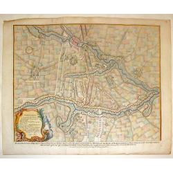
Gravia obsessa et expugnata armis ordinum Belgicae..
A military map showing Grave and the surrounding area with fortifications. With a decorative title cartouche, a blank cartouche with two figures and a military scene vign...
Date: Amsterdam 1649
Selling price: ????
Please login to see price!
Sold
Gravia Obsessa et Expugnata Armis Ordinum Belgicae Confoederate.
A military map showing Grave, Brabant,Netherlands and the surrounding area with fortifications. featuring a decorative title cartouche, a blank cartouche with two figures...
Date: Amsterdam, 1649
Selling price: ????
Please login to see price!
Sold in 2019
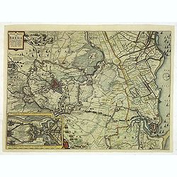
Breda Obsessa Et Expugnata a Celsissimo Friderico Henrico.
Fine map of Breda and environs to show the siege of the town by Frederik Hendrik, Prince of Orange, in 1637. Lower left a decorative cartouche with a dedication and coats...
Date: Amsterdam, 1649
Selling price: ????
Please login to see price!
Sold in 2013
Tertia Pars Brabantiae.
West is at the top. At the lower left the cartouche embellished with male figures with compasses, globe, book and winckel-kruis . At bottom, right of the centre, a beauti...
Date: Amsterdam, 1650
Selling price: ????
Please login to see price!
Sold in 2009
Tertia Pars Brabantiae. . .
A striking map showing part of present-day Belgium and Dutch Brabant. West is at the top. At the lower left the cartouche is embellished with male figures with compasses,...
Date: Amsterdam, 1650
Selling price: ????
Please login to see price!
Sold in 2018
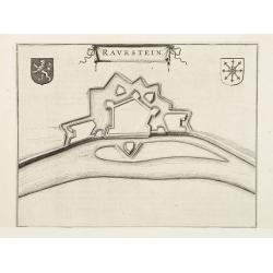
Ravenstein.
A bird's eye view engraving of the Dutch city of Ravenstein.Latin text on verso.
Date: Amsterdam 1650
Selling price: ????
Please login to see price!
Sold
Brabantiae.
Charming little map of Brabant made by Gabriel Bucelin (1599-1681). Bucelin was a Swiss genealogist and an author of several books and a number of manuscript maps of Germ...
Date: Ulm, Johannes Görlin, 1658-1664
Selling price: ????
Please login to see price!
Sold in 2008
Ravestein.
Plan of the Dutch town Ravestein in the nowadays province Brabant. From Priorato's book "Schauplatz dess Niderlands" printed and edited in Vienna 1673.
Date: Vienna 1673
Selling price: ????
Please login to see price!
Sold
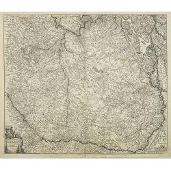
Tabula Ducatus Brabantiae continens Marchionatum Sacri Imperii et Dominium Mechliniense emendate à F. de Wit 1666
Shows present-day Belgium and Dutch province of Brabant. Including the Maas and Waal rivers. Shows Antwerp, Brussels, Namur, Liege and Venlo among other towns and cities....
Date: Amsterdam, 1680
Selling price: ????
Please login to see price!
Sold in 2012
Ducatus Brabantiae Continens Marchionatum Sacri Imperii..
Shows present-day Belgium and Dutch province of Brabant. Including the Maas and Waal rivers. Shows Antwerp, Brussels, Namur, Liege and Venlo among other towns and cities....
Date: Amsterdam 1680
Selling price: ????
Please login to see price!
Sold
Tabula Ducatus Brabantiae continens Marchionatum Sacri Imperii et Dominium Mechliniense emendate à F. de Wit 1666
Shows present-day Belgium and Dutch province of Brabant. Including the Maas and Waal rivers. Shows Antwerp, Brussels, Namur, Liege and Venlo among other towns and cities....
Date: Amsterdam, 1680
Selling price: ????
Please login to see price!
Sold in 2016
Mechelinia Dominium et Aerschot..
Detailed map of the southern part of The Netherlands and the northern part of Belgium with Antwerp and Brussels. Large (colored) cartouche with a coat of arms and putti.
Date: Amsterdam ca.1680
Selling price: ????
Please login to see price!
Sold in 2014
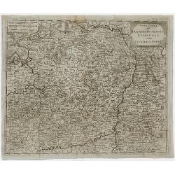
Quartae Partis Brabantiae seu Ditionis Silvae Ducis...
Very detailed map of the fourth quarter of Brabant, including the towns of Tilburg, Den Bosch, Helmond and Eindhoven. Based on Willibrordus van der Burght map of 1635.Rar...
Date: Amsterdam, 1688
Selling price: ????
Please login to see price!
Sold in 2015
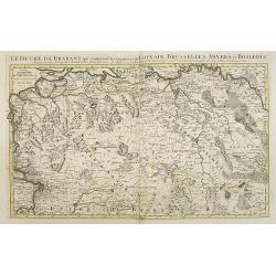
Le Duché de Brabant, qui comprend les Quartiers de LOUVAIN, BRUSSELLES, ANVERS, et BOSLEDUC . . .
Fine map of the present-day Dutch province of North Brabant. The map notes Nicolas Sanson as the mapmaker and claims that the map was published by Alexis-Hubert Jaillot (...
Date: Amsterdam, 1692
Selling price: ????
Please login to see price!
Sold in 2009
Ducatus Brabantiae
Small map of the Southern part of The Netherlands.
Date: Antwerp, 1692
Selling price: ????
Please login to see price!
Sold
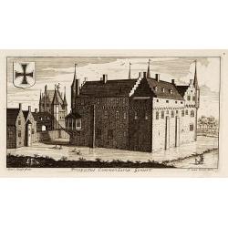
Prospectus Commandariae Gemert.
One of the earliest views of the Castle of Gemert.
Date: Amsterdam, 1695
Selling price: ????
Please login to see price!
Sold in 2017
Ducatus Brabantia divise in Hispanicam et Batavam?
Carol Allard map of Dutch and Belgium Brabant and Holland with beautiful original color. Shows from cities of Breda, Holland in the north to Namen, Belgium in the south.
Date: Amsterdam, 1696
Selling price: ????
Please login to see price!
Sold in 2010
Ducatus Brabantiae tabula continens sacri imperii. . .
Rare issue of Cornelis Danckert's attractive map of Brabant.Decorative title cartouche lower left hand corner.
Date: Amsterdam, 1700
Carte de Brabant.
Guillaume del'Isle map of Brabant region of Belgium and the Netherlands.
Date: Paris, 1705
Selling price: ????
Please login to see price!
Sold in 2010
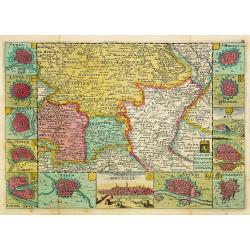
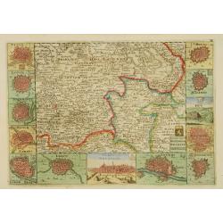
Kaart van 't Hertogdom Brabant.
From his atlas Oorlogs tablessen, Oft uytgesochte Kaarten. Covering the Dutch and Belgium province of Brabant and Limburg.Surrounded by 13 plans of the towns of 's-Hertog...
Date: Amsterdam 1706
Selling price: ????
Please login to see price!
Sold
La Mayerie de BOLDVC, autrement dict Bois le Duc.
From his atlas Oorlogs tablessen, Oft uytgesochte Kaarten. Covering the so-called area Meierij van 's-Hertogenbosch. Eindhoven in the centre of the map.
Date: Amsterdam 1706
Selling price: ????
Please login to see price!
Sold
Ducatus Brabantiae, complrctens dominia Lovanii, Bruxellarum, Antverpia. . . / Carte du Brabant. . .
Covens & Mortier's map of Brabant, based upon De L'Isle's map of 1700. The North is orientated to the top side of the map. On the lower right a cartouche decorated wi...
Date: Amsterdam, 1720
Selling price: ????
Please login to see price!
Sold in 2013
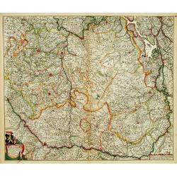
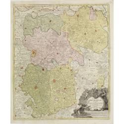
Brabantiae Ducatus.
On the lower right a cartouche embellished with figures, trees, birds, fruits and the heraldic arms of Brabant, held by a female figure. At bottom a dedication to Herman ...
Date: Amsterdam, 1720
Selling price: ????
Please login to see price!
Sold in 2011
Het groot en by naar geduurige schouwburg van den Europeeschen Oorlogh behelsende Brabant, Vlanderen, Henegouwe, Namur en Luyck, etc. te Amsterdam by P.Schenk.
Rare and interesting map of Brabant, and present-day Belgium. The wall map consists of two pages, pasted together and in top a separate printed slip with its title Het gr...
Date: Amsterdam 1720
Selling price: ????
Please login to see price!
Sold
Brabantiae Ducatus
On the lower right a cartouche embellished with figures, trees, birds, fruits and the heraldic arms of Brabant, held by a female figure. At bottom a dedication to Herman ...
Date: Amsterdam 1720
Selling price: ????
Please login to see price!
Sold
Brabantiae Ducatus.
A detailed map of the duchy of Brabant, now divided between the Netherlands and Belgium. Brussels and Antwerp are at left, Maestricht at right.On the lower right a cartou...
Date: Amsterdam, 1720
Selling price: ????
Please login to see price!
Sold in 2018
Kaart van't Hertogdom Brabant.
Attractive map centered on the province of Brabant, including the maps of Venlo, Leuven, Roermond, Namur, Liege, Leeuw, Breda, Mechelen, Maastricht, s'Hertogenbosch, Antw...
Date: Amsterdam 1735
Selling price: ????
Please login to see price!
Sold
BRABANT
The Homann-family became the most important editors of atlases in Germany during the 18th. century. This map of Brabant shows the quarters: Louvain, Brussels, Antwerp, s...
Date: Nurnberg ca.1740
Selling price: ????
Please login to see price!
Sold
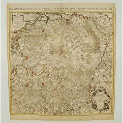
Nuova Carta del Ducato di Brabante Limburgo e della Gheldria Superre.
A fine map of the Duchy of Brabant and Limburg, Germany that appeared in "Novissimo Atlas published by Giovanni Albrizzi, a work based on the work of Isaak Tirion. I...
Date: Venice, 1740
Selling price: ????
Please login to see price!
Sold in 2020
Plan of the Lines of Brabant.
Fine copper engraved plan featuring the 1705 battle in Brabant between the Duke of Marborough and Field-Marshall d'Averquerque. Decorative rococco cartouche with the expl...
Date: London, 1742
Selling price: ????
Please login to see price!
Sold in 2016
Carte du Comté du Brabant, Dressée sur plusieurs Cartes particulières..
Map of the old Duchy of Brabant, which covers parts of the Netherlands and Belgium largely between the Meuse or Maas River and the North Sea. Highly detailed with depicti...
Date: Amsterdam c. 1745
Selling price: ????
Please login to see price!
Sold
Carte du Brabant ou.. le Maesland.. de Ravenstein..
Covering north-eastern part of present day Noord-Brabant including towns of Grave, Gennep, Vlierlingsbeek, Venray, Bakel, Boxmeer, Heeswijk Dinther.
Date: Paris 1748
Selling price: ????
Please login to see price!
Sold
I. Carte du Brabant où sont les environs de Berg-op-zoom, de Tolen dans la Zélande. et de Willemstat dans la Hollande.
Nice small map centered on the western part of North Brabant. It shows Bergen op Zoom, Tholen, Willemstad, Klundert, etc.From Atlas Portatif Universel, by Robert de Vaugo...
Date: Paris, later than 1748
Selling price: ????
Please login to see price!
Sold in 2012
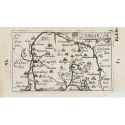
VI. Carte du Brabant ou se trouv.t les envir.s d'Eyndhoven..
Nice small map illustrating part of southeastern Noord Brabant. With Eindhoven and Helmond in center of map.From Atlas Portatif Universel, by Robert de Vaugondy. Unrecord...
Date: Paris, later than 1748
Selling price: ????
Please login to see price!
Sold
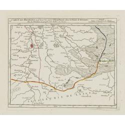
III. Carte du Brabant ou se trouvet le Maesland, la Seigneurie de Ravenstein, la Terre de Cuyck &c.
Nice small map illustrating a stretch of the river Meuse, flowing besides Alphen, Grave and Gennep.From Atlas Portatif Universel, by Robert de Vaugondy. Unrecorded state ...
Date: Paris, later than 1748
Selling price: ????
Please login to see price!
Sold
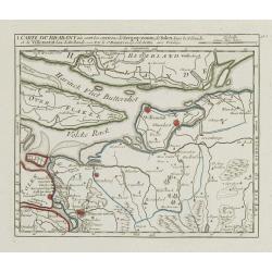
II. Carte du Brabant où sont les environs de Bréda, et de Bosleduc.
Nice small map illustrating part of North Brabant. Extending West to East from Breda to ?s-Hertogenbosch.From Atlas Portatif Universel, by Robert de Vaugondy. Unrecorded ...
Date: Paris, later than 1748
Selling price: ????
Please login to see price!
Sold
A New Plan of the Town of Bois le Duc and Its Fortifications.
Striking engraved plan showing the city of s'Hertogenbosch in Brabant, Netherlands. The map focuses on the town fortifications and also includes details of the town plan...
Date: London, J. Nourse, 1750
Selling price: ????
Please login to see price!
Sold in 2018
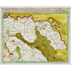
Partie septentrionale du duche de Brabant
A handsome map of the Northern half of Brabant, includes the area north of Mechelen. Includes a decorative title cartouche and a set of scales.Relief shown pictorially.
Date: Paris 1752
Selling price: ????
Please login to see price!
Sold
