Browse Listings in Europe > Netherlands
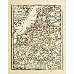
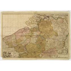
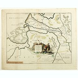
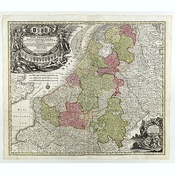
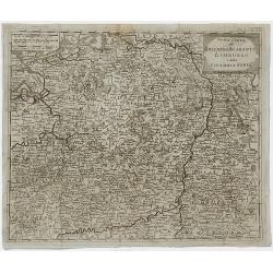
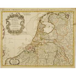
Les XVII Provinces Des Pays Bas..
Decorative map of the Low Countries, extending southwards as far as the North-East of France.From Le Nouveau et Curieux Atlas Geographique et Historique.. by Jacques Chiq...
Date: Paris, 1719
Selling price: ????
Please login to see price!
Sold in 2021
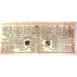
Carte Genealogique de la Maison de Nassau.
A fine, very detailed genealogical Map of the House of Nassau Orange. It is an antique engraving with the pedigrees of the House Nassau Wiesbaden and Nassau Dillenburg. T...
Date: Amsterdam, 1719
Selling price: ????
Please login to see price!
Sold in 2016
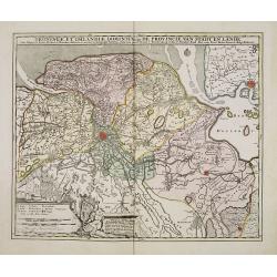
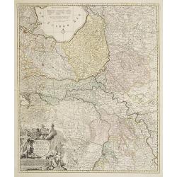
Groningae et Omlandiae Dominium vulgo De Provincie van Stadt en Lande, cum subjacent. Territ. Praefect. et Tractibus. [Lud Tjarda â Starckenburg. Nicol:Visscher. . .
Detailed map of the northern Dutch region of Groningen with figurative cartouche and coats of arms. The town of Groningen in the center, Emden just on the right. Engraved...
Date: Amsterdam, 1685/ 1720
Selling price: ????
Please login to see price!
Sold in 2017
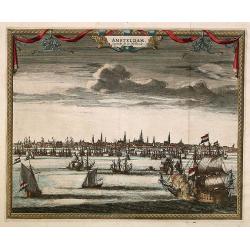
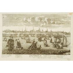
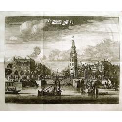
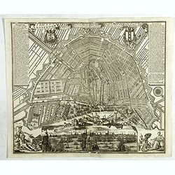
Amsterdam. Capitale de la Hollande.
A panoramic view of the town of Amsterdam seen from 't IJ.Rare.
Date: Leiden 1720
Selling price: ????
Please login to see price!
Sold
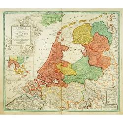
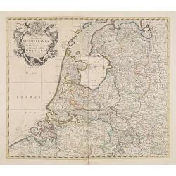
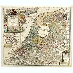
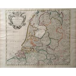
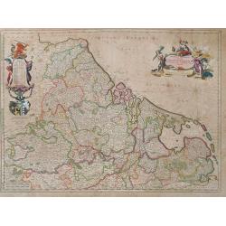
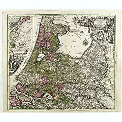
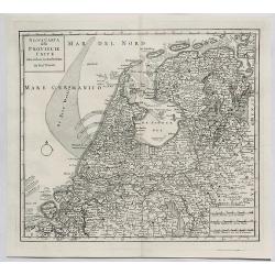
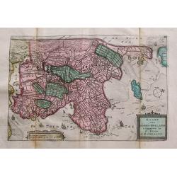
Belgii pars Septentrionalis vulgo Hollandia..
A large, decorative -colored- title cartouche at top left. In an inset -122x140mm- under the title cartouche a small map of Southeast Asia with a panoramic view of the po...
Date: Nuremberg 1720
Selling price: ????
Please login to see price!
Sold
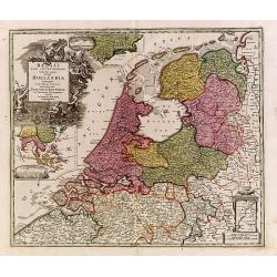
Belgii pars Septentrionalis vulgo Hollandia..
A large, decorative -colored- title cartouche at top left. In an inset -122x140mm- under the title cartouche a small map of Southeast Asia with a panoramic view of the po...
Date: Nuremberg 1720
Selling price: ????
Please login to see price!
Sold
Amsterdam Ville du Comte de Hollande.
A very RARE panoramic view of the city of Amsterdam, including a legend in the lower both corners.The plate is numbered in red pencil in upper right corner.Engraved by Je...
Date: Paris 1690-1720
Selling price: ????
Please login to see price!
Sold

Vue de la Ville de Delft.
A very fine and decorative view of the city of Delft. Includes a title in Dutch and French underneath.
Date: Amsterdam c.1720
Selling price: ????
Please login to see price!
Sold in 2019
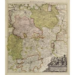
Brabantiae Ducatus
On the lower right a cartouche embellished with figures, trees, birds, fruits and the heraldic arms of Brabant, held by a female figure. At bottom a dedication to Herman ...
Date: Amsterdam 1720
Selling price: ????
Please login to see price!
Sold
Het groot en by naar geduurige schouwburg van den Europeeschen Oorlogh behelsende Brabant, Vlanderen, Henegouwe, Namur en Luyck, etc. te Amsterdam by P.Schenk.
Rare and interesting map of Brabant, and present-day Belgium. The wall map consists of two pages, pasted together and in top a separate printed slip with its title Het gr...
Date: Amsterdam 1720
Selling price: ????
Please login to see price!
Sold
Brabantiae Ducatus.
On the lower right a cartouche embellished with figures, trees, birds, fruits and the heraldic arms of Brabant, held by a female figure. At bottom a dedication to Herman ...
Date: Amsterdam, 1720
Selling price: ????
Please login to see price!
Sold in 2011
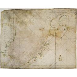
V.O.C. Chart of the Netherlands, south-eastern England and the English Channel.
V.O.C. manuscript vellum chart of the Netherlands, south-eastern England and the English Channel. Depicting the southern part of the North Sea, from the English Channel t...
Date: Amsterdam ca. 1720
Selling price: ????
Please login to see price!
Sold
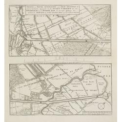
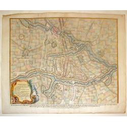
Nieuwe en nette afteekening van de door Gravinge die er Staat. . . Stadt Utrecht tot aan Spakenborg in de Zuyder Zee . . .
New and accurate map of the canal from the city of Utrecht to Spakenburg. The map was published in : Het groote tafereel der dwaasheid : vertoonende de opkomst, voortgang...
Date: Amsterdam, 1720
Selling price: ????
Please login to see price!
Sold
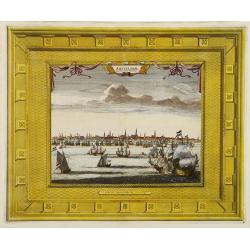
Amsterdam Capitale de la Hollande.
A panoramic view of the town of Amsterdam seen from 't IJ. Set within a decorative border, printed from a separate plate.Uncommon.
Date: Leiden, 1720
Selling price: ????
Please login to see price!
Sold in 2008
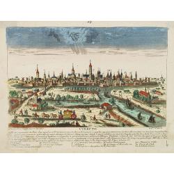
Utrecht.
A very RARE panoramic view of the city of Utrecht, including a numbered legend in the lower part.Engraved by Jean Crepy (the father) who was active as an engraver and pub...
Date: Paris, 1690-1720
Selling price: ????
Please login to see price!
Sold in 2008
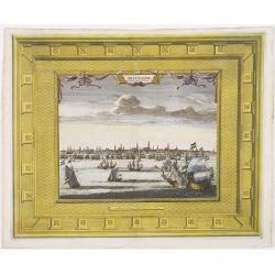
Amsterdam Capitale de la Hollande.
A panoramic view of the town of Amsterdam seen from 't IJ. Set within a decorative border, printed from a separate plate. Rare.
Date: Leiden, 1720
Selling price: ????
Please login to see price!
Sold in 2009
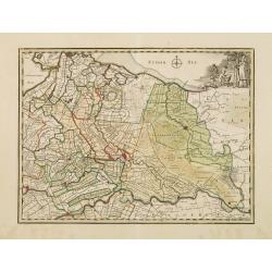
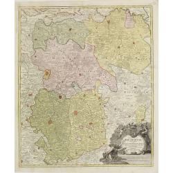
Tabula Nova Provinciae Ultrajectinae. . .
Prepared by Nicolas Visscher, now published by Petrus Schenk. Shows the land development in Gelderland, Holland, near the Zuyder Zee and it shows Arnhem, Doesburg, Zutphe...
Date: Amsterdam, 1720
Selling price: ????
Please login to see price!
Sold in 2014

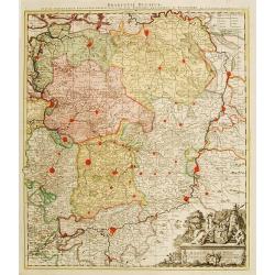
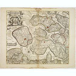
Drentia comitatus transisulaniae tabula II. . .
A map of Drente and part of Overijssel. The surveyor of this map is Cornelus Pynacker who made his survey in 1634, and the map was engraved by A. van den Broeck. This is ...
Date: amsterdam, 1720
Selling price: ????
Please login to see price!
Sold in 2013
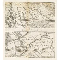
Nieuwe en nette aftekening van de door gravinge die er staat te geschieden beginnende van de stadt Utrecht tot aan Spakenborg in de Zuyder Zee. . .
New and accurate map of the canal from the city of Utrecht to Spakenburg on the Zuider Zee.A map taken from the first truly international speculative crisis in the histor...
Date: Amsterdam, 1720
Selling price: ????
Please login to see price!
Sold
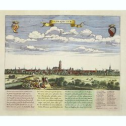
Ultrajectum (Utrecht)
A rare panoramic of Utrecht first published by Dancker Danckerts, here with a changed address. With a numbered key (1-23) to principal places in town and a poem in Latin...
Date: Amsterdam, (1660) c.1720
Selling price: ????
Please login to see price!
Sold in 2013
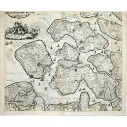
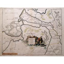
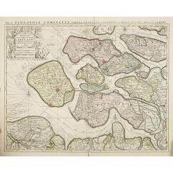
Comitatus Zelandiae tabula..
Fine map covering Zeeland, here in a re-issue by Covens and Mortier. Fine title cartouche and extensive shipping on Westerschelde and other waterways. Shows five islands:...
Date: Amsterdam, c.1720
Selling price: ????
Please login to see price!
Sold in 2014
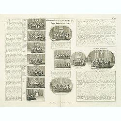
Gouvernement des etats des sept provinces Unies. . .
Print showing the infrastructure of the Dutch government, including the government of the separate provinces and the government of the state. The plate is adorned with a ...
Date: Amsterdam, ca. 1720
Selling price: ????
Please login to see price!
Sold in 2012
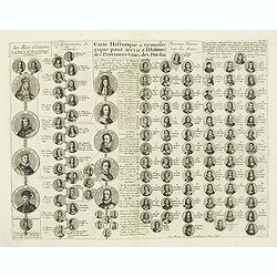
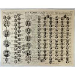
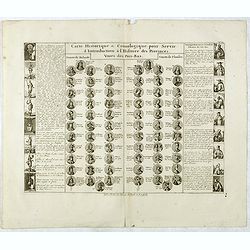
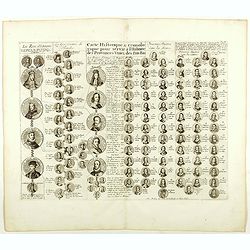
Carte historique & chronologique pour servir à l'histoire des Provinces-Unies des Pais-Bas. . .
Showing the genealogy of the ruling families of Europe who were allied with Holland at the beginning of the eighteenth century. Highly decorative, this impressive genealo...
Date: Amsterdam, ca. 1720
Selling price: ????
Please login to see price!
Sold in 2012
The Dutch Netherlands or the seven United Provinces. . .
Fine map of The Netherlands with decorative title cartouche. Engraved by S.Parker. Revised by John Senex.John Senex's A New General Atlas of the World was, strangely the ...
Date: London, 1720
Selling price: ????
Please login to see price!
Sold in 2013
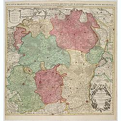
Ducatus Brabantiae, complrctens dominia Lovanii, Bruxellarum, Antverpia. . . / Carte du Brabant. . .
Covens & Mortier's map of Brabant, based upon De L'Isle's map of 1700. The North is orientated to the top side of the map. On the lower right a cartouche decorated wi...
Date: Amsterdam, 1720
Selling price: ????
Please login to see price!
Sold in 2013
Belgii pars Septentrionalis vulgo Hollandia. . .
A large, decorative colored title cartouche at top left. In an inset -122x140mm- under the title cartouche a small map of Southeast Asia with a panoramic view of the port...
Date: Nuremberg, 1720
Selling price: ????
Please login to see price!
Sold in 2014
Carte Genealogique de la Maison de Wassenaar ...
A magnificent large copper engraved chart, featuring the genealogy of the House of Wassenaar in Holland. There are four fine topographical engravings, and 41 coats of arm...
Date: Paris, 1720
Selling price: ????
Please login to see price!
Sold in 2016
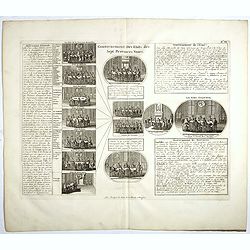
Gouvernement des etats des sept provinces Unies. . .
Print showing the infrastructure of the Dutch government, including the government of the separate provinces and the government of the state. The plate is adorned with a ...
Date: Amsterdam, ca. 1720
Selling price: ????
Please login to see price!
Sold in 2017
Carte genealogique de la maison des Wassenaar . . .
A magnificent large copper engraved chart, featuring the genealogy of the House of Wassenaar in Holland. There are four fine topographical engravings, and 41 coats of arm...
Date: Amsterdam, 1720
Selling price: ????
Please login to see price!
Sold in 2017
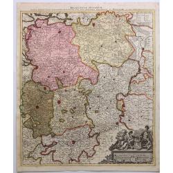
Brabantiae Ducatus.
A detailed map of the duchy of Brabant, now divided between the Netherlands and Belgium. Brussels and Antwerp are at left, Maestricht at right.On the lower right a cartou...
Date: Amsterdam, 1720
Selling price: ????
Please login to see price!
Sold in 2018
Carte Historique & Cronologique Pour Servir a L'Histoire des Provinces-Unis des Pais-Bas.
A wonderful genealogical chart and portraits of the rulers of the Netherlands, dating from Charles V in 1558 AD to William III of Orange, till 1702. From “Atlas Histori...
Date: Amsterdam, 1720
Selling price: ????
Please login to see price!
Sold in 2019
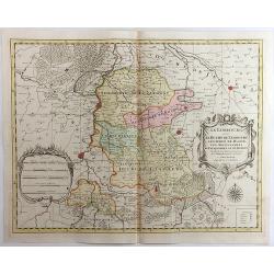
Le Limbourg, Le Duche de Limbourg, Le Comte de Dalem, Les Seigneures de Fauquemont et de Rolduc. . .
A fine and detailed map of Limburg and Dalem in the southern Netherlands. Based on the work of Nicholas Sanson, the map highlights the counties and lordships of Faquemont...
Date: Amsterdam, 1720
Selling price: ????
Please login to see price!
Sold in 2023
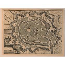
La Ville de Middelbourg.
A bird’s eye view of Middelbourg in the Netherlands, by Jacobus Harrewijn in 1720. Jacobus Harrewijn ( 1660–1727) was an engraver who was mostly active in the Souther...
Date: Brussels, 1720
Selling price: ????
Please login to see price!
Sold in 2020
La Ville de Harlem.
A bird’s eye view of Harlem in the Netherlands, by Jacobus Harrewijn in 1720. Jacobus Harrewijn (1660 – 1727) was an engraver who was mostly active in the Southern Ne...
Date: Brussels, 1720
Selling price: ????
Please login to see price!
Sold in 2020
The Dutch Netherlands or the Seven United Provinces Commonly Called Holland.
A map of the Northern part of the Netherlands by John Senex which depicts major cities, including Antwerp, Brugge and Breda, as well as main rivers and lakes in the regio...
Date: London, 1721
Selling price: ????
Please login to see price!
Sold in 2010
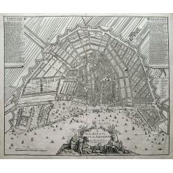
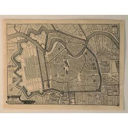
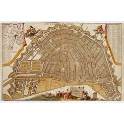
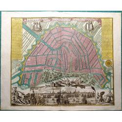
A new map of the city of Amsterdam. . .
A detailed and decorative plan of the city. With numerous streets, windmills, buildings, and sailing ships. 288 streets and 26 buildings are named in the legends. Decorat...
Date: London, 1721
Selling price: ????
Please login to see price!
Sold in 2018
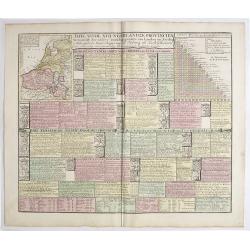
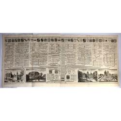
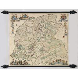
Tafel vande XVII Nederlandze Provincien, Vertonende der zelver verdeling, grootte van Landen en Steden, mids-gaders haar Regering, zo Politicq als Kerk-lyck, en veel andere merkweerdige zaken, ten nutte vande Historien en Geographie.
Interesting engraving, showing description and crests of the 17 Dutch provinces, the major cities and towns, political and religious diversity, trades, inventions and VOC...
Date: Amsterdam, 1724
Selling price: ????
Please login to see price!
Sold in 2019
Descriptio Agri Batavi Aliorumque qui hodie cis Rhenum in dicione VII Foedereratorum Auctore Mensone Alting.
Unusual map of Zeeland and Flanders with ancient names. With good detail on rivers and islands. Decorated with numerous warriors engaged in battle.
Date: Amsterdam, 1725
Selling price: ????
Please login to see price!
Sold in 2014
Descriptio Agri Batavi Aliorumque qui hodie cis Rhenum in dicione VII Foedereratorum Auctore Mensone Alting.
Unusual map of Zeeland and Flanders with ancient names. With good detail on rivers and islands. Decorated with numerous warriors engaged in battle.prepared by the Menso A...
Date: Amsterdam, 1725
Selling price: ????
Please login to see price!
Sold in 2018
![Comitatus Zelandiae Novissima Delineatio Per... Nun[c] Apud Pet. Schenck Jun.](/uploads/cache/91535-250x250.jpg)
Comitatus Zelandiae Novissima Delineatio Per... Nun[c] Apud Pet. Schenck Jun.
Detailed chart of islands in south west Netherlands with details shown pictorially.
Date: Amsterdam, 1726
Selling price: ????
Please login to see price!
Sold in 2010
Montalbaans Toren en Waterkeer.
Suberp view of the Montelbaanstoren in Amsterdam. Highly detailed print with buildings, people loading barrels, the watergate, and sailing ships.
Date: Amsterdam, 1726
Selling price: ????
Please login to see price!
Sold in 2012
Carte Historique & Cronologique pour Servir d'Introduction a l'Histoire des Provinces Unies des Pays-Bas.
This folio sheet shows a genealogical chart and portraits of the rulers of Holland and Flanders with descriptive French text, from Chatelain's monumental 7 volume "A...
Date: Amsterdam, 1728
Selling price: ????
Please login to see price!
Sold in 2016
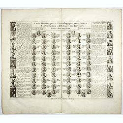
Carte Historique & Cronologique pour Servir d'Introduction a l'Histoire des Provinces Unies des Païs-Bas.
This folio sheet shows a genealogical chart and portraits of the rulers of Holland and Flanders with descriptive French text, from Chatelain's monumental 7 volume "A...
Date: Amsterdam, 1728
Selling price: ????
Please login to see price!
Sold in 2018
Carte Historique & Cronologique pour Servir d'Introduction a l'Histoire des Provinces Unies des Païs-Bas.
This folio sheet shows a genealogical chart and portraits of the rulers of Holland and Flanders with descriptive French text, from Chatelain's monumental 7 volume "A...
Date: Amsterdam, 1728
Selling price: ????
Please login to see price!
Sold in 2019
Ducatus Geldriae Nova Tabula In Tertachias Noviomagii, Arnhemii, Ruremondae in Zutphaniae Comitatum.
This is a uncommon re-issue of the copperplate of Nicolas Visscher. Including the area of Gelderland, Overijssel and Noord Limburg.Joachim Ottens (1663 - 1719) and his so...
Date: Amsterdam, 1730
Selling price: ????
Please login to see price!
Sold in 2020
Novissima et accuratissima XVII Provinciarum Germania Inferior Tabula.
Finely detailed map of the Netherlands by Frederick de Wit. A large legend cartouche is in the top left, is the family crest and dedication to John Munter, mayor of Amste...
Date: Amsterdam, 1730
Selling price: ????
Please login to see price!
Sold in 2010
Nova et accurata cominatus Zelandiae Tabula . . .
Fine and detailed map of the province of Zeeland. Originally issued by Cornelis Allard, now re-published with updated address by the Amsterdam publishers' Covens and Mort...
Date: Amsterdam, 1730
Selling price: ????
Please login to see price!
Sold in 2013
XVII Provinciae Belgii five Germaniae inferioris. . .
Decorative map of the Low Countries including Belgium, Luxemburg, the Netherlands, title surrounded by mythological figures and 17 coats of arms and 1 other cartouche low...
Date: Augsburg, 1730
Selling price: ????
Please login to see price!
Sold in 2018
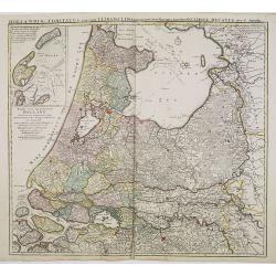
Tabula Comitatus Hollandiae in Praefecturas sua distributa, cui adjuncta est Provinc. Ultraiectina et maxima pars Geldriae summo studio delin. . .
Fine map of the provinces of North and South Holland. In upper left hand corner an inset with the islands of Texel and Vlieland. Just below the inset map a harbour scene ...
Date: Augsburg 1730
Selling price: ????
Please login to see price!
Sold in 2018
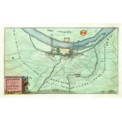
Beleg van Keizerswaart.
An attractive birds-eye-view of the siege of Keizersweert, published in the rare first edition of "Kleyne en Beknopte Atlas, of Tooneel des Oorlogs in Europa.."...
Date: Amsterdam 1735
Selling price: ????
Please login to see price!
Sold
Kaart van't Hertogdom Brabant.
Attractive map centered on the province of Brabant, including the maps of Venlo, Leuven, Roermond, Namur, Liege, Leeuw, Breda, Mechelen, Maastricht, s'Hertogenbosch, Antw...
Date: Amsterdam 1735
Selling price: ????
Please login to see price!
Sold

Oud gezigt van.. De Vijverberg, en 's-Gravenhof ..
"A very decorative view of the Vijverberg and ""Buitenhof"" in center of The Hague."
Date: The Hague 1736
Selling price: ????
Please login to see price!
Sold
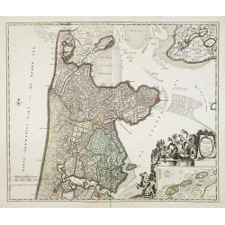
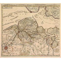
Hollandiae Septentrionalis & Frisiae Occidentalis. . .
Map of the Dutch region of North Holland between Amsterdam, Enkhuizen and Texel island. Large figurative cartouche and inset map of the islands Texel, Vlieland and Tersch...
Date: Amsterdam, ca. 1737
Selling price: ????
Please login to see price!
Sold in 2009
Nieuwe caert van Frieslant vermeerdert en verbetert op ordre en Gedeputeerde Staten door Bernard Schotanus à Sterringa vervaardigd en verbeterd door Johan Vegelin van Claerenbergen.
This very decorative wallmap - the so-called 'Vegelin-map' - is showing the Friesland counties, Oostergo, Westergo and Zevenwolden. The map is embellished with the coats ...
Date: Amsterdam, 1739
Selling price: ????
Please login to see price!
Sold
Uitrecht
Detailed map of the province of Utrecht. Including Amsterdam, Naarden, Amersfoort, Rhenen and Gouda. Fine title cartouche of Bishop and agricultural scenes.
Date: Amsterdam 1740
Selling price: ????
Please login to see price!
Sold

Nieuwe en Accurate Kaart van de Balluage van Amstelland.
Detailed map of the area south east of Amsterdam, including river Vecht and Muiden, Weesp, Loenen and Mijdrecht.
Date: Amsterdam 1740
Selling price: ????
Please login to see price!
Sold
Hollandiae comitatus una cum Ultrajectino Dominio nec non maximis partibus Geldriae Ducatus / per C. Specht. . .
Scarce map of the center of the Low Countries, with the provinces North and South Holland in full contemporary body colors, with inset map of Texel and Vlieland in upper ...
Date: Amsterdam, 1740
Selling price: ????
Please login to see price!
Sold in 2020

Plan dela Ville Academique et marchande de Leyden en Hollande..
Rare bird's-eye view of the town. At bottom detailed panoramic view with key.
Date: Augsburg 1740
Selling price: ????
Please login to see price!
Sold
Plan tres exact de la fameuse ville marchande d'Amsterdam..
Uncommon large scale plan of Amsterdam, with a key (A-X, 1-93) in upper right corner. and a key (94-139) and a map of the region of Amsterdam in upper left corner. In the...
Date: Amsterdam 1740
Selling price: ????
Please login to see price!
Sold
BRABANT
The Homann-family became the most important editors of atlases in Germany during the 18th. century. This map of Brabant shows the quarters: Louvain, Brussels, Antwerp, s...
Date: Nurnberg ca.1740
Selling price: ????
Please login to see price!
Sold

XVII Provincia Belgii five Germanie Inferioris.
Matthaus Seutter map showing regions of northern France, Belgium, Holland, England and Germany.
Date: Augsburg, 1730-1740
Selling price: ????
Please login to see price!
Sold in 2010

Ducatus Geldria Te Trachia Arnhemiensis Sive Velavia.
Detailed map covering Amersfoort, Elburg, Zwolle, Deventer, Zutphen, Doesburgh, Wageningen, etc.
Date: Amsterdam, 1740
Selling price: ????
Please login to see price!
Sold in 2022
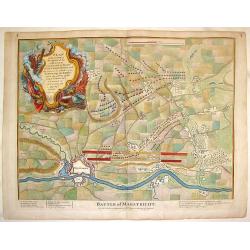
Battle of Maestricht, Plan of the Camp of the Allies.
Striking copper-engraved battle plan showing the battleground, fortifications, and troop placements during the War of the Spanish Succession. Stupendous, large, Rococo ti...
Date: London, 1740
Selling price: ????
Please login to see price!
Sold in 2014
![Haga Comitum, [Germ. Graven-Haag, Gall. la Haye] sedes ordinum Belgii foederati ichnographica...](/uploads/cache/38667-250x250.jpg)
Haga Comitum, [Germ. Graven-Haag, Gall. la Haye] sedes ordinum Belgii foederati ichnographica...
A beautiful and detailed plan of Den Haag (The Hague), in The Netherlands, with fine striking prospect of the town, as it was in the mid eighteenth century, below the pla...
Date: Nurenberg, ca. 1740
Selling price: ????
Please login to see price!
Sold in 2017
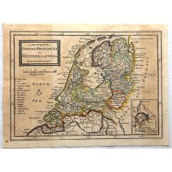
A New Map of the United Provinces of Netherlands.
Detailed map showing towns and cities, rivers, topography and the coastline and canals. An inset at lower right shows Limburg, the southern-most portion of present-day Ne...
Date: London, 1740
Selling price: ????
Please login to see price!
Sold in 2017
Amsterdam die Weltberuhmte Haupt-und Handel Statt in Holland auf das neuest und accurateste eintworffen und verlegt.
Birds-eye plan view of Amsterdam, depicting the city's architectural landmarks.Matthaus Seutter the elder first published his "Atlas Geographicus" in 1720 and a...
Date: Augsburg, ca. 1740
Selling price: ????
Please login to see price!
Sold in 2018
![Haga comitum [Germ Graven-Haag GallLA Haye] . . .](/uploads/cache/42506-250x250.jpg)
Haga comitum [Germ Graven-Haag GallLA Haye] . . .
A beautiful and detailed plan of Den Haag (The Hague), in The Netherlands, with fine striking prospect of the town, as it was in the mid eighteenth century, below the pla...
Date: Augsburg, ca. 1740
Selling price: ????
Please login to see price!
Sold in 2018
Nuova Carta del Ducato di Brabante Limburgo e della Gheldria Superre.
A fine map of the Duchy of Brabant and Limburg, Germany that appeared in "Novissimo Atlas published by Giovanni Albrizzi, a work based on the work of Isaak Tirion. I...
Date: Venice, 1740
Selling price: ????
Please login to see price!
Sold in 2020
Nuova Carta delle Provincie Unite. . .
A fine map of The Netherlands and Belgium by Tirion from his "Atlante Novissimo Che Contiene Tutte Le Parti Del Mondo...." This atlas was published in Venice an...
Date: Amsterdam, 1740
Selling price: ????
Please login to see price!
Sold in 2023
Plan of the Lines of Brabant.
Fine copper engraved plan featuring the 1705 battle in Brabant between the Duke of Marborough and Field-Marshall d'Averquerque. Decorative rococco cartouche with the expl...
Date: London, 1742
Selling price: ????
Please login to see price!
Sold in 2016
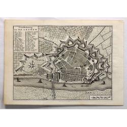
Grondtekening der Stad Arnhem.
A beautifully detailed plan of the fortress and surrounding area of Arnhem. A key identifies many gates, bastions and places. Arnhem is a city situated in the eastern par...
Date: Amsterdam, 1743
Selling price: ????
Please login to see price!
Sold in 2017

Grondtekening der Stad Schiedam.
A beautifully detailed plan of the fortress and surrounding area of Schiedam. A key identifies many gates, bastions and places.Schiedam is a city and municipality in the ...
Date: Amsterdam, 1743
Selling price: ????
Please login to see price!
Sold in 2018
Nieuwe kaart van de graafschap Zeeland. . .
Rare map of the Province of Zeeland, with its many islands and peninsulas. Major cities, small villages, and some of the natural features are named. Published by Reinier ...
Date: Amsterdam, c. 1744
Selling price: ????
Please login to see price!
Sold in 2009
Carte du Comté du Brabant, Dressée sur plusieurs Cartes particulières..
Map of the old Duchy of Brabant, which covers parts of the Netherlands and Belgium largely between the Meuse or Maas River and the North Sea. Highly detailed with depicti...
Date: Amsterdam c. 1745
Selling price: ????
Please login to see price!
Sold
Carte des Provinces Unies des Pays Bas..
Very fine large decorative early 18th century engraved folio sheet map of the Netherlands with original outline hand color. Highly detailed with depictions of topography...
Date: Amsterdam c. 1745
Selling price: ????
Please login to see price!
Sold
Kaart van Noord-Holland...
Interesting map of the northern part of the Netherlands. Oriented to the west. It extends from Amsterdam northward as far as Texel and southward as far as Enkhuizen. With...
Date: Amsterdam, c1745
Selling price: ????
Please login to see price!
Sold in 2014
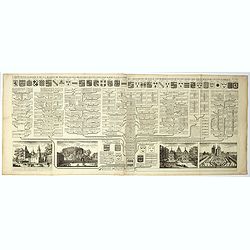
De Groote Nederlandse Stedenwyzer, vertoonende met een opslag des Oogs, de Afgelegentheden tussen 108 Steden, van de XVII. Nederlandse Provintien. . .
In upper right corner inset map of the Low Countries. The page is filled with a scale which shows distances between cities and provinces.
Date: Amsterdam, 1745
Selling price: ????
Please login to see price!
Sold in 2017
Amsterdam, die weltberuhmte Haupt - und Handel Statt in Holland (..)
A copper engraved map with original hand coloring. Overall size 55 x 68 cm. A beautifully engraved map of Amsterdam, with 2 coat-of-arms, 2 vignettes in the lower corner,...
Date: Augsburg, ca. 1745
Selling price: ????
Please login to see price!
Sold in 2017
Nieuwe Kaart .. Westelykste Gedeelte van Staats-Vlaanderen
Detailed map of the Westerschelde delta, including Zeeuws Vlaanderen. Isaac Tirion was born in Utrecht ca. 1705. He came to Amsterdam ca. 1725. Tirion published a number ...
Date: Amsterdam 1747
Selling price: ????
Please login to see price!
Sold
Tabula Generalis.. Provinciae XVII. Infer. Germaniae..
A decorative map with uncolored cartouche surrounded by the coats of arms of Brabant, Limburg, Luxembourg, Geldern, Holland, Zeeland, Zutphen, Flandria, Flanders, Artois,...
Date: Nuremberg 1747
Selling price: ????
Please login to see price!
Sold
