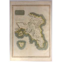
Attica.
This is an attractive 1814 John Thomson map of Attica, Greece. The map features many of the important cities and sites in early Greek History. It shows Athens, the Plain ...
Date: Edinburgh, 1815
Selling price: ????
Please login to see price!
Sold in 2017
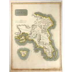
Attica.
An attractive map of Attica, in Greece. It features many of the important cities from early Greek History including: Athens, the Plain of Marathon, Salamis, and the islan...
Date: Edinburgh, 1816
Selling price: ????
Please login to see price!
Sold in 2016
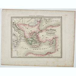
General Charte von der Europaischem Türkey
Nice map of Greece, Albania, etc by Johannes Walch.Johann Walch (1757-1824) was cartographer and map publisher active in Augsburg, he was the son-in-law of Johann Martin ...
Date: Augsburg, 1820
Selling price: ????
Please login to see price!
Sold in 2019

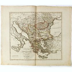
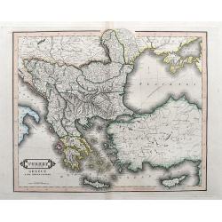
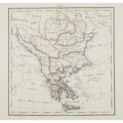
South Part of Turkey in Europe.
A map of Greece, showing Crete, Albania and Turkey. It was drawn & engraved for Thomson's "NEW GENERAL ATLAS" in Edinburgh in 1821.
Date: Edinburgh, 1821
Selling price: ????
Please login to see price!
Sold in 2016

L'ungheria e la turchia Europea. . .
Charming map of Hungary, Macedonia, Bulgaria and Greece from the rare atlas Atlante Tascabile o sia Serie di Num. XXI Cartine Geografiche nelle quali si rappresenta in ri...
Date: Rome, 1823
Selling price: ????
Please login to see price!
Sold in 2011

Carte Générale de la Turquie d'Europe et de la Grèce. . .
Map of Greece, including the regions of Romania, Bulgaria, Bosnia, Servia and part of the Black Sea with the western part of Turkey including Constantinople. Published a...
Date: Paris, 1827
Selling price: ????
Please login to see price!
Sold in 2011
Grecia Antiqua . . .
Detailed map of Ancient Greece, prepared by A. H. Basset, rue Saint-Jacques, no. 64, Paris and published in Atlas classique et Universel de Géographie . . . .The engrave...
Date: Paris, A.H. Basset, 1828
Selling price: ????
Please login to see price!
Sold in 2022
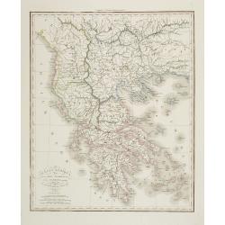
Turkey in Europe, Greece & the Ionian Islands.
A scarce and a highly detailed map of Turkey and Greece. Includes the Balkans, Cyprus, Crimea and the Black Sea. An attractive example.
Date: Edinburgh, ca 1835
Selling price: ????
Please login to see price!
Sold in 2020

Turquie d' Europe. (Greece)
Detailed map of Greece.From Malte-Brun's Atlas Géographie Universelle.. ., revised by Jean Jacques Nicolas Huot.This very fine executed map has been printed by Fosset an...
Date: Paris, 1837
Selling price: ????
Please login to see price!
Sold in 2013

Turkey in Europe.
A large steel engraved map of Turkey in Europe, stretching from Croatia and Bosnia in the west across to the countries bordering the Black sea, southwards through mainlan...
Date: London, 1839
Selling price: ????
Please login to see price!
Sold in 2020

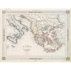
La Grèce et ses colonies.
Detailed map of Greece, prepared by Charles V. Monin (fl.1830-1880) a French cartographer of Caen and Paris. Published in Atlas Universel de Géographie Ancienne &c M...
Date: Paris, 1845
Selling price: ????
Please login to see price!
Sold in 2020
La Gréce et ses colonies.
Decorative map of Greece after A.H.Dufour, prepared by J.G.Barbié du Bocage.Engraved by Ch.Smith, published by Basset who was established in Paris, rue de Seine 33. From...
Date: Paris 1846
Selling price: ????
Please login to see price!
Sold

PALICAR. (Iles de l'archipel grec). Costumes Syriens 8.
A beautiful hand colored lithograph of a Palicar published in the French work "Galerie Royale de Costumes peints d´après nature par divers artistes et lithographi�...
Date: Paris, Chez Aubert & Cie., 1842-1848
Selling price: ????
Please login to see price!
Sold in 2017
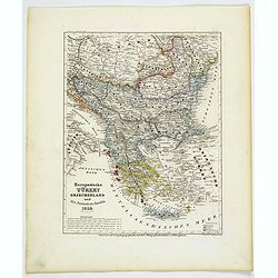
Europaeische Turkey, Griechenland und die Ionischen Inseln.
A steel-engraved outline hand color map Turkey in Europe, color-coded by region, with an explanation box lower right corner. An interesting historical map showing the reg...
Date: Hildburghausen, 1850
Selling price: ????
Please login to see price!
Sold in 2021

Ionian Islands and Greece.
This is John Tallis’ pretty map of the Ionian Islands and Greece. The map is surrounded by a five delicate steel engraved vignettes, and the whole is surrounded by a de...
Date: London, 1851
Selling price: ????
Please login to see price!
Sold in 2018
Creta Insula sec. Stadiasmum Maris Magni.
Delicate map of ancient Crete, according to the "Stadiasmus Maris Magni", prepared by Karl Wilhelm Ludwig Muller (1813-1894) and published in "Geographi Gr...
Date: Paris, Ambrosio Firmin Didot, 1855
Selling price: ????
Please login to see price!
Sold in 2017

Scylacis Periplus. . .
Delicate map of ancient Greece and the West coast of Turkey according to the "Stadiasmus Maris Magni", prepared by Karl Wilhelm Ludwig Muller (1813-1894) and pu...
Date: Paris, Ambrosio Firmin Didot, 1855
Selling price: ????
Please login to see price!
Sold in 2017

Das Königreich Hellas oder Griechenland und die Republik der sieben Ionischen Inseln (Ephtánisos).
Large and highly detailed map extending from Corfu to Santorini. With Peloponnese, Euboia, Mykonos, Kythira, Zakynthos, and many others. Includes two inset maps of Athens...
Date: Weimar, 1858
Selling price: ????
Please login to see price!
Sold in 2017
Bacino del Mediterraneo ( Parte orientale) . . .
Uncommon map with the Mediterranean Sea, centered on Greece. With a key to tracks of different streamline routes, prepared by Francesco Costantino Marmocchi. Above the ma...
Date: Genova, Paolo Rivara fu Giacomo, 1858
Selling price: ????
Please login to see price!
Sold in 2021

Nouvelle carte Illustrée Turquie d'Europe et de la Grèce . . .
A most decorative mid 19th century map, in upper and lower part 12 vignettes giving a wealth of statistic and commercial information. With a color key . Beside Greeve the...
Date: Paris, Fatout, 1860
Selling price: ????
Please login to see price!
Sold in 2010
Turquie d'Europe.
Map of Greece, including Serbia, Bulgaria, Albania, Bosnia.
Date: France, ca. 1860
Selling price: ????
Please login to see price!
Sold in 2015
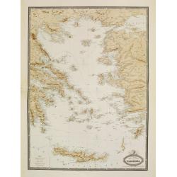
Carte Generale de L'Archipel.
Very detailed map from Atlas Sphéroïdal & Universel de géographie. Prepared by F.A.Garnier and edited by Jules Renouard, rue de Tournon, Paris. Uncommon map with d...
Date: Paris, 1861
Selling price: ????
Please login to see price!
Sold in 2022
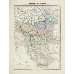
Pèninsule des Balkans.
Decorative map of the Balkan from Géographie Universelle, Atlas Migeon. published by J. Migeon. From one of the last decorative atlases published in the 19th century.
Date: Paris, 1874
Selling price: ????
Please login to see price!
Sold in 2017

Caligula's Palace and Bridge.
Fine hand-colored steel engraving by E. Goodall from a painting by the renowned J.M.W. Turner. It was published in 1875 by Appleton in New York. The engraving features &...
Date: New York, 1875
Selling price: ????
Please login to see price!
Sold in 2015

Map of Turkey in Europe. Illustrating the Berlin CongressTtreaty, July 1878.
An unusual map of Turkey, Greece, the Balkans, Austria and a part of the Ukraine, illustrating the nations created under the Berlin Congress Treaty, as well as the lands ...
Date: Philadelphia, 1878
Selling price: ????
Please login to see price!
Sold in 2021
![[Greece].](/uploads/cache/46170-250x250.jpg)
[Greece].
A detailed map of Greece published by the very successful St. Petersburg publisher "Cartographic institution A.Ilina".Alexey Afinogenovich Ilyin was a lieutenan...
Date: St. Petersburg, 1899
Selling price: ????
Please login to see price!
Sold in 2020
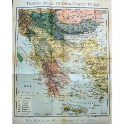
Teatro della guerra Greco-Turca.
Unusual map of South-East Europe with Greece, Romania, Bulgaria, and parts of Turkey. Coloring indicates the countries during the The Greco-Turkish War of 1919–1922. Pu...
Date: Milan, c. 1925
Selling price: ????
Please login to see price!
Sold in 2017

Rodi. Rhodes. Rhodos
Pictorial map of Rhodes, the island of the sun or rose island in Greece. Signed by Egon Huber Rodi 1935 on lower right. On upper right: Rodi, Rhodes, Rhodos, Rhodus. Show...
Date: Italty, 1935
Selling price: ????
Please login to see price!
Sold in 2021

Creta Candia
Unique manuscript map of Crete. Award-winning manuscript card, prepared by Antonio Raggio for the 11th Congreso de la Union Postal Universal (World Postal Congress) Expos...
Date: Buenos Aires, 1939
Selling price: ????
Please login to see price!
Sold in 2023
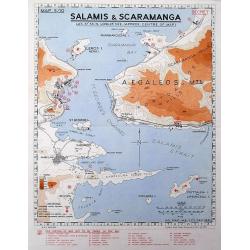
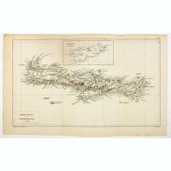
Salamis & Scaramanga.
A "Secret" map was printed by the South African Survey Co, in December 1941, after the German invasion of Greece. Shows a portion of the Saronic Gulf with the S...
Date: South Africa, 1941
Selling price: ????
Please login to see price!
Sold in 2016
