Browse Listings in America > North America

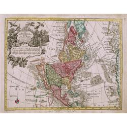
Hemisphere Septentrional pour voir plus.. les Terres..
The Covens & Mortier edition of this highly important map of the Northern Hemisphere. This work is the first to correctly place the west coast of North America by mov...
Date: Amsterdam, ca. 1730
Selling price: ????
Please login to see price!
Sold

Accurata delineatio....Gallice Louisiane ol. Cauad' et Floridae
Full title: Accurata delineatio celeberrimae Regionis Ludovicianae vel Gallice Louisiane ol. Cauad' et Floridae adpellatione in Septemtrionali America. A beautiful map of...
Date: Germany, 1730
Selling price: ????
Please login to see price!
Sold

Descripcion de las Yndias des Norte. 2.
Rare map of the Americas, one of the very few Spanish printed maps of America, first published in the 1601 first edition of Herrera's Historia General, the present map ap...
Date: Madrid, 1726, 1728, 1730
Selling price: ????
Please login to see price!
Sold in 2012

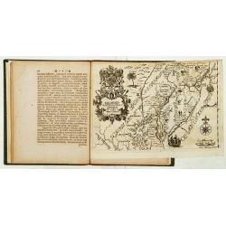
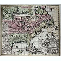
Nova Anglia Septentrionali Americae implantata Anglorumque coloniis florentissima ... Ioh. Baptista Homann Sac. Caes Maj ... Cum Privilegio ... .
This attractive map shows all of "Nova Anglia" (New England), most of "Nieuw Nederland" (present day New York), "Western and Eastern New Jarsey&...
Date: Nurnberg, c.1730
Selling price: ????
Please login to see price!
Sold in 2013

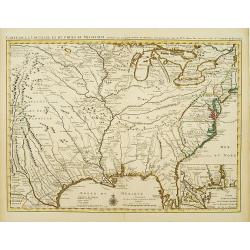
Carte de la Louisiane et du cours du Mississipi.
Shows Indian villages, "nations derangees, nations detruites," the route of de Soto, Moscoso, Cavelier, Tonty and Denis, etc. Relief shown pictorially. Covers a...
Date: Amsterdam, 1730
Selling price: ????
Please login to see price!
Sold in 2014

Carte du Canada ou de la Nouvelle France. . .
First issued by Guillaume Delisle in 1703, this important, detailed map provides the most accurate rendering of the Great Lakes of the time, with the lakes fully enclosed...
Date: Amsterdam, c.1730
Selling price: ????
Please login to see price!
Sold in 2019
Delineatis Pennsylvaniae et Caesereae nov. Occidebt seu West Niersey in America.
An extremely rare map of Pensylvania and New Jersey engraved by Jonas Silfverlong. Published in a publication by Tobias Biorck titled Dissertatio Gradualis, de Plantation...
Date: Upsula 1731
Selling price: ????
Please login to see price!
Sold

The Isle of California, New Mexico, Louisiane, The River Misisipi and the Lakes of Canada.
Printed in London, 1732. From Herman Moll's "A System of Geography." A scarce and remarkable map of California.California is as an island, with over a dozen pla...
Date: London, 1732
Selling price: ????
Please login to see price!
Sold in 2014

A Map of the British Empire in America (Southeastern Section of Popple Map Sheet 10)
>A Map of the British Empire in America with the French, Spanish and the Dutch Settlements adjacent thereto. Henry Popple's Map of the British Empire in America ma...
Date: London, 1733
Selling price: ????
Please login to see price!
Sold in 2023

Carte de la Louisiane et du Cours du Mississipi.
Carte de la Louisiane et du Cours du Mississipi." From Jean Frederic Bernard's Recueil de Voiages au Nord. Amsterdam: J.F. Bernard, 1734.This is a reduced-size editi...
Date: Paris, 1734
Selling price: ????
Please login to see price!
Sold in 2016
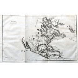
Amerique Septentrionale
A scarce copper engraving of colonial North America. The map shows the area from Greenland until the northern part of South America. Extends until California, but with la...
Date: Paris, 1734
Selling price: ????
Please login to see price!
Sold in 2021
Sheet 6 of 20: The Great Lakes and New Jersey.
One sheet of H.Popple's twenty-sheet survey of North America, in a first state, the first large-scale map of the British colonies in America. Featuring the Great Lakes in...
Date: London 1733-1735
Selling price: ????
Please login to see price!
Sold

Sheet 5 of 20: The Mississippi River system and its tributaries.
One sheet of H.Popple's twenty-sheet survey of North America, in a first stae, the first large-scale map of the British colonies in America. Featuring the Great Lakes in ...
Date: London 1733-1735
Selling price: ????
Please login to see price!
Sold

One sheet of 20: The coast from NovaScotia to Cape Cod and Nantucket.
One sheet of H.Popple's twenty-sheet survey of North America, in a first stae, the first large-scale map of the British colonies in America. Featuring the coast from Nova...
Date: London 1733-1735
Selling price: ????
Please login to see price!
Sold
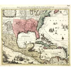
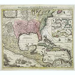
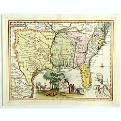
Mappa Geographica Regionem Mexicanam et Floridam.
It covers Central America with the Caribbean and the eastern part of the United States to the Great Lakes and New Mexico. In the lower-left is a beautiful picture of a na...
Date: Augsburg, 1735
Selling price: ????
Please login to see price!
Sold in 2013

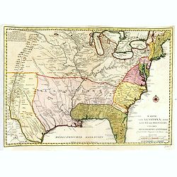
Accurata delineatio celeberrimae reg. Ludovicianae. . .
Includes the area from the Great Lakes to the Caribbean, in the center of the map the basin of the river Mississippi. In an inset part of Louisiana. With a very elaborate...
Date: Augsburg, 1735
Selling price: ????
Please login to see price!
Sold in 2010
Mappa Geographica Regionem Mexicanam et Floridam.
Covers Central America with the Caribbean and the eastern part of the United States to the Great Lakes and New Mexico. In lower left a beautiful picture of a naval battle...
Date: Augsburg, 1735
Selling price: ????
Please login to see price!
Sold in 2012

Accurata delineatio celeberrimae reg. Ludovicianae. . .
Includes the area from the Great Lakes to the Caribbean, in the center of the map the basin of the river Mississippi. In an inset part of Louisiana. With a very elaborate...
Date: Augsburg, 1735
Selling price: ????
Please login to see price!
Sold
Accurata delineatio celeberrimae reg. Ludovicianae. . .
Includes the area from the Great Lakes to the Caribbean, in the center of the map the basin of the river Mississippi. In an inset part of Louisiana. With a very elaborate...
Date: Augsburg, 1735
Selling price: ????
Please login to see price!
Sold in 2012

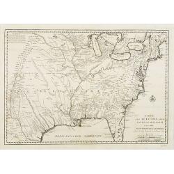
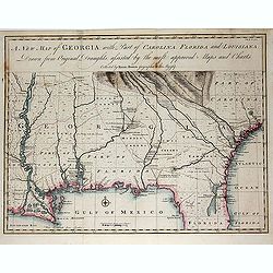
La Floride, suivant les Nouvelles Observations...
Fantastic map based on Delisle's important map of the southern United States of America, stretching from what is now Texas to Florida, and as far north as Tennessee and V...
Date: Amsterdam, 1735
Selling price: ????
Please login to see price!
Sold in 2014

A Map of the Coast of New England from Staten Island to the island of Breton. . .
From the first marine atlas produced in the colonies was drawn by Captain Cyprian Southack (1662-1745). He is of great importance in North American cartography Of the fir...
Date: London, ca. 1735
Selling price: ????
Please login to see price!
Sold in 2017

A Map of the British Empire in America with the French Spanish and Hollandish Possessions adjacent thereto by Henry Popple.
This is the one-sheet key map from the Dutch edition. 22 insets and views of various harbors and sights. This example is the rare FIRST state of the edition published by ...
Date: Amsterdam, 1737
Selling price: ????
Please login to see price!
Sold in 2020

A map of the County of Savannah.
Rare map, published in the 1730s and 1740s in Halle, Germany by Samuel Urlsperger in his Ausfuhrliche Nachricht von den Saltzburgischen Emigranten..Why the map is entitle...
Date: Halle 1730- 1740
Selling price: ????
Please login to see price!
Sold

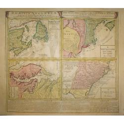
Dominia Anglorum in America Septentrionali/ Sie Gros-Brittanische Colonie Lænder in Nord-America. . .
Four maps on one sheet (Virginia und Maryland; Carolina nebsteinem Theil von Florida; New Engelland, New York, New Yersey und Pensilvania; and New Foundland, od. Terra No...
Date: Nuremberg, 1740
Selling price: ????
Please login to see price!
Sold in 2015

Virginia Marylandia et Carolina.
An attractive and detailed map, covering the coastline from Long Island in the north to just south of Cape Feare in Carolina, with the large fictitious Apalache Lacus in ...
Date: Augsburg 1740
Selling price: ????
Please login to see price!
Sold

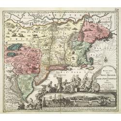
Recens edita totius Novi Belgii in America Septentrionali.
This most spectacular map, the last engraved in the sequence of maps based on the Janssonius' map of the area, shows a multitude of animals and birds and features a view ...
Date: Augsburg, ca. 1730-1740
Selling price: ????
Please login to see price!
Sold

Virginia Marylandia et Carolina.
An attractive and detailed map, covering the coastline from Long Island in the north to just south of Cape Feare in Carolina, with the large fictitious Apalache Lacus in ...
Date: Augsburg, 1740
Selling price: ????
Please login to see price!
Sold
Dominia Anglorum in America Septentrionali.
Four maps on one sheet (New Foundland/ New England/ Virginia and Carolina/Florida) based on J.B.Homann\'s map, showing British possessions in North America. At bottom of ...
Date: Nuremberg 1740
Selling price: ????
Please login to see price!
Sold in 2009
Recens edita totius Novi Belgii in America Septentrionali.
This most spectacular map, based on the Janssonius' map of the area. A wonderful cartouche adjacent to the title shows a long line of gods and natives bringing forth gift...
Date: Augsburg, 1730-1740
Selling price: ????
Please login to see price!
Sold in 2011

Recens edita totius Novi Belgii in America Septentrionali.
This most spectacular map, based on the Janssonius' map of the area. A wonderful cartouche adjacent to the title shows a long line of gods and natives bringing forth gift...
Date: Augsburg, ca. 1730 - 1740
Selling price: ????
Please login to see price!
Sold in 2013
Nova Orbis Sive America Septentrionalis.
Oddly shaped, early 18th century German map of North America, with California as an island. Decorative cartouche with native Americans and birds.
Date: Augsburg, c1740
Selling price: ????
Please login to see price!
Sold in 2014
![Grondvlakte van Nieuw Orleans, de Hoofdstad van Louisiana [with] De Uitloop vande Rivier Missisippi [and] De Oostelyke ingang van de Missisippi met een Plan van het Fort .](/uploads/cache/39133-250x250.jpg)
Grondvlakte van Nieuw Orleans, de Hoofdstad van Louisiana [with] De Uitloop vande Rivier Missisippi [and] De Oostelyke ingang van de Missisippi met een Plan van het Fort .
A sought after, highly attractive, decorative sheet that shows three maps arranged around a large compass rose. This work represents Tirion's version of a map that was fi...
Date: Amsterdam, 1740
Selling price: ????
Please login to see price!
Sold in 2017
Carta geographica della florida nelp americ settentrionale.
Map taken from "Atlante Novissimo", published by Giambattista Albrizzi around 1740. Based on Delisle, the map covers the region from Filadelfia south to the Bah...
Date: Venise, 1740
Selling price: ????
Please login to see price!
Sold in 2018

AMERICA SETTENTRIONAL di N. Sanson (California Island)
Very rare old outline color example of Nicolas Sanson's map of North America. California is depicted as an island; McLaughlin notes: "California with indented northe...
Date: NAPLES, ca 1740
Selling price: ????
Please login to see price!
Sold in 2020

Virginia Marylandia et Carolina. . .
An very attractive and detailed map, covering the coastline from Long Island in the north to just south of Cape Feare in Carolina, with the large fictitious Apalache Lacu...
Date: Augsburg, 1740
Selling price: ????
Please login to see price!
Sold in 2023

A new map of Virginia and Maryland.
Detailed folding map of the Chesapeake Bay region, showing towns, rivers, inlets, shoals, Islands, and other details. Predates the resolution of the Dispute between the P...
Date: London 1741
Selling price: ????
Please login to see price!
Sold
![[Gulf of Mexico showing entire Texas coast, and extending east to Florida]](/uploads/cache/37159-250x250.jpg)
[Gulf of Mexico showing entire Texas coast, and extending east to Florida]
Untitled sheets from Ottens’ important 6-sheet wall map: "Grand Théâtre de la Guerre en Amérique suivant les plus nouvelles observations des Espagnols, Anglois,...
Date: Amsterdam, 1741
Selling price: ????
Please login to see price!
Sold in 2016

Virginia, Maryland, Pennsilvania, East & West New Jarsey.
Important early English Chart of the Chesapeake and Delaware Bay region, based on a map by Augustine Hermann.Originally issued by John Thornton and William Fisher in 1689...
Date: London, ca 1742
Selling price: ????
Please login to see price!
Sold in 2013
![[7 sheets] A Map of the British Empire in America with the French Spanish and Dutch Possessions adjacent thereto by Henry Popple.](/uploads/cache/38145-250x250.jpg)
[7 sheets] A Map of the British Empire in America with the French Spanish and Dutch Possessions adjacent thereto by Henry Popple.
Seven map sheets, uncut, the first six with colored borders and outline coloring, each approximately 515 x 498 images (550 x 664 mm). Including the preliminary key map, f...
Date: Amsterdam, 1742
Selling price: ????
Please login to see price!
Sold in 2017
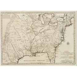
Karte von Luisiana, dem Laufe des Mississipi und den benachb
A rare German text edition of de l'Isles map of the Gulf region of the Mississippi. The European colonies and possessions along the Atlantic and Gulf coasts share importa...
Date: Paris 1744
Selling price: ????
Please login to see price!
Sold
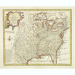
A new & accurate map of Louisiana, with part of Florida. . .
An English view of North America compiled from available French maps, especially those of Bellin used in Charlevoix's History of New Franc. English cartographers had litt...
Date: London, 1744
Selling price: ????
Please login to see price!
Sold in 2020

Carte des Embouchures du Mississipi.
This is a lovely chart of the mouth of the mighty Mississippi River, and her delta, as it empties into the Gulf of Mexico, about 75 miles south east of New Orleans. The c...
Date: Paris, ca 1744
Selling price: ????
Please login to see price!
Sold in 2020
Carte de la Louisiane et du Cours du Mississipi Dressée sur un grand nombre de Memoires..
Covens & Mortier's issue of Delisle's influential map of the French possession of Louisiana. Updated to include New Orleans. When originally published in 1718, it was...
Date: Amsterdam c. 1745
Selling price: ????
Please login to see price!
Sold

A new map of North America according to the newest observations..
A very fine map of North America, including the West Indies and northern South America.With Straits of Anian and Mozeemlek to north and Gulf of California to east., the B...
Date: London 1745
Selling price: ????
Please login to see price!
Sold

Carte de la Louisiane et du Cours du Mississipi Dressée sur un grand nombre de Memoires..
Covens & Mortier's issue of Delisle's influential map of the French possession of Louisiana. Updated to include New Orleans.When originally published in 1718, it was ...
Date: Amsterdam c. 1745
Selling price: ????
Please login to see price!
Sold

Carte d' Amerique Dressee pour l'Usage Du Roy. . .
Detailed copper-engraved map of Northern and Central America. Shows North America with colonial divisions and a wide open Northwest. The English settlements are confined ...
Date: Amsterdam c. 1745
Selling price: ????
Please login to see price!
Sold in 2018

Carte de la Louisiane et du cours du Mississipi . . .
Covens & Mortier's issue of Delisle's influential map of the French possession of Louisiana. Updated to include New Orleans.When originally published in 1718, it was ...
Date: Amsterdam, 1745
Selling price: ????
Please login to see price!
Sold in 2020

L'Amerique Septentrionale.
Interesting map of North America. In north eastern part of North America some interesting lakes and rivers are drawn, with a note: Terres vues par Tchirikow en 1741 . Tch...
Date: Paris, 1746
Selling price: ????
Please login to see price!
Sold in 2017
Karte von Luisiana, dem Laufe des Mississipi und den Benachbarten Laendern.
A rare German text edition of de l\'Isle\'s map of North America, focusing on the Mississippi and covering all the known United States, from the Rio del Norte (extending ...
Date: Leipzig, Arkstee & Merkus, 1746
Selling price: ????
Please login to see price!
Sold in 2008

Karte von Luisiana, dem Laufe des Mississipi und den Benachbarten Laendern.
A rare German text edition of de l'Isle's map of North America, focusing on the Mississippi and covering all the known United States, from the Rio del Norte (extending no...
Date: Leipzig, Arkstee & Merkus, 1746
Selling price: ????
Please login to see price!
Sold in 2015

Amérique Septentrionale.
2 x 2 joined sheets.
Date: Paris, 1746
Selling price: ????
Please login to see price!
Sold in 2009
Karte von Luisiana, dem Laufe des Mississipi und den Benachbarten Laendern.
A rare German text edition of de l'Isle's map of North America, focusing on the Mississippi and covering all the known United States, from the Rio del Norte (extending no...
Date: Leipzig, Arkstee & Merkus, 1746
Selling price: ????
Please login to see price!
Sold in 2019

Amerique Septentrionale Publiee sous les Auspices de Monseigneur le Duc d'Orleans Premier Prince du Sang. . .
A large map of North America and the West Indies that was one of the best French maps of North America prior to the French & Indian War. This map provides good inform...
Date: Paris, 1746
Selling price: ????
Please login to see price!
Sold in 2019

Particular Draughts and Plans of Some of the Principal Towns and Harbours Belonging to the English, French, and Spaniards, in America and West Indies
An unusual copper engraving by E. Bowen from 'A Complete System of Geography'. Featuring 13 small maps of colonial towns and sea ports of North America and the West Indie...
Date: London, 1747
Selling price: ????
Please login to see price!
Sold in 2010

A New and Accurate Map of Virginia & Maryland. Laid Down from Surveys and Regulated by Astronl. Observatns
Scarce map of the Chesapeake region by Bowen from 'A Complete System of Geography'. Based on Hermann's map of 1673 and Popple's map of 1733. Showing numerous early towns ...
Date: London, 1747
Selling price: ????
Please login to see price!
Sold in 2010

A New & Accurate Map of Louisiana, with Part of Florida and Canada, and the Adjacent Countries
Remarkable map of the British, Spanish & French Colonies in North America on the eve of the French & Indian War by E. Bowen from 'A Complete System of Geography'....
Date: London, 1747
Selling price: ????
Please login to see price!
Sold in 2011

A New and Accurate Map of New Jersey, Pensilvania, New York and New England with the Adjacent Countries
A scarce map of New Jersey, New York, Pennsylvania, Maine, New Hampshire and Connecticut by E. Bowen from 'A Complete System of Geography'. Covering the area from the Che...
Date: London, 1747
Selling price: ????
Please login to see price!
Sold in 2011

A New & Accurate Map of the Provinces of North & South Carolina Georgia &c
Bowen's map of the Carolinas and Georgia from 'A Complete System of Geography'. Showing the area from the mouth of the Chesapeake Bay to St. Augustine and from Louisiana ...
Date: London, 1747
Selling price: ????
Please login to see price!
Sold in 2012

A new and accurate map of New Jersey, Pensilvania, New York and New England with the Adjacent Countries. . .
A scarce map of New Jersey, New York, Pennsylvania, Maine, New Hampshire and Connecticut. Canada extends south to the Pennsylvania border. Published by E. Bowen from &quo...
Date: London, 1747
Selling price: ????
Please login to see price!
Sold in 2018

A New and Accurate Map of Virginia & Maryland. Laid Down from Surveys and Regulated by Astronl. Observatns
Uncommon map of the Chesapeake region, including only a thin strip of southern Pennsylvania, which is named but with nothing identified. Published by Bowen from 'A Comple...
Date: London, c.1747
Selling price: ????
Please login to see price!
Sold in 2016

A new & accurate map of.. North & South Carolina, Georgia &c. c. Drawn from late Surveys and regulated by Astron.
An excellent early engraving of the American Southeast from the mouth of the Chesapeake to Northern Florida. Georgia occupies a very small area next to a large Florida. N...
Date: London, 1747
Selling price: ????
Please login to see price!
Sold in 2015

A New and Accurate Map of Virginia & Maryland.
Scarce map of the Chesapeake region by Bowen.
Date: London, c.1747
Selling price: ????
Please login to see price!
Sold in 2019

A New and Accurate Map of Virginia & Maryland. Laid Down from Surveys and Regulated by Astronl. Observatns
Scarce map of the Chesapeake region by Bowen from 'A Complete System of Geography'. Based on Hermann's map of 1673 and Popple's map of 1733. Showing numerous early towns ...
Date: London, c.1747
Selling price: ????
Please login to see price!
Sold in 2020

A New and Accurate Map of N. Jersey, Pensilvania, New York. . .
A scarce map of New Jersey, New York, Pennsylvania, Maine, New Hampshire and Connecticut. Canada extends south to the Pennsylvania border. Published by E. Bowen from A Co...
Date: London, 1747
Selling price: ????
Please login to see price!
Sold in 2021
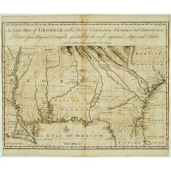
A New Map of Georgia with Part of Carolina, Florida and Loisiana..
Scarce and important early map of colonial Georgia. The map covers from Charles Town to the Mississippi River and extends into Florida to C. Canaveral. The coastal settle...
Date: London c.1748
Selling price: ????
Please login to see price!
Sold

Nouvelle Angleterre N.lle York N.lle Jersey Pensilvanie Mariland et Virginie.
Charming small map showing the eastern States between New England and Carolina, including part of the Great Lakes area.Number 98 outside border top right. Mary Sponberg P...
Date: Paris, 1748
Selling price: ????
Please login to see price!
Sold in 2008
A New Map of Georgia with Part of Carolina, Florida and Loisiana. . .
Scarce and important early map of colonial Georgia. The map covers from Charles Town to the Mississippi River and extends into Florida to C. Canaveral. The coastal settle...
Date: London c.1748
Selling price: ????
Please login to see price!
Sold in 2014

A Chart of the Pacific Ocean from the Equinoctial to the Latitude of 39 1/2d No.
This is a rare nautical chart of part of the Pacific Ocean displaying the routes of Spanish galleons between Acapulco and the Philippines. The tracks of the Spanish Nostr...
Date: London, 1748
Selling price: ????
Please login to see price!
Sold in 2017

A NEW and Accurate Map of the North Pole, with all the Countries hitherto Discovered. . .
A spectacular Arctic and sub-Arctic map, showing excellent detail around Hudson Bay area, Greenland, Spitzbergen & the Northeast Coast of Europe & Asia. It depict...
Date: London, 1748
Selling price: ????
Please login to see price!
Sold in 2021

Cours du Mississipi et La Louisiane. . .
Fine map depicting Mississippi delta and Great Lakes in upper right hand corner, from Atlas Portatif, Universel Et Militaire , first published in 1749.Map dated 1749.
Date: Paris, 1749
Selling price: ????
Please login to see price!
Sold in 2021

Partie du Mexique ou de la Nouv.le Espagne ouse trouve..
Fine miniature map of California Peninsular, Mexico till the Gulf of Mexico. Found in his Atlas Portatif, universel et militaire, 1749-1799.
Date: Paris 1749
Selling price: ????
Please login to see price!
Sold

Les Lacs du Canada et Nouvelle Angleterre.
Charming small map showing the Great Lakes region from Superior to Ontario and including the northern part of Pennsylvania below Lake Erie, although the state is not name...
Date: Paris, later than 1749
Selling price: ????
Please login to see price!
Sold

Cours du Mississipi et la Louisiane.
Nice small map showing the course of the Mississippi River, from Minnesota to the Gulf of Mexico.Number 92 outside border top right. Mary Sponberg Pedley does not mention...
Date: Paris, later than 1749
Selling price: ????
Please login to see price!
Sold in 2022
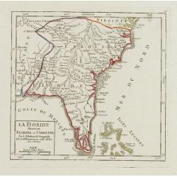
La Floride divisee en Floride et Caroline.
Nice small map representing the southeastern part of the United States, centred on Florida. It shows the Bahamas at the bottom.Number 93 outside border top right. Mary Sp...
Date: Paris, later than 1749
Selling price: ????
Please login to see price!
Sold

CALIFORNIA per P.Ferdinandum Con sak S.I. et alias.
Map of Mexico and the peninsular of California. Underneath the print a note about the region. Lower left a monogram E.V. of the engraver.
Date: c. 1750
Selling price: ????
Please login to see price!
Sold

Raccolta del Cotone.
Attractive view on a cotton plantation. The scene is explained through a key index on top.It represents black people at work for the Europeans' supplying of cotton and il...
Date: [No Title], ca. 1750
Selling price: ????
Please login to see price!
Sold

Plan de la Ville de Boston.
One of the earliest obtainable town plans of Boston and Charlestown, with an extensive index of 16 specific sites at left, each located on the map. Shows Boston 13 years ...
Date: Paris, 1750
Selling price: ????
Please login to see price!
Sold in 2008

L'AMERIQUE SEPTENTRIONALE Dressée sur les Relations les plus modernes des Voyageurs. . .
Scarce first edition of De Vaugondy's large map of North America. The Coast of California still includes Nlle. Albion, Quiviera and the entrance discovered by Martin d'Au...
Date: Paris, 1750
Selling price: ????
Please login to see price!
Sold in 2016

Vue de Salem. (reversed
A so-called optical print. A lively scene from the harbour of Salem with many people loading a vessel. Engraver: Balthazar Frederic Leizelt.
Date: Augsburg 1750
Selling price: ????
Please login to see price!
Sold in 2008

L'AMERIQUE SEPTENTRIONALE Dressée sur les Relations les plus modernes des Voyageurs. . .
Scarce first edition of De Vaugondy's large map of North America. The Coast of California still includes Nlle. Albion, Quiviera and the entrance discovered by Martin d'Au...
Date: Paris, 1750
Selling price: ????
Please login to see price!
Sold in 2008
