Browse Listings in America > North America
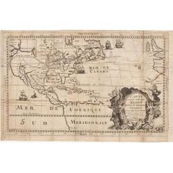
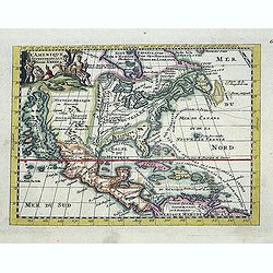
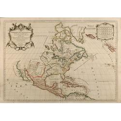
Carte d'un Nouveau Monde, entre le Nouveau Mexique et la Mer Glaciale ...
Map of America from Nouveau Voyage d'un Pays plus grand que l'Europe ... by R. P. Louis Hennepin, published in Utrecht in 1698.Based on his 1683 map Carte de la Nouvelle ...
Date: Utrecht, 1698
Selling price: ????
Please login to see price!
Sold in 2014

Nouveau Voyage d'un Pais Plus Grand que l'Europe.
FIRST EDITION OF THE BOOK. This edition of Hennepin's writings, a continuation of his Nouveau voyage of the previous year, comprises materials about La Salle taken from C...
Date: Utrecht, [E. Voskuyl for] Antoine Schouten, 1698
Selling price: ????
Please login to see price!
Sold

Carte D'un Nouveau Monde, entre le Nouveau Mexique, et la Mer Glacialle Novellement decouvert par le R.P. Louis Hennepin...
Extremely rare second edition of Louis de Hennepin’s map of North America, which incorporates many of the discoveries omitted by Hennepin in the first edition of his ma...
Date: Paris, 1698
Selling price: ????
Please login to see price!
Sold in 2021

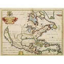
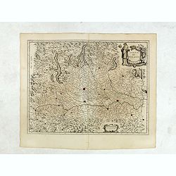
Repraesentatio Americae Borealis...
An interesting religious map of North America, showing the Catholic regions illuminated and the Protestant and still uncolonized lands swathed in darkness. California is ...
Date: Munich 1699
Selling price: ????
Please login to see price!
Sold

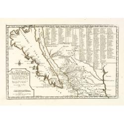
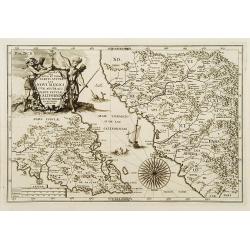
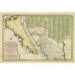
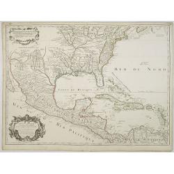
Cette Carte de Californie et du Nouveau Mexique ?
A most important map, identifying by numerical code some 314 places in New Mexico, and showing in detail California as an island, although based on Sanson's monumental ma...
Date: Paris, 1700
Selling price: ????
Please login to see price!
Sold in 2009
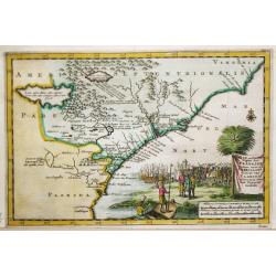
A new map of.. Plantations of the English in America..
"A boldly engraved large-scale map of the Carolinas, Nova Scotia, Bermuda, Barbados and Jamaica appear as large insets on this interesting uncommon and attractive ma...
Date: London 1700
Selling price: ????
Please login to see price!
Sold
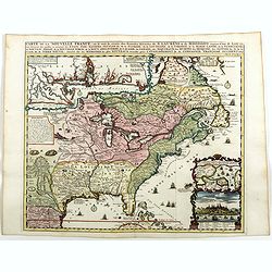
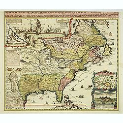
L'Amerique Septentrionale dressée sur les Observations de Mrs de l'Academie Royale des Sciences . . .
Rare third state of "L’Amerique Septentrionale. Chez l’Auteur sur le Quai de l’Horloge a la Cour. de Diamans avec Privilege du Roy pour 20 ans, 1700". &qu...
Date: Paris, 1700
Selling price: ????
Please login to see price!
Sold in 2018
Carver's new map of North America. . .
6 maps on a sheet Carver's map of North America, among other maps of Strait Anian.
Date: England, ca. 1700
Selling price: ????
Please login to see price!
Sold in 2020
Cette Carte de Californie et du Nouveau Mexique.
A most important map, identifying by numerical code some 314 places in New Mexico, and showing in detail California as an island, although based on Sanson's monumental ma...
Date: Paris, 1700
Selling price: ????
Please login to see price!
Sold in 2013
![Cette Carte DE CALIFORNIE et DU NOUVEAU MEXIQUE.[Rare 1st edition!]](/uploads/cache/83264-250x250.jpg)
Cette Carte DE CALIFORNIE et DU NOUVEAU MEXIQUE.[Rare 1st edition!]
Rare and important map of California ,New Mexico and New Spain, showing in detail California as an island [San Francisco, San Diego and Mendocino are mentioned among many...
Date: Paris 1700
Selling price: ????
Please login to see price!
Sold in 2021
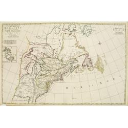
Carte Nouvelle de L'Amerique Angloise Contenant La Virginie, Mary-Land, Caroline, Pensylvania, Nouvelle Jorck, N. Jarsey, N. France..
A unique map of eastern North America with oversized Great Lakes. Pennsylvania includes both Delaware and eastern Maryland and almost bisects New York. Virginia includes ...
Date: Amsterdam c. 1700
Selling price: ????
Please login to see price!
Sold

Carte Particuliere de Virginie, Maryland, Pennsilvanie, La Nouvelle Jarsey. Orient et Occidentale.
Large scale, decorative map centered on Maryland and the Chesapeake Bay. Shown is an area from Staten Island in New York southward to Carratuck Inlet in North Carolina wi...
Date: Amsterdam c. 1700
Selling price: ????
Please login to see price!
Sold

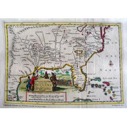
Carte Particuliere de la Caroline Dresse Sur les Memoires le plus Nouveaux.
Large, decorative map of today South Carolina centered on Charleston. The area represented extends from the South Edisto River northward to the Santee River. Illustrated ...
Date: Amsterdam 1700
Selling price: ????
Please login to see price!
Sold
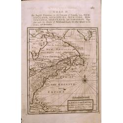
The ENGLISH EMPIRE in America.
Early English map of the British Colonies in North America from Herman Moll's 'A System of Geography' published in 1701. Compass Rose and rhumb lines with text on the rev...
Date: London, 1701
Selling price: ????
Please login to see price!
Sold in 2015

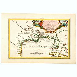
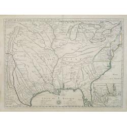
Les Costes aux Environs de la Riviere de Misisipi.
An historically important map of Florida and the Gulf Coast showing especially the estuary of the Mississippi in some detail, more or less correctly located.The locations...
Date: Paris, 1701
Selling price: ????
Please login to see price!
Sold in 2022
![Le Vieux Mexique ou NOUVELLE ESPAGNE avec les costes DE LA FLORIDE.[1st edition]](/uploads/cache/83258-250x250.jpg)
Le Vieux Mexique ou NOUVELLE ESPAGNE avec les costes DE LA FLORIDE.[1st edition]
The first edition of this interesting regional map of Florida, Texas, the Gulf Coast, the Southwest, Mexico and Central America, from the first edition of De Fer's Atlas ...
Date: Paris, 1702
Selling price: ????
Please login to see price!
Sold in 2020
L\'Amerique septentrionale. Noord America.
Map of North and Central America showing California as an island with indented coastline, and with place names R'Estiete, C.Blanco, P.de Carinde, Canal de S. Barbe, I. de...
Date: Amsterdam, 1702
Selling price: ????
Please login to see price!
Sold in 2013

Provinciae Borealis Americae non ita Pridem Detectae aut Magis ab Europaeis Excultae.
This captivating map of North America features a huge island of California, an oversized depiction of the Great Lakes, and a misplaced Mississippi River delta. The interi...
Date: Munich, 1702
Selling price: ????
Please login to see price!
Sold in 2012

America borealis 1699.
A map from the series of maps by the Jesuit mathematician. One of the two maps of North America from the series of about six of North America, produced by Scherer to show...
Date: Munich c.1702
Selling price: ????
Please login to see price!
Sold
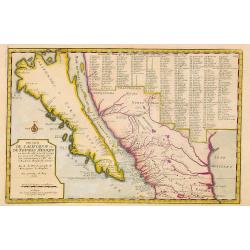
Delineatio Nova Et Vera Partis Australis Novi Mexici.
Attractive map of the Southern Portion of Baja California and contiguous Mexico, based in part on Scherer's correspondence with Fra. Eusebio Kino, the Jesuit Missionary c...
Date: Munich c.1702
Selling price: ????
Please login to see price!
Sold

Nova Svecia hodie dicta Pensylvania.
Very rare map shows the location of Swedish settlements on the Delaware River.Prepared by Peter Lindström in 1655, who made a map titled Nova Svecia, anno 1654 och 1655,...
Date: Stockholm 1702
Selling price: ????
Please login to see price!
Sold
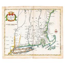
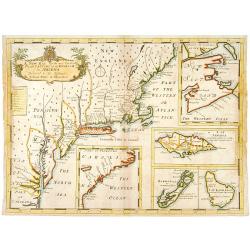
An Exact Mapp of New England and New York.
Recognized as the first 18th-century map of New England (Schwartz & Ehrenberg), this map was used to illustrate Cotton Mather's famous history of the Bay Colony, &quo...
Date: London: Printed for Thomas Parkhurst, 1702
Selling price: ????
Please login to see price!
Sold in 2023

Le Canada, ou Nouvelle France la Florida, la Virginie, Pensilvanie . . .
First edition. This fine map is showing the east coast of the United States from the Caribbean up to Newfoundland, with the western border just beyond the Mississippi.The...
Date: Paris, 1702
Selling price: ????
Please login to see price!
Sold in 2016

Pas-Kaart Vande Zee Kusten van Niew Nederland Anders Genaamt Niew York. . .
The first separate map of the Hudson River Valley, and the second printed of New York, Long Island and the southern New England coast. Based on original Dutch surveys ma...
Date: Amsterdam, 1682 - ca. 1702
Selling price: ????
Please login to see price!
Sold in 2013

Hemisphere Superieur du Globe Terrestre..
Rare map of Western Hemisphere shown in reverse, but text printed normally. World from internal viewpoint. California with indented northern coast. Terre de Jesso to Nort...
Date: Paris 1704
Selling price: ????
Please login to see price!
Sold

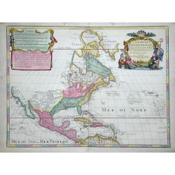
L'Amerique Septentrionale, ou la Partie Septentrionale des Indes Occidentales ou se Trouve le Canada ou Nouvelle France la Floride la Virginie les Isles Antilles le Nouveau Mexique et la Nouvele Espagne.
“Vincenzo Maria Coronelli’s large two-sheet ‘AMERICA SETTENTRIONALE,’ dated 1688, did not appear in an atlas until 1691, in the first edition of the ‘Atlante Ve...
Date: Paris, 1689-1704
Selling price: ????
Please login to see price!
Sold in 2013
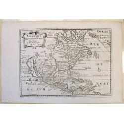
A New Map of North America Shewing its Principal Divisions, Chief Cities, Townes, Rivers, Mountains & c.
A boldly engraved map of North America, showing California as an island. This is a state 4. California as New Abion discovered by Sir Francis Drake Anno 1577 . Traci now ...
Date: London, 1704
Selling price: ????
Please login to see price!
Sold in 2018

A New Map of North America
Title: 'A New Map of North America Shewing its Principal Divisions, Chief Cities, Townes, Rivers, Mountains & c.'. A rare and interesting map of North America. Alth...
Date: London, 1704
Selling price: ????
Please login to see price!
Sold
Cette Carte de Californie et du Nouveau Mexique.
A most important map, identifying by numerical code some 314 places in New Mexico, and showing in detail California as an island, although based on Sanson's monumental ma...
Date: Paris, 1705
Selling price: ????
Please login to see price!
Sold

Sasquesahanok, Village palissade en Virginie, partie de l'Amerique/ Temple ou est l'Idole de Vens, adoree en Virginie/ Habillemens des Hommes et Femmes de Virginie
Copper engraving of Native Americans of Virginia by John Harris, from the: 'Navigantium atque Itinerantium Bibliotheca'; or, 'A Compleat Collection of Voyages and Travels...
Date: London, 1705
Selling price: ????
Please login to see price!
Sold in 2015

Le Canada, ou Nouvelle France la Florida, la Virginie, Pensilvanie . . .
Fine map is showing the east coast of the United States from the Caribbean up to Newfoundland, with the western border just beyond the Mississippi.The course of the Missi...
Date: Paris, 1705
Selling price: ????
Please login to see price!
Sold in 2020

Le Canada, ou Nouvelle France la Florida, la Virginie, Pensilvanie . . .
A fine map is showing the east coast of the United States from the Gulf of Mexico and the Caribbean up to Newfoundland, with the western border just beyond the Mississipp...
Date: Paris, 1705
Selling price: ????
Please login to see price!
Sold in 2021

Le Canada, ou Nouvelle France la Florida, la Virginie, Pensilvanie . . .
Fine map is showing the east coast of the United States from the Caribbean up to Newfoundland, with the western border just beyond the Mississippi.The course of the Missi...
Date: Paris, 1705
Selling price: ????
Please login to see price!
Sold in 2019

Nouvelle Carte de l\' Amerique Septentrionale dressee sur les plus Nouvelles Observations de Messieurs de l\' Academie des Sciences et des Meilleurs Geographes avec des tables tres instructives et curieuses de la division de tous les Etats.
From: Atlas Historique. A fine folio map with California as an island. All five of the Great Lakes are present; but Lake Erie is unnamed. The Ohio River is shown, but unn...
Date: Amsterdam, 1705
Selling price: ????
Please login to see price!
Sold in 2014

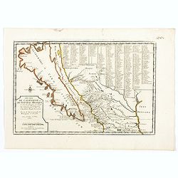
Cette Carte de Californie et du Nouveau Mexique.
A most important map, identifying by numerical code some 314 places in New Mexico, and showing in detail California as an island, although based on Sanson's monumental ma...
Date: Paris, 1705
Selling price: ????
Please login to see price!
Sold in 2019

Le Canada, ou Nouvelle France la Florida, la Virginie, ? Misispi
Fine map of the eastern coast of North America. Engraved by Herman van Loon, a Dutch engraver active in Amsterdam, after 1686 in Paris. ¤
Date: Paris, 1705
Selling price: ????
Please login to see price!
Sold in 2009
Cette Carte de Californie et du Nouveau Mexique. . .
A most important map, identifying by numerical code some 314 places in New MexicoIt shows in detail California as an island, although based on Sanson's monumental map of ...
Date: Paris, 1705
Selling price: ????
Please login to see price!
Sold in 2008
Cette Carte de Californie et du Nouveau Mexique.
A most important map, identifying by numerical code some 314 places in New Mexico, and showing in detail California as an island, although based on Sanson's monumental ma...
Date: Paris, 1705
Selling price: ????
Please login to see price!
Sold in 2015
Cette Carte de Californie et du Nouveau Mexique . . .
A most important map, identifying by numerical code some 314 places in New Mexico, and showing in detail California as an island, although based on Sanson's monumental ma...
Date: Paris, 1705
Selling price: ????
Please login to see price!
Sold in 2020
Les Costes aux Environs de la Riviere de Misisipi.
An historically important map of Florida and the Gulf Coast circa 1700 showing especially the estuary of the Mississippi in some detail, more or less correctly located.Th...
Date: Paris, 1705
Selling price: ????
Please login to see price!
Sold in 2021

Partie Meridionale de la Virginie et la .. Floride..
Uncommon map of Virginia and the Carolinas.
Date: Amsterdam 1706
Selling price: ????
Please login to see price!
Sold
![L'AMERIQUE SEPTENTRIONALE.[California island]](/uploads/cache/85225-250x250.jpg)
L'AMERIQUE SEPTENTRIONALE.[California island]
A map of North and Central America showing California as a hugh island stretching as far north as Alaska with indented coastline, and with the place names of: R'Estiete, ...
Date: Amsterdam, 1706
Selling price: ????
Please login to see price!
Sold in 2021

't Noorder Gedeelte van Virginie door Bartholomeus Gosnol en Martin Pringe uyt England bevaaren
Pieter van der Aa was a prolific publisher. He published a.o. ' Naaukeurige versameling der gedenkwaardigste zee- en land-reysen', a series of accounts of voyages (1706-0...
Date: Leiden, 1707
Selling price: ????
Please login to see price!
Sold in 2018
Zee en Land-Togten der Franszen Gedaan na, en in' t Americaans Gewest van Florida door Ioh. Pontius Ontdekt.
Pieter van der Aa was a prolific publisher. He published a.o. ' Naaukeurige versameling der gedenkwaardigste zee- en land-reysen', a series of accounts of voyages (1706-0...
Date: Leiden, 1707
Selling price: ????
Please login to see price!
Sold
T Amerikaans Gewest van Florida Door Ferdinand de Soto.
A scarce early 18th century Van Der Aa map of Florida with enormous boundaries covering all of southeastern America from Texas to Lake Erie. A decorative cartouche shows ...
Date: Leiden, 1707
Selling price: ????
Please login to see price!
Sold in 2017

Land en Volk-ontdekkingen in' t Noorder gedeelte van America door P. Marquette en Joliet gedaan in' t Jaar 1673.
An important map of the Mississippi river area, illustrating the voyage of Marquette and Joliet made in 1673. Embellished with a large and decorative title-cartouche, sho...
Date: Leiden, 1707
Selling price: ????
Please login to see price!
Sold in 2021

Zee en Land-Togten der Franszen Gedaan na, en in' t Americaans Gewest van Florida door Ioh. Pontius Ontdekt.
An antique map of Georgia and the North and South Carolina. Pieter van der Aa was a prolific publisher. He published a.o. 'Naaukeurige versameling der gedenkwaardigste ze...
Date: Leiden, 1707
Selling price: ????
Please login to see price!
Sold in 2021

' T noorder Deel van Amerika.
Pieter van der Aa was a prolific publisher. He published a.o. ' Naauwkeurge versameling der gedenkwaardigste zee- en land-reysen', a series of accounts of voyages (1706-0...
Date: Leiden, 1707
Selling price: ????
Please login to see price!
Sold

Jomathan Dickensons Ramspoedige Reystogt van Jamaika na Pensylvania Nagespond
A scarce Van Der Aa map of Florida and the Carolinas unusually oriented to the east and covering the Great Lakes to Jamaica. A very crisp copy in bright example.
Date: Leiden, 1707
Selling price: ????
Please login to see price!
Sold in 2016

Nieuw Engeland in Twee Scheepstogten door Kaptein Johan Smith in de Jaren 1614 en 1615 Bestevend.
Pieter van der Aa was a prolific publisher. He published a.o. ' Naaukeurige versameling der gedenkwaardigste zee- en land-reysen', a series of accounts of voyages (1706-0...
Date: Leiden, 1707
Selling price: ????
Please login to see price!
Sold

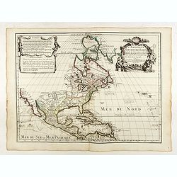
L'AMERIQUE SEPTENTRIONALE Dressée sur les Observations de Mr
One of the most influential maps of North America, laying the groundwork for much of the cartography of the 18th century. This is an early re-issue of De l'Isle's landmar...
Date: Paris, 1700 -1708
Selling price: ????
Please login to see price!
Sold in 2012

Carolina. / A map of.. Bermudos.
Two maps on one folding sheet. To the left a map of the Carolinas and to the right a map of Bermuda.This map by Herman Moll was published in the first edition of John Old...
Date: London 1708
Selling price: ????
Please login to see price!
Sold
L'Amerique Septentrionale. Dressée sur les Observations de Mrs. de l'Academie Royale des Sciences...
Attractive example of De L'Isle's very important map of North America, the first map to show California as a peninsula again. Further it has a better and a more accurate ...
Date: Paris, c1708
Selling price: ????
Please login to see price!
Sold in 2016

L'Amerique Septentrionale.
Uncommon issue of this decorative map of North America, covering Central America, showing east coast, California, Canada, Caribbean and northern part of South America. Sh...
Date: Amsterdam / Paris 1708
Selling price: ????
Please login to see price!
Sold

Nova Anglia Septentrionali Americae implantata ..
German interest in North America was high during the first half of the eighteenth century when Johan Baptiste Homann was the leading German cartographer. During this peri...
Date: Nuremberg, c.1710
Selling price: ????
Please login to see price!
Sold in 2011

North America corrected from the observations communicated to the Royal Society of London, and the Royal Academy at Paris...
Monumental and important large wall map of the Eastern part of North America with the United States, Central America, and the West Indies. Centered on the great lakes.1st...
Date: London, c 1710
Selling price: ????
Please login to see price!
Sold in 2008

Amerique Septentrionale.
Early and interesting map of North America with large blank parts and California as an island. Names a large Floride. Rey Coromedo Nouveau in todays Arizona, and Coste de...
Date: Paris, ca. 1710
Selling price: ????
Please login to see price!
Sold in 2019

Die vornehmste Eigenthums Herren und Befitzer von Carolina..
Complete title in cartouche lower right : Die vornehmste / Eigenthums Herren und Besitzer / von / CAROLINA. / Lord CRAVEN. / Hertzog von BEAVFORT. / Lord CARTERET. / ASHL...
Date: Hamburg, 1712
Selling price: ????
Please login to see price!
Sold in 2009

Die vornehmste Eigenthums Herren und Befitzer von Carolina..
Complete title in cartouche lower right : Die vornehmste / Eigenthums Herren und Besitzer / von / CAROLINA. / Lord CRAVEN. / Hertzog von BEAVFORT. / Lord CARTERET. / ASHL...
Date: Hamburg, 1712
Selling price: ????
Please login to see price!
Sold

Virginia Marylandia et Carolina in America Septentrionali Britannorum industria excultae. . .
Homann's important map intended to attract German emigration to America. It extends from New York City and Long Island south until present day Georgia, and as far west as...
Date: Nuremberg, ca 1714
Selling price: ????
Please login to see price!
Sold in 2019
Amerique Septentrionale.
Interesting 1715 quarto-size copy of Sanson's important map of North America, typically found in editions of L'Amerique published from 1656 to 1683. This copy from Chemer...
Date: Utrecht, 1715
Selling price: ????
Please login to see price!
Sold in 2015

NOVA ANGLIA Septentrionali Americae impantata Anglorumique coloniis florentissima. Geographice exhibita a Ioh. Baptista Homann...
An early map of the Northeast North America, extending north to include Maine and the St. Lawrence and south to include virtually all of New Jersey.In the early 18th cent...
Date: Nurmberg, 1716
Selling price: ????
Please login to see price!
Sold in 2017

Pas - Kaart Vande Zee Kusten inde Boght van Niew Engeland tusschen de Staaten Hoek en C. de Sable ...
Double page chart of the coastline and waters of New England from Cape Cod through to southern Nova Scotia. The chart with rhumb lines, compass roses and a ship illustrat...
Date: Amsterdam, Gerard van Keulen 1717
Selling price: ????
Please login to see price!
Sold in 2020

Carte de la Louisiane et du cours du Mississipi.
First issue, second state. First map to name New Orleans. This map is known for its detailed depiction of the states adjacent to the Gulf of Mexico region and the Mississ...
Date: Paris, 1718
Selling price: ????
Please login to see price!
Sold in 2008

Carte de la Louisiane et du cours du Mississipi.
First issue, first state. New Orleans not yet listed!. This map is known for its detailed depiction of the states adjacent to the Gulf of Mexico region and the Mississipp...
Date: Paris, Juin 1718
Selling price: ????
Please login to see price!
Sold in 2018
Carte du Mexique et de la Floride des Terres Angloises et des Isles Antilles du Cours et des Environs de la Riviere de Mississipi ... Par Guillaume Del\'Isle Geographe de l\'Academie Royale des Scieces.
Rare first edition, second state of the first printed map to accurately depict the course and mouth of the Mississippi River. De L\'Isle\'s Carte du Mexique is drawn from...
Date: Paris, 1703 / 1708-1718
Selling price: ????
Please login to see price!
Sold in 2009
Carte de la Louisiane et du cours du Mississipi.
First issue, first state. New Orleans not yet listed!. This map is known for its detailed depiction of the states adjacent to the Gulf of Mexico region and the Mississipp...
Date: Paris, 1718
Selling price: ????
Please login to see price!
Sold

Partie Meridionale de La Riviere de Missisipi..
The printed version of the most important map of the Mississippi Valley and Gulf of Mexico, prepared in manuscript by De L'Isle (Carte des Environs du Mississippi, 1701) ...
Date: Paris, 1718
Selling price: ????
Please login to see price!
Sold in 2013

Carte de la Louisiane et du cours du Mississipi.
First issue, first state (New Orleans not yet located) of “the first detailed map of the Gulf region and the Mississippi, [and] the first printed map to show Texas”(T...
Date: Paris 1718
Selling price: ????
Please login to see price!
Sold

Carte contenant le Royaume du Mexique et la Floride.
This is a derivative of Delisle's landmark map of the southern part of North America.The detailed map shows many English settlements along the East Coast and carefully no...
Date: Amsterdam, 1719
Selling price: ????
Please login to see price!
Sold

L'Amerique Septentrionale qui fait partie des Indes Occidentales..
A handsome miniature-map showing California as an island after Sanson. Sanson's details are generally followed.The British colonies are shown confined east of the Appalac...
Date: Paris, 1719
Selling price: ????
Please login to see price!
Sold in 2017
![Carte Qui Contient la Mantere don't se Fait La Chasse des Boeufs Sauvages et des Elans, Le Grand Saut de la riviere de Niagar a la danse du Calumet. . .[NIAGARA FALLS..]](/uploads/cache/83653-250x250.jpg)
Carte Qui Contient la Mantere don't se Fait La Chasse des Boeufs Sauvages et des Elans, Le Grand Saut de la riviere de Niagar a la danse du Calumet. . .[NIAGARA FALLS..]
A beautiful colored chart showing the Natives of Canada. A very unique sheet of various engravings concerning Native American customs and indigenous animals in North Amer...
Date: Paris, 1719
Selling price: ????
Please login to see price!
Sold in 2020

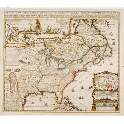
Carte De La Nouvelle France, ou se voit le cours des Grandes Rivieres de. S. Laurens & de Mississipi Aujour d'hui S. Louis, Aux Environs des-quelles se trouvent les Etats, Pais, Nations, Peuples &c. de la Floride, de la Louisiane, de la Virginie, de la M
Nice original old color rare single sheet map of the inhabited parts of North America. This map is based on the 4-sheet map by Nicholas De Fer which appeared in 1718.This...
Date: Paris, 1719
Selling price: ????
Please login to see price!
Sold in 2016
Carte de la Nouvelle France, ou se voi le cours. . .
Derived from de Fer's 1718 map, from west of the Mississippi it contains a mass of inland detail with notes and vignettes of the indigenous peoples and fauna of North Ame...
Date: Amsterdam, 1719
Selling price: ????
Please login to see price!
Sold
Amerique Septentrionale divisee en ses Principales Parties
Attractive map of North America. By Jaillot and Sanson. California between island and peninsula. Pacific Northwest is unexplored. Old outline color.
Date: 1719
Selling price: ????
Please login to see price!
Sold in 2010
Carte de la Nouvelle France, ou se voi le cours..
Derived from de Fer's 1718 map, from west of the Mississippi it contains a mass of inland detail with notes and vignettes of the indigenous peoples and fauna of North Ame...
Date: Amsterdam, 1719
Selling price: ????
Please login to see price!
Sold in 2022
![L'Amerique Septentrionale qui fait partie des Indes Occidentales . . . [California island]](/uploads/cache/85233-250x250.jpg)
L'Amerique Septentrionale qui fait partie des Indes Occidentales . . . [California island]
A fine example of the 1719 Chiquet's map of North America, with the accompanied related engraved French text sheet entitled "Description Abregé de l'Amerique Septen...
Date: Paris, 1719
Selling price: ????
Please login to see price!
Sold in 2021

Carte de la Nouvelle Franc où se voit le cours des Grandes Rivières de St Laurens et de Mississipi Aujourd'hui St Louis . . .
Derived from de Fer's 1718 map, from west of the Mississippi it contains a mass of inland detail with notes and vignettes of the indigenous peoples and fauna of North Ame...
Date: Amsterdam, 1719
Selling price: ????
Please login to see price!
Sold in 2012

Carte contenant le royaume du Mexique et la Floride.
From Chatelains Atlas Historique. Based upon De L'Isle's landmark map of the region.
Date: Amsterdam, 1719
Selling price: ????
Please login to see price!
Sold in 2009
Carte de la Nouvelle Franc, ou se voi le cours des grandes rivieres. . .
Derived from de Fer's 1718 map, from west of the Mississippi it contains a mass of inland detail with notes and vignettes of the indigenous peoples and fauna of North Ame...
Date: Amsterdam, 1719
Selling price: ????
Please login to see price!
Sold in 2017
