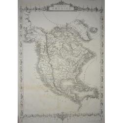
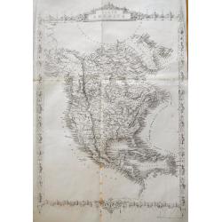
Browse Listings in America > North America

Vue Generale du Niagara a Vol d'Oiseau.
A spectacular view of Niagara Falls, the Horseshoe Falls in the foreground looking upstream towards Lake Erie. It was lithographed by Eugene Ciceri (1813 -90) after the v...
Date: Paris, ca 1851
Selling price: ????
Please login to see price!
Sold in 2021

Neueste Karte von Mississippi..
Detailed map of the state Mississippi with numerous physical and political features including mines, settlements, trails/roads, forts and Indian areas. From "Meijers...
Date: Hildburghausen/ Philadelphia 1852
Selling price: ????
Please login to see price!
Sold

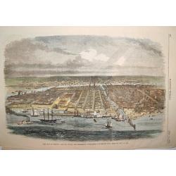
New Orleans from the Lower Cotton Press
A beautifully defined panoramic view of New Orleans as seen in the late 1840s / early 1850s. The harbor scene depicts numerous sailing ships, steamboats and other vessels...
Date: New York, 1852
Selling price: ????
Please login to see price!
Sold

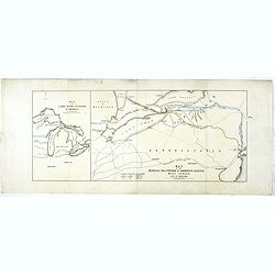
Die Staaten von New York, Pensylvania, Maryland, New Jersey.
Including the states of New York, Pennsylvania, Maryland, New Jersey, Delaware and Virginia. With inset plans of New York, Philadelphia, Niagara Falls, Albany, Pittsburgh...
Date: Hildburghausen & Philadelphia, 1852
Selling price: ????
Please login to see price!
Sold in 2011
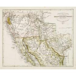
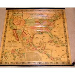
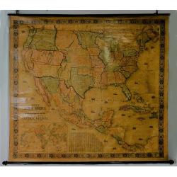
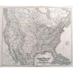
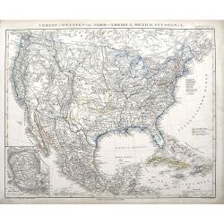
Vereinigte Staaten von Nord-America: Californien, Texas, und die Territorien New Mexico u. Utah.
Gold Regions tinted yellow. Very unusual combination of Texas and New Mexico configuration. California divided into ?Upper California?, which includes the Gold Regions an...
Date: Hildburghausen, 1852
Selling price: ????
Please login to see price!
Sold
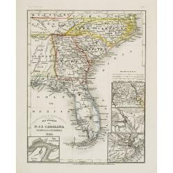
Die Staaten von N. & S. Carolina Georgia & Florida 1850.
Detailed map of Florida, North and South Carolina, with inset maps of St.Augustine, Newberne, Charleston and "Gold region von Nord -Carolina".Major ?roads? show...
Date: Hildburghausen, 1852
Selling price: ????
Please login to see price!
Sold
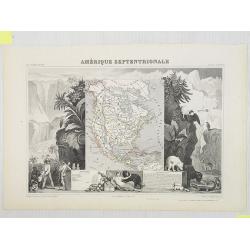
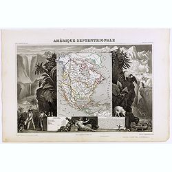
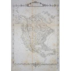
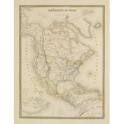
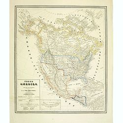
Amérique Septentrionale.
Map of North America showing the Republic of Texas, the United States extends into present-day Canada, Russia is in control of Alaska, and Mexico's northern border is acc...
Date: Paris, A. Combette, 1852
Selling price: ????
Please login to see price!
Sold in 2009
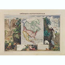
Amérique Septentrionale.
A very decorative map with the Republic of Texas, the United States extending into present-day Canada, Russia in control of Alaska, and Mexico's northern border according...
Date: Paris, A.Combette, ca. 1852
Selling price: ????
Please login to see price!
Sold in 2013
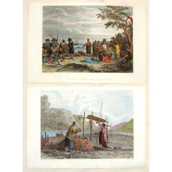
(2 Engravings) Interview of Massacoit with the Pilgrims and Feeding the Dead.
Two steel engravings featuring life among Native Americans in the early times. From "History of the Indian Tribes of the United States", published by Lippincott...
Date: Philadelphia, 1852
Selling price: ????
Please login to see price!
Sold in 2016
Amerique Septentrionale.
Beautiful map with the United States extending into present day Canada, Russia in control of Alaska and Mexico's northern border according to the Treaty of 1810. Surround...
Date: Paris, A. Combette, 1852
Selling price: ????
Please login to see price!
Sold in 2019

E and F (combined) Diagram of the State of Missouri.
Detailed land map of the state of Missouri, prepared by John G. Clark, William Dunn, William Shields and Aaron Snider and published by the Office of the surveyor general.
Date: Washington, 1852
Selling price: ????
Please login to see price!
Sold in 2021
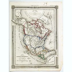
Carte de L'Amerique Septentrionale dresee et dessinee
An uncommon map of North America by J. G. Barbie du Bocage. It shows all of North America from the Arctic Circle to the northern most parts of South America. The US is sh...
Date: PARIS, 1852
Selling price: ????
Please login to see price!
Sold in 2020
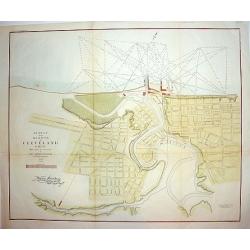
Survey of the Harbor of Cleveland Ohio..
An interesting and finely executed mid 19th century harbour survey and town plan of Cleveland. This lithographic work details the Cuyahoga River and topography of the cit...
Date: New York, ca 1853
Selling price: ????
Please login to see price!
Sold
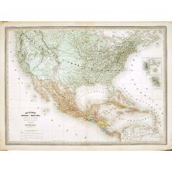
New Map of that Portion of North America Exhibiting..
Full title: New Map of that Portion of North America Exhibiting the United States and Territories, the Canada's, New Brunswick, Nova Scotia and Mexico, also Central Ameri...
Date: Baltimore 1853
Selling price: ????
Please login to see price!
Sold
Vereinigte Staaten von Nord America und Mexico
Famous German steel-engraved map of the United States and Latin America, published in Stieler's Schul-Atlas. Includes much topographical detail and curiously shaped state...
Date: Gotha, c. 1853
Selling price: ????
Please login to see price!
Sold

Posesiones de America : Isla de Cuba. . .
Wall size map of land areas showing all of Cuba, part of Florida Keys plus San Adios and Salvador Grande in the Bahamas.Minute topographical, political, and hydrographic ...
Date: Madrid, 1853
Selling price: ????
Please login to see price!
Sold in 2023
New Map of the Portion of North America, Exhibiting the United States and Territories, The Canadas, New Brunswick, Nova Scotia, and Mexico also Central America, and the West India Islands.
Possibly the most interesting and attractive 19th-century wall map of North America. Published in 1853 by Jacob Monk, this large and beautiful wall map details much of No...
Date: Baltimore, 1853
Selling price: ????
Please login to see price!
Sold in 2018

Agricultural Map of the State of New York.
A thematic map of New York State.
Date: New York, c. 1854
Selling price: ????
Please login to see price!
Sold in 2013
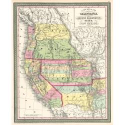
Map of the States of California, Washington, Utah, New Mexico, & Oregon Territories
This map by one of the leading U.S. cartographic firms of the period, is an excellent example of American mapping at an important time in the development of the western U...
Date: Philadelphia, 1854
Selling price: ????
Please login to see price!
Sold in 2023

Map of Louisiana Representing the Several Land Districts
A handsome and very uncommon map of Louisiana. The work is a detailed survey of the State's various land divisions. A 12 point reference table provides letter coding and ...
Date: Donoldsonville, Louisiana, dated 1855
Selling price: ????
Please login to see price!
Sold

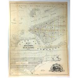
A Plan of the City of New York & its Environs to Greenwich.
A marvelous re-issue of Major John Montresor's famous and exceedingly scarce official plan of New York. This plan was specially commissioned by George Hayward in 1854 fo...
Date: New York, 1855
Selling price: ????
Please login to see price!
Sold
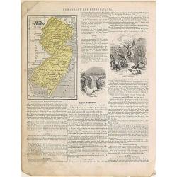
New Jersey.
From: System of Geography for the use of schools , published by Harper and brothers, 329 Pearl Street, New York.Page 37/38 from Sidney E. Morse's: System of Geography for...
Date: New York, 1855
Selling price: ????
Please login to see price!
Sold in 2015
Etats-Unis. . .
Very detailed map of the United States of America, prepared by Auguste Henri Dufour (1798-1865). From La Terre Atlas Historique et Universel de Geographique. Published in...
Date: Paris, 1855
Selling price: ????
Please login to see price!
Sold in 2020
North America.
Important and uncommon later edition by Rapkin based on Tallis' maps. The vignettes have been removed and the map is issued in black and white. With decorative borders an...
Date: London 1855
Selling price: ????
Please login to see price!
Sold
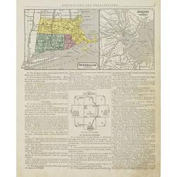
New England Southern Part.
Map of the southern part of New England specifically of Massachusetts, Connecticut and Rhode Island and Boston and its vicinities. On the verso, a world map of North and ...
Date: New York, 1855
Selling price: ????
Please login to see price!
Sold in 2015

Ohio and Indiana.
Map of Ohio and Indiana. On verso a map of Iowa, Illinois and Missouri. From Sidney E. Morse''s: System of Geography for the use of schools , published by Harper and brot...
Date: New York, 1855
Selling price: ????
Please login to see price!
Sold in 2011
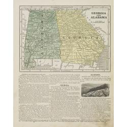
Georgia and Alabama.
Map of Georgia and Alabama. On verso a map of Louisiana, Mississippi and Arkansas. From Sidney E. Morse''s: System of Geography for the use of schools , published by Harp...
Date: New York, 1855
Selling price: ????
Please login to see price!
Sold in 2010
North America.
Important and uncommon later edition of Tallis map. The vignettes have been removed and the map is issued in black and white. Very detailed with numerous place names and ...
Date: London, c.1855
Selling price: ????
Please login to see price!
Sold in 2011

Michigan and Wisconsin
Map of Michigan and Wisconsin. Page 35/36 from Sidney E. Morse's: System of Geography for the use of schools , published by Harper and brothers, 329 Pearl Street, New Yor...
Date: New York 1855
Selling price: ????
Please login to see price!
Sold in 2011

Cavaliere Yuto e Capo Arrapohe & Capo Sioux Yanctons e Capo Ponkas. (2 prints)
Two chromolithograph prints of Native Americans including those from the Arrapoho and Ponka tribes. They are from an unidentified source by an anonymus artist. The publis...
Date: Rome, c.1855
Selling price: ????
Please login to see price!
Sold in 2016
North America.
Very detailed and up-to-date map of North America, from Russian America (Alaska) to Panama, including the West Indies. With numerous place names and Indian tribes! This ...
Date: London, ca. 1855
Selling price: ????
Please login to see price!
Sold in 2013
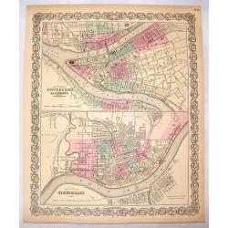
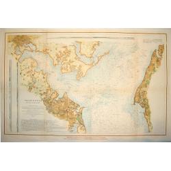
The Cities of Pittsburgh & Allegheny & The City of Cincinnati.
A hand-colored first edition of Colton's interesting two part map of Pittsburgh Pennsylvania and Cincinnati, Ohio. Interestingly, both maps are drawn to the same scale.
Date: New York, 1855
Selling price: ????
Please login to see price!
Sold in 2016
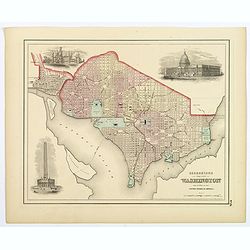
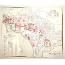
Georgetown and the City of Washington, the Capital of the United States of America.
An excellent 1855 example of Colton's plan of Washington D.C. and Georgetown. It covers the city in detail from Georgetown (Georgetown University, then College, shown) in...
Date: New York, 1855
Selling price: ????
Please login to see price!
Sold in 2018

New York Bay & Harbor. . .
The chart provides a fantastically detailed look at the Harbor of New York and environs. The chart includes detailed depth soundings, and has a directional rose.The chart...
Date: London, ca 1855
Selling price: ????
Please login to see price!
Sold in 2018
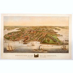
Bird's Eye View of the City of Annapolis, the Capitol of Maryland.
A wonderful large colored lithograph, by E. Sachse & Co., one of two important lithography companies operating in Baltimore during the mid nineteenth century, showing...
Date: Baltimore, ca 1855
Selling price: ????
Please login to see price!
Sold in 2020
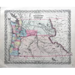
The Territories of Washington and Oregon.
Rare and early map of this region, in nice conditions.
Date: New York, 1855
Selling price: ????
Please login to see price!
Sold in 2022
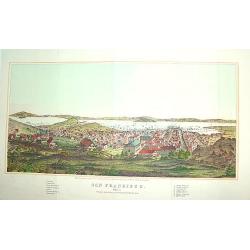
San Francisco
From Henry Bill's History of the World, a justly famous and sought after bird's-eye view of San Francisco published within seven years of the Gold Rush. It contains a leg...
Date: New York, 1856
Selling price: ????
Please login to see price!
Sold
PATAPSCO RIVER AND THE APPROACHES
A large and wonderfuly detailed U. S. government chart of the Patapsco River and shoreline areas, including a finely engraved plan of Baltimore. The work contains a wealt...
Date: Washington D. C. , dated 1856
Selling price: ????
Please login to see price!
Sold
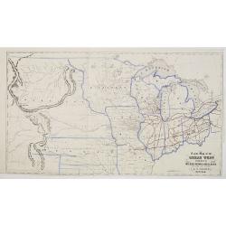
A New Map of the Great West Published by Miller, Orton & Mulligan, New York and Auburn. E. F. Beadle, Buffalo.
This map extends from Ohio to the Rocky Mountains, north of the Ohio River and Indian Territory, taken from "The States and Territories of the Great West", by J...
Date: Buffalo, 1856
Selling price: ????
Please login to see price!
Sold
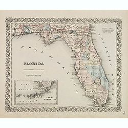
FLORIDA.
First edition. Issue with decorative borders. Fine map of Florida with smaller inset map "Plan of the Florida Keys". Of particular interest is the Arredondo Gra...
Date: New York, c. 1856
Selling price: ????
Please login to see price!
Sold in 2014
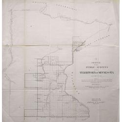
LOT OF 2: SKETCH OF THE PUBLIC SURVEYS IN THE TERRITORY OF MINNESOTA & SKETCH OF THE PUBLIC SURVEYS IN WISCONSIN AND TERRITORY OF MINNESOTA
Pair of lithographed maps of Minnesota and Wisconsin showing the Township boundaries for 1856. Included are rivers and towns.
Date: 1856
Selling price: ????
Please login to see price!
Sold in 2013
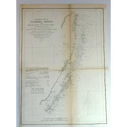
Preliminary Chart of Florida Keys from Key Biscayne to Pickles Reef
Detailed chart of Florida reefs with soundings. From a Trigonometrical Survey under the direction of A.D. Bache, Superintendent of the Survey of the coast of the United S...
Date: New York, 1856
Selling price: ????
Please login to see price!
Sold in 2018

Iron R.M. Steamship “Persia”_ Cunard Line - Currier
Fine colored lithograph or chromolithograph featuring the steamship Persia of the Cunard Line. It was produced in about 1838 by Currier & Ives and is signed in print ...
Date: New York, 1856
Selling price: ????
Please login to see price!
Sold in 2017
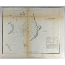
Reconnaissance of Steilacoom Harbor, Washington Ter.
Original lithograph of the U.S. Coast Survey map of Steilacoom Harbor, Washington Territory from 1856. It is from a trigonometrical survey under the direction of A.D. B...
Date: Washington, 1856
Selling price: ????
Please login to see price!
Sold in 2018
United States of America the British Provinces, Mexico...
Large engraved folding map surrounded by a decorative grapevine border interspersed with twelve insets and a large American eagle in front of a port. The map's coverage ...
Date: New York, 1856
Selling price: ????
Please login to see price!
Sold in 2019
Carta dell' America settentrionale.
Uncommon Italian map with the Republic of Texas, the United States extending into present-day Canada, Russia in control of Alaska. Map is in outlined color.Many Indian na...
Date: Turin 1857
Selling price: ????
Please login to see price!
Sold

Tracé d'une partie du Chemin de Fer de Galveston à Houston et Henderson. Texas Etats Unis D'Amerique.
Hand colored map of the area between Galveston, Harrisburg, Richmond and Houston, showing "Galveston, Houston & Henderson railroad", also "Buffalo Bayo...
Date: Paris, ca. 1857
Selling price: ????
Please login to see price!
Sold in 2010

Carte du Chemin de Fer de Galveston Houston & Henderson. Texas Etats Unis D'Amerique.
Hand colored map of the United States showing the "Galveston, Houston & Henderson" railroad system. The state of Texas is colored in pink and Illinois in bl...
Date: Paris, Imp. Kaeppelin, 17 Quai Voltaire, ca 1857
Selling price: ????
Please login to see price!
Sold in 2010

Private Signals of the Whaling Vessels Belonging to the Port of New Bedford.
Smaller (and maybe later?) edition of this important and rare publication, showing numerous flags of shipping companies, with the ships names. Lithograph with color, pub...
Date: New Bedford, c.1857
Selling price: ????
Please login to see price!
Sold in 2011
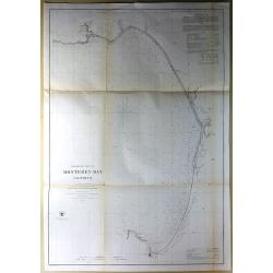
Preliminary Chart of Monterey Bay California.
Antique Electrotype Map, published in 1857 in Washington for the "Report of the Superintendent of the U.S. Coast Survey..." Published under the supervision and ...
Date: Washington, 1857
Selling price: ????
Please login to see price!
Sold in 2016

Grand Island Pass, Mississippi.
Antique Electrotype Map Published 1843-65, Washington for "Report of the Superintendent of the U.S. Coast Survey..." Published under the supervision and directi...
Date: Wahsington, 1857
Selling price: ????
Please login to see price!
Sold in 2016
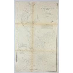
Preliminary Chart of Rappahannock River Virginia From Entrance to Deep Creek.
An informative large U.S. Coast Survey nautical chart of Virginia's Rappahannock River. It covers the course of the Rappahannock River from the Chesapeake Bay to Deep Cre...
Date: Washington, 1857
Selling price: ????
Please login to see price!
Sold in 2018

Sketch K Showing the Progress of the Survey in Section No. XI (Upper Sheet) from Tillamook Bay to the Boundary.
A fine 1857 US Costal Survey map, or triangulation chart, of Washington State, from Tillamook Head to Vancouver Island, including Juan De Fuca Strait, the Puget Sound, Ol...
Date: Washington, 1857
Selling price: ????
Please login to see price!
Sold in 2017

Mississippi Harbor.
Original lithograph of the U.S. Coast Survey map of Mississippi Harbor, Mississippi from 1857. It is from a trigonometrical survey under the direction of A.D. Bache Supe...
Date: Washington, 1857
Selling price: ????
Please login to see price!
Sold in 2018
L'Amérique du Nord.
Large map of North America with an inset of the Aleutians in the lower left corner.
Date: Paris, 1858
Selling price: ????
Please login to see price!
Sold in 2022
Map of the City & County of New York.
Detailed lithograph plan in two joined parts. The upper map details lower Manhattan up to 39th Street, and the lower map continuing the chart up to King's Bridge. There a...
Date: New York, 1858
Selling price: ????
Please login to see price!
Sold in 2017
Map of lakes Huron, superior & Michigan, on a smaller scale. / Map of the Buffalo, Brantford & Goderich railway west Canada with its connections
Two maps on one sheets. First map of "Map of lakes Huron, superior & Michigan, on a smaller scale." measuring 227 x 150mm. The map to the right "Map of...
Date: London, after 1858
Selling price: ????
Please login to see price!
Sold in 2020
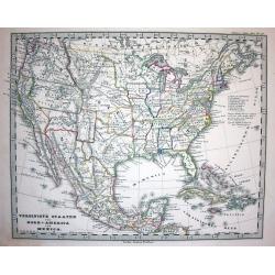
Die Vereinigten Staaten von Nord America nebst Canada.
A fascinating map of the United States, also parts of Canada and Mexico. Names several Territories and also Indian Territory. One of the most detailed maps of its time.
Date: Weimar, 1858
Selling price: ????
Please login to see price!
Sold in 2017
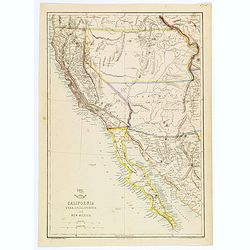
California, Utah, Lower California and New Mexico.
This is a British-produced map of the Southwest of the United States was included in the January 31, 1858 Sunday Supplement to the Weekly Dispatch newspaper. The map cove...
Date: London, 1858
Selling price: ????
Please login to see price!
Sold in 2018

Stati e territorii Occidentali della Unione Americana.
Rare map of the Transmississippi West, with an oversized California, Oregon, Nebraska, Kansas, New Mexico and Utah and a totally eclipsing Washington, Idaho, North & ...
Date: Genova, Paolo Rivara fu Giacomo, 1858
Selling price: ????
Please login to see price!
Sold in 2020

America Russa.
Uncommon map of Alaska prepared by Francesco Costantino Marmocchi. Above the map "Geografia Commerciale". From "Il Globo Atlante di carte Geografiche compi...
Date: Genova, Paolo Rivara fu Giacomo, 1858
Selling price: ????
Please login to see price!
Sold in 2020

Map of Louisiana Representing the Several Land Districts.
A very uncommon lithograph map of Louisiana. The work is a detailed survey of the State's various land divisions. A 12 point reference table provides letter coding and ic...
Date: Donoldsonville, 1859
Selling price: ????
Please login to see price!
Sold in 2013
Nord America mit Westindien.
A great map with a lot of interesting details: Nebraska extends to Canada and the Rocky Mountains. Kansas includes most of today's Colorado. Large Utah and New Mexico Ter...
Date: Weimar, 1859
Selling price: ????
Please login to see price!
Sold in 2017
Verein-Staaten von Nord-America, Mexico, Yucatan u. A.
An early edition of this interesting map. Very detailed and with very interesting geography, such as a large New Mexico but no Arizona. Also a large Utah territory, and a...
Date: Gotha, 1859
Selling price: ????
Please login to see price!
Sold in 2018
![North America [Sheet XV] Utah, New Mexico, Texas, California &c. . .](/uploads/cache/42397-250x250.jpg)
North America [Sheet XV] Utah, New Mexico, Texas, California &c. . .
A detailed steel engraved map of the American S.W. showing the states of California, New Mexico, Texas, Indian Territory (Oklahoma), Utah, Kansas and parts of Missouri, N...
Date: London, 1859
Selling price: ????
Please login to see price!
Sold in 2018

Chicago in 1820.
A fascinating steel engraving of early frontier Chicago, adapted from a sketch done by H. R. Schoolcroft. The view depicts indigenous Americans canooing on Lake Michigan ...
Date: Washington DC, ca 1860
Selling price: ????
Please login to see price!
Sold
Mexique Antilles, États-Unis..
Very detailed map of the United states. Engraved by Ch.Dyonnet, prepared by A.H.Dufour for his "Atlas Universele".
Date: Paris 1860
Selling price: ????
Please login to see price!
Sold
Plan von Washington 1845
A finely engraved plan of pre Civil War Washington D.C., as it was in 1845. There is an inset plan of the Capitol building, which was not yet built at the time. In additi...
Date: Heidelberg, 1860
Selling price: ????
Please login to see price!
Sold
The City of Chicago, Illinois, Where the Republican Convention will Meet on May 16, 1860.
A handsome woodcut pre-great-fire view of Chicago. The work depicts the city as seen in the late 1850s and centers on the Chicago River.Numerous sailing and steam vessels...
Date: New York, 1860
Selling price: ????
Please login to see price!
Sold

Vue de New York.
A view of New York over the bay with ships and boats as well as some people in the foreground. Probably after D. Fabronius and published by P. Cremetti in Brussels.
Date: Bruxelles 1860
Selling price: ????
Please login to see price!
Sold

Nouvelle Orléans.
A view of a part of the town of New Orleans, seen from the river with ships and boats in the foreground. After D. Fabronius (in the stone signed) and published by P. Crem...
Date: Bruxelles 1860
Selling price: ????
Please login to see price!
Sold

Vue de New York.
This scene includes careful renderings of the buildings in lower Manhattan and Brooklyn. Castle Garden, which was then an entertainment hall, is shown offshore of Battery...
Date: Paris 1860
Selling price: ????
Please login to see price!
Sold
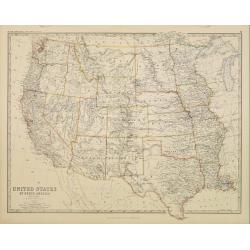
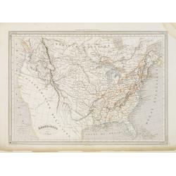
United States of North America. Western States.
Detailed map of western part of North America by Keith Johnston, a well-known publisher of maps who continually updated their regional maps. From his Royal Atlas . With g...
Date: Edinburg 1860
Selling price: ????
Please login to see price!
Sold
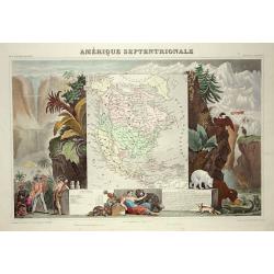
Amerique Septentrionale
Lovely map with an INDEPENDENT TEXAS. The United States extending into present day Canada, Russia in control of Alaska and Mexico's northern border according to the Treat...
Date: Paris 1860
Selling price: ????
Please login to see price!
Sold

Isba, Maison des colonies de l'Amérique Russe.
Early print of a colonial house in Alaska. Engraved by Ch.Ransonette and published by Arthus Bertrand. From: Voyage de M.D. de Mofras .Duflot de Mofras, an attaché of th...
Date: Paris, 1860
Selling price: ????
Please login to see price!
Sold in 2012
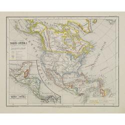
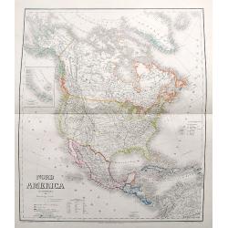
Noord-Amerika.
Uncommon map of North America including Canada and Mexico. Inset map of Central America. Lithography by J.H. van Weijer, published in Atlas der geheele Aarde [?] in 24 ka...
Date: Groningen, ca. 1860
Selling price: ????
Please login to see price!
Sold in 2008
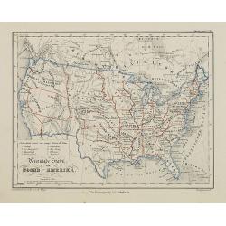
Vereenigde Staten van Noord-Amerika.
Uncommon map of the United States of America. Lithography by J.H. van Weijer, published in Atlas der geheele Aarde [?] in 24 kaarten.
Date: Groningen, ca. 1860
Selling price: ????
Please login to see price!
Sold in 2015

2 Papier peints: 'West Point in New York'' and ''Boston Harbor''.
Two panels from one of Zuber's grandest panoramic wallpapers (papier peint) is a set of American landscapes, "Les Vues de L'Amérique du Nord" (Views of North A...
Date: Rixham, ca. 1852 - 1860
Selling price: ????
Please login to see price!
Sold in 2011
Noord Amerika naar de bestebronnen vervaardigd onder toezigt van J. van Wijk Roelandsz. . .
A mid-nineteenth century map of America by the Dutch mapmakers and publishers Roelandsz and Zoon. Showing Alaska still belong to Russia.Engraved by J. Jaeger.
Date: Groningen, c. 1860
Selling price: ????
Please login to see price!
Sold in 2012
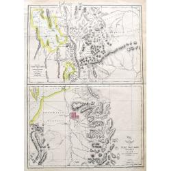
Map of the Great Salt Lake; The Great Salt Lake (Mormon) City;
Two important maps on one sheet showing Salt Lake City in Utah, and its surroundings. Both maps are very detailed, with many place names of rivers, settlements, springs, ...
Date: London, ca. 1860
Selling price: ????
Please login to see price!
Sold in 2018
