Browse Listings in America > North America

La destruction de la Statue royale a Nouvelle York.
One of the few European prints dealing with the Revolutionary war.J. Chereau was a publisher of optical print, established in Paris, rue St.Jacques. In the eighteenth and...
Date: Paris, 1790
Selling price: ????
Please login to see price!
Sold
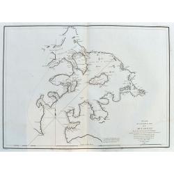
![[No title] Kamtschatskisches Meer.](/uploads/cache/21312-250x250.jpg)
[No title] Kamtschatskisches Meer.
Engraved by S. V.Dorn. Early map of Alaska.
Date: Germany 1790
Selling price: ????
Please login to see price!
Sold

A Chart of the Interior part of North America demonstrating the very great possibility of an Island of Navigation from Hudson's Bay to the West Coast
Rare and curious map of a supposed "Northwest Passage" from the Hudson Bay into the Pacific Ocean. Based upon the explorations of John Meares in 1788 and 1789....
Date: London, 1790
Selling price: ????
Please login to see price!
Sold in 2009

Canada, Louisiane, États-Unis.
Uncommon third state with changed title cartouche and corrigés par le Cen.Lamarche son successeur added to title.Two maps on one sheet. The map of the western part of No...
Date: Paris, 1790
Selling price: ????
Please login to see price!
Sold in 2010
Nouveau Mexique, Louisiane, Canada. . .
Map showing United States and Canada. Left and right a box with geographical information for each part country on the continent.Prepared by Louis Brion de la Tour and pub...
Date: Paris, 1790
Selling price: ????
Please login to see price!
Sold in 2016

La destruction de la Statue royale a Nouvelle York.
One of the few European prints dealing with the Revolutionary war.J. Chereau was a publisher of optical prints, established in Paris, rue St.Jacques. In the eighteenth an...
Date: Paris, 1790
Selling price: ????
Please login to see price!
Sold in 2012

A New & Accurate Map of North America: With the New Discovered Islands on the North East coast of Asia
This fine map focuses on the discoveries of Captain Cook in the Pacific Northwest and Alaska. Alaska is fairly well formed but misshapen, although much of the Aleutian Is...
Date: London, 1790
Selling price: ????
Please login to see price!
Sold in 2016
![[de Lafayette, full-length portrait] Conclusion de la campagne -- de 1781 en Virginie Liberté : To his Excellency General Washington this Likeness of his friend, the Marquess de la Fayette, is humbly dedicated, By le Mire. . .](/uploads/cache/36866-250x250.jpg)
[de Lafayette, full-length portrait] Conclusion de la campagne -- de 1781 en Virginie Liberté : To his Excellency General Washington this Likeness of his friend, the Marquess de la Fayette, is humbly dedicated, By le Mire. . .
Print shows Marquis de Lafayette, full-length portrait, standing, facing front, wearing a uniform, and holding two swords in the left hand while directing American troops...
Date: Paris, 1780 - 1790
Selling price: ????
Please login to see price!
Sold in 2016
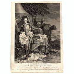
Le Général Washington ne quid detrimenti capiat res publica - gravé d'après le tableau original appartenant a Mr. Marquis de la Fayette. . .
Print shows George Washington, full-length portrait, standing outside tent, wearing military uniform, holding the Declaration of Independence and the treaty of alliance w...
Date: Paris, 1780 - 1790
Selling price: ????
Please login to see price!
Sold in 2016

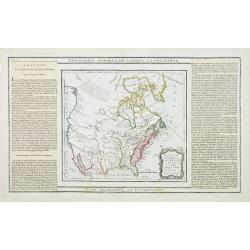
Amerique Septentrionale. . .
An interesting, and important map by the French cartographer, Robert de Vaugondy. A map of the United States beginning in the High Arctic and Baffin Bay, and then southwa...
Date: Paris, ca 1790
Selling price: ????
Please login to see price!
Sold in 2018

Amerique Septentrionale.
A large and scarce map of North America, including the recently discovered Sandwich Islands. With unusual areas, including a huge New Mexico and Louisian. Also a large pa...
Date: Augsburg, ca 1790
Selling price: ????
Please login to see price!
Sold in 2020
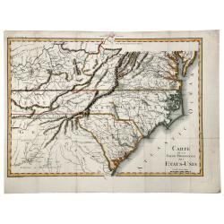
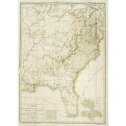
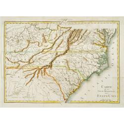
CARTE de la Partie Meridionale des ETATS-UNIS.
A nice example of this scarce and highly detailed map of the southern United States, showing excellent topography, roadways, and a great many place names and Indian tribe...
Date: Paris, 1790
Selling price: ????
Please login to see price!
Sold in 2019
Nouveau Mexique, Louisiane, Canada..
A lovely 1786 map of North America by Desnos and Brion de la Tour. It shows North America according to the French with a northwest passage extending west from Labrador an...
Date: Paris, 1790
Selling price: ????
Please login to see price!
Sold in 2020

A Man of Prince William's Sound / A Woman of Prince William's Sound.
A pair of copperplate engravings of a man and a woman from Prince William's Sound in Gulf of Alaska - taken rom drawings by John Webber from John Hawkesworth's account of...
Date: London, ca 1790
Selling price: ????
Please login to see price!
Sold in 2023

Chart of the North West Coast of America Explored by the Bousole & Astrolabe in 1786. (2nd Sheet)
A fine copperplate chart of the northwest coast of America from Mount La Touche to Cape Redondo. From La Perouse’s ATLAS DU VOYAGE DE LA PEROUSE. Published by G.G &...
Date: London, 1791
Selling price: ????
Please login to see price!
Sold in 2018

Amerique Septentrionale..
Richly embellished map of North America. Based on the Sanson map, which was the first to include all five Great Lakes. California now attached to the mainland. With a lar...
Date: Amsterdam 1792
Selling price: ????
Please login to see price!
Sold

Province de New-York en 4 Feuilles par Montresor.
The Le Rouge edition of the most important map of New York Province in the Revolutionary War period. Spectacular map in four sheets of New York. The map shows the adminis...
Date: Paris, 1777-1792
Selling price: ????
Please login to see price!
Sold in 2009

New York and Pensilvania.
Uncommon miniature map from Gibson's "Atlas Minimus, or a New Set of Pocket Maps of the several Empires, Kingdoms and States of the known World".
Date: London, 1792
Selling price: ????
Please login to see price!
Sold in 2011
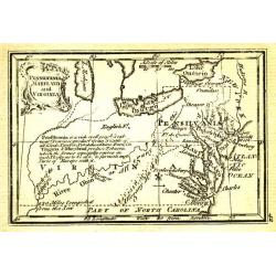
Pensilvania, Maryland and Virginia.
Uncommon miniature map from Gibson's "Atlas Minimus, or a New Set of Pocket Maps of the several Empires, Kingdoms and States of the known World".
Date: London, 1792
Selling price: ????
Please login to see price!
Sold in 2011
Carolina and Georgia.
Uncommon miniature map from Gibson's "Atlas Minimus, or a New Set of Pocket Maps of the several Empires, Kingdoms and States of the known World".
Date: London, 1792
Selling price: ????
Please login to see price!
Sold in 2011

New England.
Uncommon miniature map from Gibson's "Atlas Minimus, or a New Set of Pocket Maps of the several Empires, Kingdoms and States of the known World".
Date: London, 1792
Selling price: ????
Please login to see price!
Sold in 2011

North America.
Uncommon miniature map from Gibson's "Atlas Minimus, or a New Set of Pocket Maps of the several Empires, Kingdoms and States of the known World".
Date: London, 1792
Selling price: ????
Please login to see price!
Sold in 2011

A New and Accurate Map of North America from the best Authorities.
A scarce map of North America, from Brown's 'General Atlas', engraved by Menzies. It shows a 'River of the West', extending from the Juan De Fuca entrance to the R. Orega...
Date: Edinburgh, 1792
Selling price: ????
Please login to see price!
Sold in 2020

North America.
Uncommon miniature map from Gibson's "Atlas Minimus, or a New Set of Pocket Maps of the several Empires, Kingdoms and States of the known World". Together with ...
Date: London, 1792
Selling price: ????
Please login to see price!
Sold in 2017

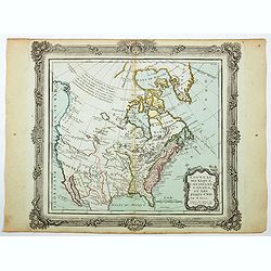
Amerique Septentrionale . . .
Richly embellished map of North America. Based on the Sanson map, which was the first to include all five Great Lakes. California now attached to the mainland. With a lar...
Date: Amsterdam, 1792
Selling price: ????
Please login to see price!
Sold in 2020

Western Part of the Territories.
A Map of the western part of the territories belonging to the United States of America. Engraved for Imlay's Topographical Description of that Country . Engraved by T. Co...
Date: London 1793
Selling price: ????
Please login to see price!
Sold
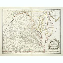
Carte De La Virginie Et Du Maryland Dressee sur la grande carte Angloise de Mrs. Josue Fry et Pierre Jefferson . . . 1755
A state five (of 5). Showing pre-revolutionary war Virginia and Maryland, extending west to the Alleghany Mountains, and including Delaware and a portion of New Jersey, ...
Date: Paris, ca.1793
Selling price: ????
Please login to see price!
Sold in 2013

RUSSIAN TEXT MAP - NORTH AMERICA.
A rare Russian, copper engraved map of north America. Based on the second state of the Janvier/Lattre map. It includes the results of Captain Cooks discoveries on America...
Date: St.Petersburg, 1793
Selling price: ????
Please login to see price!
Sold in 2021

Nouvelle Espagne, Nouvaeu Mexique, Isles Antiles.
Published by Charles Lamarche. Showing the most notable areas of New Spain in North, South and Central America from Nouveau Mexique to Terre Ferme as well as the Caribbea...
Date: Paris, 1794
Selling price: ????
Please login to see price!
Sold in 2011

A new and correct map of the British Colonies in North America. . .
Famous map prepared by Gov. Pownall Major Holland. Northern British Colonies, Quebec, New Foundland, Nova Scotia, New England, New York. Including Hudson and James Bays, ...
Date: London, 1794
Selling price: ????
Please login to see price!
Sold in 2013

A new map of North America agreeable to the most approved maps and charts. . .
Detailed and uncommon map of North America with the Northwest labeled These Parts Are Entirely Unknown and Land discovered by de L'Isle 1741. Engraved by T.Condor and pub...
Date: London, 1794
Selling price: ????
Please login to see price!
Sold in 2013
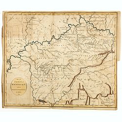
Map of the State of Kentucky with the Adjoining Territory By J. Russell 1794.
Important early map of Kentucky, showing primarily the region around the Ohio and Tennessee Rivers, from northern Georgia to Western Territory. Prepared by John Russell (...
Date: London, H.D. Symonds, 1794
Selling price: ????
Please login to see price!
Sold

Plan of the city of Philadelphia.
Rare plan of Philadelphia with a lettered key to the important buildings (A. Congress Hall, B. State House C. City Hall, (. . .) W. Bank U.S. X. Bank Penn. Y. Bank N.A., ...
Date: Philadelphia, 1794
Selling price: ????
Please login to see price!
Sold in 2015
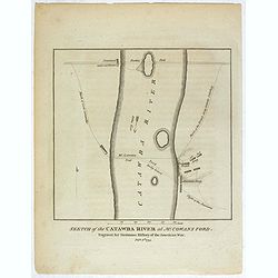
Sketch of the Catawba River at McCowan's Ford. . .
Revolutionary War battle plan, showing Lord Cornwallis' march and crossing of the Catawba River at McCown's Ford (now Cowan's Ford), and on towards Salisbury, along with ...
Date: London, 1794
Selling price: ????
Please login to see price!
Sold in 2018
Map of the Middle States of America, comprehends New-York, New-Jersey, Pennsylvania, Delaware, and the Territory N.W. of Ohio.
An interesting map of the region of the United States extending from New Jersey to Indiana, and from northern New York to Maryland. Detail in the east is plentiful, with ...
Date: London, 1794
Selling price: ????
Please login to see price!
Sold in 2017
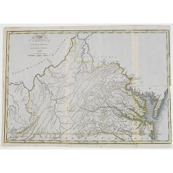
The State of Virginia from the best authorities, by Samuel Lewis. 1794.
Very detailed map of Virginia, prepared by Samuel Lewis.Engraved by Smithier and included in Carey's American Edition of Gurthries Geography.Underneath the map "engr...
Date: Philadelphia, Mathew Carey, 1795
Selling price: ????
Please login to see price!
Sold
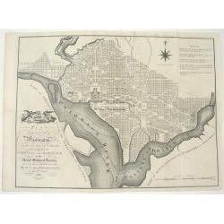
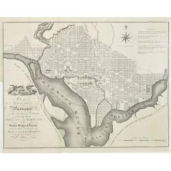
PLAN OF THE CITY OF WASHINGTON, IN THE TERRITORY OF COLUMBIA...
An important and very rare, state one example of the first British printing of Washington D.C. The plan derives from John Reid's, The American Atlas. The source for both...
Date: London, 1795
Selling price: ????
Please login to see price!
Sold

Canada, Louisiane, États-Unis. Par Robert de Vaugondy Géographé, Corrigés par le C.en Lamarche son Successeur. L'An 3.em de la République Franc?.
Two maps on one sheet. The map of the western part of North America is most notable for it's depiction of "Mer de L'Ouest" or "Sea of the West".A grea...
Date: Paris, 1795
Selling price: ????
Please login to see price!
Sold in 2016

Carte de la Partie de l'Amerique Septentrionale, comprenant les Possessions Anglaises.
Louis Brion de la Tour (1756-1823), French geographer. ' Atlas Géneral, Civil et Ecclésiastique', 1766, ' Atlas Général', 1790-98. From Brunet's 'Histoire Universelle...
Date: Paris, c. 1795
Selling price: ????
Please login to see price!
Sold
PLAN of the CITY of Washington, in the Territory of Columbia, ceded by the States of VIRGINIA AND MARYLAND to the United States of America, and by them established as the SEAT of their GOVERNMENT, after the YEAR 1800.
The famous 18th century plan of the Capital of Washington. This is the English issue of the official Thackara and Vallance plan, Philadelphia, 1792, which was made from L...
Date: London, 1795
Selling price: ????
Please login to see price!
Sold in 2009

Homme Masque de l'Isle de Sandwich
From a French edition of Captain Cook's voyages.
Date: Paris, ca. 1795
Selling price: ????
Please login to see price!
Sold in 2020

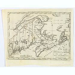
A Map of the District of Maine, Drawn from the Latest Surveys and Other Best Authorities.
A very lovely and important map. One of the first printed maps of Maine - At that time Maine was part of Massachusetts. The map was the frontispiece from James Sullivan�...
Date: Boston. 1795
Selling price: ????
Please login to see price!
Sold in 2017

Sauvage Iroquois.
Hand-colored mezzotints of Native Americans drawn by Labrousse and engraved by Laroque after Jacques Grasset de Saint-Sauveur.
Date: Paris,1796
Selling price: ????
Please login to see price!
Sold in 2011

Jongleur Iroquois.
Hand-colored mezzotints of Native Americans drawn by Labrousse and engraved by Laroque after Jacques Grasset de Saint-Sauveur.
Date: Paris,1796
Selling price: ????
Please login to see price!
Sold in 2011

New Hampshire entworfen von D.F. Sotzmann. Hamburg bey Carl Ernst Bohn 1796 . . . No. II.
Extremely rare map of New Hampshire prepared by Daniel Friedrich Sotzmann for Christopher Ebeling's "Erdbeschreibung von Amerika", a project ended after only te...
Date: Hamburg, Carl Ernst Bohn, 1796
Selling price: ????
Please login to see price!
Sold in 2016

Rhode-Island and Connecticut.
Published in Boston by Thomas and Andrews before the end of the eighteenth century, for the Rev J. Morse in his "The American Universal Geography". The map was ...
Date: Boston, 1796
Selling price: ????
Please login to see price!
Sold in 2018

Map of the State of New York.
Published in Boston by Thomas and Andrews before the end of the eighteenth century, for the Rev J. Morse in his "The American Universal Geography". The map show...
Date: Boston, 1796
Selling price: ????
Please login to see price!
Sold in 2016

Map of the District of maine with New Brunswick & Nova Scotia.
Published in Boston by Thomas and Andrews before the end of the eighteenth century, for the Rev J. Morse in his "The American Universal Geography".A map showing...
Date: Boston, 1796
Selling price: ????
Please login to see price!
Sold in 2016

A map of Massachusetts from the best Authorities by J.Denison.
The map highlights Martha's Vineyard and Nantucket Island. The "Proposed Canal" is located near Sandwich. Beneath the oval title cartouche and distance scale is...
Date: Boston, 1796
Selling price: ????
Please login to see price!
Sold in 2021

Map of the State of New York.
A nice post revolutionary war map of the state of New York by James Denison, published in Boston by Thomas and Andrews. Map shows rivers, mountains, roads, state boundari...
Date: Boston, 1796
Selling price: ????
Please login to see price!
Sold in 2019
Map of the District of Maine with New Brunswick & Nova Scotia.
Published in Boston by Thomas and Andrews before the end of the eighteenth century, for the Rev J. Morse in his "The American Universal Geography".A map showing...
Date: Boston, 1796
Selling price: ????
Please login to see price!
Sold in 2019

Plan du Port des Francais sur la Côte du Nord-Ouest de l' Amerique.
By Jean François Galoup, Comte de la Pérouse (1741-88), an outstanding French explorer and hydrographer. From Voyage autour du Monde?Atlas', 1797."Chart of the ent...
Date: Paris, 1797
Selling price: ????
Please login to see price!
Sold

Carte particulaiere de la Côte du Nord-Ouest de l\'Amerique, 1e Feuille.
Jean François Galoup, Comte de la Pérouse (1741-88), outstanding French explorer and hydrographer. Voyage autour du Monde?Atlas', 1797.A large chart from La Pérouse's ...
Date: Paris, 1797
Selling price: ????
Please login to see price!
Sold in 2009

Carte particulaire de la Côte du Nord-Ouest de l\'Amerique, 3e Feuille.
Jean François Galoup, Comte de la Pérouse (1741-88), outstanding French explorer and hydrographer. Voyage autour du Monde?Atlas', 1797.A large chart from La Pérouse's ...
Date: Paris, 1797
Selling price: ????
Please login to see price!
Sold in 2009

Carte particulaiere de la Côte du Nord-Ouest de l\'Amerique, 2e Feuille.
Jean François Galoup, Comte de la Pérouse (1741-88), outstanding French explorer and hydrographer. ' Voyage autour du Monde?Atlas', 1797.A large detailed chart from La ...
Date: Paris, 1797
Selling price: ????
Please login to see price!
Sold in 2009
![Plan du Port De St. Diego en Californie. . . 1782 [with] Plan Du Port et du Departement de San Blas . . . 1777.](/uploads/cache/34838-250x250.jpg)
Plan du Port De St. Diego en Californie. . . 1782 [with] Plan Du Port et du Departement de San Blas . . . 1777.
Two engraved maps on one page of the harbors of San Diego (ca. 1:100,000) in California and St. Blas (ca. 1:105,000) in Mexico . Depths by soundings. Engraved by L. Auber...
Date: Paris, 1797
Selling price: ????
Please login to see price!
Sold in 2014

Plan du Port De St. François Situé sur la côte de la CALIFORNIE Septentrionale . . . (San Francisco Bay)
The earliest obtainable printed map of San Francisco Bay, from the La Perouse's Voyages. Depths by soundings. Engraved by L. Aubert. The map includes 21 place names, incl...
Date: Paris, 1797
Selling price: ????
Please login to see price!
Sold in 2014

Carte particulaire de la Côte du Nord-Ouest de l'Amerique, 3e Feuille.
Jean François Galoup, Comte de la Pérouse (1741-88), outstanding French explorer and hydrographer. ' Voyage autour du Monde…Atlas', 1797.A large chart from La Pérous...
Date: Paris, 1797
Selling price: ????
Please login to see price!
Sold in 2016

Plan de l'Entrée du Port de Bucarelli sur la cote du Nord-Ouest de l'Amerique.
The Port Bucarelli is a harbour in Alaska, discovered in 1775 by two Spaniards, La Quadra & Maurelle, at Latitude 55N the furthest north that Spanish explorers got.Th...
Date: Paris, 1797
Selling price: ????
Please login to see price!
Sold in 2017

Carte Particuliere de la Cote du Nord-Ouest de l'Amerique reconnue par les Fregates Francaises la Boussole et l' Astrolabe en 1786 1e. Feuille.
Attractive chart of the Alaskan coast from Mount St.Elie south to Bay de ClonardThis chart was engraved by Bouclet for La Pérouse's 'Voyage autour du Monde'.Jean Francoi...
Date: Paris, 1797
Selling price: ????
Please login to see price!
Sold in 2018

Plan de l'Entree du Port de Bucarelli sur la Cote du Nord-Ouest de l'Amerique, par 55°15' de Latitude Nord et 136°15' de Longitude a l'Ouest de Paris . . .
Attractive chart of Bucareli Bay which is part of the Alexander Achipelago in the southeastern portion of AlaskaThis chart was engraved by Bouclet for La Pérouse's 'Voya...
Date: Paris, 1797
Selling price: ????
Please login to see price!
Sold in 2018

Carte Des Cotes De L'Amérique Et De L'Asie depuis la Californie jusqu'à Macao...1786 et 1787...
A large map showing La Perouse's expedition in the northern Pacific. Extends from Baja California to Alaska, and the east coast of Asia from Tartary to Canton, including ...
Date: Paris, 1797
Selling price: ????
Please login to see price!
Sold in 2017

Carte Particuliere de la Cote du Nord-Ouest de l'Amerique reconnue par les Fregates Francaises la Boussole et l' Astrolabe en 1786 1e. Feuille.
An attractive chart of the Alaskan coast from Mount St. Elie, south to Bay de Clonard.This chart was engraved by Bouclet for La Pérouse's 'Voyage autour du Monde'.Jean F...
Date: Paris, 1797
Selling price: ????
Please login to see price!
Sold in 2020

Partie de l'Amerique Septentrionale qui comprend Le Cours de l'Ohio, La Nlle Angleterre, la Nlle York, le New Jersey, La Pensylvanie, le Maryland La Virginie, La Caroline
A copperplate border colored map or the eastern United States, with inlet titled "Supplement pour la Caroline". First issued in 1755 ,here later state without d...
Date: Paris 1797
Selling price: ????
Please login to see price!
Sold in 2019

Partie de L'Amerique Septent. Qui comprend La Nouvelle France ou le Canada.
A decorative and highly detailed map of New England and part of Canada, extending east to Newfoundland, with a large inset map of the Great Lakes.One of the best large fo...
Date: Paris, 1797
Selling price: ????
Please login to see price!
Sold in 2019
Plan de l'Entree du Port de Bucarelli sur la Cote du Nord-Ouest de l'Amérique. . .
A large chart of Bucareli Bay which is part of the Alexander Archipelago in the southeastern portion of Alaska. Highly detailed with coasts, islands, small rocks, and dep...
Date: Paris, ca.1797
Selling price: ????
Please login to see price!
Sold in 2020

Plan du Port des Français sur la cote des Français ...
"Chart of the entrance of ""Bassin de L'Quest"", visited on July 2nd 1786 by La Perouse. On many 18th century maps we find a depiction of Mer de ...
Date: Paris 1798
Selling price: ????
Please login to see price!
Sold

Plan du Port des Français sur la cote du nord ouest. . .
Chart of the entrance of Bassin de L'Quest , visited on July 2nd 1786 by La Perouse. On many 18th century maps we find a depiction of Mer de L'Quest or Sea of the West a ...
Date: Paris, 1798
Selling price: ????
Please login to see price!
Sold in 2018

Maine entworfen von D.F. Sotzmann. Hamburg bey Carl Ernst Bohn 1798 . . . NO.VII
Extremely rare map of Maine prepared by Daniel Friedrich Sotzmann for Christopher Ebeling's "Erdbeschreibung von Amerika", a project ended after only ten maps o...
Date: Hamburg, Carl Ernst Bohn, 1798
Selling price: ????
Please login to see price!
Sold in 2016
Carte dés Carolines Méridionale et septrionale La Georgie, la Floride.. Le pays des Cherokées ..
Fine map of Florida, Carolinas and Georgia. From : Voyage dans les parties sud de l'Amérique septentrionale, savoir : les Carolines septentrionale et méridionale, la G�...
Date: Paris 1799
Selling price: ????
Please login to see price!
Sold

Rhode Island.
This small but striking map of Rhode Island is from Payne's Geography, published by John Low. Counties, roads, ponds, rivers, swamps, and towns and cities are shown. Unen...
Date: New York, 1799
Selling price: ????
Please login to see price!
Sold in 2017

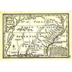
Carte des États-Unis, Provinces Méridionales.
The map shows portions of Kentucky, Virginia, Tennessee, Georgia, North Carolina, South Carolina, a strip of land between Tennessee and Georgia as 'United States Territor...
Date: Paris, 1799
Selling price: ????
Please login to see price!
Sold in 2022

Karte von .. Norstwestlichen Kuste America.
A very nice map centered on Northwest coast of America, including the city of Vancouver. On the lower left corner, an inset map (285x208 cm) of Japan, Taiwan and Chinese ...
Date: Berlin 1800
Selling price: ????
Please login to see price!
Sold

Part of the United States of North America.
Fine map of the eastern part of the United States, with in lower right an inset of South Carolina. An entirely new engraving, closely copied from the 1798 English edition...
Date: Berlin 1800
Selling price: ????
Please login to see price!
Sold
Carte de la partie méridionale des Etats-Unis.
Detailed map of North and South Carolina, Kentucky, Tennessee and Virginia. A separate publication of Pierre François Tardieu.With in lower left corner the address: Grav...
Date: Paris 1800
Selling price: ????
Please login to see price!
Sold

Karte von einem theil der Nord westlichen Küste von America..
A very nice map centered on Northwest coast of America, including the city of Vancouver. On the lower left corner, an inset map (285x208 cm) of Japan, Taiwan and Chinese ...
Date: Berlin 1800
Selling price: ????
Please login to see price!
Sold

Carte des cotes du Golfe du Mexique..
Detailed and important early chart of the Gulf Coast and Florida and dated 1800. From Neptune des cotes occidentales d'Amerique sur le Grand Ocean, an extensive atlas of ...
Date: Paris 1800
Selling price: ????
Please login to see price!
Sold

Philadelphia in Amerika. / Bonaparte an der spitze seiner Pariser National Garde am 8 Novemb. 1799
Copper engraving with four scenes on one sheet. In upper part a view of Philadelphia. Published in "Allgemeine Welt-Chronik oder neue und wichtige Zeit-Geschichte al...
Date: Zittau, 1798-1800
Selling price: ????
Please login to see price!
Sold

Il Canada le Colonie Inglesi con Luigiana e Florida . . .
Map of East coast of America including the Great Lakes. Fine title cartouche lower right hand corner. From Zatta's Atlante Novissimo.
Date: Venise, 1800
Selling price: ????
Please login to see price!
Sold in 2010

Theil der Vereinigten Staten von Nord America.
Detailed map of eastern part of the United States. In lower right hand corner inset map of Georgia, North and South Carolina.Showing routes of Mr. Weld.
Date: Germany, c.1800
Selling price: ????
Please login to see price!
Sold in 2012
