Browse Listings in America > North America
![[ Moose à Becky's Beach - Maine]](/uploads/cache/36364-250x250.jpg)
[ Moose à Becky's Beach - Maine]
A chart of part of Maine's coast line taken from the "Atlantic Neptune", and marked in lower right corner "Published according to Act of Parliament April 2...
Date: London, 1778
Selling price: ????
Please login to see price!
Sold in 2015
![[Kennebec or Sagadehoc River.]](/uploads/cache/36366-250x250.jpg)
[Kennebec or Sagadehoc River.]
A chart of Sagadahoc County taken from the "Atlantic Neptune", and marked in lower right corner "Published according to Act of Parliament April 24, 1776 by...
Date: London, 1778
Selling price: ????
Please login to see price!
Sold in 2016
![[Grand Manan Island (N.B.), Maine, New Brunswick.]](/uploads/cache/36367-250x250.jpg)
[Grand Manan Island (N.B.), Maine, New Brunswick.]
A chart of part Maine and New England taken from the "Atlantic Neptune", and marked in lower right corner "Surveyed & Published according to Act of Par...
Date: London, 1778
Selling price: ????
Please login to see price!
Sold in 2015
![[Mount Desert Island and neighboring coast of Maine. ]](/uploads/cache/36363-250x250.jpg)
[Mount Desert Island and neighboring coast of Maine. ]
This superb sea chart constructed for the use of the British Navy showschart of coast of Hancock County, with Mount Desert Island and neighboring coast of Maine, taken fr...
Date: London, 1778
Selling price: ????
Please login to see price!
Sold in 2015
![[Untitled chart of the Long Island Sound including Block Island]](/uploads/cache/39179-250x250.jpg)
[Untitled chart of the Long Island Sound including Block Island]
A chart of the end of Long Island and the area around Gardiner’s Bay. Including Gardners Island, and Block Island. Gardiner’s Island was used as a base by the British...
Date: London, 1778
Selling price: ????
Please login to see price!
Sold in 2017
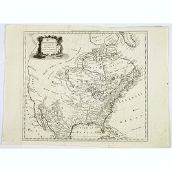
North America agreeable to the most approved maps and charts. . .
A detailed and uncommon map of North America with the Northwest labeled These Parts Are Entirely Unknown and the notations on the West Coast make various explorers' findi...
Date: London, 1778
Selling price: ????
Please login to see price!
Sold in 2017

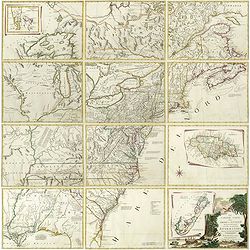
Le Colonie Unite dell´America.
Title: 'La Colonie Unite Dell' America Settentrle.' An impressive twelve-sheet map. This is Antonio Zatta's version of John Mitchell's landmark map, with some additional ...
Date: Italy, 1778
Selling price: ????
Please login to see price!
Sold in 2017

Representation du feu terrible à Nouvelle York.
So-called optical print of New York, showing several buildings along street engulfed in flames during fire on September 19, 1776, citizens being beaten by Redcoats, and l...
Date: Augsburg, 1778
Selling price: ????
Please login to see price!
Sold in 2019

Carte du Theatre de la Guerre actuel entre les Anglais et les Trieze Colonies Unies de l'Amerique Septentrionale dresse par J.B. Eliot
A fine example of J. B. Eliot's map of the United States, in its first state of which is generally regarded as the earliest map to include the title "United States''...
Date: Paris, 1778
Selling price: ????
Please login to see price!
Sold
Le Colonie Unite dell America Settentr.le di Nouva Projezione . . .
A complete set of 12 maps that when joined together form a large map of North America. Shows North America west to the Mississippi and Spanish-owned Louisiana, and north ...
Date: Venise, 1778
Selling price: ????
Please login to see price!
Sold in 2019

Le Colonie Unite dell America Settentr. le di Nouva Projezione . . .
A complete set of 12 maps that when joined together form a large map of North America. Shows North America west to the Mississippi and Spanish-owned Louisiana, and north ...
Date: Venise, 1778
Selling price: ????
Please login to see price!
Sold in 2019

La Baja D' HUDSON Terra Di Labrador e Groenlandia con Le Isole Adiacenti.
An excellent, old outlined colored map of Hudson Bay, Baffin Bay, part of Greenland, Labrador and Northern Canada. With marvellous detail on the islands and coastlines, k...
Date: Venice, 1778
Selling price: ????
Please login to see price!
Sold in 2020
![[Map of the interior of North America and New Spain] (sheet: No.2)](/uploads/cache/82993-250x250.jpg)
[Map of the interior of North America and New Spain] (sheet: No.2)
An engraved, old colored map showing roads, wooded areas, swamps, and settlements; areas of Native American habitation and the route of the Spanish Galleons. Includes not...
Date: Vienna, 1778
Selling price: ????
Please login to see price!
Sold in 2019
![[ Text page : Nautical directions to sail into the Harbour of New-York, & c.]](/uploads/cache/44836-250x250.jpg)
[ Text page : Nautical directions to sail into the Harbour of New-York, & c.]
Text page "Nautical directions to sail into the Harbour of New-York, & c.", taken from the "Atlantic Neptune". This superb sea chart constructed f...
Date: London, 1778
Selling price: ????
Please login to see price!
Sold in 2019

IL CANADA Le Colonie Inglesi Con La Luiglana e Florida. Di nuova Projezione.
A striking map of the United States and Canada, which includes references to the Upper and Lower English Colonies of Louisiana. One of the very few maps from the period w...
Date: Venice, 1778
Selling price: ????
Please login to see price!
Sold in 2020
![IL PAESE DE SELVAGGI OUTAGAMIANI, MASCOUTENSI, ILLINESI, E PARTE DELLE VI. NAZIONI. (Fogl. IV.)[Lake Michigan]](/uploads/cache/83526-250x250.jpg)
IL PAESE DE SELVAGGI OUTAGAMIANI, MASCOUTENSI, ILLINESI, E PARTE DELLE VI. NAZIONI. (Fogl. IV.)[Lake Michigan]
A striking and important regional map, bounded by the Missouri River, Lake Michigan and what would ultimately become Michigan in the north and extending south to include ...
Date: Venice, 1778
Selling price: ????
Please login to see price!
Sold in 2020

LA PARTE OCCIDENTALE DELLA NUOVA FRANCIA O CANADA (Fogl. II.)
A striking and detailed map of the region bounded by the Ottawa River and Hudson Bay, drawn from John Mitchell's seminal map. It shows Messesaguesi (Massachusetts) in sou...
Date: Venice, 1778
Selling price: ????
Please login to see price!
Sold in 2020
![IL PAESE DE SELVAGGI OUTAUACESI E KILISTINESI INTORNO AL LAGO SUPERIORE. (Fogl. I.)[LAKE SUPERIOR,FLORIDA&BAHAMAS]](/uploads/cache/83528-250x250.jpg)
IL PAESE DE SELVAGGI OUTAUACESI E KILISTINESI INTORNO AL LAGO SUPERIORE. (Fogl. I.)[LAKE SUPERIOR,FLORIDA&BAHAMAS]
A striking and detailed map of the region the Great Lakes and an inset showing Florida and Bahamas. This map is a part of the Italian edition of John Mitchell's map of th...
Date: Venice, 1778
Selling price: ????
Please login to see price!
Sold in 2020
![LA PENSILVANIA, LA NUOVA YORK, IL JERSEY SETTENTRIO:le, CON LA PARTE OCCIDENTALE DEL CONNECTICUT. . . (Fogl. V.)[Lakes Huron, Erie, and Ontario]](/uploads/cache/83531-250x250.jpg)
LA PENSILVANIA, LA NUOVA YORK, IL JERSEY SETTENTRIO:le, CON LA PARTE OCCIDENTALE DEL CONNECTICUT. . . (Fogl. V.)[Lakes Huron, Erie, and Ontario]
A striking map of the north eastern section of the Italian edition of Mitchell's seminal map of North America, bounded by Lakes Huron & Oswego and Ohio in the west an...
Date: Venice, 1778
Selling price: ????
Please login to see price!
Sold in 2020

Carte du Théatre de la Guerre Entre les Anglais et les Américains: Dressée d'apres les Cartes Anglaises les plus modernes
Uncommon 1778 edition with the site of Burgoyne's surrender at Saratoga (here spelled "Saharatoga").This is an important separately published French map of the ...
Date: Paris, Esnauts et Rapilly, 1778
Selling price: ????
Please login to see price!
Sold in 2021

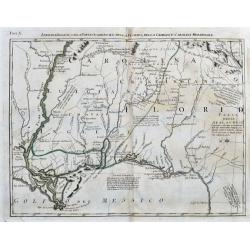
Fogl. VI. L' Acadia Le Provincie di Sagadahook e Main La Nuova Hampshire La Rhode Island e Parte Di Massachusset e Connecticut.
The 6th sheet from an important twelve-sheet map, of the south east Canada and north east United States of America. The 12 map Antonio Zatta's version of John Mitchell'...
Date: Venice, 1778
Selling price: ????
Please login to see price!
Sold in 2020
Luigiana Inglese, colla Parte Occidentale della Florida, della Giorgia, e Carolina Meridonale.
A very interesting Italian map based on John Mitchell's important map from 1755. It shows the Gulf Coast from Florida until the Mississippi Delta. It includes Biloxi, Pen...
Date: Venice, 1778
Selling price: ????
Please login to see price!
Sold in 2020
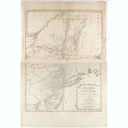
Mappa geographica Provinciæ Nova Eboraci ab Anglis New-York dictæ ex ampliori delineatione ad exactas dimensiones concinnata in arctius spatium redacta cura Claudii Josephi Sauthier ...
Mappa geographica Provinciæ Nova Eboraci ab Anglis New-York dictæ ex ampliori delineatione ad exactas dimensiones concinnata in arctius spatium redacta cura Claudii Jos...
Date: Nuremburg, 1778
Selling price: ????
Please login to see price!
Sold in 2020

Marché Désclaves Pl.XI. / Coton / Ventilateur et Mache.
Plates from the small edition of Diderot's Encyclopaedia. Engraved by Laurent. Very important work as it is giving an inventory of the science and craftsmanship of the 18...
Date: Paris 1779
Selling price: ????
Please login to see price!
Sold

Carte Générale des Découvertes de l'Amiral de Fonte representant la grande probabilité d'un Passage au Nord Ouest. . .
Robert de Vaugondy based this map of the northern Pacific and Alaska on a publication by Thomas Jefferys in London in 1768. Published in the supplement to Diderot’s &qu...
Date: Paris, 1779
Selling price: ????
Please login to see price!
Sold in 2013

Carte générale des découvertes de l'Admiral de Fonte ..
Based on the map of the northern Pacific, published by Jacques-Nicolas de l'Isle in Paris in 1752. Shows clearly the extraordinary network of channels supposed to link th...
Date: Paris 1779
Selling price: ????
Please login to see price!
Sold

Carte générale des découvertes de l'Admiral de Fonte ..
Based on the map of the northern Pacific, published by Jacques-Nicolas de l'Isle in Paris in 1752. Shows clearly the extraordinary network of channels supposed to link th...
Date: Paris 1779
Selling price: ????
Please login to see price!
Sold

Carte de la Californie et des Pays Nord-Ouest..4de Carte
Diderot's famous 2 on 1 map showing the two early mappings of the west coast of North America, the first after Visscher, the second after Plancius' World map. Both show t...
Date: Paris, 1779
Selling price: ????
Please login to see price!
Sold in 2013
A Chorographical Map of the Province of New-York in North America, Divided into Counties, Manors, Patents and Townships ... January 1st. 1779.
CLAUDE JOSEPH SAUTHIER’S SUPERB MAP OF THE PROVINCE OF NEW YORK IS A TOUR-DE-FORCE. Sauthier (1736-1802) was an engineer who accompanied Governor William Tryon to North...
Date: London, January 1st. 1779
Selling price: ????
Please login to see price!
Sold in 2013

Carte de la Californie suivant..
Five maps on one folding sheet, showing the development of the mapping of California. The map is from Diderot's "Encyclopedie" which contains ten maps o...
Date: Paris, 1779
Selling price: ????
Please login to see price!
Sold in 2009
![Carte Des Nouvelles Decouvertes dresseee par Phil. Buache... [with] Extrait d'une Carte Japonoise de l'Univers apportee en Europe par Kaempfer . . . [Bay of the West]](/uploads/cache/25609-250x250.jpg)
Carte Des Nouvelles Decouvertes dresseee par Phil. Buache... [with] Extrait d'une Carte Japonoise de l'Univers apportee en Europe par Kaempfer . . . [Bay of the West]
This map is most notable for it's depiction of "Mer de L'Ouest" or "Sea of the West", a great sea, easily the size of the Mediterranean, to flow from ...
Date: Paris, 1779
Selling price: ????
Please login to see price!
Sold in 2014

Carte Générale des Découvertes de l'Amiral de Fonte, et autres . . .
A map from Diderot's Encyclopédie which makes the case for a northwest passage. Included as part of the evidence is the route of Admiral De Fonte, a completely fictitiou...
Date: Paris, (1752) 1779
Selling price: ????
Please login to see price!
Sold in 2011

Carte générale des découvertes de l''Amiral de Fonte. . .
Based on the map of the northern Pacific, published by Jacques-Nicolas de l''Isle in Paris in 1752. It shows clearly the extraordinary network of channels supposed to lin...
Date: Paris, 1779
Selling price: ????
Please login to see price!
Sold in 2014

Carte de la Californie et des Pays Nord-Ouest ?
The map is from Diderot's Encyclopedie which contains ten maps of America, Asia and the Arctic Regions. This 2 on 1 map shows the two early mappings of the west coast of ...
Date: Paris, 1779
Selling price: ????
Please login to see price!
Sold in 2010
Carte de la Californie suivant . . .
Five maps on one folding sheet, showing the development of the mapping of California. The map is from Diderot's "Encyclopedie" which contains ten maps of Americ...
Date: Paris, 1779
Selling price: ????
Please login to see price!
Sold in 2009

Carte des Nouvelles découvertes ?
The map is from Diderot's 'Encyclopedia' which contains ten maps of Asia, America and the Arctic Regions. In both maps there are texts ago. by Kaempfer who refers to voya...
Date: Paris, 1779
Selling price: ????
Please login to see price!
Sold in 2009

Carte de la Californie et des Pays Nord-Ouest. . .
Diderot's famous 2 on 1 map showing the two early mappings of the west coast of North America, the first after Visscher, the second after Plancius' World map. Both show t...
Date: Paris, 1779
Selling price: ????
Please login to see price!
Sold in 2019

Carte de la côte N. O. de l\'Amérique et de la côte N. E. de l\'Asie reconnues en 1778 et 1779..
Map of the north Pacific with Alaska, engraved by Bernard.
Date: Paris, c. 1779
Selling price: ????
Please login to see price!
Sold in 2013

Carte de la Californie suivant. . . (Five maps on one sheet)
Five maps on one folding sheet, showing the development of the mapping of California. The map is from Diderot's Encyclopedie which contains ten maps of America, Asia and ...
Date: Paris, 1779
Selling price: ????
Please login to see price!
Sold in 2013

A chart of Delaware Bay and River : from the original by Mr. Fisher of Philadelphia 1776
Taken from the important chart of Delaware Bay and River up to Philadelphia by Joshua Fisher in 1776. Kashnor notes, "Shows the river from Cape James to Philadelphia...
Date: London, July 1779
Selling price: ????
Please login to see price!
Sold in 2021

Sir Walter Raleigh ordering the standard of Queen Elizabeth to be erected on the coast of Virginia.
A very decorative historical scene of Sir Walter Raleigh ordering the standard of Queen Elizabeth to be erected on the coast of Virginia in 1584, engraved by Taylor for '...
Date: London, 1779
Selling price: ????
Please login to see price!
Sold in 2015

Plan de la Baie et du Havre de Casco et des Iles Adjacents. . .
Sea chart of Casco Bay in Maine. Published in "Neptune Americo-Septentrional" at the time of the American Revolution. According to the title prepared by Antoine...
Date: Paris, ca.1779
Selling price: ????
Please login to see price!
Sold in 2018
![[Untitled chart of Portland and Falmouth in Maine]](/uploads/cache/39181-250x250.jpg)
[Untitled chart of Portland and Falmouth in Maine]
Fine chart of Portland and Falmouth in Maine, showing the homesteads, roads, and topography in the vicinity of Portland to the lower left corner. Taken from the "Atl...
Date: London, 1779
Selling price: ????
Please login to see price!
Sold in 2017
![[Untitled chart of Coast of Maine showing Blue Hill Bay, Penobscot Bay, Belfast Bay, Islesboro Island, Deer Island, and other islands]](/uploads/cache/39182-250x250.jpg)
[Untitled chart of Coast of Maine showing Blue Hill Bay, Penobscot Bay, Belfast Bay, Islesboro Island, Deer Island, and other islands]
Fine chart of coast of Maine showing Blue Hill Bay, Penobscot Bay, Belfast Bay, Islesboro Island, Deer Island, and other islands Taken from the "Atlantic Neptune&quo...
Date: London, 1779
Selling price: ????
Please login to see price!
Sold in 2017
![Carte Des Nouvelles Decouvertes dresseee par Phil. Buache... [with] Extrait d'une Carte Japonoise de l'Univers apportee en Europe par Kaempfer . . . [Bay of the West]](/uploads/cache/46319-250x250.jpg)
Carte Des Nouvelles Decouvertes dresseee par Phil. Buache... [with] Extrait d'une Carte Japonoise de l'Univers apportee en Europe par Kaempfer . . . [Bay of the West]
A very interesting pair of rare maps published as a single sheet in the 10 part series of maps created by Robert de Vaugondy in his 'supplement Receuil de 10 cartes trait...
Date: Paris, 1779
Selling price: ????
Please login to see price!
Sold in 2020

Les États Unis de L'Amerique Septentrionale..
Attractive map covering the Mississippi River and the Great Lakes and Texas region, prepared by R.Bonne and included in his "Atlas Ecyclopédique.."Ri...
Date: Paris 1780
Selling price: ????
Please login to see price!
Sold

Les États Unis de L''Amerique Septentrionale..
Attractive map covering North Americas east coast. Prepared by R.Bonne and included in his "Atlas Ecyclopédique.."Rigobert Bonne (1727-1795) was engi...
Date: Paris 1780
Selling price: ????
Please login to see price!
Sold

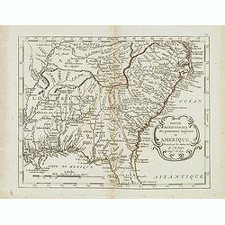
Carte Réduite Des Côtes Orientales De L' Amérique Septentrionale Contenant Celles des provinces de New-York et de la Nouvelle Angleterre..
A well engraved and highly detailed chart that was issued in Neptune americo-septentrionale. Showing the East Coast from Chaleur Bay to New Jersey, encompassing all of Ne...
Date: Paris, 1780
Selling price: ????
Please login to see price!
Sold in 2020

Partie du Nord de L'Amerique Septentrionale..
Rigobert Bonne (1727-1795), a prolific French cartographer, flourished between about 1760 and 1778, working in the French Hydrographical Office, and appointed as Hydrogra...
Date: Paris 1780
Selling price: ????
Please login to see price!
Sold

Karte von der Süd-See oder dem Stillen Meere..
The right hand sheet of a 2-sheet map of the Pacific. Depicting Mexico and California, most northern name is Punta de los Reyes, most southern is Acapulco, including Bay ...
Date: Paris, 1780
Selling price: ????
Please login to see price!
Sold in 2016
L'Ancien et le Nouveau Mexique avec la Floride et la Basse Louisiane. Partie Occidentale.
Excellent early map of California, Texas, Arizona, New Mexico, and Mexico. Very detailed with many towns, jesuit missions, forts, Indian areas, etc. Early geography of in...
Date: Paris, c 1780
Selling price: ????
Please login to see price!
Sold in 2010

Carte Nouvelle des Posséssions Angloises en Amérique. . .
Third state, of this rare and attractive map shows Eastern Canada and the American colonies. It is important as it gives a clear notion of the international intrigues and...
Date: Paris, Moithey et Crepy, 1780
Selling price: ????
Please login to see price!
Sold in 2018
Carte de la Louisiane et de la Floride
Interesting map of the Southeast and the Mississippi River Valley. The map extends from Charleston, South Carolina west to include New Orleans and north well into Illinoi...
Date: Paris, c1780
Selling price: ????
Please login to see price!
Sold in 2013

Pascaarte vande Noorder Zee Custen van America, vande West-Hoeck van Ysland doorde Straet Davis en Hudson, tot aen Terra Neuf
Fourth and last edition of van Keulen's chart of the Arctic Canada with the Hudson Bay and the supposed Northwest Passage. First published in 1680. The map is based upon ...
Date: Amsterdam, 1780
Selling price: ????
Please login to see price!
Sold in 2013

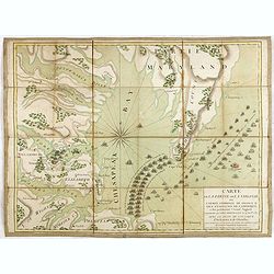
(Map showing the Albany-Oswego waterway)
Rare map of Upstate New York, showing the Albany-Oswego waterway. With Lake Oneida in the upper left part, showing towns as Sparte and Heurville, with land particions. &q...
Date: Paris, ca. 1780
Selling price: ????
Please login to see price!
Sold in 2015

Le Nouveau Mexique, Avec La Partie Septentrionale De L'Ancien, ou De La Nouvelle Espagne.
Highly detailed map of the Southwest USA, from Baja California to West Florida, including parts of Mexico and a tip of Yucatan. With very interesting features: In Texas,...
Date: Paris, 1780
Selling price: ????
Please login to see price!
Sold in 2015

America Settentrionale Secondo le scoperte fatte dal Cap. Cook.
Uncommon italian map of North America. Outlining the United States east of the Mississippi river. With a large New Mexico, Maha Nation, and extensive blank areas in the N...
Date: ca. 1780
Selling price: ????
Please login to see price!
Sold in 2015

Carte des nouvelles decouvertes au Nord de la Mer du Sud.
The Dezauche edition of Joseph De L'Isle map concentrating on the northern Pacific and showing all of North America and Mexico. While the Russian coastline is shown with ...
Date: Paris, Dezauche, 1780
Selling price: ????
Please login to see price!
Sold in 2023

Carte des Isles Antilles et du Golfe du Mexique, avec la Majeure partie de la Nouvelle Espagne. Par M. Bonne, Inge´nieur Hydrographe de la Marine. Aoust 1780. . .
The first edition of this scarce large format map of Florida, the Gulf Coast, Texas (almost to Corpus Christi), Mexico, Baja California and Central America, northern Sout...
Date: Paris, 1780
Selling price: ????
Please login to see price!
Sold in 2022
L'America settentrionale divisa ne' suoi principali stati.
Rare map of North America, from "Atlante Novissimo ad uso Dei Giovani Studiosi Contenuto In Carte XXVII.", published by Giovanni Zempel in Rome, ca. 1780.The ma...
Date: Rome, 1780
Selling price: ????
Please login to see price!
Sold in 2019
![Carte de la côte N[ord] O[uest]. de l'Amérique et de la côte N. E. de l'Asie reconnues en 1778 et 1779. . .](/uploads/cache/43766-250x250.jpg)
Carte de la côte N[ord] O[uest]. de l'Amérique et de la côte N. E. de l'Asie reconnues en 1778 et 1779. . .
A map of the north Pacific with Alaska, engraved by André. With inset map "Plan de l'Entrée de Nootka. . ." This is the general map of the northwest coast fro...
Date: Paris, ca 1780
Selling price: ????
Please login to see price!
Sold in 2020

Carta Della Florida, Luigiana e Laghi del Canada.
A scarce Italian map of the United States, Florida, Louisiana and Canada, probably issued during the American Revolutionary War. The eastern US is called 'Province Unite'...
Date: Venice, ca 1780
Selling price: ????
Please login to see price!
Sold in 2020

The coast, rivers and inlets of the Province of Georgia surveyed by Joseph Avery and others. . .
Chart of part of the Eastern Seaboard of the USA, with Port Royal Sound, the Savannah River, Warsaw Inlet (Wassaw Sound), Osebaw Inlet (Ossabaw Sound) and St Catherine's ...
Date: London, 1780
Selling price: ????
Please login to see price!
Sold in 2019

A chart of the coast of New York, New Jersey, Pensilvania, Maryland, Virginia, North Carolina, & c. . . .
A chart of A chart of the coast of New York, New Jersey, Pennsylvania, Maryland, Virginia, North Carolina, & c., taken from the "Atlantic Neptune", and mark...
Date: London, 1780
Selling price: ????
Please login to see price!
Sold in 2019

Il Paese de Selvaggi Outauacesi e Kilistinesi Intorno al Lago Superiore.
This is one sheet from Antonio Zatta's version of John Mitchell's epic map. The whole map was titled "Le Colonie Unite dell' America Settentrle" and was publish...
Date: Venice, 1780
Selling price: ????
Please login to see price!
Sold in 2020
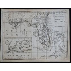
A Map of the New Governments of East & West Florida
Scarce early map of East & West Florida, shortly after the end of the French & Indian War.
Date: London, 1780
Selling price: ????
Please login to see price!
Sold in 2023

Carte de la partie de la Virginie ou l'armée combinée de France & des Etats-Nies de l'Amérique..
Extremely rare map of the lower Chesapeake Bay emphasizes the Revolutionary War naval battle that took place off the Virginia coast prior to General Charles Cornwalllis's...
Date: Paris, after 1781
Selling price: ????
Please login to see price!
Sold

Carte der Entdekungen Zwischen Sibirien und America bis auf das Jahr 1780
Very unusual map of Alaska and Kamchatka. Alaska is shown with only coastal detail according the reports of Capt. Cook. The Aleutian Islands stretch to within sight of th...
Date: Germany c.1781
Selling price: ????
Please login to see price!
Sold

A New and accurate Map of North America, Laid down according to the latest and most approved Observations..
Attractive map of North America showing the claims of the English, French and Spanish distinguished by early hand color. English bias is evident as the border reaches to ...
Date: London 1747 -1781
Selling price: ????
Please login to see price!
Sold

La Virginie, pennsilvanie, Nouvelle Angleterre. . .
Rare map including Virginia, Maryland and Pennsylvania. The map clearly delimits the British Colonies to the regions East of the Alleghany Mountains, based upon the Frenc...
Date: Paris, 1781
Selling price: ????
Please login to see price!
Sold in 2013
Partie méridionale des possessions Angloises en Amérique. . .
Scarce map of the East coast of North America, as far south as Louisiana and the northern half of Florida. Prepared by Nolin and published by L.J. Mondhare for his Atlas ...
Date: Paris, 1781
Selling price: ????
Please login to see price!
Sold in 2017

Plan De l'Isle d'Orléans ou Porto Condore. . .
Plan of New Orleans and it direct environs. From "Lettres Édifiantes et Curieuses. . Missionaires de la Compagnie de Jesus [Jesuit Letters]", 2nd Edition, Tome...
Date: Lyon, J. Vernarel and Et. Cabin et C., 1780/1781
Selling price: ????
Please login to see price!
Sold in 2019
Carte de la partie de la Virginie ou l'armée combinée de France & des Etats-Nies de l'Amérique..
Extremely rare map of the lower Chesapeake Bay emphasizes the Revolutionary War naval battle that took place off the Virginia coast prior to General Charles Cornwalllis's...
Date: Paris, after 1781
Selling price: ????
Please login to see price!
Sold in 2015
![[Untitled chart of Plymouth Bay]](/uploads/cache/39180-250x250.jpg)
[Untitled chart of Plymouth Bay]
Fine chart of Plymouth Bay in Massachusetts, showing the homesteads, roads, and topography in the vicinity of Plymouth. Taken from the "Atlantic Neptune", and m...
Date: London, 1781
Selling price: ????
Please login to see price!
Sold in 2017

Map of the Province of West Florida. By Tho.s Kitchin.
Scarce map of West Florida, from the May 1781 edition of the London Magazine. Includes a large detailed inset of Pensacola Harbor, including soundings and a not of the st...
Date: London, 1781
Selling price: ????
Please login to see price!
Sold in 2018

Cart de la Nouvelle Angleterre, Comprenant..
Complete title: ?Cart de la Nouvelle Angleterre, Comprenant les Etats de Massachusetts bay, N. Hamp Shire, Connecticut et Rhode Island?.An extremely scarce map of New Eng...
Date: Paris 1782
Selling price: ????
Please login to see price!
Sold

L'Amerique Septentrionale divisé en fes principaux.
A finely engraved map of North America, prepared by Janvier. The map is most notable for it's depiction of Mer de L'Quest or Sea of the West, a great sea, easily the size...
Date: Paris 1782
Selling price: ????
Please login to see price!
Sold

Amerique Septentrionale
Charming map of early North America including Central America and the West Indies. Filled with place names, Indian locations, and topographical information such as rivers...
Date: Paris 1782
Selling price: ????
Please login to see price!
Sold in 2008

Carte d\'une partie de l\'Amerique.. et de la Louisiane..
A handsome and seldom-seen map of the Spanish colonial period. Included in Voyages de Mr. de Pagés.De Pages, a French nobleman and Navy captain, crossed the \"Provi...
Date: Paris, 1782
Selling price: ????
Please login to see price!
Sold in 2008

Carte De La Louisiane Et Du Cours Du Mississipi Avec Les Colonies Anglaises. Revue, Corrigee et considerablemt. Augmentee en 1782 . . . Par Guillaume De L'Isle. . .
Unrecorded state of De L'Isle's seminal map, substantially updated with information on the British Colonies at the conclusion of the Revolutionary War.Accurate map showin...
Date: Paris, 1782
Selling price: ????
Please login to see price!
Sold in 2013
