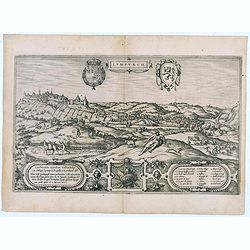
Lympurch. (Limburg)
Very desirable and early town-plan of the city of Limburg in Belgium with its fortifications at the end of the 16th century.From volume one of the greatest publication in...
- $250 / ≈ €216
Date: Cologne, 1575
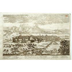
Namur.
A very RARE panoramic of the city of Namur, with a numbered legend in both lower corners.The plate is numbered in red pencil in upper right corner.Engraved by Pierre Avel...
- $150 / ≈ €130
Date: Paris, 1690-1720
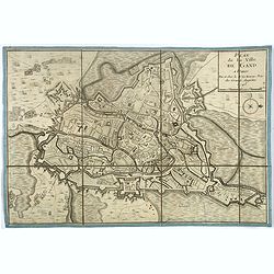
Plan de la ville de Gand. Paris, Sr. Le Rouge, 1745.
Town-plan of Ghent with its citadel, published in 1745, the year when the city was taken by the French during the War of Austrian Succession. The north is located to the ...
- $380 / ≈ €328
Date: Paris, 1745
![Plan de Mons ville capitale du comté de Haynaut. [MONS]](/uploads/cache/39799-250x250.jpg)
Plan de Mons ville capitale du comté de Haynaut. [MONS]
Charming little plan of the city of Mons in Belgium, engraved by Inselin, with a lettered key (A-V) in lower right corner.
Date: Paris, 1750
![La ville et citadelle d'Anvers. [Antwerp]](/uploads/cache/39843-250x250.jpg)
La ville et citadelle d'Anvers. [Antwerp]
A town-plan of the fortified enclosure of Antwerp with its citadel, showing the extensions made between 1201 and 1701, when the fortifications were enlarged by Philippe V...
- $225 / ≈ €194
Date: Paris, ca. 1750
![[OSTENDE] A new and exact Plan of the city and port of Ostend.](/uploads/cache/39849-250x250.jpg)
[OSTENDE] A new and exact Plan of the city and port of Ostend.
Nice plan of the city of Ostend and Fort Philippe, engraved by R. Benning. In upper left corner "A map of part of Flanders shewing the country and sands about Ostend...
- $300 / ≈ €259
Date: Paris, ca. 1750
