Browse Listings
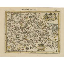
Palatinat. Bavariae.
Detailed map showing part of Bavaria. It covers the area between Ingolstadt, Nuremberg and Regensburg.From the first French-text edition of Jodocus Hondius' Atlas Minor.S...
- $50 / ≈ €43
Date: Amsterdam, 1608

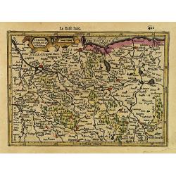
Saxoniae Superioris Lusatiae..
Detailed map of Saxony. With Prague at the bottom. From the first French-text edition of Jodocus Hondius' Atlas Minor.Shortly after the publication of the big folio-atlas...
- $50 / ≈ €43
Date: Amsterdam, 1608
Saxonia Inferior et Mekleburg.
Detailed map showing part of northern Germany. With major cities of the area named.From the first French-text edition of Jodocus Hondius' Atlas Minor.Shortly after the pu...
- $80 / ≈ €68
Date: Amsterdam, 1608

La Germanie.
Small map of Germany, including Austria and part of Poland. Strap work title cartouche in the lower left.From the first French-text edition of Jodocus Hondius' Atlas Mino...
- $75 / ≈ €64
Date: Amsterdam, 1608
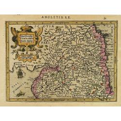
Northumbr. Cumberladia Dunelm. Episcop.
A map of the most northern part of England, from the first French-text edition of Jodocus Hondius' Atlas Minor.Shortly after the publication of the big folio-atlases the ...
- $100 / ≈ €85
Date: Amsterdam, 1608

Ultonia Oriental.
Map depicting part of Ulster, with the south-western tip of Scotland in the upper right. From the first French-text edition of Jodocus Hondius' Atlas Minor.Shortly after ...
- $75 / ≈ €64
Date: Amsterdam, 1608

Cuba Insula. Hispaniola.
Decorative engraved map of Cuba above Hispaniola with smaller insets of Havana, Jamaica, Puerto Rico and Margarita.From the first French-text edition of Jodocus Hondius''...
- $300 / ≈ €256
Date: Amsterdam, 1608

Anglia.
Map of England, from the first French-text edition of Jodocus Hondius'' Atlas Minor.Shortly after the publication of the big folio-atlases the need was apparently felt fo...
- $150 / ≈ €128
Date: Amsterdam, 1608
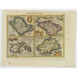
Anglesey Ins. / Wight.. / Ins. Garnesey. / Ins. Iarsey.
A reduced version of Mercator's folio map with four maps on one sheet depicting the English islands of Jersey, Guernsey, Wright and Alderney.Each map is embellished with ...
- $150 / ≈ €128
Date: Amsterdam, 1608

Das Wiflispurgergou.
Reduced version of Mercator''s map of the southwestern part of Switzerland. Shows Geneva, Lake Geneva, Lake Neuchatel, Lake Biel, Bern, Freiburg, Lake Thuner, etc.From th...
- $75 / ≈ €64
Date: Amsterdam, 1608
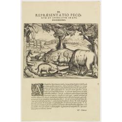
XI. Repraesentatio Pecorum et animalium in Guinea cicuratorum.
Various animals and birds from Africa. Engraved and published by Theodore de Bry, a German engraver and book dealer, began a compilation of early voyages in 1590 and had ...
- $100 / ≈ €85
Date: Frankfurt, 1609

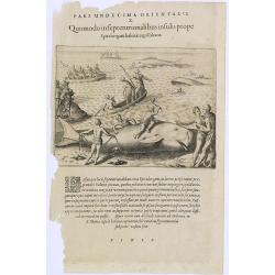
Pars Undecima Orientalis II. Quomodo Robertus, Caverta Capitaneus.
Fine engraving showing the arrest of the English captain Robert Caverta. Below an explanation in Latin that Caverta was arrested and killed by order of the king of the Co...
- $100 / ≈ €85
Date: Frankfurt, 1609
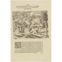
XIV. Repraesentatio Agriculturae et Fructuum Variorum exterra nafcentium.
Agriculture. Theodore de Bry, a German engraver and book dealer, began a compilation of early voyages in 1590 and had published six parts at the time of his death in 1598...
- $100 / ≈ €85
Date: Frankfurt, 1609
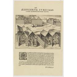
XV. Aedificiorum, et Rei Familiaris Administandae Ratio.
A village-scene in Guinea.Theodore de Bry, a German engraver and book dealer, began a compilation of early voyages in 1590 and had published six parts at the time of his ...
- $100 / ≈ €85
Date: Frankfurt, 1609
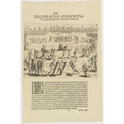
XVI. Delineatio Solennitatis, qua Nobiles Creari Solent.
Fine print of a Ceremony of electing or appointing a Nobleman in Guinea. Text below the engraving with an explanation in Latin : "During this ceremony there is a gre...
- $90 / ≈ €77
Date: Frankfurt, 1609
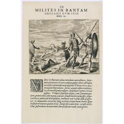
Milites in Bantam Gregarii Gum Suis armis. (Warriors of Bantam)
The warriors of Bantam carry both small and large shields made of leather, also swords or long lances with sturdy spear-heads. Their clothing is made with little square p...
- $75 / ≈ €64
Date: Frankfurt, 1609
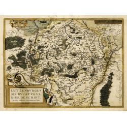
Lutzenburgensis Ducatus veriss descript.
Prepared by Jacob Surhon who made a manuscript map of Luxembourg for which he received 500 Livres from Charles V in 1551. For security reasons the map was not published. ...
Date: Antwerp, 1609

Solemnitas Nuptialis Bantam Incolarum. (A wedding ceremony in the city of Bantam)
When a young couple become engaged they do not leave their homes until the wedding takes place. On their wedding day they are dressed up and happy, and visited by all the...
- $75 / ≈ €64
Date: Frankfurt, 1609
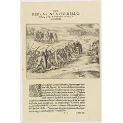
XXI. Repraesentatio Bellorum, Quae Aethiopes Invicem . . .
A fight between Ethiopian warriors.Theodore de Bry, a German engraver and book dealer, began a compilation of early voyages in 1590 and had published six parts at the tim...
- $75 / ≈ €64
Date: Frankfurt, 1609
![[Navigational chart].](/uploads/cache/37971-250x250.jpg)
[Navigational chart].
Two text engravings from "Premier livre de l'histoire de la navigation aux Indes Orientales, par les hollandois, et des choses a eux advenues . . . ", being the...
Date: Amsterdam, Cornille Nicolas, 1609
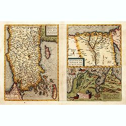
1) Natoliae,.. 2) Aegypti recentior.. 3) Carthaginis..
To the left a map of Turkey. Oriented with west at bottom. Right side of sheet contains a map of northern Egypt showing the Nile River delta, and a map the vicinity of Tu...
Date: Antwerp, 1570-1609
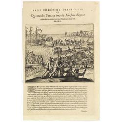
Pars Undecima Orientalis III. Quomodo Pembae incolae Anglos aliquot. . .
Finely engraved view of the arrival of Europeans at Pemba iIsland in Zanziba.Theodore de Bry, a German engraver and book dealer, began a compilation of early voyages in 1...
- $100 / ≈ €85
Date: Frankfurt, 1609

Tartaria.
A miniature map showing China, Korea and Russia. Title cartouche on the upper left corner.First published in 1598 in his Caert-Thresoor, the plates were executed by the m...
Date: Amsterdam, 1609
![[Titlepage] Nomenclator Ptolemaicus..](/uploads/cache/06436-250x250.jpg)
[Titlepage] Nomenclator Ptolemaicus..
Title page from a Ortelius Atlas part called: Nomenclator , containing a register of place names in antiquity. Letterpress with copper engraved print (60x60mm) of the eas...
- $150 / ≈ €128
Date: Antwerp, 1609
![Repraesentatio Aedificiorum in Benyn, et Quid Praeterea notatu dignum ibi occurrat. [Execution of criminals in Benin.]](/uploads/cache/29834-250x250.jpg)
Repraesentatio Aedificiorum in Benyn, et Quid Praeterea notatu dignum ibi occurrat. [Execution of criminals in Benin.]
Execution of criminals in Benin. According to the text: The town of Benin is quite large and comprises homes with no windows, only open roofs. The more distinguished hous...
- $100 / ≈ €85
Date: Frankfurt, 1609

Delineatio Piscationum Ternatensis.
Fishing scene on Ternate island, Maluku, Indonesia.Theodore de Bry, a German engraver and book dealer, began a compilation of early voyages in 1590 and had published six ...
- $80 / ≈ €68
Date: Frankfurt, 1609

Delineatio Civitatis et Castelli Amboinae.
Early view of Ambon, with 6 Dutch vessels offshore.Theodore de Bry, a German engraver and book dealer, began a compilation of early voyages in 1590 and had published six ...
Date: Frankfurt, 1609

Mercatorum Ex China in Bantam Negotiantium Schema.
An early portrait of Chinese merchants in Banten (Bantam), a small port town near Java's western end.Theodore de Bry, a German engraver and book dealer, began a compilati...
- $100 / ≈ €85
Date: Frankfurt, 1609

Turcicum Imperium / Empire Turc.
A miniature map of the Arabian peninsula, centered on Jerusalem. Title cartouche on the lower left corner.First published in 1598 in his Caert-Thresoor, the plates were e...
Date: Amsterdam/Frankfurt 1609
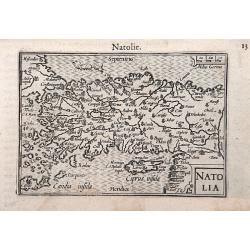
Natolia.
A miniature map of the Arabian peninsula, including Cyprus. The title cartouche on the lower right corner.First published in 1598 in his Caert-Thresoor, the plates were e...
- $200 / ≈ €171
Date: Amsterdam / Frankfurt, 1609

IX. Repraesentatio Piscationum Diurnarum.
Fishing offshore at the coasts of Guinea. Theodore de Bry, a German engraver and book dealer, began a compilation of early voyages in 1590 and had published six parts at ...
- $75 / ≈ €64
Date: Frankfurt, 1609
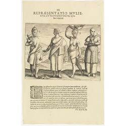
III. Repraesentatio Mullierum, et vestimentorum, Quibus Utuntur.
Inhabitants of the coast of the Ivory coast in Africa.Theodore de Bry, a German engraver and book dealer, began a compilation of early voyages in 1590 and had published s...
- $75 / ≈ €64
Date: Frankfurt, 1609
![[Description de la Figure de la ville de Gammelamme - Description du N° 15]](/uploads/cache/43504-250x250.jpg)
[Description de la Figure de la ville de Gammelamme - Description du N° 15]
View of the town of Gammelamme [Gamalama] on Ternate, where the Dutch established a trading post. Text engraving from "Premier livre de l'histoire de la navigation a...
- $50 / ≈ €43
Date: Amsterdam, Cornille Nicolas, 1609
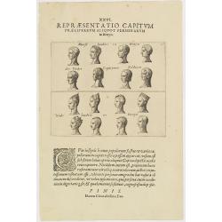
XXVI. Repraesentatio Capitum Praecipuarum Aliquot Personarum in Benyn.
Different types from Benin, in West Africa.Theodore de Bry, a German engraver and book dealer, began a compilation of early voyages in 1590 and had published six parts at...
- $75 / ≈ €64
Date: Frankfurt, 1609
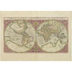
Orbis Terrae Compendiosa Descriptio.
Gerard Mercator's great world map of 1569 was condensed into double hemispherical form by his son Rumold. It first appeared in 1587 in Casaubon's edition of Strabo's Geog...
Date: Amsterdam, 1595-1609
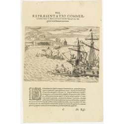
VIII. Repraesentatio Commerciorum et Negotiationum, Quas Nigritae cum Batauis exercent.
Locals from Gold Coast trying to sell items to the crew of a Dutch vessel. Theodore de Bry, a German engraver and book dealer, began a compilation of early voyages in 159...
- $100 / ≈ €85
Date: Frankfurt, 1609

V. Inusitata Terrae Concussio, in Insula S. Michael Facta.
Showing the Vila Franca earthquake on 26 July 1591Theodore de Bry, a German engraver and book dealer, began a compilation of early voyages in 1590 and had published six p...
- $75 / ≈ €64
Date: Frankfurt, 1609

XXVII. Triremes seu Galiottae et Fustae Iavenenfium. 21. ( A typical Javanese man-of-war ship)
A typical Javanese man-of-war ship. The Javanese call their man-of-war ships, Cathurs. The slaves are all seated below deck and do the rowing with oars, while the warrior...
- $150 / ≈ €128
Date: Frankfurt, 1609
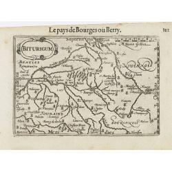
Biturigum.
A miniature map of the Berry. Fine cartouche in the upper left corner.First published in 1598 in his Caert-Thresoor, the plates were executed by the most famous engravers...
Date: Amsterdam/Frankfurt 1609

Germania.
A miniature map of Germany. The title cartouche on the lower left corner. First published in 1598 in his Caert-Thresoor, the plates were executed by the most famous engra...
- $75 / ≈ €64
Date: Amsterdam/Frankfurt, 1609

Leodiensis Dioecesis.
A miniature map of the southern part of Belgium centered on Liege. The title cartouche on the lower left corner.First published in 1598 in his Caert-Thresoor, the plates ...
- $75 / ≈ €64
Date: Amsterdam / Frankfurt, 1609
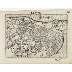
Die Zyp / La Zype.
A miniature map showing the polder of De Zype. Title cartouche in the upper side.First published in 1598 in his Caert-Thresoor, the plates were executed by the most famou...
Date: Amsterdam / Frankfurt, 1609

Coloniensis Diocesis.
A miniature map centered on Cologne. Title cartouche on the lower left corner.First published in 1598 in his Caert-Thresoor, the plates were executed by the most famous e...
- $80 / ≈ €68
Date: Amsterdam / Frankfurt, 1609

Hassiae Descriptio / Hesse.
A miniature map centered on the province of Hessen. The title cartouche on the upper right corner.First published in 1598 in his Caert-Thresoor, the plates were executed ...
- $50 / ≈ €43
Date: Amsterdam / Frankfurt, 1609

Noricum.
A miniature map showing a part of Bavaria, including the cities of Bamberg and Nuremberg. Title cartouche on the left side.First published in 1598 in his Caert-Thresoor, ...
- $50 / ≈ €43
Date: Amsterdam / Frankfurt, 1609
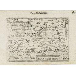
Sara et Zebenic.
A miniature map of the islands of Dalmatia. Title cartouche on the lower left side.First published in 1598 in his Caert-Thresoor, the plates were executed by the most fam...
- $100 / ≈ €85
Date: Amsterdam / Frankfurt, 1609
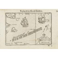
Maldivae Insulae.
Very fine early miniature map of Maldives Islands. East is at the top. Title cartouche on the lower right corner. A dolphin and two ships are depicted.First published in ...
Date: Amsterdam / Frankfurt, 1609

Mare Rubrum / Mer Rouge.
Wonderful miniature map includes the Red Sea, Yemen, and the east coast of the Arabian peninsula. One of the early maps to focus on this area. The title cartouche on the ...
Date: Amsterdam / Frankfurt, 1609

Mercatorum Extra. Neorum in Bantam Alia. Effigiatio. (People of Malacca)
People of Malacca.Theodore de Bry, a German engraver and book dealer, began a compilation of early voyages in 1590 and had published six parts at the time of his death in...
- $100 / ≈ €85
Date: Frankfurt, 1609

Habitus Moresque Insulae Sumatra Incolarum. (People of Sumatra)
People of Sumatra.Theodore de Bry, a German engraver and book dealer, began a compilation of early voyages in 1590 and had published six parts at the time of his death in...
- $100 / ≈ €85
Date: Frankfurt, 1609

XVI. Civitas Bantam Tormentis nostris oppugnata . . .
Attack of Bantam (Banten), a city and former sultanate on Java island.Theodore de Bry, a German engraver and book dealer, began a compilation of early voyages in 1590 and...
- $100 / ≈ €85
Date: Frankfurt, 1609

XXV. Quo Ritu Bantani Concilia Militaria Agant. 19. (Councils meeting at Bantam)
Councils meeting at Bantam (Banten), a city and former sultanate on Java island. Theodore de Bry, a German engraver and book dealer, began a compilation of early voyages ...
- $100 / ≈ €85
Date: Frankfurt, 1609
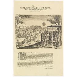
VII. Repraesentatio Processus in Iudiciis Civilibus et Criminalibus Ufitati. (Courts and Administration of Justice)
A depiction of the court and administration of justice. Seven features are identified : (A) the king or chief listening to a case presented to him, (B) the beheading of a...
- $90 / ≈ €77
Date: Frankfurt, 1609
![[Java Fruits].](/uploads/cache/37933-250x250.jpg)
[Java Fruits].
Text engraving of fruits on Java from "Premier livre de l'histoire de la navigation aux Indes Orientales, par les hollandois, et des choses a eux advenues . . . &qu...
- $75 / ≈ €64
Date: Amsterdam, Cornille Nicolas, 1609
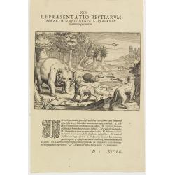
XIII. Repraesentatio Bestiarum ferarum Omnis Generis, quales in Guinea reperiuntur.
Fine engraving of Elephant and other wild animals. Theodore de Bry, a German engraver and book dealer, began a compilation of early voyages in 1590 and had published six ...
- $100 / ≈ €85
Date: Frankfurt, 1609

Natolia olim Asia Minor.
Genuine antique map "Natolia" by Abraham Ortelius from Epitome Theatri Orbis Terrarum, published in Antwerp in 1609. This charming 400-year-old miniature copper...
- $200 / ≈ €171
Date: Antwerp, 1609
![[Bantam].](/uploads/cache/37941-250x250.jpg)
[Bantam].
Text engraving showing the arrival of the Dutch fleet at Bantam from "Premier livre de l'histoire de la navigation aux Indes Orientales, par les hollandois, et des c...
- $150 / ≈ €128
Date: Amsterdam, Cornille Nicolas, 1609
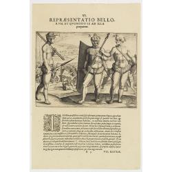
VI. Repraesentatio Bellorum, et Quomodo se ad Illa praeparent. (How the natives fight each other)
This shows how the men go to war and which weapons they use. They hold large square shields, about six feet high and four feet wide, made of cane and fortified with ox-hi...
- $90 / ≈ €77
Date: Frankfurt, 1609
II Pars Indiae Orientalis in qua Johan. Hugonis Linschotani. . .
De Bry's Part II of his "Les Petit Voyages", containing "Pars Indiae Orientalis, in qua Johan. Hugonis Linscotani navagatio in Orientem, 1609", being ...
Date: Frankfurt, Wolffgang Richter, 1609
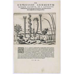
Expressio Germinum Quoque Aliorum, in S. Lavrentii.
Plants found in the island of S. Laurenti [Madagascar]. A’ denotes a tree with only a few twigs on the top. From this tree, canoes and boats are made. ‘B’ is a bush...
- $100 / ≈ €85
Date: Frankfurt, 1609
![[Plants and fruits of the East Indies].](/uploads/cache/37951-250x250.jpg)
[Plants and fruits of the East Indies].
Two text engravings from "Premier livre de l'histoire de la navigation aux Indes Orientales, par les hollandois, et des choses a eux advenues . . . ", being the...
- $50 / ≈ €43
Date: Amsterdam, Cornille Nicolas, 1609
Insula D.Helenae sacra coeli Clementia . . .
A fine perspective view of the Island of St.Helena in the South Atlantic. The location of the Island directly on the navigation route from Europe to the Cape of Good Hope...
- $750 / ≈ €641
Date: Frankfurt, 1609
Vera effigies et delineatio Infulce Ascenstio. . . (St. Helena)
Striking view of the Island of Ascuncion (St. Helena).Theodore de Bry, a German engraver and book dealer, began a compilation of early voyages in 1590 and had published s...
Date: Frankfurt, 1609
![[Ambon].](/uploads/cache/37953-250x250.jpg)
[Ambon].
Text engraving showing a bay on the Island of Ambon, an island in the Maluku Islands (Moluccas) of eastern Indonesia. Above the map a lettered key (A-D). Text engraving f...
- $150 / ≈ €128
Date: Amsterdam, Cornille Nicolas, 1609

Delineatio Foederis Hollandorum cum Rege Calecutanorum pacti.
A treaty between the Dutch and the king of Calicut. The Dutch Admiral, Steffan van der Haagen already knew that the people of Calicut, on the Malabar Coast of India, were...
- $100 / ≈ €85
Date: Frankfurt, 1609

Indianorum, Insulae Pugnatan Incolarum. (The natives of the island of Pugnatan)
There was an island called Pugnatan at the western entrance to the Strait of Sudan, where the natives went about completely naked. Like the natives of Brazil, their hair ...
- $100 / ≈ €85
Date: Frankfurt, 1609
Pars Undecima Orientalis X. Quomodo in Septentrionalibus insulis prope. (How the inhabitants catch whales off the east coast of Madagascar.)
How the inhabitants catch whales off the east coast of Madagascar. When the natives of Santa Marta, off the east coast of Madagascar see a whale, they row out in their li...
- $100 / ≈ €85
Date: Frankfurt, 1609
![[Bantam]](/uploads/cache/37939-250x250.jpg)
[Bantam]
Two text engravings from "Premier livre de l'histoire de la navigation aux Indes Orientales, par les hollandois, et des choses a eux advenues . . . ", being the...
- $100 / ≈ €85
Date: Amsterdam, Cornille Nicolas, 1609
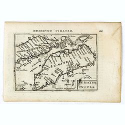
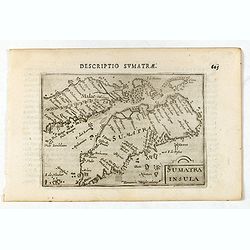
Sumatra Insula.
A miniature map of Sumatra and the Malay Peninsula, including Singapore and the various islands directly south of it. Containing detailed geography and nomenclature aroun...
Date: Amsterdam, 1609
![[Celebrating the arrival of the Dutch in Turban].](/uploads/cache/37949-250x250.jpg)
[Celebrating the arrival of the Dutch in Turban].
Text engravings of a tournament in Turban. On 23rd January 1599, the Dutch landed at Turban (on the north coast of Java) with several small boats. Great crowds of people ...
- $150 / ≈ €128
Date: Amsterdam, Cornille Nicolas, 1609
![[Dutch ship Amsterdam].](/uploads/cache/37948-250x250.jpg)
[Dutch ship Amsterdam].
Text engraving of the Dutch vessel Amsterdam offshore the island of Java near Surabaya from "Premier livre de l'histoire de la navigation aux Indes Orientales, par l...
- $150 / ≈ €128
Date: Amsterdam, Cornille Nicolas, 1609
![[Ternate].](/uploads/cache/37954-250x250.jpg)
[Ternate].
Text engraving showing a bay on the Island of Ternate, an island in the Maluku Islands (Moluccas) of eastern Indonesia. Above the map a lettered key (A-E). Text engraving...
- $100 / ≈ €85
Date: Amsterdam, Cornille Nicolas, 1609
![[Sumatra]](/uploads/cache/37955-250x250.jpg)
[Sumatra]
Text engraving from "Premier livre de l'histoire de la navigation aux Indes Orientales, par les hollandois, et des choses a eux advenues . . . ", being the clas...
- $50 / ≈ €43
Date: Amsterdam, Cornille Nicolas, 1609
![[Sunda].](/uploads/cache/37956-250x250.jpg)
[Sunda].
Text engraving and coastal profiles in wood block from "Premier livre de l'histoire de la navigation aux Indes Orientales, par les hollandois, et des choses a eux ad...
Date: Amsterdam, Cornille Nicolas, 1609
![[Javanese gamelan orchestra]](/uploads/cache/37960-250x250.jpg)
[Javanese gamelan orchestra]
Two text engravings from "Premier livre de l'histoire de la navigation aux Indes Orientales, par les hollandois, et des choses a eux advenues . . . ", being the...
- $75 / ≈ €64
Date: Amsterdam, Cornille Nicolas, 1609
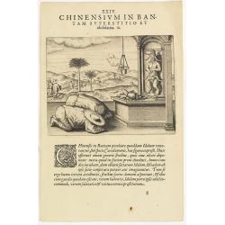
Chinensium in Bantam Superstitio et idololatria. 18. ( How the Chinese worship their idols in Bantam)
How the Chinese worship their idols in Bantam. As can be seen here, the Chinese worship their idol, which takes the form of a devil. They lay offerings of fruit on an alt...
- $100 / ≈ €85
Date: Frankfurt, 1609
![[Bantam].](/uploads/cache/37963-250x250.jpg)
[Bantam].
Text engraving showing some merchants of Bantam, from "Premier livre de l'histoire de la navigation aux Indes Orientales, par les hollandois, et des choses a eux adv...
- $75 / ≈ €64
Date: Amsterdam, Cornille Nicolas, 1609
Sumatra Insula.
A miniature map of Sumatra containing detailed geography and nomenclature around the entire island. The neighbouring coast of the Malay Peninsula is shown, including Sing...
- $450 / ≈ €385
Date: Amsterdam/Frankfurt 1609
![[Native Flora of Java].](/uploads/cache/37964-250x250.jpg)
[Native Flora of Java].
Text engraving of native flora of Java from "Premier livre de l'histoire de la navigation aux Indes Orientales, par les hollandois, et des choses a eux advenues . . ...
- $75 / ≈ €64
Date: Amsterdam, Cornille Nicolas, 1609
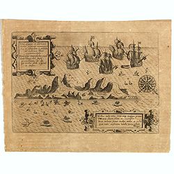
![[View of the arrival of Cornelis de Houtman's fleet at Bantam, Java.].](/uploads/cache/37937-250x250.jpg)
[View of the arrival of Cornelis de Houtman's fleet at Bantam, Java.].
Engraved map of Bantam on Java with a lettered key (A-N) showing the arrival of Cornelis de Houtman’s fleet at Bantam, Java in 1596. Houtman’s four vessels, the Amste...
- $200 / ≈ €171
Date: Amsterdam, Cornille Nicolas, 1609
