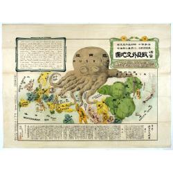
A Humorous Diplomatic Atlas of Europe and Asia. / 滑稽欧亜外交地図 / Kokkei Ō-A Gaikō Chizu.
A wonderful example of the rare 1904 Kisaburo Ohara satirical 'Octopus Map' of Europe being swallowed by an octopus (Russia). Composed at the outbreak of the Russo-Japane...
Date: Tokyo, April, 1904
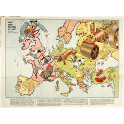
Hark ! Hark ! The dogs do bark.
This scarce political caricature map of Europe depicts the continent at the outbreak of World War I, or as it was called at the time, the Great War. Designed by Johnson, ...
Date: London, Johnson Riddle & Co.,1914
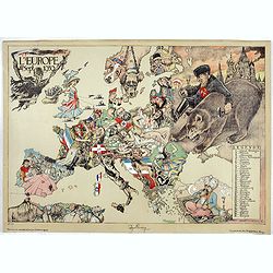
L'Europe en Sept 1939. Ille terrarum mihi angulus ridet.
A rare oversized serio-comic map of Europe at the start of the Second World War depicting stereotypes of 31 countries, as listed in the key lower right, including Brit...
Date: Bruges, Leon Burghgraeve, 1939
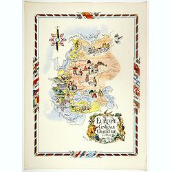
L'Europe Centrale et Orientale.
Pictorial tourism poster of central and eastern Europe, showing different life scenes relative to the culture's country.Learn more about pictorial maps. [+]
- $100 / ≈ €87
Date: Paris, 1951
