Browse Listings in Asia > South East Asia > Moluccas
![[Ternate].](/uploads/cache/37954-250x250.jpg)
[Ternate].
Text engraving showing a bay on the Island of Ternate, an island in the Maluku Islands (Moluccas) of eastern Indonesia. Above the map a lettered key (A-E). Text engraving...
- $100 / ≈ €86
Date: Amsterdam, Cornille Nicolas, 1609
![[Ambon].](/uploads/cache/37953-250x250.jpg)
[Ambon].
Text engraving showing a bay on the Island of Ambon, an island in the Maluku Islands (Moluccas) of eastern Indonesia. Above the map a lettered key (A-D). Text engraving f...
- $150 / ≈ €130
Date: Amsterdam, Cornille Nicolas, 1609

Delineatio Civitatis et Castelli Amboinae.
Early view of Ambon, with 6 Dutch vessels offshore.Theodore de Bry, a German engraver and book dealer, began a compilation of early voyages in 1590 and had published six ...
Date: Frankfurt, 1609
![[The Dutch reach Annabon.]](/uploads/cache/40075-250x250.jpg)
[The Dutch reach Annabon.]
Eight days after leaving the mainland, the Dutch arrived at one of the Annabon islands (Pagalu), where they asked the Portuguese and Moors, who were occupying the island,...
Date: Frankfurt, M.Merian, 1633

Moluccae Insulae Celeberrimae.
Showing the geographical features of the islands, and decorated with ships, sea monsters and a handsome cartouche. With an inset of Bachian island. From early on Willem ...
- $750 / ≈ €648
Date: Amsterdam, 1644

Moluccae Insulae Celeberrimae.
Showing the geographical features of the islands and decorated with ships, sea monsters and a handsome cartouche. With an inset of Bachian island. From early on Willem J...
- $750 / ≈ €648
Date: Amsterdam, ca.1645

Les Iles Molvcques, Celebes, Gilolo. . .
Map of the Indian Ocean Islands of the Moluccas Islands prepared by N.Sanson and published by Pierre Mariette.Published in an early edition of the small Sanson atlas L'Eu...
Date: Paris, P. Mariette, 1667
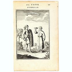
Molucquois (De L'Asie / figure LX).
A fine and uncommon early 17th century print of two people from Moluccas.From the French text edition of "Description d'Univers", 1683. by Allain Manneson Malle...
- $80 / ≈ €69
Date: Paris, 1683

Anabon. (Ambon)
A fanciful view of a landscape on the island Ambon. From the French reissue of the account of early Dutch voyages first published in 1608 by Commelin. The French transla...
- $120 / ≈ €104
Date: Amsterdam, E. Rogers, 1703

Le fort d'Amboine tel qu'il était en l'an 1607.
Fine plan of the Dutch fortress on Ambon Island which is part of the Maluku Islands of Indonesia. The island has an area of 775 km2 (299 sq mi).From the French reissue of...
- $75 / ≈ €65
Date: Amsterdam, J.F. Bernard, 1725

Le fort d'Amboine tel qu'il était en l'an 1607.
Fine depiction of the Dutch fortress on Ambon Island which is part of the Maluku Islands of Indonesia. The island has an area of 775 km2 (299 sq mi).From the French reiss...
- $80 / ≈ €69
Date: Amsterdam, J.F. Bernard, 1725

Ternate, par son aspect oriental.
This map is a view of Ternate with the summit of Gamalama from Dodoku Ali. From the French reissue of the account of early Dutch voyages first published in 1608 by Commel...
- $75 / ≈ €65
Date: Amsterdam, J.F. Bernard, 1725

Fort de l'Isle de Banda.
Decorative print of the Dutch VOC fortress on the island Banda. Until the mid-19th century the Banda Islands were the world's only source of the spices nutmeg and mace, p...
- $90 / ≈ €78
Date: Amsterdam, F. Bernard, 1725

Samboepo in platte Grond.
Decorative panoramic view of the town of Samboupo on the island of Celebes (Sulawesi) in today's Indonesia. Dutch (V.O.C.) sailing ships and various local craft fill the ...
- $150 / ≈ €130
Date: Amsterdam, 1726

Batsjan. (Bacan)
Decorative panoramic view of Bay with the Dutch fortress Barneveld at the island of Bacan in today's Indonesia. Dutch (V.O.C.) sailing ships are illustrated.François Val...
- $45 / ≈ €39
Date: Amsterdam, 1726

De Landvoogdy der Moluccos met de Aangrenzende Eylanden . . .
Two charts on one sheet depicting the Moluccas islands. Little interior detail is given but the coastlines, settlements and principal coastal features are identified. To ...
Date: Amsterdam, 1726
Insularum Moluccarum Nova description.
Exquisite map of the famous Spice Islands based. This map was the first large-scale map of the region and depicts the islands which provided first the Portuguese and then...
Date: Amsterdam, 1730
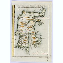
Carte de L'Isle Celebes ou Macassar.
A fine little copper engraved map of Celebes Island, Makassar.It is the provincial capital of South Sulawesi, Indonesia. It is the largest city on Sulawesi Island in term...
- $60 / ≈ €52
Date: Paris, 1754

Isles Moluques.
A scarce little map depicting European knowledge of Sulawesi, part of Borneo and the Spice Islands at the time of publication.George Louis Le Rouge was active from 1740- ...
Date: Paris, 1756

Carte Particuliere des Isles Moluques.
A very nice map centered on the island of the Moluccas.From Atlas Portatif pour servir a l'intelligence de l'Histoire Philosophique et Politique des etablissements et du ...
- $75 / ≈ €65
Date: Amsterdam, 1773

Carte Particuliere des Isles Moluques. . .
A very nice map centered on the island of the Moluccas.Title in French and in Dutch underneath the map.
Date: Amsterdam, 1773
![[ Island of Bouro with a view of Cayeli ].](/uploads/cache/25846-250x250.jpg)
[ Island of Bouro with a view of Cayeli ].
Aquatint depicts a view of Cayeli on the island of Bouro. Engraved by G.Castellini. Plate N° 55.From Giulio Ferrario's work Le Costume Ancien et Moderne ou Histoire du g...
- $50 / ≈ €43
Date: Milan, 1827
![[No title]. [Two locals of the island of Ubi ].](/uploads/cache/25845-250x250.jpg)
[No title]. [Two locals of the island of Ubi ].
Aquatint depicting two locals, one rowing to shore, the other searching for sea shells on the Island of Ubi in the Moluccas. Engraved by Carlo Bottigella. From Giulio Fer...
- $40 / ≈ €35
Date: Milan, 1827

Rade d'Amboine.
A peaceful lithograph of ships and boats at anchor in Ambon Island, located in the archipelago of the Moluccas in Indonesia. Plate 108 taken from the 'Voyage au Pole et d...
- $35 / ≈ €30
Date: Paris, 1842

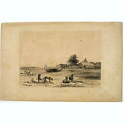
Riviere de Batou-Mera.
A lithograph of a simple bridge crossing the Batou-Mera river on the island of Ambone in the Moluccas, part of the Indonesian archipelago. Plate 110 taken from the 'Voyag...
- $100 / ≈ €86
Date: Paris, 1842
Rade de Ternate.
A peaceful harbour scene on the Moluccan island of Ternate in Eastern Indonesia. Plate 106 taken from the 'Voyage au Pole et dans L'Oceanie…' Departing in late 1837 in ...
- $50 / ≈ €43
Date: Paris, 1842

Kaart van't noordwestelijke gedeelte der Residentie Amboina . . . / Kaart der Molukken.
Two very detailed maps on one sheet, taken from "Atlas der Nederlandsche bezittingen in Oost-Indië", who was published by Departement van Koloniën".The m...
- $75 / ≈ €65
Date: The Hague, 1883-1885

Kaart van Celebes / Kaart van Zuid-West-Celebes : bevattende de Gouvernem.ts, de leenroerige en een gedeelte der bondgenootschappelijke landen behoorende tot het Gouvernement van Celebes en onderh.
Very detailed map taken from "Atlas der Nederlandsche bezittingen in Oost-Indië", who was published by Departement van Koloniën".First edition of one of ...
- $50 / ≈ €43
Date: The Hague, 1883-1885
