Browse Listings in Asia > South East Asia
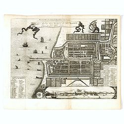
Waere affbeeldinge wegens het casteel ende stadt Batavia.
A good impression of Batavia's finely engraved and detailed plan, present-day Jakarta, the Dutch center of trading activities in the East Indies. Copied after Clement de ...
Date: Leiden, 1719

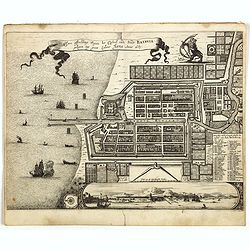
Ware affbeeldinge wegens het casteel ende stadt Batavia. . .
A reduced version of Clement de Jonghe (1650) plan of Jakarta from 1650. The town plan has a vignette at the bottom showing Jakarta from the sea with the volcanoes Mount ...
- $800 / ≈ €692
Date: Leiden, 1719
Waere affbeeldinge wegens het casteel ende stadt Batavia.
A good impression of this finely engraved and detailed plan of Batavia, present-day Jakarta, the Dutch center of trading activities in the East Indies. Copied after Cleme...
Date: Leiden, 1719

Plan de la Ville et du Chateau de Batavia en l'Isle de Java.
Detailed dual language plan of Batavia, the capital of the Dutch East Indies.Batavia, today’s Indonesian capital of Jakarta, was the center of Dutch economic activity i...
- $800 / ≈ €692
Date: Paris, 1719

La Rade de Batavia . . .
Beautifully engraved map with elaborate cartouche of present-day Jakarta. From van der Aa's very rare work "La galerie agreable du Monde".
- $300 / ≈ €259
Date: Leiden, 1719
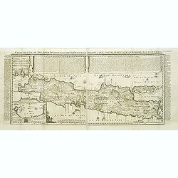
Carte de l'Ile de Java.
An inset plan of Batavia and clearly indicated rice fields, mountains, forests, towns in profile and even elephants suggest the wealth of detail found on this map. Modele...
Date: Amsterdam, 1720
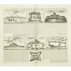
Vue et Description de Quelques-Uns des Principaux Forts des Hollandois dans les Indes .
Interesting sheet with seven detailed views illustrating the most important Dutch V.O.C. trading outposts and fortified colonial possessions in the East Indies, including...
Date: Amsterdam, 1720

Carte de l'Ile de Java. . .
An inset plan of Batavia clearly indicates rice fields, mountains, forests, towns in profile, and even elephants, suggesting the wealth of detail found on this map. Model...
Date: Amsterdam, 1720
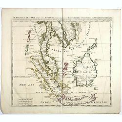
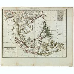
Le Royaume de Siam avec Les Royaumes Qui Luy sont Tributaries & c.
Influential map of Southeast Asia, including modern day Thailand, southern Vietnam, Cambodia, Malaysia, Singapore, Borneo, Sumatra and Java. Chatelain incorporated inform...
Date: Amsterdam, c.1720

Carte de l'Ile de Java: partie Occidentale, partie Orientale, Dressée tout nouvellement sur les Mémoirs les plus exacts, Avec une Table des principales villes de cette Ile. . .
One of the finest large-scale maps of Java, giving good information regarding the VOC settlements An inset plan of Batavia and clearly indicated rice fields, mountains, f...
- $1500 / ≈ €1297
Date: Amsterdam, 1720

Carte des Indes, de la Chine & des Isles de Sumatra, Java &c..
This fine and quite detailed general map extends from northern Japan to Timor and from India to New Guinea.There are very good details of towns and trade routes in modern...
Date: Amsterdam, 1720

Solor / A la Baye de Solor.
Decorative map of the Bay of Solor. With a lettered key (A - E). Solor is a volcanic island located off the eastern tip of Flores island in the Lesser Sunda Islands of In...
- $75 / ≈ €65
Date: Amsterdam, F. Bernard, 1725

La Baye de l'Isle & ville de Borneo.
Uncommon map of a Bay on the island of Borneo. From the French reissue of the account of early Dutch voyages first published in 1608 by Commelin. The French translation w...
- $75 / ≈ €65
Date: Amsterdam, F. Bernard, 1725

(Gunanappi / Wayer / Nera / Pulorin / Puloway .)
Uncommon map of islands in the Banda Sea. Several islands and villages are named, Wayer, Nera, Pulorin, Puloway, Lontoor, Ortattan and Combeer.From the French reissue of ...
- $75 / ≈ €65
Date: Amsterdam, F. Bernard, 1725

Fort de l'Isle de Banda.
Decorative print of the Dutch VOC fortress on the island Banda. Until the mid-19th century the Banda Islands were the world's only source of the spices nutmeg and mace, p...
- $90 / ≈ €78
Date: Amsterdam, F. Bernard, 1725

Ternate, par son aspect oriental.
This map is a view of Ternate with the summit of Gamalama from Dodoku Ali. From the French reissue of the account of early Dutch voyages first published in 1608 by Commel...
- $75 / ≈ €65
Date: Amsterdam, J.F. Bernard, 1725

Le fort d'Amboine tel qu'il était en l'an 1607.
Fine plan of the Dutch fortress on Ambon Island which is part of the Maluku Islands of Indonesia. The island has an area of 775 km2 (299 sq mi).From the French reissue of...
- $75 / ≈ €65
Date: Amsterdam, J.F. Bernard, 1725

Le fort d'Amboine tel qu'il était en l'an 1607.
Fine depiction of the Dutch fortress on Ambon Island which is part of the Maluku Islands of Indonesia. The island has an area of 775 km2 (299 sq mi).From the French reiss...
- $80 / ≈ €69
Date: Amsterdam, J.F. Bernard, 1725

La ville et le fort de Gamma-Lamma dans l'isle de Ternate lequel fort apartient aux Espagnols.
A view of the town and fortress on the island of Ternate. The city was in the southern part of the island, in the place now called Kastela. From the French reissue of the...
- $100 / ≈ €86
Date: Amsterdam, J.F. Bernard, 1725

(Bird's eye view of the Bay of Bantam)
Early view of the Bay of Bantam with the islands of Pulo dua and Batto.Bantam was always a product of the ferocious commercial rivalry between the Dutch and English and P...
- $75 / ≈ €65
Date: Amsterdam, F. Bernard, 1725

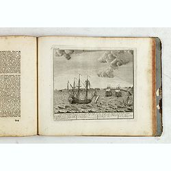
Batavia, L'an 1629.
Scarce town-view of Batavia (Jakarta) in 1629.From the French reissue of the account of early Dutch voyages first published in 1608 by Commelin. The French translation wa...
- $150 / ≈ €130
Date: Amsterdam, 1725
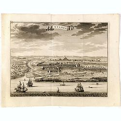
Astjien.
Nice bird's eye-view of the Town of Atjien on the northernmost point of Sumatra by François Valentijn (1666-1727), a missionary, who worked at Amboina from 1684 to 1694 ...
- $225 / ≈ €194
Date: Amsterdam, 1726

Makjan Geheel Bergagtig.
The island of Makian in Indonesia (formerly the Dutch East Indies) is represented on this map as a mountainous Möbius strip around a giant donut hole. François Valentij...
- $150 / ≈ €130
Date: Amsterdam, 1726
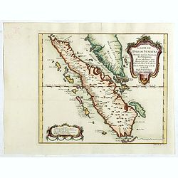
Nieuwe Kaart van het Eyland Sumatra..
Fine chart depicting the Island of Sumatra and the southern coasts of Malaysia from Quedo to Johore. North is orientated to the left of the page. Singapore is probably id...
Date: Amsterdam, 1726
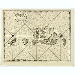
Nieuwe Caart der Eylanden van Banda.
Decorative map of the Banda Islands. Until the mid-19th century the Banda Islands were the world's only source of the spices nutmeg and mace, produced from the nutmeg tre...
Date: Amsterdam, 1726

Samboepo in platte Grond.
Decorative panoramic view of the town of Samboupo on the island of Celebes (Sulawesi) in today's Indonesia. Dutch (V.O.C.) sailing ships and various local craft fill the ...
- $150 / ≈ €130
Date: Amsterdam, 1726

Batsjan. (Bacan)
Decorative panoramic view of Bay with the Dutch fortress Barneveld at the island of Bacan in today's Indonesia. Dutch (V.O.C.) sailing ships are illustrated.François Val...
- $45 / ≈ €39
Date: Amsterdam, 1726

Samboepo in platte Grond.
Decorative panoramic view of the town of Samboupo on the island of Celebes (Sulawesi) in today's Indonesia. Dutch (V.O.C.) sailing ships and various local craft fill the ...
- $150 / ≈ €130
Date: Amsterdam, 1726

De Landvoogdy der Moluccos met de Aangrenzende Eylanden . . .
Two charts on one sheet depicting the Moluccas islands. Little interior detail is given but the coastlines, settlements and principal coastal features are identified. To ...
Date: Amsterdam, 1726

De Reede en stadt Batavia is geleegen aan de Noord Kust…
A chart of the bay of Batavia with in lower left corner a plan of Batavia (120x147mm). This very rare and influential chart gives a fine representation of Batavia, now kn...
Date: Amsterdam, 1728
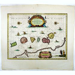
Insularum Moluccarum Nova description.
Exquisite map of the famous Spice Islands based. This map was the first large-scale map of the region and depicts the islands which provided first the Portuguese and then...
Date: Amsterdam, 1730

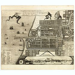
Plan de la Ville et du Chateau de Batavia en l'Isle de Iava / Ware affbeeldinge wegens het Casteel ende Stadt Batavia gelegen opt groot Eylant Java.
Detailed East oriented plan of Jakarta former Batavia on Java / Indonesia. With bird eye view from sea side, various ships and a lion. Two inset keys with detailed descri...
Date: Leiden, 1730
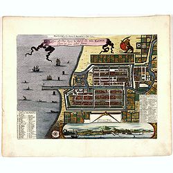
Plan de la Ville et du Chateau de Batavia en l'Isle de Iava / Ware affbeeldinge wegens het Casteel ende Stadt Batavia gelegen opt groot Eylant Java.
Detailed East-oriented plan of Jakarta former Batavia on Java / Indonesia. With a bird's eye view from seaside, various ships and a lion. Two inset keys with detailed des...
- $750 / ≈ €648
Date: Leiden, 1730
Plan de la Ville et du Chateau de Batavia en l'Isle de Iava / Ware affbeeldinge wegens het Casteel ende Stadt Batavia gelegen opt groot Eylant Java.
Detailed East-oriented plan of Jakarta former Batavia on Java / Indonesia. With bird's-eye view from sea side, various ships and a lion. Two inset keys with detailed desc...
Date: Leiden, 1730
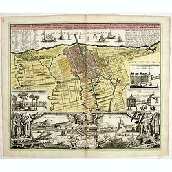
Der Hollaendisch-Ostindianischen Compagnie Weltberühmte Haupt - Handels und Niederlags stadt BATAVIA..
Very fine decorative plan of Batavia showing the City and its immediate environs, the surrounding rice fields intersected by a network of waterways, canals and outlying f...
Date: Nuremberg, 1733

Der Hollaendisch-Ostindianischen Compagnie Weltberühmte Haupt - Handels und Niederlags stadt BATAVIA..
A very fine decorative plan of Batavia showing the City and its immediate environs, the surrounding rice fields intersected by a network of waterways, canals and outlying...
Date: Nuremberg, 1733
Allerneuester geographisch- und topographischer Schau-Platz von Africa und Ost-Indien. . .
An early issue of this important book by Johann Wolfgang Heydt's describing the Dutch factories, settlements and stations at the hands of the Dutch East India Company in ...
Date: Wilhermsdorf, Tetscher u. Nürnberg, Homanns Erben, 1744

Carte des Isles de Java, Sumatra, Borneo. . . Malaca et Banca. . . / Kaart van de Eilanden van Java. . .
Dutch edition of this map of Indonesia prepared by N. Bellin and published by Pierre d'Hondt in Amsterdam. Jaques Nicolas Bellin (1703-1772) was one of the most important...
- $400 / ≈ €346
Date: Amsterdam, 1747

Les Isles de la Sonde Par le Sr. Robert de Vaugondy fils de Mr. Robert Geog. Ord du Roi avec Privilege 1749.
Small detailed map of of South East Asia, including Malaysian Peninsular with Singapore. From Atlas Portatif Universel, by Robert de Vaugondy.Page 170 outside border top...
Date: Paris, 1749
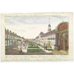
Die innere Aussicht des Castells in Batavia . . .
Showing the inside-square of the V.O.C. headquarters in Jakarta.The hand colored engraving is much perforated and the windows are cut out, a thin transparent paper is mou...
- $500 / ≈ €432
Date: Augsburg, 1750
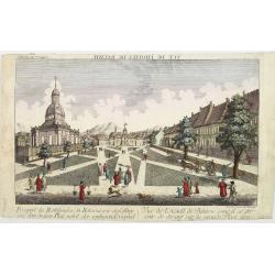
Vue de L'Hotel de Batavie. . .
A so-called optical print of Fatahillah Square in Jakarta, Indonesia, prepared for use in a light-box or an amusing light-show. This richly hand colored print is much per...
Date: Augsburg, 1750

Archipel des indes Orientales
A finely engraved map depicting South East Asia with very good detail on the Philippines. Decorative title cartouche. From Atlas Universel of Gilles and Didier Robert de ...
Date: Paris, 1750

Carte de L'Isle de Sumatra Dressee sur les Journaux des Navigateurs . . .
Detailed map of Sumatra and Malacca, centered on Singapore and including the southern portion of the Malaysian peninsula. With "Detroit de Sincapour" and severa...
Date: Paris, ca. 1750
Carte de L'Isle de Sumatra Dressee sur les Journaux des Navigateurs . . .
Detailed map of Sumatra and Malacca, centered on Singapore and including the southern portion of the Malaysian peninsula. With "Detroit de Sincapour" and severa...
Date: Paris, ca. 1750

The Philippine Islands and others of the East Indies. . .
Herman Moll's 'busy' map of South East Asia and the Philippines, published in the middle of the eighteenth century in London. The map includes numerous small islands, Sum...
- $280 / ≈ €242
Date: London, ca 1750
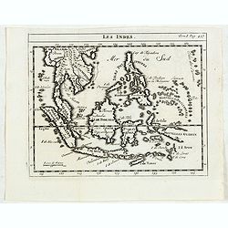
Les Indes.
Scarce small map of South East Asia with Indonesia, Thailand, Philippines and including New Guinee, based on cartography of Guillaume Delisle. Published in "Nouveau ...
- $125 / ≈ €108
Date: Paris, La veuve Lottin & Butard, P.G. Le Mercier, Rollin, 1751

Carte Des Isles de Java, Sumatra, Borneo.. Malaca et Banca..
Jacques Nicolas Bellin (1703-1772) was one of the most important and proficient French cartographers of the mid-eighteenth century. He was appointed the first Ingenieur H...
- $300 / ≈ €259
Date: Paris, 1752

Les Indes.
A scarce small map of Southeast Asia, including Indonesia, Thailand, the Philippines, and New Guinea, based on the cartography of Guillaume Delisle. Published in "No...
- $200 / ≈ €173
Date: Paris, ca. 1752

Carte de l'Isle de Sumatra. . . / Kaart van het Eiland Sumatra. . .
Map of Sumatra, also showing the tip of the Malay Peninsula and the Straits of Singapore. An unusually detailed map of the area, showing many coastal features, shoals, ba...
Date: The Hague, Pierre d'Hondt, 1753
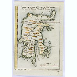
Carte de L'Isle Celebes ou Macassar.
A fine little copper engraved map of Celebes Island, Makassar.It is the provincial capital of South Sulawesi, Indonesia. It is the largest city on Sulawesi Island in term...
- $60 / ≈ €52
Date: Paris, 1754

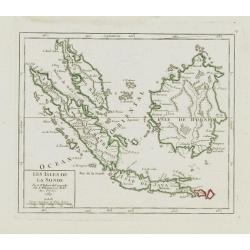
Isles de la Sonde.
Fine map of the islands of Java, Sumatra, Borneo, Bali and part of the Malay peninsular. George Louis Le Rouge was active from 1740- till 1780 as a publisher, and was app...
- $200 / ≈ €173
Date: Paris, 1756

Isles Moluques.
A scarce little map depicting European knowledge of Sulawesi, part of Borneo and the Spice Islands at the time of publication.George Louis Le Rouge was active from 1740- ...
Date: Paris, 1756

Belgium Foederatum auctius et emendatius edit..
Map of the northern part of the Netherlands. With a decorative title cartouche, with an inset map of South East Asia.
Date: Augsburg 1760

Les Isles de la Sonde, Moluques, Philippines, Carolines, et Marlannes.
Nice detailed map of southeast Asia, showing the Malay Peninsula, Sumatra, Java and the island of Borneo. Engraved by E. Dussy and the title cartouche by Arrivet. From hi...
- $275 / ≈ €238
Date: Paris, ca. 1762

Histoire universelle depuis le commmencement du monde jusqu'a present. Tome Vingt-unieme. Portugais, Espagnols, Hollanois etc
Volume 21 of this informative publication with a description of the discoveries, conquests, and settlements by the Portuguese, Spaniards, English, and Dutch in Southeast ...
- $1200 / ≈ €1037
Date: Amsterdam, Leipzig, 1763
Les Isles de la Sonde.
Small detailed map of southeast Asia, showing the Malay Peninsula, Sumatra, Java and the island of Borneo. Dated 1769.From Atlas Portatif Universel, by Robert de Vaugondy...
- $200 / ≈ €173
Date: Paris, later than 1769

Carte Particuliere des Isles Moluques.
A very nice map centered on the island of the Moluccas.From Atlas Portatif pour servir a l'intelligence de l'Histoire Philosophique et Politique des etablissements et du ...
- $75 / ≈ €65
Date: Amsterdam, 1773

Nouvelle carte de l'Isle de Java.
A very nice map centered on the island of Java. With French text in title cartouche and an additional title in Dutch underneath the map.Read more Early maps of South East...
Date: Amsterdam, 1773

Carte Particuliere des Isles Moluques. . .
A very nice map centered on the island of the Moluccas.Title in French and in Dutch underneath the map.
Date: Amsterdam, 1773

Les Indes Orientales et leur Archipel. . .
General map of Indonesia, extending from India to the Philippines and New Guinea.Ornated with a decorative title cartouche. Boundaries outlined in hand color.From theAtla...
- $250 / ≈ €216
Date: Paris, ca 1783

Plan der Stad en ‘t Kasteel BATAVIA. Aanwyzing der Stad en Kasteels Punten.
Very fine decorative plan of present-day Jakarta, showing the City and its immediate environs, the surrounding rice fields intersected by a network of waterways, canals a...
- $1750 / ≈ €1513
Date: Amsterdam, 1782-1783

Les Indes Orientales.. tirées du Neptune Oriental..
Finely and crisply engraved map centered on the Bay of Bengal, encompassing the Indian subcontinent and the Indochinese Peninsula.Venetian edition of Giles Didier Robert ...
- $450 / ≈ €389
Date: Venice, 1779 - 1784
![[Set of 4 maps] Indie Orientali di Quà e di la Dal Gange col Loro Arcipelago.](/uploads/cache/36680-250x250.jpg)
[Set of 4 maps] Indie Orientali di Quà e di la Dal Gange col Loro Arcipelago.
Fine almost wall sized map of South east Asia, including Formosa, New Guinea, the Maldives and the Indus delta. From his "Atlante Novissimo, illustrato ed accresciut...
- $850 / ≈ €735
Date: Venice, ca. 1779 - 1785
![Indie Orientali di Quà e di la Dal Gange col Loro Arcipelago. [Set of 4 maps]](/uploads/cache/43240-250x250.jpg)
Indie Orientali di Quà e di la Dal Gange col Loro Arcipelago. [Set of 4 maps]
Fine almost wall sized map of South east Asia, including Formosa, New Guinea, the Maldives and the Indus delta. From his "Atlante Novissimo, illustrato ed accresciut...
Date: Venice, ca. 1779 - 1785
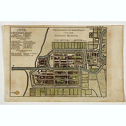
Grundriss von der Stadt und dem Schlosse Batavia.
Uncommon plan of the town and fortress of Batavia. The plan is based on the earlier, much larger map of Batavia published by Clement de Jonghe in 1650. From 'Algemeine We...
- $175 / ≈ €151
Date: Halle, 1763-1792

Le Indie Orientali E Il Loro Arcipelago . . .
Striking map of the region from the Gulf of Bengal to Hainan, centered on the Malay Peninsula, Straits of Malacca, Sumatra, Java and Philippines.This is the uncommon edit...
- $500 / ≈ €432
Date: Venise, 1794-1796

A new and Accurate map of the islands and Channels between China and New Holland.
Highly detailed map of Southeast Asia, covering the region between Formosa and Hainan islands in the North and Australia in the South.Including Burma to Taiwan with parts...
- $600 / ≈ €519
Date: Edinburgh, 1801

Les Indes Orientales et leur Archipel . . .
Map of India, the Maldive Islands, the Indonesian and Philippine Islands, from Atlas moderne portatif composé de vingt-huit cartes sur toutes les parties du globe terres...
- $300 / ≈ €259
Date: Paris, Prudhomme, Levrault, Debray, 1806
Presqu'Île au dela du Gange et Archipel de l'Inde.
Detailed map of Indonesia with Philippines and Taiwan. Engraved by P.F.Tardieu. From "Mentelle's Atlas Universe".
- $150 / ≈ €130
Date: Paris, ca 1784 / 1806
![View in the island of Cracatoa. [Rakata in the Sunda Strait]](/uploads/cache/30051-250x250.jpg)
View in the island of Cracatoa. [Rakata in the Sunda Strait]
Early view of the volcano Krakatoa (Indonesian name: Krakatau), on the Indonesian island of Rakata in the Sunda Strait, taken from "Views in the South Seas" bei...
Date: London, Boydell and Co., 1808
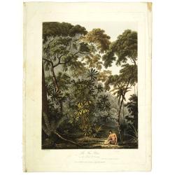
The Fan palm, in the island of Cracatoa.
The Fan palm, on the island of Krakatoa (Indonesian name: Krakatau), in the Sunda Strait, taken from "Views in the South Seas" being a very important and early ...
Date: London, Boydell and Co., 1808
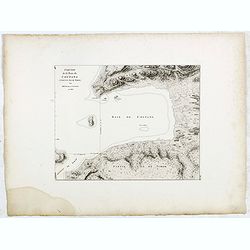
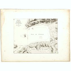
Esquisse de la Baie de Coupang (cote S.O. Ile de Timor) par M. M. Peron et Lesueur, an 1803.
Map of Kupang Bay on the Indonesian Island Timor, prepared by Louis Freycinet during his voyage under Captain Thomas Baudin in 1800-1803. Plate no. 14 from the atlas part...
- $100 / ≈ €86
Date: Paris, Langois, 1811
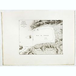
Esquisse de la Baie de Coupang (cote S.O. Ile de Timor) par M. M. Peron et Lesueur, an 1803.
Map of Kupang Bay on the Indonesian Island Timor, prepared by Louis Freycinet during his voyage under Captain Thomas Baudin in 1800-1803. Plate no. 14 from the atlas part...
- $150 / ≈ €130
Date: Paris, Langois, 1811
Esquisse de la Baie de Coupang (cote S.O. Ile de Timor) par M. M. Peron et Lesueur, an 1803.
Map of Kupang Bay on the Indonesian Island Timor, prepared by Louis Freycinet during his voyage under Captain Thomas Baudin in 1800-1803. Plate no. 14 from the atlas part...
Date: Paris, Langois, 1811
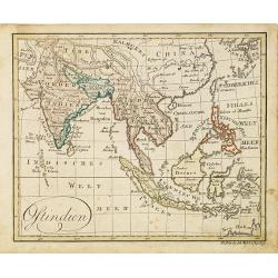
Ostindien.
Nice small map of South East Asia published by Johannes Walch in his rare Allgemeiner Atlas Nach den bewährsten Hülfsmitteln und astronomischen Ortsbestimungen…, edit...
- $160 / ≈ €138
Date: Augsburg, 1812
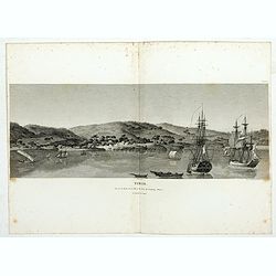
Timor. Vue de la rade, de la ville et du fort de Coupang, dans l'île de Timor.
Nice double page view of the town Kupang, formerly known as Koepang. In the center is the Dutch V.O.C. fort. From Voyage de découvertes aux terres Australes by François...
Date: Paris, 1807-1816
East India Isles.
Somewhat later but very finely engraved and detailed map of the Indonesian archipelago, including Thailand, Philippines and southern part of Taiwan.
Date: Edinburgh, 1817

Australien (Südland) auch Polynesien oder Inselwelt..
SECOND EDITION of the Johann Walch map of Australasia and the South Pacific. Australia lettered Neu Holland, the name given to it by Able Tasman that was still in use un...
Date: Augsburg, 1802-1820
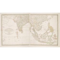
Charte von Ostindien Diesseits Und Jenseits Des Ganges / nach den neuesten astronomischen Beobachtungen auch andern sichern Hülfsmitteln neu entworfen. . .
Prepared by I.C.M.Reinecke giving good detail in India, Indonesia and the Philippines.
- $800 / ≈ €692
Date: Weimar, 1822
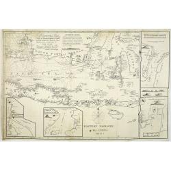
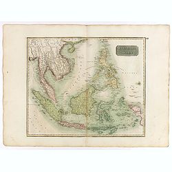
Eastern passage to China. sheet 1.
James Horsburgh early chart of the coasts of Java, Bali, Lombok, with part of Sulawesi, and Borneo. Insets of "Sketch of Bally Strait", Sketch of Lombock Strait...
- $2500 / ≈ €2161
Date: London, 1824
