Browse Listings
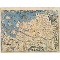
![CH'ONHA CHIDO [Atlas of all under Heaven]](/uploads/cache/33625-250x250.jpg)
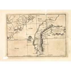
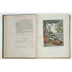
CH'ONHA CHIDO [Atlas of all under Heaven]
The Ch’onha chido [Atlas of all under Heaven] is a late 18th century copy of the traditional Korean atlas produced in the early Choson dynasty (1392-1910). One of the m...
Place & Date: Korea, ca. 1790
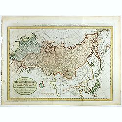
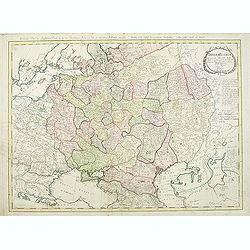
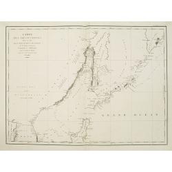
The Russian Empire in Europe and Asia . . .
Detailed map of the whole of Russia, extending from Poland to the Pacific and from Nova Zembla to Tartaria.The map is of interest for the use of Corea Gulf for the sea be...
Place & Date: London, 1790
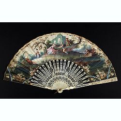
An elegant couple with a caged bird in a landscape.
Folding fan made of skin sheet and mounted in English style, with a painted scene of an elegant couple with a caged bird in a landscape.Painted verso of a man among ancie...
Place & Date: Paris, 1790
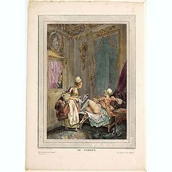
Le Curieux.
A risqué but delightful French engraving produced in the late eighteenth century. It is simply titled The Curious, and shows a young lady lying on her side on a divan, w...
Place & Date: Paris, ca. 1790
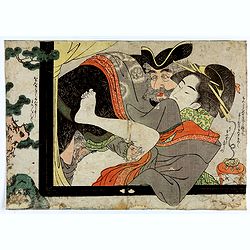
Dutchman and a Maruyama prostitute.
An explicit scene of a Dutchman and a Maruyama prostitute featuring a gray-bearded westerner coupling with a courtesan. The woman protests that she doesn't understand wha...
Place & Date: Late Edo, 1790
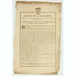
Huile de Calamite.
Oil to heal all ailments, only distributed by François Giramo, who alone owns the secret. Surrounded by a decorative border and the Royal coat-of-arms.With privilege of ...
Place & Date: France, c.1790
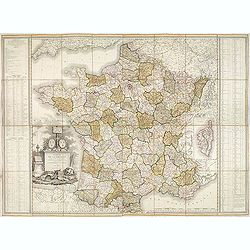
Carte de la France Divisée en 83 Départements et Subdivisée en districts avec les Chefs-lieux de Cantons Présentée à l'Assemblée Nationale et au Roi.
Spectacular folding wall map of France engraved by Barrier. Panels on both sides: "Tableau de la Division de la France d'après les décrets de l'Assemblée national...
Place & Date: Paris, Belleyme, 1791
![[ LANDSKROON ]. Oranda Fune no zu [= Depiction of a Dutch Ship].](/uploads/cache/28003-250x250.jpg)
[ LANDSKROON ]. Oranda Fune no zu [= Depiction of a Dutch Ship].
A very large and extremely detailed Japanese drawing on rice paper of a Dutch ship at the artificial island Deshima, the VOC's outpost in Nagasaki harbour. In the drawing...
Place & Date: Japan, Kansei 4, 2nd month, 9th day, 30 March? 1792
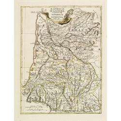
Il Governo di Guascogna con porzione del Governo di Guienna.
Rare regional map of France of the Périgord, Guienne, Gascogne and the Béarn published by Carli Pazzini in Siena.
Place & Date: Siena, 1792
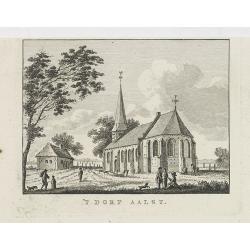
't dorp Aalst.
Rare print of the old church of Aalst (near Eindhoven), from Vaderlandsche gezichten of afbeeldingen.. by J.Bulthuis, printed by H.Gartman in Amsterdam.
Place & Date: Amsterdam, 1786 / 1792
Mapa De la parte de la Isla Formosa sa perteneciente al Emperadotde la China sacado por Ord. De S.M.
Extremely rare map of the west coast of Taiwan, the Punghu or Pescadore Islands, and the Fokien or Fujian coast of China. Several ancient Taiwanese cities are noted, incl...
Place & Date: Manilla, Seminario Conciliar, y Real de San Carlos, 1788-1792
![[Set of five maps] Carte Générale de la Terre ou Mappe Monde](/uploads/cache/41145X-250x250.jpg)
[Set of five maps] Carte Générale de la Terre ou Mappe Monde
Rare and decorative set of five wall maps of the world and the four continents, prepared by Clouet, in very fine bright contemporary coloring. Each map ca. 965 x 1230 mm ...
Place & Date: Paris and Cadiz, Mondhare, 1785-1793
Imperium Russicum, cum regionibus adiacentibus duabus Tabulis ex optima quae A. 1784 tribus foliis comparavit Mappa geographica, aliisque subsidiis delineatum a C. Mannert, Tabula Ima. . .
A detailed map of the European part of the Russian Empire. Scarce map. Copper etching by C. Mannert and edited by Adam Gottlieb Schneider and Johann Christoph Weigel. Man...
Place & Date: Nuremberg, 1794
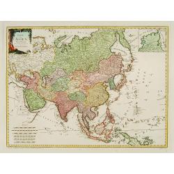
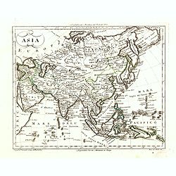
Karte von Asien.
An attractive map of Asia. With a decorative title cartouche in the upper left-hand corner. Engraved by Aarons.Franz Johann Josef von Reilly (Vienna 18 august 1766 - 6 ju...
Place & Date: Vienna 1795
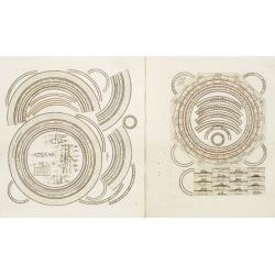
Two sheets for constructing an armillary sphere.
Two sheets for constructing an armillary sphere. Cassini was a geographer and cartographer, but also perspective and architecture carver - one of Giovanni Battista Pirane...
Place & Date: Rome, 1795
Encyclopedie des Voyages. Tom 3 ASIE.
There are in this volume as many as 89 color plates, all done by the author himself. Containing dresses of people of China, Persia, Armenia, Philippines, Java, India, Tar...
Place & Date: Paris, 1796
Carte des découvertes fautes en 1787 dans les Mers de Chine et de Tartarie par les Frégates Françaises la Boussole et l'Astrolabe. . . ée. Feille.
La Pérouse's important large-scale of Northern Japan, Hokkaido, the Kuriles, the tip of Kamschatka, and the northern part of Korea.Showing the track of Perouse from 27 ...
Place & Date: Paris, 1797
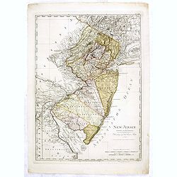
New Jersey entworfen von D.F. Sotzmann. Hamburg bey Carl Ernst Bohn 1796 . . . NO.VIII
Extremely rare map of New Hampshire prepared by Daniel Friedrich Sotzmann for Christopher Ebeling's "Erdbeschreibung von Amerika", a project ended after only te...
Place & Date: Hamburg, Carl Ernst Bohn, 1797
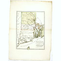
Rhode Island entworfen von D.F. Sotzmann. Hamburg bey Carl Ernst Bohn 1798 . . . NO.V
Extremely rare map of Rhode Island prepared by Daniel Friedrich Sotzmann for Christopher Ebeling's "Erdbeschreibung von Amerika", a project ended after only ten...
Place & Date: Hamburg, Carl Ernst Bohn, 1797
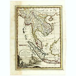
La Penisola delle Indie di la' dal Gange con parte delle Isole della Sonda delineate sulle ultima osservazioni.
First edition on laid paper. Cassini’s splendid early map of Indochina, from Bangladesh in the west to central Borneo in the east, and southern China in the north, to B...
Place & Date: Rome, 1797
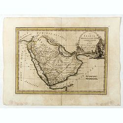
L'Arabia delineata sulle ultime osservazioni.
First edition on laid paper. Cassini’s splendid early map of Arabia.
Place & Date: Rome, 1797
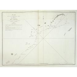
Plan of part of the islands or archipellago of Corea seen in May 1787 by the Boufsole and Astrolabe.
This is a representing the visit of the French Admiral and explorer, le Comte de La Pérouse to Korea in 1786. The tracks of La Perouse are shown.From 'Atlas du Voyage d...
Place & Date: London, 1798
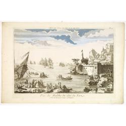
Vue de Malthe du cote du Fort.
A so-called optical print of Valletta seen from the castle. This rare optical print shows people in typical French dresses in the foreground and placed in boats.In the ei...
Place & Date: Paris, 1798
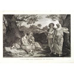
Costumes des habitans de Manille.
A very beautiful print, showing four elegant figures relaxing in a shady glade, two women recline and two stand chatting.After a design of Duché de Vancy and engraved by...
Place & Date: Paris, 1798
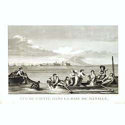
Vue de cavite dans la Baie de Manille.
Two boats and passengers with Cavite Philippines in the background as if was seen from Manila Bay in January 1787. After a design of Gaspard Duchè de Vancy and engraved ...
Place & Date: Paris, 1798
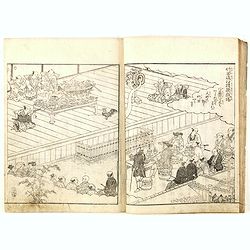
SETTSU MEISHO ZUE. Illustrations of famous places in Settsu.
Settsu Meisho Zue was printed in two series of 8 and 4 volumes. The principal illustrator was Takehara Shunchosai, but many illustrations in the 4 volumes supplement are ...
Place & Date: Osaka, Yanagiwara Kibei, Kansei 8-10 or 1796-1798
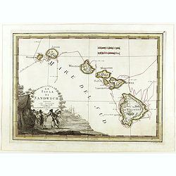
Le Isole di Sandwich delineate sulle osservazioni del Cap Cook.
FIRST EDITION on laid paper. Cassini’s splendid map depicts Sandwich islands, old name for Hawaii islands, at the end of the eighteenth century. The splendid cartouche ...
Place & Date: Rome, 1798
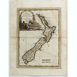
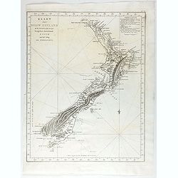
La nuova Zelanda delineate sulle ultima osservazioni del Capitan Cook.
First edition on laid paper Cassini’s splendid early map of New Zealand, being the most decorative version of Captain Cook's map of New Zealand, published in the very s...
Place & Date: Rome, 1798
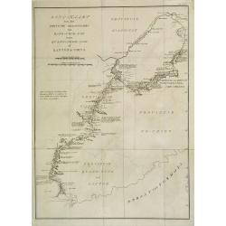
![[Set of 6 maps] Charta öfver Storfurstendömet Finland på Friherre S. G. Hermelins Anstalt och Omkostnad. Sammandragen och författad af C. P. Hällström. Philos. Magister och Auscultant i Kongl. BergsColl. 1799.](/uploads/cache/34482-250x250.jpg)
[Set of 6 maps] Charta öfver Storfurstendömet Finland på Friherre S. G. Hermelins Anstalt och Omkostnad. Sammandragen och författad af C. P. Hällström. Philos. Magister och Auscultant i Kongl. BergsColl. 1799.
This is the beautiful set of key map and separate maps of Samuel Gustav Hermelins map of Finland. The maps have been engraved by Fredrik Akrel, a very skilled and product...
Place & Date: Källa: J.Strang & E.- S. Harju: Suomen karttakirja 1799
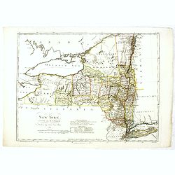
New Yok entworfen von D.F. Sotzmann. Hamburg bey Carl Ernst Bohn 1799 . . . NO.VII
An extremely rare map of New York prepared by Daniel Friedrich Sotzmann for Christopher Ebeling's "Erdbeschreibung von Amerika", a project ended after only ten ...
Place & Date: Hamburg, Carl Ernst Bohn, 1799
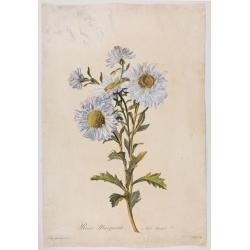
Reine-Marguerite. Aster chinensis. L.
A bouquet of flowers. Engraved by P.F. Le Grand after designs by the Dutch-born Gerard van Spaendonck (1746-1822).Taken from the rare work "Fleurs dessinées d'aprè...
Place & Date: Paris, ca. 1800
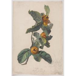
Neflier cultivé. Mespilus germanica. L.
A bouquet of flowers. Engraved by P.F. Le Grand after designs by the Dutch born Gerard van Spaendonck (1746-1822).Taken from the rare work "http://www.swaen.com/Fleu...
Place & Date: Paris, ca.1800
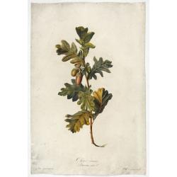
Chêne commun.
Engraved by P.F. Le Grand after designs by the Dutch born Gerard van Spaendonck (1746-1822).Taken from the rare work "Fleurs dessinées d'après nature. . . receuil ...
Place & Date: Paris, c. 1800
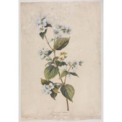
Seringat odorant. Philadelphus coronarius. L.
Bouquet of Seringats. A bouquet of flowers. Engraved by P.F. Le Grand after designs by the Dutch born Gerard van Spaendonck (1746-1822).Taken from the rare work "Fle...
Place & Date: Paris, c. 1800
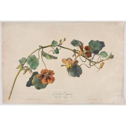
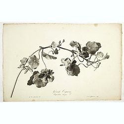
Grande Capucine Tropoeolum majus. L.
The true Nasturtium, stipple engraving by P.F. Le Grand after designs by the Dutch-born Gerard van Spaendonck (1746-1822).Taken from the rare work "Fleurs dessinées...
Place & Date: Paris, c.1800
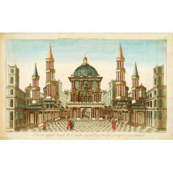
Vue du sperbe Temple de St.Sophie .. a Constantinople.
A fanciful depiction of the Aya Sofya in Istanbul. In the eighteenth and nineteenth centuries there were many popular speciality establishments in Paris, Augsburg and Lon...
Place & Date: Paris, 1800
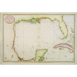
Carte des côtes du Golfe du Mexique compris entre la pointe sud de la presqu'Ile de la Floride et la pointe nord de la presqu'Ile d'Yucatan: Dresée d'après le observations et las plans des espagnols, ...
Detailed and important early chart of the Gulf Coast and Florida and dated 1800. First French edition of "the first printed [map] to show and name Galveston Bay&qu...
Place & Date: Paris, 1800
Reis-kaart van het Britsche gezantschap van Hang-choe-foe naar Quang-choe-foe of Kanton in China.
Uncommon map of eastern part of China, showing a journey of the English Embassy from Hangzhou (south of Shanghai) to Guangzhou (Canton). The maps is giving a wealth of in...
Place & Date: Netherlands, c.1800
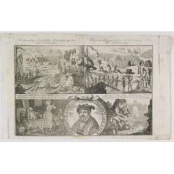
Botanibay, Englischer Verweisungs Ort fur Verbrecher. / Laijene Franzosicher Verweisungs Ort fur Verbrecher.
Copper engraving with four scenes and one portrait of Frederick III of Saxony on one sheet. In the upper part fanciful views of Botany Bay with English and French settlem...
Place & Date: Zittau, 1798-1800
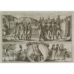
Erfolgte Kapitulation zwischen dem General Bonaparte und den Gross Leister von Malta. Vor der Hauptstadt Walette zu Maltha, am 10 Juni 1798.
Copper engraving with three scenes and one portrait on one sheet. In upper a view of Bonaparte arriving at Valletta. Published in "Allgemeine Welt-Chronik oder neue ...
Place & Date: Zittau, 1798-1800
![[ Manuscript map of the Ligurian coast from Pietra to Genova ].](/uploads/cache/26627-250x250.jpg)
[ Manuscript map of the Ligurian coast from Pietra to Genova ].
Very detailed French manuscript map of the Ligurian coast from Pietra and Finale, Savone to Genoa with the Maritime Alps in the background. The Liguria coast borders to n...
Place & Date: France, ca. 1790-1800
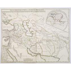
Partie Orientale de la Carte des Anciennes Monarchies. . .
This map depicts the eastern part of the Ancient World, Partie Occidentale de la Carte des Anciennes Monarchies including the Near East, Cyprus, Black Sea, Caspian Sea, I...
Place & Date: Paris, ca. 1800
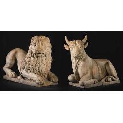
Lion and Bull made of terracotta.
Very fine terracotta figure of a lion symbolizing the continent of Africa. The Bull symbolizing Europe.The items will be dispatched in 4 wooden crates from Belgium. Pleas...
Place & Date: Netherlandisch , 1780~1800
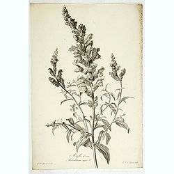
Mufle de veau. Antirrhinum majus L.
Bouquet of Common Snapdragons, engraving by P.F. Le Grand after designs by the Dutch born Gerard van Spaendonck (1746-1822).Taken from the rare work "Fleurs dessiné...
Place & Date: Paris, c.1800
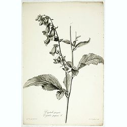
Digitale pourprée. Digitalis purpurea L.
The foxglove, engraving by P.F. Le Grand after designs by the Dutch born Gerard van Spaendonck (1746-1822).Taken from the rare work "Fleurs dessinées d'après natur...
Place & Date: Paris, c.1800
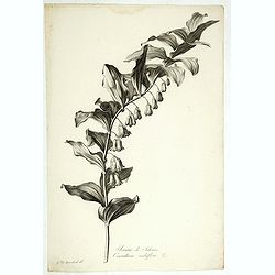
Sceau de Salomon. Convallaria multiflora L.
King Solomon's Seal or David's Harp, engraving by P.F. Le Grand after designs by the Dutch born Gerard van Spaendonck (1746-1822).Taken from the rare work "Fleurs de...
Place & Date: Paris, c.1800
Grande Capucine. Tropaeolum majus. L.
Indian cress or monks cress, engraving by P.F. Le Grand after designs by the Dutch born Gerard van Spaendonck (1746-1822).Taken from the rare work "Fleurs dessinées...
Place & Date: Paris, c.1800
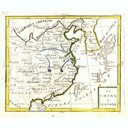
La China e Giapone.
Uncommon map of China, Korea, Japan and Taiwan (I.Formosa), only one town labeled, Tayoan. Very strange shape for Japan.The map is of interest for the use of Mar di Corea...
Place & Date: Italy, ca. 1800
Deutschlands Postkarte begraenzt von Oesterreich, Preussen, Frankreich, Holland, Italien und der Schweiz. . .
Detailed and important post road map prepared by Ignaz Heymann. The map shows, the Low Countries, Germany, Poland, Austria, Hungary, etc.Borders in original out-line colo...
Place & Date: Triest, 1800
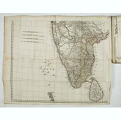
Recueil de cartes géographiques pour la description de l'Indostan . . .
First French edition, the maps revised by Jean Nicholas Buache. The English original edition was published in London in 1783 by Brown under the title "Memoir of a ...
Place & Date: Paris, Poignée, an VIII = 1800
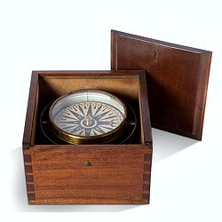
Early 19th century magnetic dry card compass with wooden bowl,
Brass dry rose marine compass, in its mahogany case. The mariner's compass, which enabled mariners to know the direction in which they were sailing, has always been one o...
Place & Date: ca. 1800
Shinkan Nagasaki no Dzu.
The oldest of these so-called Nagasaki pictures (Nagasaki-zu) were two panoramic prints by the artist Chikujuken that served as guides to the city of Nagasaki for visitor...
Place & Date: Nagasaki, 1801
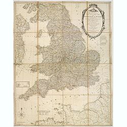
Bowles's new four-sheet map of England and Wales. . .
Bowles's new four-sheet map of England and Wales: Comprehending all the Cities, Boroughs, Market and Sea-Port Towns, Villages, Lakes, Rivers, Forests, Ruins, Canals, and ...
Place & Date: London, 1801
Kaart Van Nieuw Zeeland in de Jaaren 1769 en 1770 bezogt door den Luitenant J. Cook met het Schip De Endeavour.
A uncommon issue of this key map of New Zealand from the Dutch edition of Cook's map of New Zealand, published in 'Reize rondom de Waereld door James Cook', a Dutch editi...
Place & Date: Leyden, Amsterdam & The Hague: Honcoop, Allart & van Cleef, 1795-1801
![Schat-Kamer ofte konst der stuurlieden, inhoudende Een duidelyke onderwyzinge in de navigatie. . . [bound with] Geographische Tadfel vande Graaden.. Voornaamste Zee-haavens. . .](/uploads/cache/33114-250x250.jpg)
Schat-Kamer ofte konst der stuurlieden, inhoudende Een duidelyke onderwyzinge in de navigatie. . . [bound with] Geographische Tadfel vande Graaden.. Voornaamste Zee-haavens. . .
Rare and important manual originally prepared by Klaas de Vries and improved by Evert Floryn and S.Hollander of the "Schat-Kamer ofte konst der stuurlieden" (Tr...
Place & Date: Amsterdam, Wed. Gerard Hulst van Keulen, 1802

United States of North America. Carte des Etats-Unis de l'Amerique Septentrionale / copiée et gravée sur celle d'Arrowsmith, corrigée et considérablement augmentée... par P. F. Tardieu...
FIRST EDITION. An impressive wall map here in 4 unjoined sheets and large margins. RARE in these untouched, full sheets. Recorded examples are usually offered as folding ...
Place & Date: Paris: An XI - 1802
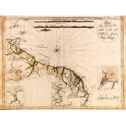
Guyana, Surinam, Amapa.
Very rare Ottoman printed map of Guyana, Suriname and Amapa. With Trinidad, an inset map of the mouth of the Rivers Essequibo, Courantyne, Suriname with Paramaribo.From C...
Place & Date: Üsküdar (Istanbul), 1803
![Bunken Edo oezu. [Tokyo]](/uploads/cache/12826-250x250.jpg)
Bunken Edo oezu. [Tokyo]
Based on map by Ochikochi Doin. Oriented with north to the right. An extraordinary wood block-printed town-plan now-a-day Tokyo, and a fine example of Edo cartography. Th...
Place & Date: Edo, ca. 1803
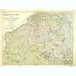
Teatro della guerra nelle Flandre Austriache e Francesi. . .
Rare folio-sized map of Belgium by Antonio Zatta e Figli, from a never-finished atlas by the ‘Società Calcografia’, a partnership of the two main Venetian publishers...
Place & Date: Venise, 1803
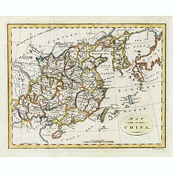
Map of China.
Showing China, Taiwan and Korea, divided into provinces with the main cities marked. The map is of interest for the use of Sea of Corea, the sea between Korea and Japan, ...
Place & Date: London, 1804
A Map of the Environs of Constantinople Drawn from a great number of accurate astronomical & geographical manuscripts and printed documents, by A. Arrowsmith 1801 and 1804.
Arrowsmith’s large and detailed map of the Ottoman Empire and the Black Sea, with Cyprus, Crete and the Greek Islands in the Mediterranean Sea, Albania, Bosnia and Herz...
Place & Date: London, No.10 Soho Square, 4th September 1804
![[Butterflies]](/uploads/cache/25587-250x250.jpg)
[Butterflies]
Plate CXXIV from Carl Gustav Jablonsky and J.F.W. Herbst: "Natursystem aller bekannten in- und ausländischen Insecten", engraved by Bodenehr. Carl Gustav Jablo...
Place & Date: Berlin, J. Pauli, 1785-1806
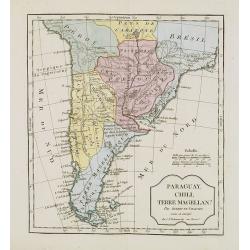
Paraguay, Chili, Terre Magellan ?
Map of Paraguay, Chili, and Argentina . By C. F. Delamarche, successor of Robert de Vaugondy, Geographer.
Place & Date: Paris, 1794 -1806
![Morokoshi Meisho Zue [Illustrated Description of Famous Sites of China].](/uploads/cache/34118-250x250.jpg)
Morokoshi Meisho Zue [Illustrated Description of Famous Sites of China].
Published in Osaka, Kawachiya Genhichiro, et al. [8 book sellers], slightly later issue but apparently in Edo period, using all the same woodblocks of original first edit...
Place & Date: Osaka, Edo, slightly later than Bunka 3, year of the tiger - 1806
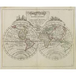
Mappe-Monde ou Description du Glôbe Terrestre Assujettie aux Observs Astronoms.
Double hemisphere map with a curious shape for Australia, from Atlas moderne portatif composé de vingt-huit cartes sur toutes les parties du globe terrestre .. A l'usage...
Place & Date: Paris, Prudhomme, Levrault, Debray, 1806
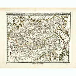
Siberie ou Russie Asiatique, Tartarie Chinoise, Pays des Eluts et Isles du Japon.
Map of the Kamchatka peninsula, Russian Far East., Korea, Japan, with Hokkaido labeled "Terre del Jeso".By C. F. Delamarche, successor of Robert de Vaugondy, Ge...
Place & Date: Paris, 1794 - 1806
Asia.
Uncommon map of Asia. Engraved by Marco di Pietro.The map is of interest for the use of G. di Corea, for the sea between Korea and Japan.Published by Carlo Antonio Barbie...
Place & Date: Milan, 1807
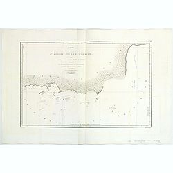
Carte de L'Archipel de La Recherche a la partie Occidentale de la Terre de Nuyts. . .
A large and detailed chart of the southern West Australian coast centered on the region of Esperance and the surrounding islands.Terre de Nuyts is the name that was forme...
Place & Date: Paris 1807
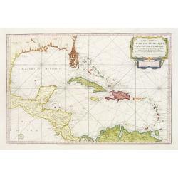
Carte Réduite Du Golphe Du Mexique Et Des Isles De L' Amérique..
A well engraved and highly detailed chart prepared by Bellin of the Gulf of Mexico and the Caribbean. In addition to a magnificent title cartouche and a color key to the ...
Place & Date: Paris dated year 17, or 1808
Carta militar das principaes estradas de Portugal.
Rare road map of Portugal in a scale of ca 1:470000. At the bottom right and left legends in Portuguese and French. Engraved by Romão Eloy de Almeida, who was a Portugue...
Place & Date: Lisbone, 1808
![Boats of the Friendly Islands. [together with] A Sailing Canoe of Otaheite.](/uploads/cache/30041-250x250.jpg)
Boats of the Friendly Islands. [together with] A Sailing Canoe of Otaheite.
Early view of Queen charlotte's sound, taken from "Views in the South Seas" being a very important and early views depicting scenes encountered while employed a...
Place & Date: London, Boydell and Co., 1808
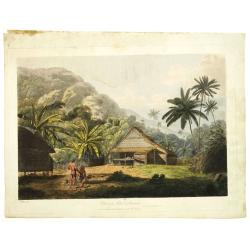
View of the harbour of Taloo, in the island of Eimeo.
John Webber View of the Harbour of Taloo on Moorea (Society Islands), from "Views in the South Seas" being a very important and early views depicting scenes enc...
Place & Date: London, Boydell and Co., 1808
![A Toopapaoo of a Chief, with a priest making his offering to the Morai, in Huoheine. [Huaheine - the Society Islands]](/uploads/cache/30045-250x250.jpg)
A Toopapaoo of a Chief, with a priest making his offering to the Morai, in Huoheine. [Huaheine - the Society Islands]
A view of a chief's raised burial chamber in Huaheine, Society Islands, taken from "Views in the South Seas" being a very important and early view depicting sce...
Place & Date: London, Boydell and Co., 1808
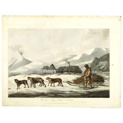
The narta, or Sledge for burdens in Kamtschatka.
The narta, or Sledge for burdens in Kamtschatka, taken from "Views in the South Seas" being a very important and early views depicting scenes encountered while ...
Place & Date: London, Boydell and Co., 1808
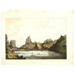
View in the island of Cracatoa.
Early view of the volcano Krakatoa (Indonesian name: Krakatau), on the Indonesian island of Rakata in the Sunda Strait, taken from "Views in the South Seas" bei...
Place & Date: London, Boydell and Co., 1808
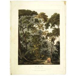
The Fan palm, in the island of Cracatoa.
The Fan palm, on the island of Krakatoa (Indonesian name: Krakatau), in the Sunda Strait, taken from "Views in the South Seas" being a very important and early ...
Place & Date: London, Boydell and Co., 1808
A view in Oheitepeha Bay in the Island of Otaheite. (Tahiti)
A view of Vaitepiha Bay (Tahiti), with a mountainous landscape, with a river in the centre, a small canoe, Tahitian houses to the right, and a Tahitian couple in the left...
Place & Date: London, Boydell and Co., 1808
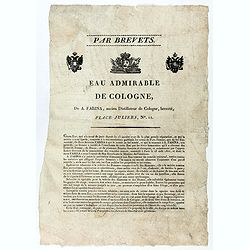
Par Brevets. / Eau admirable de Cologne, de A. Farina, ancien Distillateur de Cologne, breveté, Place Juliers, N°11.
Advertising Broadsheet promoting the toilet water "Eau de Cologne". Ornated with the royal coat of arms of France and 2 two-headed eagles. With the printed sign...
Place & Date: After 1810
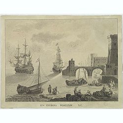
Les environs d'Ostende. XII.
Beautiful view of Oostende. A somewhat fanciful depiction of the harbor of Oostende, with merchant on the foreground and large vessels in the sea. The item is signed (Dre...
Place & Date: Belgium, c. 1811
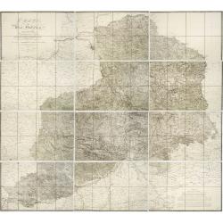
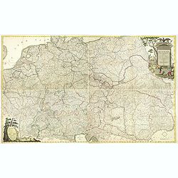
Carte von West=Gallizien welche auf allerhöchsten Befehl Seiner Kaiserlich oesterreichischen und Königlich apostolischen Majestät in den Jahren 1801 bis 1804. . .
Important early map of Western Galicia, as given to Austria by the third Partition of Poland (1795). Due to its long development period, a rare map rich in detail shows t...
Place & Date: Vienna, (1808) after 1811