Browse Listings in Australia & Oceania > Pacific islands
![Vue de l'Isle d'Otahiti et de plusieurs Pirogues. [Tome II Pl. 11.]](/uploads/cache/26102-250x250.jpg)
Vue de l'Isle d'Otahiti et de plusieurs Pirogues. [Tome II Pl. 11.]
View of the Island of Tahiti and dugouts. From the French edition of James Cook's first voyage entitled Relation des voyages entrepris par ordre de sa Majesté Britanniqu...
Date: Paris, 1773
![Vue de l'Isle d'Huaheine avec La Maison de Dieu, et un petit Autel couvert d'offrandes. [Tome III Pl. 4.]](/uploads/cache/26108-250x250.jpg)
Vue de l'Isle d'Huaheine avec La Maison de Dieu, et un petit Autel couvert d'offrandes. [Tome III Pl. 4.]
A view of the Island of Huaheine, Tahiti, a beautiful tropical Owharra tree in the foreground and a depiction of the House of God with its offertory. From the French edit...
Date: Paris, 1773
![Emouchoir des Otahitiens avec ses manches. [Tome II Pl. 13.]](/uploads/cache/26098-250x250.jpg)
Emouchoir des Otahitiens avec ses manches. [Tome II Pl. 13.]
The print depicts three ceremonial fly-whisks from Tahiti. Each object features ornate carved handles with anthropomorphic figures and long flowing fibers, accompanied by...
Date: Paris, 1773
![Manière dont on expose les morts à Otahiti. [Tome II Pl. 16.]](/uploads/cache/26113-250x250.jpg)
Manière dont on expose les morts à Otahiti. [Tome II Pl. 16.]
A view of a Tahitian funeral home in a beautiful landscape. Engraved by Demouchy. From the French edition of James Cook's first voyage entitled Relation des voyages entre...
Date: Paris, 1773
![[HAWAII] - Plan de la baye de Karakakooa.](/uploads/cache/48173-250x250.jpg)
[HAWAII] - Plan de la baye de Karakakooa.
Beautiful map showing the islands forming the Hawaiian archipelago, drawn up during Cook's third voyage: Oneeheow or Ni'ihau, Atooi or Kauai, Woahoo or O'ahu, Morotoi or ...
Date: Paris, 1774
![Cession de l'Isle d'Ohahiti au Capitaine Wallis par la Reine Obéréa. [Tome II Pl. 2.]](/uploads/cache/26111-250x250.jpg)
Cession de l'Isle d'Ohahiti au Capitaine Wallis par la Reine Obéréa. [Tome II Pl. 2.]
Queen Oberea's transfer ceremony to Captain Wallis on Tahiti.Engraved by François Godefroi. From the French edition of James Cook's first voyage entitled Relation des vo...
Date: Paris, 1774
![Donna dell' Isola d' Erramanga una delle nuove Ebridi nel Mar Pacifico. / Femme de l'Isle d'Erramanga une des nouvelles Hebrides dans la Mer Pacifique. [Vanuatu]](/uploads/cache/26396-250x250.jpg)
Donna dell' Isola d' Erramanga una delle nuove Ebridi nel Mar Pacifico. / Femme de l'Isle d'Erramanga une des nouvelles Hebrides dans la Mer Pacifique. [Vanuatu]
Full portrait of a woman, native of the island of Erramanga in the New Hebrides, officially the New Hebrides Condominium, the colonial name for the island group in the So...
Date: Venice, Antonio Zatta, c.1790
![Donna dell' Isola di Mallicolo una delle nuove Ebridi nel Mar Pacifico del Sud. / Femme de l' Isle d'Erramanga... [Vanuatu]](/uploads/cache/26397-250x250.jpg)
Donna dell' Isola di Mallicolo una delle nuove Ebridi nel Mar Pacifico del Sud. / Femme de l' Isle d'Erramanga... [Vanuatu]
Full portrait of a woman, a native of the island of Mallico in the New Hebrides, officially the New Hebrides Condominium, the colonial name for the island group in the So...
Date: Venice, Antonio Zatta, c.1790
![Donna dell' Isola di Tanna, una delle nuove Ebridi nel Mar Pacifico. / Femme de l' Isle de Tanna, une des nouvelles Hebrides dans la Mer Pacifique. [Vanuatu]](/uploads/cache/26398-250x250.jpg)
Donna dell' Isola di Tanna, una delle nuove Ebridi nel Mar Pacifico. / Femme de l' Isle de Tanna, une des nouvelles Hebrides dans la Mer Pacifique. [Vanuatu]
Full portrait of a woman, a native from the island of Mallico in the New Hebrides, officially the New Hebrides Condominium, the colonial name for the island group in the ...
Date: Venice, Antonio Zatta, c.1790
![Uomo dell' Isola di Tanna, una delle nuove Ebridi nel Mar Pacifico. / Homme de l' Isle de Tanna, une des nouvelles Hébrides dans la Mer du Pacifique. [Vanuatu]](/uploads/cache/26399-250x250.jpg)
Uomo dell' Isola di Tanna, una delle nuove Ebridi nel Mar Pacifico. / Homme de l' Isle de Tanna, une des nouvelles Hébrides dans la Mer du Pacifique. [Vanuatu]
Full portrait of a man from the island of Tanna in the Pacific. New Hebrides, officially the New Hebrides Condominium was the colonial name for the island group in the So...
Date: Venice, Antonio Zatta, c.1790

Capo della flotta degli Otahiti nel Mar Pacifico del Sud. / Chef de la flotte des Otahiti dans la Mer Pacifique du Sud.
Full portrait of the captain of the Otahiti flotilla, from Tahiti. A rare engraving from "Raccolata di stampe ... di varie nazioni". From the original drawing...
Date: Venice, Antonio Zatta, c.1790

Potatow Capo dei Tahiti Isola nel Mare Pacifico del Sud. / Potatow Chef de Tahiti Isle dans la Mer Pacifique du Sud.
Full portrait of the Hawaiian chief Potatow. A rare engraving from "Raccolata di stampe ... di varie nazioni". From the original drawing by William Hodges, w...
Date: Venice, Antonio Zatta, c.1790

Otoo, Re di Tahiti Isola nel Mar Pacifico del Sud. / Otoo, Roi de Tahiti Isle dans la Mer Pacifique du Sud.
Full portrait of King Otoo from Tahiti. A rare engraving from "Raccolata di stampe ... di varie nazioni". From the original drawing by William Hodges, who acco...
Date: Venice, Antonio Zatta, c.1790

Donna dell' Isola di Pasqua, o terra di Davis nel Mar del Sud. / Femme de l' Isle de Pâques ou terre de Davis dans la Mer du Sud.
Full portrait of a woman, a native of Easter Island, a Chilean territory, is a remote volcanic island in PolynesiaFrom "Raccolta di stampe." a series of histori...
Date: Venice, Antonio Zatta, c.1790

Uomo dell' Isola di Pasqua o Terra di Davis nel Mar del Sud. / Homme de l' Isle de Pâquesou Terra de Davis dans la Mer du Sud.
Full portrait of a native from Easter Island. Easter Island, a Chilean territory, is a remote volcanic island in Polynesia.From "Raccolta di stampe," a series o...
Date: Venice, Antonio Zatta, c.1790

Uomo della nuova Caledonia Isola del Mar Pacifico. / Homme de la nouvelle Calédonie Isle dans la Mer Pacifique.
Full portrait of a native from New Caledonia. A rare engraving from "Raccolata di stampe ... di varie nazioni". From the original drawing by William Hodges, who...
Date: Venice, Antonio Zatta, c.1790
![Le Isole di Sandwich delineate sulle osservazioni del Cap Cook. [Hawaii]](/uploads/cache/43195-250x250.jpg)
Le Isole di Sandwich delineate sulle osservazioni del Cap Cook. [Hawaii]
FIRST EDITION on laid paper. Cassini’s splendid map depicts the Sandwich Islands, the old name for the Hawaiian Islands, at the end of the eighteenth century. The splen...
Date: Rome, 1798
![A Toopapaoo of a Chief, with a priest making his offering to the Morai, in Huoheine. [Huaheine - the Society Islands]](/uploads/cache/30045-250x250.jpg)
A Toopapaoo of a Chief, with a priest making his offering to the Morai, in Huoheine. [Huaheine - the Society Islands]
A view of a chief's raised burial chamber in Huaheine, Society Islands, taken from "Views in the South Seas" being a very important and early view depicting sce...
Date: London, Boydell and Co., 1808
![[New Caledonians ].](/uploads/cache/26367-250x250.jpg)
[New Caledonians ].
Aquatint depicting New Caledonians engraved by Biasioli. Plate N° 71. From Giulio Ferrario's work Le Costume Ancien et Moderne ou Histoire du gouvernement, de la milice,...
Date: Milan, 1827
![[Pirogues in the bay of the voyage of the Resolution. The Marquesas Islands ].](/uploads/cache/26373-250x250.jpg)
[Pirogues in the bay of the voyage of the Resolution. The Marquesas Islands ].
Aquatint depicting men in pirogues in the Bay of the Resolution from the Marquesas Islands engraved by Biasioli. Plate N° 91. From Giulio Ferrario's work Le Costume Anci...
Date: Milan, 1827
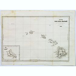
Carte des Iles Hawaii.
A lovely small map of the complete chain of Pacific islands known today as the Hawaiian islands, from Dumont d'Urville's atlas "Voyage pittoresque autour du Monde.&q...
Date: Paris, 1834
