Browse Listings in Australia & Oceania
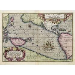
Maris Pacifici.
From the rare Dutch text edition of the Theatrum of which according to van den Broecke only 100 copies are printed.This was the first printed map to be devoted solely to ...
Place & Date: Antwerp, 1598
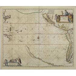
Mar del Zur, Hispanis Mare Pacificum.
Janssonius' fine chart of the Pacific including the west coast of America with California shown as an island, Japan and a small Australian coastline. This is the earliest...
Place & Date: Amsterdam, 1650
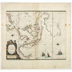
Paskaerte Zynde t'Oosterdeel Van Oost Indien, met alle de Eylanden daer ontrendt geleegen van C. Comorin tota aen Iapan.
An eye-catching chart of Pieter Goos' sea chart of Australia, Southeast Asia, China, Japan, Korea and India. The chart shows the regions from Cape Comorin (Southern India...
Place & Date: Amsterdam, 1669
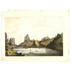
![Vue de la Rivière d'Endeavour sur la Côte de la Nouvelle Hollande ou le Vaisseau fut mis à la bande. [Tome IV Pl. 1ère.]](/uploads/cache/26093-250x250.jpg)
Vue de la Rivière d'Endeavour sur la Côte de la Nouvelle Hollande ou le Vaisseau fut mis à la bande. [Tome IV Pl. 1ère.]
The first known landscape drawing of the east coast of Australia. A View of the Endeavour River, on the coast of New Holland, where the ship was laid on shore, in order t...
Place & Date: Paris, 1773
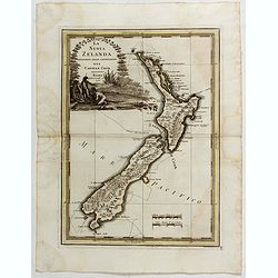
La Nuova Zelanda tracorsa nel 1769 e 1770 dal Cook commandante dell' Endeavour Vascello di S.M.Britannica.
Antonio Zatta’s map of New Zealand is not only one of the first to show the results of Cook’s voyages, but is also one of the most attractive of the islands. Consider...
Place & Date: Venise, 1778
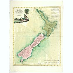
La nuova Zelanda delineate sulle ultima osservazioni del Capitan Cook.
First edition on laid paper Cassini’s splendid early map of New Zealand, being the most decorative version of Captain Cook's map of New Zealand, published in the very s...
Place & Date: Rome, 1798
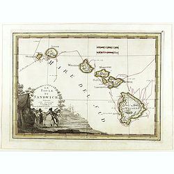
Le Isole di Sandwich delineate sulle osservazioni del Cap Cook.
FIRST EDITION on laid paper. Cassini’s splendid map depicts Sandwich islands, old name for Hawaii islands, at the end of the eighteenth century. The splendid cartouche ...
Place & Date: Rome, 1798
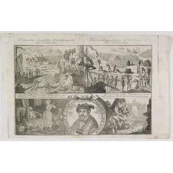
Botanibay, Englischer Verweisungs Ort fur Verbrecher. / Laijene Franzosicher Verweisungs Ort fur Verbrecher.
Copper engraving with four scenes and one portrait of Frederick III of Saxony on one sheet. In the upper part fanciful views of Botany Bay with English and French settlem...
Place & Date: Zittau, 1798-1800
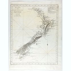
Kaart Van Nieuw Zeeland in de Jaaren 1769 en 1770 bezogt door den Luitenant J. Cook met het Schip De Endeavour.
A uncommon issue of this key map of New Zealand from the Dutch edition of Cook's map of New Zealand, published in 'Reize rondom de Waereld door James Cook', a Dutch editi...
Place & Date: Leyden, Amsterdam & The Hague: Honcoop, Allart & van Cleef, 1795-1801
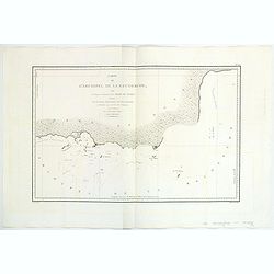
Carte de L'Archipel de La Recherche a la partie Occidentale de la Terre de Nuyts. . .
A large and detailed chart of the southern West Australian coast centered on the region of Esperance and the surrounding islands.Terre de Nuyts is the name that was forme...
Place & Date: Paris 1807
View of the harbour of Taloo, in the island of Eimeo.
John Webber View of the Harbour of Taloo on Moorea (Society Islands), from "Views in the South Seas" being a very important and early views depicting scenes enc...
Place & Date: London, Boydell and Co., 1808
![A Toopapaoo of a Chief, with a priest making his offering to the Morai, in Huoheine. [Huaheine - the Society Islands]](/uploads/cache/30045-250x250.jpg)
A Toopapaoo of a Chief, with a priest making his offering to the Morai, in Huoheine. [Huaheine - the Society Islands]
A view of a chief's raised burial chamber in Huaheine, Society Islands, taken from "Views in the South Seas" being a very important and early view depicting sce...
Place & Date: London, Boydell and Co., 1808
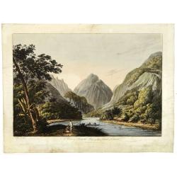
A view in Oheitepeha Bay in the Island of Otaheite. (Tahiti)
A view of Vaitepiha Bay (Tahiti), with a mountainous landscape, with a river in the centre, a small canoe, Tahitian houses to the right, and a Tahitian couple in the left...
Place & Date: London, Boydell and Co., 1808
![Boats of the Friendly Islands. [together with] A Sailing Canoe of Otaheite.](/uploads/cache/30041-250x250.jpg)
Boats of the Friendly Islands. [together with] A Sailing Canoe of Otaheite.
Early view of Queen charlotte's sound, taken from "Views in the South Seas" being a very important and early views depicting scenes encountered while employed a...
Place & Date: London, Boydell and Co., 1808
![Terre de Diemen. Arra-Maida. [plate XII]](/uploads/cache/46275-250x250.jpg)
Terre de Diemen. Arra-Maida. [plate XII]
A portrait of a female Tasmanian Aboriginal Arra-Maida, after the original sketches by Lesueur, from Voyage de découvertes aux terres Australes by François Péron, 1824...
Place & Date: Paris, 1824
![Terre de Diemen. Grou-Agara. [plate X]](/uploads/cache/46273-250x250.jpg)
Terre de Diemen. Grou-Agara. [plate X]
A portrait of the Tasmanian Aboriginal Grou-Agara, after the original sketches by Lesueur, from Voyage de découvertes aux terres Australes by François Péron, 1824.The ...
Place & Date: Paris, 1824
![Nouvelle-Hollande. Gnoung-A-Gnougn-A, Mour-Re-Mour-Ga ( Dit Collins). [plate XVII]](/uploads/cache/46280-250x250.jpg)
Nouvelle-Hollande. Gnoung-A-Gnougn-A, Mour-Re-Mour-Ga ( Dit Collins). [plate XVII]
A portrait of a male Tasmanian Aboriginal Gnoung-A-Gnougn-A, Mour-Re-Mour-Ga ( Dit Collins) by Lesueur, from Voyage de découvertes aux terres Australes by François Pér...
Place & Date: Paris, 1824
![Terre de Diemen. Ourlaga. [plate IX]](/uploads/cache/46272-250x250.jpg)
Terre de Diemen. Ourlaga. [plate IX]
A portrait of the female Tasmanian Aboriginal Ourlaga, after the original sketches by Lesueur, from Voyage de découvertes aux terres Australes by François Péron, 1824....
Place & Date: Paris, 1824
![Nouvelle-Hollande - Y-Erran-Gou-La-Ga. [plate XIX]](/uploads/cache/46341-250x250.jpg)
Nouvelle-Hollande - Y-Erran-Gou-La-Ga. [plate XIX]
A portrait of a male Tasmanian Aboriginal Y-Erran-Gou-La-Ga by Lesueur, from Voyage de découvertes aux terres Australes by François Péron, 1824.The French expedition u...
Place & Date: Paris, 1824
![Nouvelle-Hollande: Nelle Galles du sud - Norou-Gal-Derri s'avancant pour combattre. [plate XX]](/uploads/cache/46342-250x250.jpg)
Nouvelle-Hollande: Nelle Galles du sud - Norou-Gal-Derri s'avancant pour combattre. [plate XX]
A portrait of a male Tasmanian Aboriginal Norou-Gal-Derri by Lesueur, from Voyage de découvertes aux terres Australes by François Péron, 1824.The French expedition und...
Place & Date: Paris, 1824
![Nouvelle-Hollande: Nelle. Galles du sud - Navigation. [plate XXIII]](/uploads/cache/46345-250x250.jpg)
Nouvelle-Hollande: Nelle. Galles du sud - Navigation. [plate XXIII]
An aboriginal camp fire, with a pirogue and two men navigating , after the original sketches by Lesueur, from Voyage de découvertes aux terres Australes by François Pé...
Place & Date: Paris, 1824
![Nouvelle-Hollande: Terre dEndracht - Cabane des naturels de la Presqu'Ile de Péron. [plate XXIV]](/uploads/cache/46346-250x250.jpg)
Nouvelle-Hollande: Terre dEndracht - Cabane des naturels de la Presqu'Ile de Péron. [plate XXIV]
An aboriginal camp fire, after the original sketches by Lesueur, from Voyage de découvertes aux terres Australes by François Péron, 1824.The French expedition under Ni...
Place & Date: Paris, 1824
![Nouvelle-Hollande: Ile Bernier. - Kanguroo a Bandes [plate XXVII]](/uploads/cache/46349-250x250.jpg)
Nouvelle-Hollande: Ile Bernier. - Kanguroo a Bandes [plate XXVII]
Plate illustrating Kanguroo a Bandes by Lesueur, from Voyage de découvertes aux terres Australes by François Péron, 1824.The French expedition under Nicolas Baudin, wa...
Place & Date: Paris, 1824
![Nouvelle-Hollande: Ile King. - L'Eléphant -marin ou Phoque à trompe. [plate XXXII]](/uploads/cache/46354-250x250.jpg)
Nouvelle-Hollande: Ile King. - L'Eléphant -marin ou Phoque à trompe. [plate XXXII]
Plate illustrating seals by Lesueur, from Voyage de découvertes aux terres Australes by François Péron, 1824.The French expedition under Nicolas Baudin, was commission...
Place & Date: Paris, 1824
![Nouvelle-Hollande: Nouvelle Galles du sud. -Dasyure à longue queue. [plate XXXIII]](/uploads/cache/46355-250x250.jpg)
Nouvelle-Hollande: Nouvelle Galles du sud. -Dasyure à longue queue. [plate XXXIII]
Plate illustrating the Dasyure, who lives in Tasmania and south-eastern Australia. Plate by Lesueur, from Voyage de découvertes aux terres Australes by François Péron,...
Place & Date: Paris, 1824
![Nouvelle-Hollande Nelle Galles du sud. Vue d'une partie de la ville de Sydney capitale des Colonies Anglaises aux Terres Australes . . . [plate XXXVII]](/uploads/cache/46359-250x250.jpg)
Nouvelle-Hollande Nelle Galles du sud. Vue d'une partie de la ville de Sydney capitale des Colonies Anglaises aux Terres Australes . . . [plate XXXVII]
Important view of Sydney Cove from Dawes Point looking eastward from Voyage de découvertes aux terres Australes by François Péron, 1824. This is one of the earliest de...
Place & Date: Paris, 1824
![Plan de la partie sud des Iles Furneaux [with] Carte générale de la Partie Sud-Est de la Terre de Diémen . . .](/uploads/cache/46365-250x250.jpg)
Plan de la partie sud des Iles Furneaux [with] Carte générale de la Partie Sud-Est de la Terre de Diémen . . .
Two maps on one sheet, on top a map of the southern portion of Cape Barren Island, Clarke Island, and islets in the southern part of the Furneaux Group.With in lower part...
Place & Date: Paris, 1824
![Plan de la Baie Laplace [with] Esquisse du Port Western [with] Plan des Iles Forestier [with] Esquisse du Port Champagny.](/uploads/cache/46372-250x250.jpg)
Plan de la Baie Laplace [with] Esquisse du Port Western [with] Plan des Iles Forestier [with] Esquisse du Port Champagny.
Four maps on one sheet, Laplace Bay, Western Harbour, Forestier islands and Champagny Harbour, from Voyage de découvertes aux terres Australes by François Péron, 1824....
Place & Date: Paris, 1824
![Terre de Diemen. Paraberi. [plate XI]](/uploads/cache/46274-250x250.jpg)
Terre de Diemen. Paraberi. [plate XI]
A portrait of the Tasmanian Aboriginal Paraberi, after the original sketches by Lesueur, from Voyage de découvertes aux terres Australes by François Péron, 1824.The Fr...
Place & Date: Paris, 1824
![Terre de Diemen. Bara-Ourou. [plate VIII]](/uploads/cache/46271-250x250.jpg)
Terre de Diemen. Bara-Ourou. [plate VIII]
A portrait of the Tasmanian Aboriginal Bara-Ourou, after the original sketches by Lesueur, from Voyage de découvertes aux terres Australes by François Péron, 1824.The ...
Place & Date: Paris, 1824
![[ Traditional tools from New Caledonia ].](/uploads/cache/26366-250x250.jpg)
[ Traditional tools from New Caledonia ].
Aquatint depicting a variety of traditional tools from New Caledonia engraved by Rossi. Plate N° 72. From Giulio Ferrario's work Le Costume Ancien et Moderne ou Histoi...
Place & Date: Milan, 1827
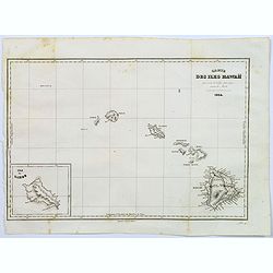
Carte des Iles Hawaii.
A lovely small map of the complete chain of Pacific islands known today as the Hawaiian islands, from Dumont d'Urville's atlas "Voyage pittoresque autour du Monde.&q...
Place & Date: Paris, 1834
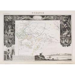
Océanie.
A very decorative 19th century map of the Pacific Ocean, with hand colored lines indicating the extent of Polynesia, Mirconesia, Melanesia, and Malaysia (or Southeast Asi...
Place & Date: Paris, 1850
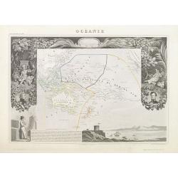
Océanie.
A very decorative 19th century map of the Pacific Ocean, with hand colored lines indicating the extent of Polynesia, Micronesia, Melanesia, and Malaysia (or Southeast Asi...
Place & Date: Paris, 1850
Part of South Australia.
Decorative steel engraved map of part of South Australia, surrounded by illustrations of Adelaide, natives on a catamaran, an Australian dog and a nymphicus bird illustra...
Place & Date: London, ca. 1851
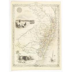
New South Wales.
Decorative steel engraved map of New South Wales, surrounded by illustrations of Sydney Cove, native trees and the seal of New South Wales. Interlocking border design. Ta...
Place & Date: London, ca. 1851
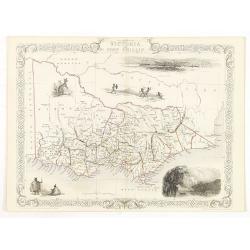
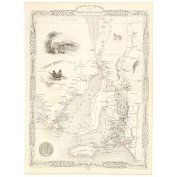
Victoria or Port Phillip.
Decorative steel engraved map of Victoria or Port Phillip, surrounded by illustrations of Melbourne, indigenous people and the Glenelg River. Interlocking border design. ...
Place & Date: London, ca. 1851
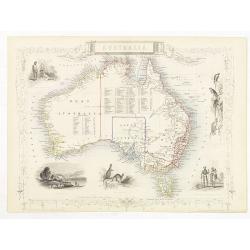
Australia.
Decorative steel engraved map of Australia, surrounded by illustrations of Sydney harbor, birds, kangaroos and local people. Interlocking border design. Taken from "...
Place & Date: London, ca. 1851
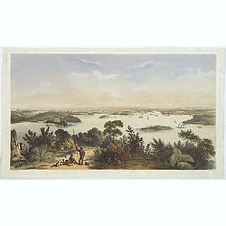
(The City And Harbour Of Sydney From Near Vaucluse.)
One of the most sought after views of the city and harbour of Sydney seen from Near Vaucluse, 1852. Magnificent hand-colored tinted lithograph and finished by gum-Arabic....
Place & Date: London, J. Hogarth, 1852
![[Collection of six maps of Australia and New Zealand.]](/uploads/cache/48412-250x250.jpg)
[Collection of six maps of Australia and New Zealand.]
Collection of maps including 6 engraved maps by 19th century German, French and English cartographers depicting Australia and New Zealand.This made to order atlas contain...
Place & Date: Germany, 1832-1852
![[Lot of Five Pacific Brand crate labels]](/uploads/cache/45706-250x250.jpg)
[Lot of Five Pacific Brand crate labels]
Five fruit crate label for Pacific Brand, showing a lemon and a map of the Pacific Ocean, centered on Hawaii and including a part of California and Asia, with also Austra...
Place & Date: Santa Barbara, 1917
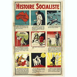
Histoire Socialiste.
Text includes “Imp. Centre de Propagande, des Républicains Nationaux, 102, rue Amelot, Paris (XIe), ou l’on peut se procurer cette affiche. Cette affiche ne peut êt...
Place & Date: Paris, 1931
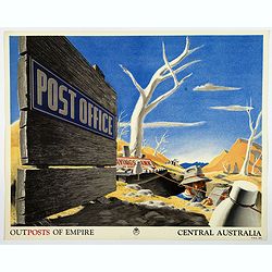
Outposts of Empire. Central Australia.
A large colored lithograph by John Vickery (1906-1983), he was an Australian artist. He worked in the fields of painting, illustration and advertising. He is the only Aus...
Place & Date: London, ca 1937