Browse Listings in Asia > South East Asia > Moluccas
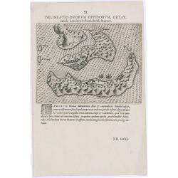
Delineatio Duorum Oppidorum, Ortat.
Early map of the Banda Islands.Theodore de Bry, a German engraver and book dealer, began a compilation of early voyages in 1590 and had published six parts at the time of...
Date: Frankfurt, 1609
Selling price: ????
Please login to see price!
Sold in 2025

Delineatio Civitatis et Castelli Amboinae.
Early view of Ambon, with 6 Dutch vessels offshore.Theodore de Bry, a German engraver and book dealer, began a compilation of early voyages in 1590 and had published six ...
Date: Frankfurt, 1609

De Landvoogdy der Moluccos met de Aangrenzende Eylanden . . .
Two charts on one sheet depicting the Moluccas islands. Little interior detail is given but the coastlines, settlements and principal coastal features are identified. To ...
Date: Amsterdam, 1726
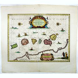
Insularum Moluccarum Nova description.
Exquisite map of the famous Spice Islands based. This map was the first large-scale map of the region and depicts the islands which provided first the Portuguese and then...
Date: Amsterdam, 1730
