Browse Listings in Asia

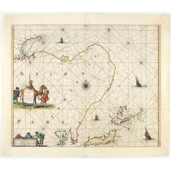
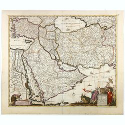
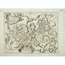
Turcicum Imperium.
A very handsome map featuring a particularly fine cartouche that depicts the Turkish Sultan on his throne, accompanied by allegorical figures on either side, brandishing ...
Date: Amsterdam, 1650
![Les Isles Philippines [on sheet with] Islas de los Ladrones ou Isle des Larrons.](/uploads/cache/42023-250x250.jpg)
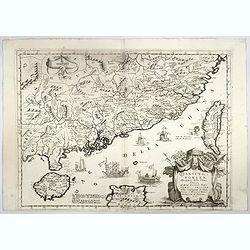
Les Isles Philippines [on sheet with] Islas de los Ladrones ou Isle des Larrons.
Sanson's important mid-seventeenth-century map of the Philippines and tha Ladrones.It was first engraved by J. Somer for the elder Nicolas Sanson with a privilege for twe...
Date: Amsterdam/Utrecht, 1654
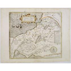
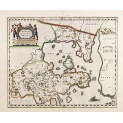
Terra Promissions.
A beautifully executed and very rare map of the Promised Land, divided into the 12 Tribes. The shore line runs in north-southwesterly direction from Sidon as far as Pelus...
Date: Paris, c.1655
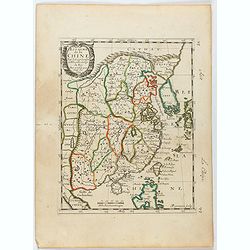
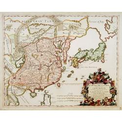
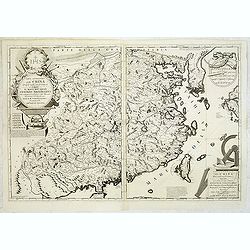
Royaume de la Chine. . .
Detailed map of China. Engraved by A.Winter. Attractive miniature map, depicting Korea as an island and parts of Japan, i.e. western part of Honshu and Kyushu.
Date: Paris, 1656
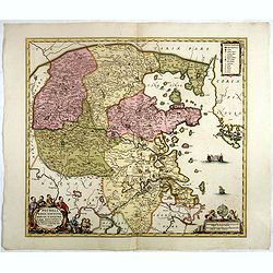
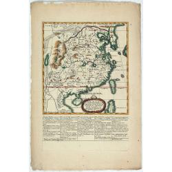
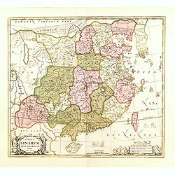
Pecheli, Xansi, Xantung, Honan, Nanking, In plaga Regni Sinensis. . .
A map of the northern provinces of China after the Jesuit Martino Martini, depicting Hebei (Pecheli), Shanxi (Xansi), Shandong (Xantung), Henan (Honan), and Jiangsu (Nank...
Date: Amsterdam, ca 1660
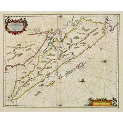
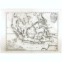
Sumatrae et insularum Locorumque nonnullorum circumiacentium. . .
Fine depicting the Island of Sumatra and the southern coasts of Malaysia from Quedo to Johore.North is orientated to the left of the page.Singapore is probably identifie...
Date: Amsterdam, 1660
Xantung, sinarum imperii provincia quatra.
A map of the northern province ‘Xantung’ of China after the Jesuit Martino Martini. Shows the Great Wall and is centered on the Bohai Sea, and the Shandong and Liaon...
Date: Amsterdam, ca 1660
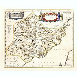
Fokien Imperii Sinarum Provincia undecima.
The province of Fokien lies opposite Taiwan and south of the region described in the above map. The coast is shown from Wen-zhou in the north to Fu-zhou and as far south ...
Date: Amsterdam, 1660
Xantung, sinarum imperii provincia quatra.
A map of the northern province ‘Xantung’ of China after the Jesuit Martino Martini.Shows the Great Wall and is centered on the Bohai Sea, and the Shandong and Liaonin...
Date: Amsterdam, ca 1660
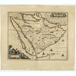
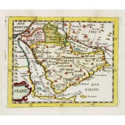
Arabia.
A handsome map of the Arabian Peninsula drawn on a large scale on which the three classical divisions are shown with some urban centers and topographical features. A cert...
Date: Amsterdam, 1662

Asiae Nova Apud Hudo Allardt. / Nova et exacta Asiae geograpicha descriptio.
Rare map of Asia, with relief shown pictorially. Shows Great wall of China and the mythical island of Yedso north of Japan. Title at head of map: Nova et exacta Asiae geo...
Date: Amsterdam, 1660-1665
Noordoost Cust van Asia van Japan tot Nova Zembla.
Important for its early depiction of Hokkaido and the Islands to the North of Japan. Ships navigate the seas around the Siberian, Chinese and Japanese coast extending as ...
Date: Amsterdam, 1666

Asie.
This rare map of Asia was published by Jollain in 1667. Published in "Trésor Des Cartes Geographiques Des Principaux Estats de Lunivers".This atlas is based up...
Date: Paris, 1667

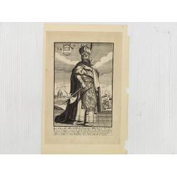
Impery sino Tartarici Supremus Monarcha.
Decorative costume plate showing Kam Hi son of the Shunzhi Emperor of China [1638 - 1661?], the second emperor of the Manchu Qing dynasty, who apparently supported the fo...
Date: Amsterdam, 1668
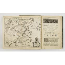
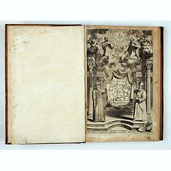
An embassy from the East-India Company of the United Provinces, to the Grand Tartar Cham, Emperor of China deliver'd by their excellencies, Peter de Goyer and Jacob de Keyzer, at his imperial city of Peking. . .
Very rare first English text edition of this most important and early resource on China and the Chinese. Three parts in one folio by John Macock for the author.Part I: An...
Date: London : Printed by the Author at his house in White-Friers, 1669
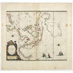
Paskaerte Zynde t'Oosterdeel Van Oost Indien, met alle de Eylanden daer ontrendt geleegen van C. Comorin tota aen Iapan.
1669 Pieter Goos ' eye-catching chart of Australia, Southeast Asia, China, Japan, Korea, and India. (With gold highlights.)
Date: Amsterdam, 1669
La Chine d'Athanase Kirchere de la compagnie de Jesus, illustrée de plusieurs monuments tant sacrés que profanes et de quantité de recherches de la nature. . .
Athanasius Kircher, S.J., (1601 or 1602-1680) was a 17th-century German Jesuit scholar who published around 40 works, most notably in the fields of oriental studies, geol...
Date: Amsterdam, 1670
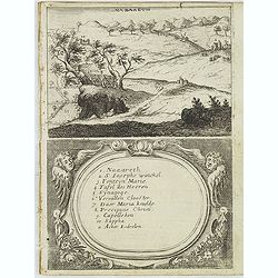
Nazareth.
Decorative view of Nazareth, below a decorative cartouche with numbered key and surrounded by 2 cherubins. Taken from a very rare travel book by Anthonius Gonsales, "...
Date: Antwerpen, Michiel Cnobbaert, 1673
![Rama. [Ramah]](/uploads/cache/30789-250x250.jpg)
Rama. [Ramah]
Town plan of Ramah, about 5 miles (8 km) from Jerusalem and near to Gibeah. Below a decorative cartouche with numbered key and surrounded by 2 cherubins.Taken from a very...
Date: Antwerpen, Michiel Cnobbaert, 1673
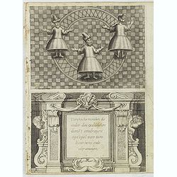
Turckschemoniken die onder den goddelycken. . .
Decorative picture of three dervishes dancers. Their whirling dance, also known as the sema, is a serious religious ritual performed by Muslim priests in a prayer trance ...
Date: Antwerpen, Michiel Cnobbaert, 1673
![Via Bethleem. [The route from Jerusalem to Bethlehem ]](/uploads/cache/30800-250x250.jpg)
Via Bethleem. [The route from Jerusalem to Bethlehem ]
The route from Jerusalem to Bethlehem. Below a lettered key. Taken from a very rare travel book by Anthonius Gonsales, "Hierusalemsche Reyse". The book describe...
Date: Antwerpen, Michiel Cnobbaert, 1673

La Ville et le Château de Zélandia dans l' île de Tayovan.
This important copperplate engraving is one of the earliest European views of Taiwan, depicting the Dutch fortifications and trading settlement on the West coast of the i...
Date: Amsterdam, 1675
Arabie.
Uncommon miniature map of the Arabian peninsula, from Pierre Duval's La Geographie Universeille dated 1676. Following his Cartes de géographie in 1657, Pierre Duval publ...
Date: Paris, 1676

Presqu''isle de L'Inde de ça le Gange.
Uncommon miniature map of India from Pierre Duval's La Geographie Universeille dated 1676. Following his Cartes de geographie in 1657, Pierre Duval published this smaller...
Date: Paris, 1676
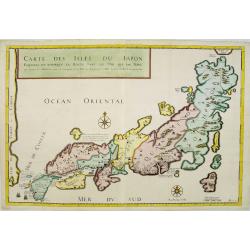
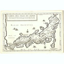
Carte des Isles du Japon Esquelles est remarque la Route..
This uncommon map of Japan, on a reasonably large scale, includes commentary on the country's natural features. For instance, Ocsaqui (Okazaki, near Nagoya) is said to ha...
Date: Paris 1679
Carte des Isles du Japon Sequels est remarque la Route..
This uncommon map of Japan, a reduced version of his larger map, contains comments about the nature of the country. For instance, Ocsaqui (Okazaki, near Nagoya) is said t...
Date: Paris / Amsterdam, 1679

Ambassades mémorables de la Compagnie des Indes orientales des Provinces Unies vers les empereurs du Japon.
First edition in French of this important work on Japan, a work whose illustrations "represent a high-water mark in book illustrations of the 17th century" (Lac...
Date: Amsterdam, 1680

Accuratissima totius Asiae tabula..
The map includes a detailed depiction of South East Asia and the Far East. The northern tip of Australia (Hollandia Nova) is shown as are the important discoveries made t...
Date: Amsterdam, 1680
Nova Persiae Armeniae Natoliae et Arabiae.
This fine map shows the area East from Cyprus to Iran, including The Saudi Peninsula, Red Sea, Nile River, Cyprus, Asia Minor, the Gulf of Aden, the Indian Ocean, Armenia...
Date: Amsterdam, 1680
-250x250.jpg)
Hern Johann Baptisten Taveniers..Vierzig Jaehrige Reize..
This German edition includes Tavernier's map of Japan in a reduced form (210x315mm) and contains legends about the country's nature, e.g., where gold is mined and plottin...
Date: Nuremberg, 1681
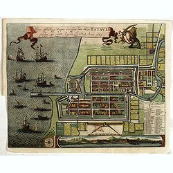
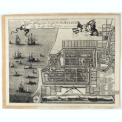
Waere affbeeldinge wegens het casteel ende stadt Batavia.
A good impression of this finely engraved and detailed plan of Batavia, present-day Jakarta, the Dutch center of trading activities in the East Indies. Copied after Cleme...
Date: Amsterdam, 1681
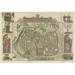
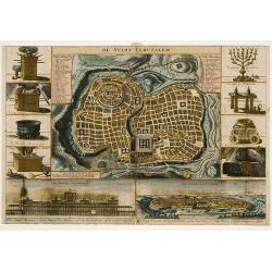
Jerusalem.
Engraved by Bastiaan Stoopendaal from Juan Bautista Villapando's imaginary town-plan of Jerusalem. This bird's-eye view is surrounded by 12 scenes, views and portraits of...
Date: Amsterdam, 1682
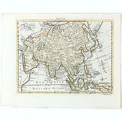
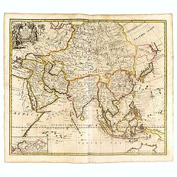
Asia.
Detailed map the Asian continent. The map is of interest for the use of Sea of Corea, the sea between Korea and Japan.
Date: Amsterdam, 1682
Selling price: ????
Please login to see price!
Sold in 2023
Il regno della China detto presentente Catay e Magnin. . .
A rare and decorative Italian map of China and Japan, with Japan closely modelled on the indented Cardim outline and Hokkaido, called Yuppi , shown as an Asian peninsula....
Date: Rome, 1682

Grande Tartarie (de L'Asie / Figure V).
A fine and uncommon early 17th century map of Tartary with Korea. and the name USBECK showing in present-day Usbekistan.From the French text edition of "Description ...
Date: Paris, 1683
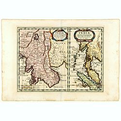
Indiae extra Gangem Pars Septentrionalis. Indiae extra Gangem Pars Meridionalis.
The map on the left depicts the northern portion of the India Ganges region, representing Burma (Myanmar), Thailand, Cambodia, Vietnam and Laos. The right one depicts th...
Date: Utrecht / Amsterdam, J.Halma, 1683
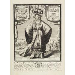
La Reine de la chine.
Very rare and decorative costume plate. In the background : Palais Royal Peking. Beneath the plate a descriptive text about the Queen of China.Bears the address : Se vend...
Date: Paris, ca. 1685
Le Grand Mongol. . .
Rare full portrait of the Mongol emperor of Indostan, published by map seller, François Jollain, the Elder (1641-1704), active in Paris, rue St. Jacques à la ville de C...
Date: Paris, ca. 1686
Paradigma XV Provinciarum et CLV Urbium Capitalium Sinensis Imperij Cum Templis quae Cruce X Signatur Et Domiciliis S.I.
First edition of this rare Jesuit map of China, published by Jean Baptiste Nolin in Paris and based on Philippe Couplet's map of 1686. The map shows China's 15 provinces ...
Date: Paris, 1686
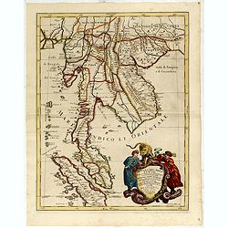
Penisola Dell India di la dal Gange Diusa ne i Regni, che in essasi contengono et accresciuta di varie notizie. Da Giacomo Cantelli da Vignola e conforme le Relationi di alcuni Padri della Compa di Giesu di Monsu Tavernier . . . 1683
Giacomo Rossi's fine late 17th century map of Malaysia, Thailand, Cambodia and part of Sumatra.. Engraved by Franciscus Donia. Issued in Il Mercurio geografico In lower r...
Date: Rome, 1683-1688
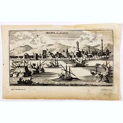
Mocha, in Arabien. (View of Mocha, Yemen.)
Magnificent bird's eye-town-view of Mocha in Yemen.. Etched by Gaspar Bouttats (1640-1695).The Antwerp based publisher Jacques Peeters published ca. 1690 a series of prin...
Date: Antwerp, c.1690
Iunan, Queichev, e Quangsi Provincie della Cina. . .
A beautiful map depicting the area of Beijing with decorative title cartouche and scale cartouche. Information about the area at the top of the map.The remarkable Vincenz...
Date: Venice, 1690
Quantung, e Fokien, Provincie della China...
A beautifully engraved decorative map of Southern China extending from Hainan in the West to Formosa in the East and centered on the Pearl River Delta with Macao and the ...
Date: Venice, 1691
Isola del Giapone e penisola di Corea.
A most attractive and decorative map by Vincenzo Coronelli. An elaborate central title cartouche garlanded with intertwined flowers and dedicated to the Rev.de Fontaine o...
Date: Venice, 1692
![[Arabia]](/uploads/cache/40143-250x250.jpg)
[Arabia]
A lovely miniature map of the region of Armenia and Georgia, showing both parts of the Black Sea and Caspian Sea. For such a small map, it renders a wealth of detail, wit...
Date: Ulm, 1692
Het gezandtschap der Neerlandtsche Oost-Indische Compagnie, aan den grooten Tartarischen Cham, Den tegenwoordigen Keizer van China. . .
Third edition of this beautifully illustrated work on China. The first edition was published in 1665.Jan Nieuhof was a "Dutch traveler and adventurer" (1618-72)...
Date: Amsterdam, W. Waasberge, 1693
Parte orientale della China.. / Parte occidentale della China. (2 sheets)
The map depicts the eastern part of China with Korea -correctly- as a peninsula. Formosa is included as well. Japan is partly visible i.e. the area of Yamaguchi, strait K...
Date: Venice, 1695
Isole dell'Indie. . .
A beautiful and flamboyantly engraved large-scale map of the East Indies, including the Malay Peninsula, Cambodia, the Philippines and all of Indonesia and the Spice Isla...
Date: Venice, 1696

Penisola dell'Indo di qua del Gange, e l isola di Ceilan..
India below the Tropic of Cancer, with an inset of Ceylon and Trincomalee.The remarkable Vincenzo Coronelli (1650-1718), encyclopaedist, geographer, inventor and Doctor o...
Date: Venice, 1698

Le Royaume de Siam avec les Royaumes. . .
Influential map of the Malay peninsula, Sumatra, Java and Borneo, centered on Singapore. Mortier incorporated information provided by the French Jesuits and charts the ro...
Date: Amsterdam, 1700

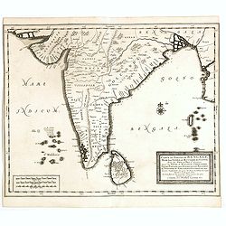
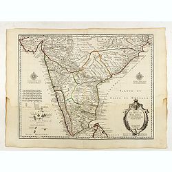
Presqu Isle de L'Inde. deca la Gange.. .
Two maps together on one sheet. General map showing the southern part of India, including the northern part of Shri Lanka. In an inset a detailed map of the most southern...
Date: Amsterdam, 1700
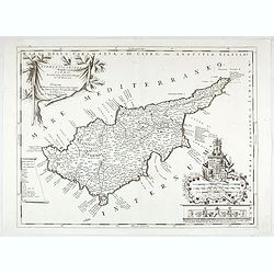
Acamantis insula hogidi Cipro . . .
Decorative map of Cyprus. The remarkable Vincenzo Coronelli (1650-1718), was a Franciscan Friar and appointed General of the Order in 1701. He was cosmographer to the Rep...
Date: Venice, 1700
Chorographia Terrae Sanctae in Angustiorem. . .
Rare. Large visually rich map decorated with illustrations of the sacred objects and places of Judaism. In the bottom center is a plan of ancient Jerusalem, and the route...
Date: Amsterdam, ca. 1700

Carte de la Turquie de l'Arabie et de la Perse.
Very rare state with the address : Chez l’Auteur, Rue des Canettes prez St. Sulpice. Avec Privilège, 1701". This early state with "rue des Canettes" imp...
Date: Paris, 1701

A Mapp of Batavia with all itts Forts.
Wonderful, scarce, and decorative plan of present-day Jakarta, showing the City and its immediate environs, the surrounding rice fields intersected by a network of waterw...
Date: London, Printed for A. and J. Churchill, 1703

Les Vrays Indes dits Grands Indes ou Indes Orientales Par N. de Fer. Geographe de Sa Majeste Catoliques et de Monseigneur le Dauphin.
Detailed map on India, Thailand, the Malay Peninsular and the south coast of China up to Macao. The map was engraved by C. Inselin.
Date: Paris, 1705

Prequ Isle de L'Inde deca Le Golfe du Gange (and) Prequ Isle de l'Inde dela le Golfe du Gange.
A very rare double map of India, Sri Lanka and the Maldives islands, together with a separate map of Cambodia, Thailand, Malaysia and North Sumatra. The map shows Bangkok...
Date: Brussels, Antwerp, 1706

Carte de L'Egypte de la Nubie de L'Abissinie..
Including the Arabian Peninsula. Giving good detail on Egypt. Engraved by Desrosiers. Address and date changed, now with the imprint "A Paris Chez l’Auteur sur le ...
Date: Paris, November 1707

De kusten van Arabie het Roode Meer en Persize Zee..
Map of the Arabian Peninsula till West Coast of India, southern Persia and the 'Horn of Africa'. Although not renowned for the originality of his work, Pieter van der Aa ...
Date: Leiden, 1707
![Le Royaume de Siam avec Les Royaumes Qui Luy sont Tributaries & c. / La Royaume de Siam avec les royaumes qui luy sont Tributaires, et les Isles de Sumatra, Andemaon, etc. . . [two sheet map]](/uploads/cache/40698-250x250.jpg)
Le Royaume de Siam avec Les Royaumes Qui Luy sont Tributaries & c. / La Royaume de Siam avec les royaumes qui luy sont Tributaires, et les Isles de Sumatra, Andemaon, etc. . . [two sheet map]
Influential map of Southeast Asia and the East Indies including modern day Thailand, southern Vietnam, Cambodia, Malaysia, Singapore, Borneo, Sumatra and Java. Ottens inc...
Date: Amsterdam, 1710
De Stadt Jerusalem.
Plan of ancient Jerusalem from a Dutch bible after Villalpando. The print is in contemporary colors, which is extremely rare for a plate like this. Lower left the Temple ...
Date: Amsterdam, 1710
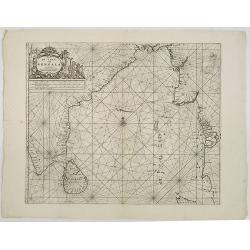
De golf van Bengalen.
Rare chart of the Indian Ocean, with nice detail on Ceylon (Sri Lanka) with compass roses and a system of rhumb lines, soundings and anchorage's. Many place names. The pl...
Date: Amsterdam, after 1669-1712

Le détroit de Malacca . . .
Map of Malacca. The map details the Strait of Malacca from P. Peru and Tanjong Goeree to Lingen and Pulu Panjang. Malacca and Ihor (Johore), along with numerous other coa...
Date: Leiden, 1712
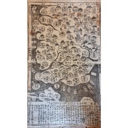
Paldobundo Province.
Woodblock printed map of Jeolla Province which was one of the historical Eight Provinces of Korea during the Kingdom of The map is drawn in "Paldo Bundo," styl...
Date: 1710-1718

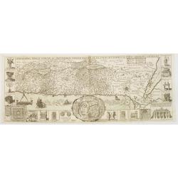
Terki, ville de la Circassie, dans l'Asie.
A very detailed panoramic view of Terki in the Caucasus, the capital of one of the most powerful Dagestani potentates of southeast Asia.Showing the Volga River.The town o...
Date: Leiden, c. 1719
Carte du Golfe de Bengale, mer des Indes et rivieres du Gange . . .
Detailed scare map of the Southern part of India with Ceylon. Good detail along the coasts of Malabar, Coromandel, the Maldives islands and the Kingdoms of Visipour, Golc...
Date: Leiden, 1719

Carte du Golfe de Bengale, Mer de Indes, et Riviere du Gange, Avec les Pais et Iles d'alentour, Savoir les Cotes de Malabar, Cormandel, Ile de Ceylon, Les Maldives . . .
Detailed map of the Southern part of India with Ceylon. Good detail along the coasts of Malabar, Coromandel, the Maldives islands and the Kingdoms of Visipour, Golconda, ...
Date: Leiden, 1719

Saba, ville en Perse.
Decorative view of Sabā / Dakān Sorkh) which is a village in Vahdatiyeh Rural District in present-day Iran.In the foreground are camels and horses. This well-executed e...
Date: Leiden, 1719
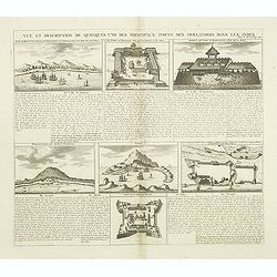
Vue et Description de Quelques-Uns des Principaux Forts des Hollandois dans les Indes .
Interesting sheet with seven detailed views illustrating the most important Dutch V.O.C. trading outposts and fortified colonial possessions in the East Indies, including...
Date: Amsterdam, 1720

Arabiae Felicis, petrae et desertae.
A very striking map with a finely decorated title cartouche, published by Valk & Schenk, utilizing Jansson's original plate. Interestingly, this map uses the names th...
Date: Amsterdam, 1720
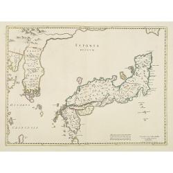
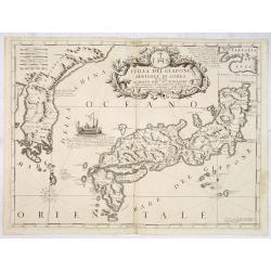
Japonia Regnum.
It is the first map to correctly show Korea as a peninsula. The rare Covens and Mortier issue of this important map of Japan and Korea, originally published by Blaeu. Thi...
Date: Amsterdam, 1655 - 1720
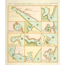
Carte des Principales Ports de Mer Bancs de sable &c: qui sont dans la Mer Rouge..
Some cities existed along the western coast of the Arabian peninsula, where they served as entrepots for transcontinental trade between Europe and Asia. Mecca, founded by...
Date: Amsterdam, 1720
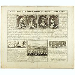
Habillement des femmes de Smyrnes, des Grecques et des Juifs de cette ville.
Four portraits of Smirne women in typical dress, each with a descriptive engraved text. From Chatelain's monumental 7 volume "Atlas Historique".Henri Abraham Ch...
Date: Amsterdam, 1720
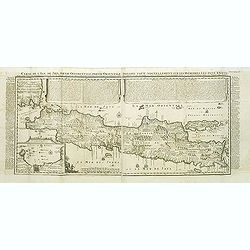
Carte de l'Ile de Java.
An inset plan of Batavia and clearly indicated rice fields, mountains, forests, towns in profile and even elephants suggest the wealth of detail found on this map. Modele...
Date: Amsterdam, 1720
Imperii Sinarum nova descriptio.
Schenk and Valk's rare early 18th century issue of Janssonius milestone map of China, Korea and Japan after Martino Martini. Engraved by Johannes van Loon. The overall ba...
Date: Amsterdam, ca. 1720
A New Map of Asia from the latest Observations Most Humbly Inscrib'd to the Right Honbl. George Earl of Warrington &c.
Fine map of Asia, with decorative title cartouche flanked by two figures in Asian dress, along with flora and fauna of the continent., based on the work of Guillaume De L...
Date: London, 1721
Waere Affbeeldinge Wegens het Casteel ende Stadt BATAVIA Gelegen opt Groot Eylant Java.
A good impression of this finely engraved and detailed plan of Batavia, present-day Jakarta, the Dutch center of trading activities in the East Indies. Copied after Cleme...
Date: Amsterdam, 1721
Carte des Cotes de Malabar et de Coromandel..
Detailed and attractive map of India and the northern tip of Sri Lanka. With decorative title cartouche and two compass roses.Rare edition with address : A Paris chez l�...
Date: Paris, 1723
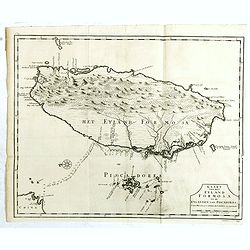
Kaart van het Eyland Formosa en de Eylanden van Piscadores.
The earliest printed map of Taiwan or Formosa. Oriented to the east, with north at the left, covering the entire island and the nearby Pescadores, now known as the Penghu...
Date: Amsterdam, 1724
