Japan's encounter with the world

TADAYOSHI MIYOSHI
Kobe City Museum
In 1543, some Portuguese sailors on a Chinese ship drifted ashore on Tanegashima Island in Kyusu, thus inaugurating exchanges between Japan and Europe. But the Tokugawa Shogunate established a seclusion policy about a century later, severely restricting exchanges between Japan and Europe. Two important innovations from Europe for Japan during the one hundred years of seclusion were firearms and Christianity. These had a great impact on Japanese history and culture. European maps also had a significant influence, as did firearms and religion.
Westerners thought they had discovered the unknown country of gold, Zipangu. This had happened accidentally in that great age of discovery, making clear another point on the globe's surface. However, the incident meant even more from the Japanese perspective, as it prompted the Japanese people to acknowledge the outside world. Till that time, the Japanese people had their own geographical concept of the world consisting only of Japan, China, and India. Exploration activities during the Great Age of Discovery played an important role in spreading geographical knowledge from the West to civilizations worldwide. Such encounters between Japanese and Western views were made in the second half of the 16th century. This impact led to the production of the folding-screen world map.
DAWN OF THE MODERN CARTOGRAPHY
The second half of the 16th century is notable as the dawn of modern cartography in Europe. Literary works on geography and maps by Claudius Ptolemaeus in the second century were revived in the early 15th century after a long period of neglect during the Middle Ages and were distributed in print at the end of the century. Portugal and Spain began exploring the unclaimed areas on the maps. They sent exploration voyages to many parts of the world in the late 15th and early 16th centuries, led by Vasco da Gama, Christopher Columbus, Ferdinand Magellan and other explorers. They confirmed that Zipangu was actually Japan, identifying it as the easternmost point of the Eurasian continent. Maps started to depict all parts of the globe.
 The second half of the 16th century was also a period of notable progress in cartographic projection, and maps began to be printed and distributed by mapmakers in the Low Countries of northern Europe. A typical
example of the development of modern cartography is Theatrum
Orbis Terrarum by Abraham Ortelius, the atlas of the world
published in Antwerp.
The second half of the 16th century was also a period of notable progress in cartographic projection, and maps began to be printed and distributed by mapmakers in the Low Countries of northern Europe. A typical
example of the development of modern cartography is Theatrum
Orbis Terrarum by Abraham Ortelius, the atlas of the world
published in Antwerp.
The first map shows how people in those days saw the world. It looks somewhat awkward to us. A giant island lies in the North Pole area, and in the Southern Hemisphere, a massive continent extends across modern Australia. But the general idea of the world is not very different from that of today. Missionary boys brought the atlas back to Japan when they returned from their trip to Europe in 1590, and it is certain that the Japanese people in those days shared the same geographical view of the world.
ACCEPTING EUROPEAN MAPS
While views and maps of the world were encountered and exchanged between the East and West in the second half of the 16th century, the Japanese learned much from European maps, as evidenced by folding-screen maps. More than twenty works produced from the Azuchi-momoyama to the early Edo period (late 16th century through the early 17th century) are well known. Maps showed variety, including a world map, a pair of maps of the world and Japan, a city map, and a pair with a map and a western painting.
Four such folding-screen maps are believed to be the first Japanese maps based on European maps of the late 16th century, or the Azuchi-momoyama period. (One is owned by Jo-toku-ji temple in Fukui Prefecture; the others are privately owned). Three folding screens feature gorgeous, dazzling paintings of quite exotic motifs, believed to have been created by painters who learned their craft at a Jesuit-run art school. (The three screens are owned by the Imperial Household Agency, Kosetu Museum of Art and Kobe City Museum respectively.)

Meanwhile, researchers in the East and the West have found that the screen maps created by painters at the Jesuit school are based on the world map by the Dutch cartographer Petrus Kaerius, created in 1609. Japan's acquisition of European maps shifted from the Spanish and Portuguese style to the Dutch style, which conformed to the major trend of Japanese history.
Kaerius's 1609 world map features paintings of the ten most powerful sovereigns of the time surrounding it. The figures of the sovereigns around the map were adopted as a motif in Taisei Oukou Kiba-zu Byobu, the folding screens depicting Western royal cavalry, which are fine examples of Japanese art from the early days of Western influence. They are owned by the Kobe City Museum and Suntory Museum of Art. This shows that the world maps introduced to Japan in those days were not only an important means of conveying geographical information but also influenced Japanese culture in early modern times in many ways.
In particular, the folding-screen map owned by the Imperial Household Agency is acclaimed as the best world map of its day. The map inherited almost all of the original map's features, with some improvements in the representation of Japan and Asia, which is quite meaningful. Another remarkable feature is that ten cities are marked on the map of the Japanese archipelago. Not all cities are identified, but the largest ones are recognized as Edo and Kyoto/Osaka, and one is identified as Sunpu, given the distance between the mark and Izu Peninsula on the map. The reason why Sunpu was chosen as one of the ten major cities is probably that Tokugawa Ieyasu lived there for the last ten years of his life. According to historical records, Tokugawa Ieyasu viewed the folding screen with world maps in September 1611. The folding screen world map owned by the Imperial Household Agency might be the one Ieyasu looked at. It would be quite difficult to prove this, given how long it would have taken for the original to reach Japan, but many historians believe it is so.
There are other examples of maps inspired by Kaerius's world map. The one owned by Kosetsu Museum of Art forms a pair with a world map and a painting of the battle between Roman soldiers and pagan Turkish soldiers. The one owned by Kobe City Museum forms a pair with a world map and city maps of Lisbon, Seville, Rome, and Constantinople, all with a Christian feel. Another feature of this map is that the original rectangular map, described using the Mercator projection, was transformed into an egg-shaped one, and Japan appears at a massive size on a protruding part. In addition, ship figures appear on the map in the East China Sea, which are not present on the original map. They are suspected to be government-approved trade ships, which suggests this map is quite important, as it tells us more than mere decorative art would.
UPDATED VERSIONS OF SPANISH AND PORTUGUESE MAPS
The early 1590's were a notable turning point in the history of maps in Europe and in Japan, when Japanese map artists began producing folding-screen maps based on world maps introduced by the Spanish and Portuguese. During this period, Japan's understanding of world geography underwent a complete change. Japan studied European maps and reproduced them on folding screens. On the other hand, Europe also improved its geographical knowledge of Far East Asia.
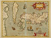 The 'discovery' of Japan in
1543 was, for Europeans, the solution to the old question of where
the eastern side of the Eurasian continent ended, a question that had remained unsolved since Ptolemaeus' day. However, Japan and the surrounding
areas must have been mapped out based on limited information and
imagination. Even the Portuguese map, made by the discoverers, shows the Japanese archipelago in a shape quite
different from reality. The Theatrum Orbis Terrarum, produced by Ortelius in 1570, has two different depictions of Japan in a single atlas.
But the Japan depicted on the map created by the Portuguese cartographer Teixera in 1595 is recognizable at a glance. This means that Europe had
acquired new knowledge about Japan's map immediately before Teixeira made his map, which was quite new to Europeans and different from what they had known until then. Similarly, a group of
the oldest folding-screen maps made in the 1590's has more
sophisticated descriptions of Japan and the Far East than European
maps of the same period. This indicates that Japan (or Asia)
created its own new maps in this period.
The 'discovery' of Japan in
1543 was, for Europeans, the solution to the old question of where
the eastern side of the Eurasian continent ended, a question that had remained unsolved since Ptolemaeus' day. However, Japan and the surrounding
areas must have been mapped out based on limited information and
imagination. Even the Portuguese map, made by the discoverers, shows the Japanese archipelago in a shape quite
different from reality. The Theatrum Orbis Terrarum, produced by Ortelius in 1570, has two different depictions of Japan in a single atlas.
But the Japan depicted on the map created by the Portuguese cartographer Teixera in 1595 is recognizable at a glance. This means that Europe had
acquired new knowledge about Japan's map immediately before Teixeira made his map, which was quite new to Europeans and different from what they had known until then. Similarly, a group of
the oldest folding-screen maps made in the 1590's has more
sophisticated descriptions of Japan and the Far East than European
maps of the same period. This indicates that Japan (or Asia)
created its own new maps in this period.
Before the Edo period, there were no maps in Japan, except for several examples of general maps known as Gyoki-zu, drawn in simple shapes used since ancient times. Representations of Japan on folding map screens are an advanced version of such Gyoki-zu, and highly developed. The late 16th century is truly a turning point in the history of maps both in Japan and Europe.
The late 16th century was also a turning point in another respect. The chief missionary of the Jesuits, Alessandro Valignano, left reports of his tours in Japan in 1583 and 1592. A comparison of his accounts of Japanese geography shows that the second report is in much greater detail than the first. Valignano wrote that the detailed information on Japanese geography in the second report is attributable to the devoted research by a person named I.Moreira. His statement is quite important. Given documents by Jesuit missionaries in the 17th century, such as the representation of Asia on Kon-yo Bankoku Zenzu, a large map of the world created by Matteo Ricci and the description of the Japanese geography in History of the Churches in Japan by Joao Rodriguez, it appears that the Jesuits acquired detailed information on the geography of Japan and Asia. Some historians say that the Society had strong interest in creating maps of the areas where they went on missions and was involved in producing new maps of Asia. The late 16th century was the time when Europe truly discovered Japan.
Considering the facts I have mentioned so far, even though it has been a matter of controversy, it seems that the Europeans initiated the development of cartography in Japan. Some historical records suggest that Japan provided information that helped make the maps more sophisticated.
No clear evidence has been found so far to resolve the controversy, and all we can do now is collect circumstantial evidence. I believe that the development of cartography in Japan is attributable not solely to one-sided efforts by Japan or Europe, but the results of exchanges of information. However, it is reasonable to consider that Europe contributed more to the development of maps in Japan and the Far East, from the perspective of the representation of the Japanese archipelago on world maps. The folding screen maps do not simply indicate that Japan learned from European maps and reproduced them on folding screens. They mean a significant turning point in the history of cartography in Europe. Artists who made folding-screen maps produced first-class world maps that were not to be found anywhere in Europe. I earnestly hope for more research to be conducted on folding-screen maps that provide evidence of large-scale cultural exchanges between the East and the West.
